


Polish Presidential Flight Crash Thread

Join Date: Jun 2009
Location: Finland
Age: 91
Posts: 21
Likes: 0
Received 0 Likes
on
0 Posts
RSBN (Radiosistema Blizhney Navigatsii) is the Soviet TACAN analogue. It has approximately the same features:
● VOR-like operation (fly a radial to or from the beacon, intercept radial)
● Automatic flying of arcs at a specified distance ("Orbita" mode)
● Automatic flight in the vicinity of a beacon (SRP mode), to a specified point on a track parallel to a certain radial
● Notification when reaching a point on a radial at a specified distance
● ILS functionality ("Katet" mode) if the beacon has additional equipment (eg PRMG) coupled to it at the airfield
● "Meeting" mode where two airplanes could find each other in "peer-to-peer" radio comm
● "Ident" mode whereby pressing a button in the cockpit would "blip" the airplane on the radar screen (a small ATC station could be driven from the RSBN station on-site).
RSBN beacons are also mobile (often mounted on trucks) and easy to deploy in the field. To this day the Russian military use RSBN for different operations, and some military RSBN stations are enabled from time to time to provide for seasonal operations on the most important airfields. A beacon is tuned using the "channel" just as TACAN. Channels have two digits - 0 to 4 and 0 to 9, this makes 44 channels available at any given time. RSBN station handling ILS-like operations could service less airplanes at the same time, so Soviet airfields would often operate a spare RSBN unit to provide glideslope and localizer.

Join Date: Mar 2009
Location: us
Age: 63
Posts: 206
Likes: 0
Received 0 Likes
on
0 Posts
- are you trying to say that these 'readouts' were baro? How do you account for the 2 100m calls 7 seconds apart? Are you saying they levelled off at 100m for 7 seconds? They still had '20m' or so ABOVE the runway just before they crashed, yet they crashed below the runway elevation.
I think you should put the 'baro' theory to rest?
I think you should put the 'baro' theory to rest?
The last callout = 20 m happened 4 secs before the crash. At the rate they were sinking that puts the crash at -20 m below runway level which is almost exactly where they crashed in real life (-15 m). So all the pieces fit
Last edited by vovachan; 19th Jun 2010 at 20:23.
One problem with your theory. The RA 400 Hz warning sound at 60 m.
The first tree, 1100 m from the rwy threshold was cut 10,8 m from the ground, about 5 m below the rwy level.
Arrakis
The first tree, 1100 m from the rwy threshold was cut 10,8 m from the ground, about 5 m below the rwy level.
Arrakis
Per Ardua ad Astraeus
Join Date: Mar 2000
Location: UK
Posts: 18,579
Likes: 0
Received 0 Likes
on
0 Posts
Vov - how do you explain going from your 'level flight' at 100m to 'losing' 40m in 3 secs? That's a fair rate of descent (800m/min average) - making something like 1600m/min peak - to generate suddenly! Then a most erratic rate - based on baro readings. Check also 40m/30m and 20m - rate of descent according to you doubles between 30 and 20? Have you ever tried flying an aeroplane like that? Tried plotting them?
Join Date: Jun 2010
Location: United States
Posts: 16
Likes: 0
Received 0 Likes
on
0 Posts
Vakakaaa,
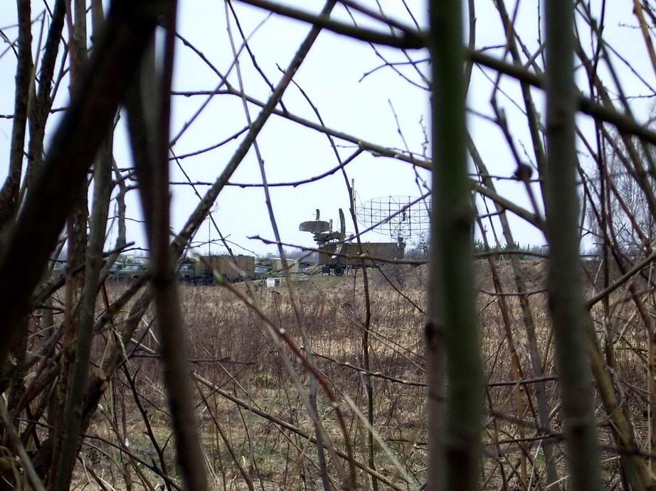
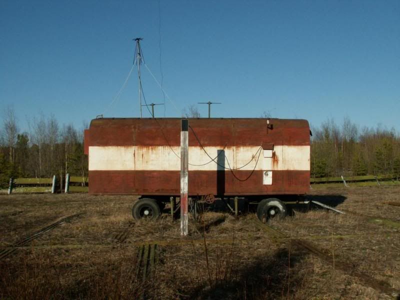
The Latvians have a pretty good handle on the радиотехническая система ближней навигации (RSBN) when they show the РСП-6 at Andreapol at the link, this is the same antenna system that was in the photo at Smolensk North.
What is not known is what the antenna it is being interfaced to on the left.
Two things are known however, there was a Par-10 at the beacon.
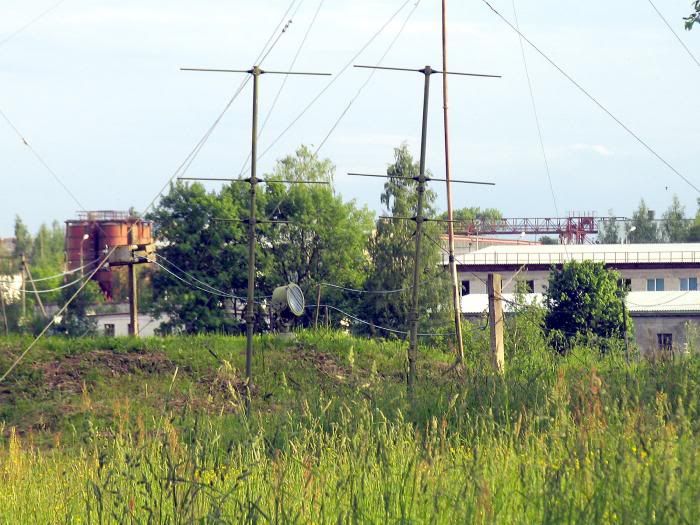
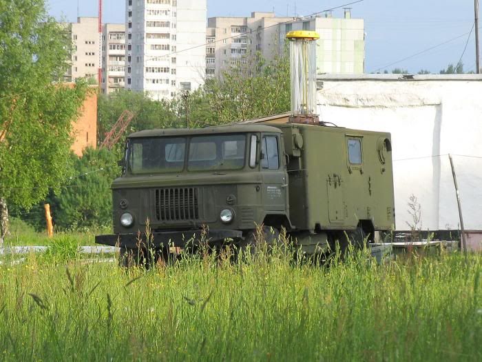
Photo of Par-10 mobile unit in Gaz-66 below. (Note cylinder on back of trailer.)

And the lantern that is used to send out Morse code and alert the aircraft on the position of the marker beacon during heavy fog was interfaced with the GAZ-66.
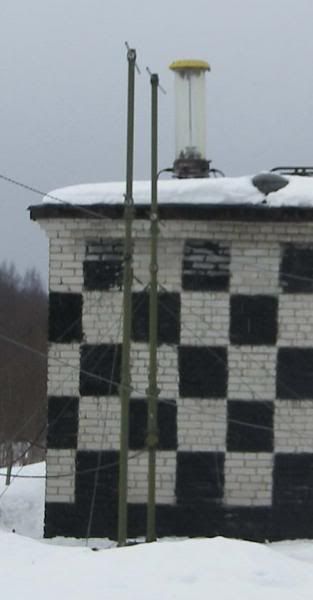
Par-10S at Kipelovo airfield below. Note lantern on top of building and T- antennas (3 prong).
I will state it again, there is no mention of the lantern being seen by the pilot on descent and quite frankly since the Russians have said parts of the CVR was damaged, the transcripts could very well be incomplete.
I am reminded of the saying, now for the rest of the story when I read the transcripts. Somehow, I don't think the rest of the story will be told.
Given the pre-flight on the poor weather being left out, I have to wonder what was told to the pilots in pre-flight. I saw one translation state the pilot said, no ILS?
The Latvians have a pretty good handle on the радиотехническая система ближней навигации (RSBN) when they show the РСП-6 at Andreapol at the link, this is the same antenna system that was in the photo at Smolensk North.
One of the main tasks of radio systems for aviation operations of all departments are the need for navigation and landing aircraft in adverse weather and at night. Before the advent of satellite navigation systems, these problems were solved with the help of ILS systems range navigation and landing. Most common in the world have ILS system, VOR / DME, ILS, TACAN and RSBN / PRMG.
What is not known is what the antenna it is being interfaced to on the left.
Two things are known however, there was a Par-10 at the beacon.
Photo of Par-10 mobile unit in Gaz-66 below. (Note cylinder on back of trailer.)
And the lantern that is used to send out Morse code and alert the aircraft on the position of the marker beacon during heavy fog was interfaced with the GAZ-66.
Par-10S at Kipelovo airfield below. Note lantern on top of building and T- antennas (3 prong).
I will state it again, there is no mention of the lantern being seen by the pilot on descent and quite frankly since the Russians have said parts of the CVR was damaged, the transcripts could very well be incomplete.
I am reminded of the saying, now for the rest of the story when I read the transcripts. Somehow, I don't think the rest of the story will be told.
Given the pre-flight on the poor weather being left out, I have to wonder what was told to the pilots in pre-flight. I saw one translation state the pilot said, no ILS?
Last edited by 210thars; 20th Jun 2010 at 09:42. Reason: correct first link
@210thars
Quite don�t understand your message.
The first picture shows a typical arrangement of a mobile precision approach radar (PAR). The big antenna beeing the area surveilance radar (ASR, turning 360�), the smaller vertical antenna is the glideslope antenna of the PAR (turning few degrees up and down) and the smaller horizontal antenna is the course antenna (turning few degrees left and right) of the PAR.
Do you have proved information, that such equipment was available at the time of the accident and used?
The PAR-10 is the radio equipment of the beacon. Without that there would be no beacon. Do not mix up the name of the system with the "PAR" (Precision Approach Radar) approach.
The thing with the lantern i find very funny. Imho it is for no use in an approach during bad weather. I was used to strobelights on the extended runway center line, they improved the possibilities to identify the runway to some degree. How a lantern on a truck standing not even in the approach sector but somewhere midfield or at the beacon could help is outside my thinking.
There will have been no identification of the lantern whatsoever, so there will nothing concerning that be on the CVR either.
franzl
Join Date: May 2010
Location: EU
Age: 82
Posts: 5,505
Likes: 0
Received 0 Likes
on
0 Posts
RetiredF4
Franzl,
Lanterns:
See transcript at 10:35:05.0 and between 10:29:18.2 - 20.0 and http://www.pprune.org/rumours-news/4...ml#post5729466. Agree that they may not have seen them, being so low.
MvG RD
Lanterns:
See transcript at 10:35:05.0 and between 10:29:18.2 - 20.0 and http://www.pprune.org/rumours-news/4...ml#post5729466. Agree that they may not have seen them, being so low.
MvG RD
Last edited by RegDep; 20th Jun 2010 at 11:00. Reason: Typo and addition
Join Date: Jun 2009
Location: Finland
Age: 91
Posts: 21
Likes: 0
Received 0 Likes
on
0 Posts
210thars : franzl already commented. On the left in your pic 1 is communication truck (SKP) with discone antennas.
In the last (Kipelovo) photo also shown �code lantern� but the up pointing vertical double-yagi is a normal component of PRMG landing system, much like ILS Marker antenna but with different audio modulation (3000 Hz) and some other features.
Normal non-directional beacon which we know as locator (LO, LM, LOM, LMM) is problematic in Russian language. For them lokator = Radar ! For them our generic �NDB� is privodnaya radiostantsiya (in English = Homing station), when in a landing system �far� = ДПРМ and �near� = БПРМ.
All pilots are too well aware that NDB aka locator is good for homing with ADF, while Marker (OM, MM) (almost always 75 MHz) will not help.
NVA-Fliegers explain (almost) everything like only Germans can explain. Komplexes Landesystem SP-1 divided into OSP, RSP, PRMG, RSBN. OSP includes essential rather peculiar lighting system with already shown (morse coded) Light beacon, SKP communication and a number of navigation systems. Franzl can no doubt give helping hand with German language.
Flugsicherungsmittel an FP - Die Ausbildung zum Hubschrauberf�hrer der NVA. Ich hab's erlebt.
Last edited by vakakaaa; 22nd Jun 2010 at 06:03. Reason: Typos and additions
Lanterns:
See transcript at 10:35:05.0 and between 10:29:18.2 - 20.0 and http://www.pprune.org/rumours-news/4...ml#post5729466. Agree that they may not have seen them, being so low.
MvG RD
See transcript at 10:35:05.0 and between 10:29:18.2 - 20.0 and http://www.pprune.org/rumours-news/4...ml#post5729466. Agree that they may not have seen them, being so low.
MvG RD
APM 90 M
It might have been also a simplified system like stated in the first pictures of the crash site, just some lamps on wooden poles.
franzl
Last edited by RetiredF4; 20th Jun 2010 at 13:47.
NVA-Fliegers explain (almost) everything like only Germans can explain. Komplexes Landesystem SP-1 divided into OSP, RSP, PRMG, RSBN. OSP includes essential rather peculiar lighting system with already shown (morse coded) Light beacon, SKP communication and a number of navigation systems. Franzl can no doubt give helping hand with German language
Everything said already, here a translation to the lantern:
The code beacon is deployed at the position of the Inner marker beacon. It provides the pilot at night with a visual indication of the distance to the runway (1000m) and assigns a unique identifier of the airport and the approach direction. The identification is with morse-code at a rate of 15 codes per minute.
The code consists of nine fluorescent lights in the color yellow to red. At favorable visibility conditions and corresponding altitude you can see the beacon code dozens of kilometers.
Due to the construction it wont be of any use in dense fog, at least that�s what i think it would be.
franzl
Last edited by RetiredF4; 20th Jun 2010 at 12:03.
Join Date: Jun 2009
Location: Finland
Age: 91
Posts: 21
Likes: 0
Received 0 Likes
on
0 Posts
franzl: have a better look at NVA-Flieger, Bodenlandescheinwerfer etc
One more technical note: what we call Middle marker, Russians call Inner marker... term marker is mentioned much too often...
One more technical note: what we call Middle marker, Russians call Inner marker... term marker is mentioned much too often...
Join Date: May 2010
Location: EU
Age: 82
Posts: 5,505
Likes: 0
Received 0 Likes
on
0 Posts
vakakaa, RetiredF4
I take my statement back. The spot light seems to be correct, and not the code light. This would mean that the "gate" would be spot lights pointing towards the runway (as in the NVA site picture). It would mean that they did not make it far enough to see them. RD
Join Date: Jun 2009
Location: Finland
Age: 91
Posts: 21
Likes: 0
Received 0 Likes
on
0 Posts
210thars gave interesting links above, has not commented yet, but like franzl, I didn�t get his message 100% �
Locator (�NDB�) transmitters play no big role in this, more problems are caused by antennas they use. For non-technicals it seems difficult to swallow that �T-type� (NDB) ground antenna is only one version of vertically polarized, very short (electrically low) monopole type antenna with very low effective height (low overall radiation effectivity, some 2�5%). ...must be careful with locator vs lokator (Радиолокатор = Radar)...
Wonder if 210thars means by this pic 2 where the �pole� on the left is not antenna. The bent, guyed short metallic tube locator antenna right of marker antennas is typical, while marker antennas don't look like ours. All of these hundreds of pictures related to this pitiful case have been interesting for me. In forum.smolensk.ws alone 31.000 posts at the moment!
Now I get it: 210thars calls upward pointing Marker yagi antennas as T-antenna. T-antenna is like that one at Severnyj "far" (ДПРМ) beacon.
Locator (�NDB�) transmitters play no big role in this, more problems are caused by antennas they use. For non-technicals it seems difficult to swallow that �T-type� (NDB) ground antenna is only one version of vertically polarized, very short (electrically low) monopole type antenna with very low effective height (low overall radiation effectivity, some 2�5%). ...must be careful with locator vs lokator (Радиолокатор = Radar)...
What is not known is what the antenna it is being interfaced to on the left.
Now I get it: 210thars calls upward pointing Marker yagi antennas as T-antenna. T-antenna is like that one at Severnyj "far" (ДПРМ) beacon.
Last edited by vakakaaa; 20th Jun 2010 at 14:37. Reason: Typos & drifting reasoning...
Join Date: Apr 2010
Location: St. Petersburg
Posts: 270
Likes: 0
Received 0 Likes
on
0 Posts
I am sorry; must have confused RSBN (VOR/DME or TACAN, sometimes mobile) with PRMG (kind of ILS).
Then it appears PRMG got dismantled when the military moved. Something that was "mantled" and was useful - was definitely dismantled, and it took place on the other side of the runway.
Then it appears PRMG got dismantled when the military moved. Something that was "mantled" and was useful - was definitely dismantled, and it took place on the other side of the runway.
The fact that Yak's PIC ignored a go around from ATC (twice to my knowledge) was already mentioned here.
See my post here:
http://www.pprune.org/5752615-post486.html
Confirmed on the Smolensk forum by a former Il-76 pilot from XUBS. A PRMG system was removed from the airbase when the Il-76 unit was disbanded.
By the way, the same pilot wrote, that when landing, the Yak-40 crossed the rwy threshold quite high.
Alice,
do we know for sure, which system was available on 10.04.2010 - RSP-6M2 or RSP-10MN?
Arrakis
According to MAK the plane was 15 m below rwy threshold when it struck tree
http://www.pprune.org/5752615-post486.html
Then it appears PRMG got dismantled when the military moved.
By the way, the same pilot wrote, that when landing, the Yak-40 crossed the rwy threshold quite high.
Alice,
do we know for sure, which system was available on 10.04.2010 - RSP-6M2 or RSP-10MN?
Arrakis

I'm not sure any of the ATC aids are relevent to this accident, unless I've missed some major part of the argument. The crew failed to fly the internally monitored approach correctly.
Whilst the accident may not have happened if there had been a working and used PAR (or equivalent), it still seems as though the approach would have had to be aborted due to the weather. Therefore I'm not sure the ATC aids are relevent even to the recommendations of the Accident Report, never mind the causes.
I still think we should be focusing on why they failed to fly the selected approach correctly. I've given you my best guess, based on what others have kindly contributed to the debate. I'm open to further thoughts and info on the theme of the incorrectly flown approach.
I still think we should be focusing on why they failed to fly the selected approach correctly. I've given you my best guess, based on what others have kindly contributed to the debate. I'm open to further thoughts and info on the theme of the incorrectly flown approach.
But what approach was selected? How do we know? Was there a clearance anywhere?
Did the crew itself state what kind of apprroach they planned? "procedure--- not known yet". What did they expect on a place with only 2 NDB beacons? What kind of publications did they have? There was no mised-approach procedure briefed.
Did the crew get a clearance from ATC for a specific approach? When?
At 10:39:08 state ATC distance 10, entering glideslope
At 10:39:30 states ATC on course, on glidepath, at 10:39:39 on course on glidepath, approaching outermarker, 6 km............ On what approach had they been? Did they have a missed approach clearance?
And in connection with that it is impotant, what kind of equipment ATC used to give the incorrect information concerning the glidepath and course as well as distance information. The crew might have assumed, that they get a valid precision approach radar information and therefore concentrated more on looking for the runway, thus neglecting the vital parameters like altitude, and sinkrate. They also had no distance information in the cockpit and relied as well on the range information of ATC (well, they should have timed it beginning from first marker).
We can�t ignore those facts.
Was it a "scud-run"? I doubt it, it would have been the worst planned i ever observed.
However as always again: Whatever approach it was, it is no reason to fly into the ground. The crew was in the cockpit and with correct application of procedures the accident could have been avoided.
franzl
Last edited by RetiredF4; 20th Jun 2010 at 20:16.
Join Date: Mar 2009
Location: us
Age: 63
Posts: 206
Likes: 0
Received 0 Likes
on
0 Posts
The crew wasn't flying it, the FMS was. I am pretty sure that's where the prob was, the approach was not in the database, so they programmed it in manually. What if someone hit the wrong button
Join Date: Jun 2010
Location: United States
Posts: 16
Likes: 0
Received 0 Likes
on
0 Posts
PAR 10 and PRMG 5
Franzl,
I am not sure on the reason for the name PAR 10 other than it is an automated NDB that seems to be interfaced with the PRMG 5.
When the discussions are focused on the PAR 10, the issue of the PRMG 5 is raised with it.
Here is a link (PDF file) that shows an updated account on the PAR 10 along with what the mobile PRMG 5 looks like.
I know Arrakis raised the issue of IL-76 pilots at Smolensk stating that the PRMG system had been dismantled.
It would be interesting to know the unit. Since the PRMG 5 is a mobile unit.
The other thing is, the PAR 10 is put in different types of mobile units.
Never judge a book by its cover. The two 3 prong antennas are on the other side.
And when discussed, the focus is seems to be placed on the 3 prong antennas.
On the forum that I was looking at, back in 2007, there is one Russian (Kostas 68) who seemed to know a lot about the PAR 10 and had various photos to show how it was placed.
Another individual described the lantern:
Another individual stated:
Franzl,
I am not sure on the reason for the name PAR 10 other than it is an automated NDB that seems to be interfaced with the PRMG 5.
When the discussions are focused on the PAR 10, the issue of the PRMG 5 is raised with it.
Here is a link (PDF file) that shows an updated account on the PAR 10 along with what the mobile PRMG 5 looks like.
I know Arrakis raised the issue of IL-76 pilots at Smolensk stating that the PRMG system had been dismantled.
It would be interesting to know the unit. Since the PRMG 5 is a mobile unit.
The other thing is, the PAR 10 is put in different types of mobile units.
Never judge a book by its cover. The two 3 prong antennas are on the other side.
And when discussed, the focus is seems to be placed on the 3 prong antennas.
On the forum that I was looking at, back in 2007, there is one Russian (Kostas 68) who seemed to know a lot about the PAR 10 and had various photos to show how it was placed.
specifically that interested, just buildings?
Или ЗиЛ-131 с кунгом (ПАР-10) или антенна с семидесятиметровым трехлучевым вибратором?
Or ZIL-131 with Kung (APR-10) or an antenna with three-prong semidesyatimetrovym vibrator?
Above he, is referencing the three-prong antenna. And the ZIL-131 which is another platform used in the mobile PAR 10 unit. In a previous post, you can see the ZIL-131 with the lantern being used. Another individual described the lantern:
At military airfields, as a rule all the equipment is painted in khaki.
А кодовый неоновый светомаяк горит красным свечением и его видно со всех сторон.
A code svetomayak neon lights glow red and it can be seen from all sides.
Виден ночью в ПМУ примерно на удалении 50-60км.
Visible at night in IMC at a distance of approximately 50-60km.
Включают ночью(в случаях перевода аэродрома "на ночь" при производстве полетов и днем в случаях плохой видимости).
Includes night (in the case of transfer of the airfield on the night "in the production of flight and the day in cases of poor visibility).
Выглядит как труба потому, что там вертикально установлены неоновые лампы - наподобие ламп дневного цвета.
Looks like a pipe because there is vertical neon lamps - like fluorescent colors.
Про маркер(из Су-24):Звуковая сигнализация МРП-56П прослушивается на фоне сигналов Р-862, Р-864, АРК-15М.
About marker (from Su-24): Audible alarm MCI-56P tapped on the background signals of P-862, F-864, ARK-15M.
ДПРМ излучает сигнал в зоне при Н=200-300м � 800м по курсу и 1200м в плоскости перпендикулярной курсу; БПРМ � при Н=50-90м соответственно 600 и 800м.
LOM emits a signal in the zone at H = 200-300m - 800m and 1200m at the rate in the plane perpendicular to the course; BMB - at H = 50-90m, respectively, 600 and 800m.
Высота срабатывания при пролете над маяком не более 2000м.
Height trip while passing over the beacon of not more than 2000m.
The lantern is used at night or in heavy fog and I pointed to the reason why it was designed by G.E. in 1928. It is used in heavy fog.Another individual stated:
By standards at an altitude of 1000 m CND should be observed no less than 15 km, in the books инфу saw that he could see up to 60 km.
Since this piece of equipment was at the beacon, I am curious to know what its condition was at the time when the pilot was on approach.ST: 20.
Signal at F=400 Hz. Autopilot disconnect.
Signal at F=800 Hz. Inner marker.
Signal at F=400 Hz. Autothrottle disconnect.
Given the distance the pilot was from the runway and his height above ground when he passed the marker at 1.1km from the runway, I would make a calculated guess that if the lantern was on at the 1.1km marker and flashing morse code, the pilot if briefed on the lantern and its distance from the runway, would have known well in advance that he was off the published glide slope and the ground was coming up at him from the upslope side of the ravine.