


737 reported down in Canada

Join Date: Feb 2006
Location: USA
Posts: 487
Likes: 0
Received 0 Likes
on
0 Posts
The Google map within opale4's link can be zoomed to quite a remarkable resolution -- revealing a slight offset from the icon for the VOR DME and the actual navaid.
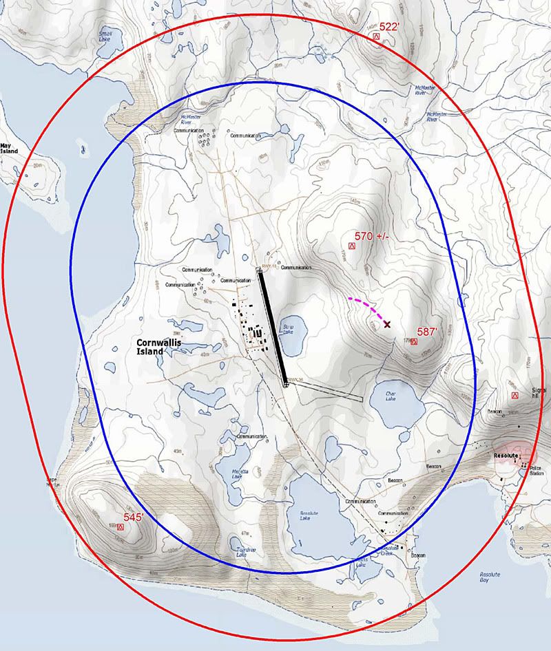
Published elevation is 67 meters/221 feet.
Aterpster's terrain map has a 70-meter contour line East of "Strip Lake".
Published elevation is 67 meters/221 feet.
Aterpster's terrain map has a 70-meter contour line East of "Strip Lake".
Last edited by Zeffy; 23rd Aug 2011 at 17:02. Reason: aterpster's map added

Join Date: May 2010
Location: EU
Age: 82
Posts: 5,505
Likes: 0
Received 0 Likes
on
0 Posts
BOAC, see link in post #56. There is now a new GoogleEarth picture, pointing out the location of the VOR vis-�-vis the impact site. Just for the picture - I am inferring nothing else.
Join Date: Jul 2004
Location: Found in Toronto
Posts: 615
Likes: 0
Received 0 Likes
on
0 Posts
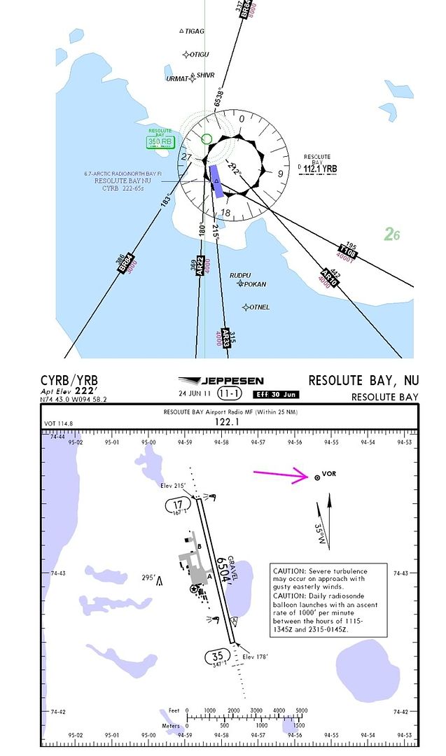
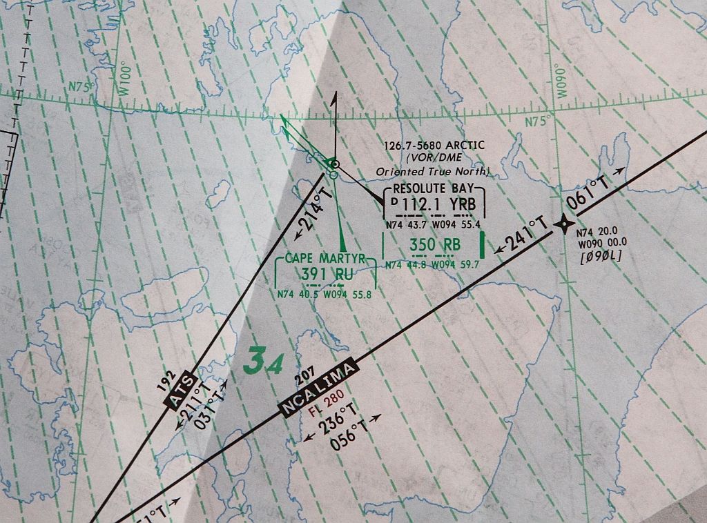
On the Jepp Canada 9-10 High/Low chart there are 5 different High Altitude Airways using the YRB VOR.
EDIT: It appears as though these airways are actually based on the RB NDB, but the charts seem to imply that they are co-located
Last edited by Lost in Saigon; 23rd Aug 2011 at 17:33.
Hmmm, it sounds indeed a bit like a weird possibility but maybe there is something to it.
The course matches scarily well. Elevation at crash site is ~500 - 550ft.
Elevation of airport is 197ft.
Distance between impact point and VOR is roughly 3/4 mile.
FWIW.
The course matches scarily well. Elevation at crash site is ~500 - 550ft.
Elevation of airport is 197ft.
Distance between impact point and VOR is roughly 3/4 mile.
FWIW.
Last edited by henra; 23rd Aug 2011 at 20:30. Reason: Elevation of Airport corrected accoring to chart
Join Date: Jul 2004
Location: Found in Toronto
Posts: 615
Likes: 0
Received 0 Likes
on
0 Posts
I don't think they were tracking to the VOR.
I flew in the Canadian "Bush" for many years. Old habits stay with you. I have trouble believing they would not have had the 2 NDB's tuned in to their ADF's to confirm their position. I still do this 30 years later if there are NDB's associated with the runway.
Like many others have said, I believe they were doing an ILS 35 circling for 17.
Join Date: Nov 2010
Location: Canada
Posts: 132
Likes: 0
Received 0 Likes
on
0 Posts
10 minutes after "3 mile final"
Three persons survived the crash, which evidently occurred as the aircraft was on an ILS/DME approach under a 200-foot cloud ceiling with three miles visibility in some fog and drizzle. The last radio communication with the aircraft occurred when it was approximately eight kilometres from the airport and the crash occurred 10 minutes later on a low hillside on line with the gravel runway.
Join Date: Jun 2001
Location: Chicago, IL, USA
Posts: 518
Likes: 0
Received 0 Likes
on
0 Posts
Originally Posted by Lost in Saigon
I don't think they were tracking to the VOR.
I flew in the Canadian "Bush" for many years. Old habits stay with you. I have trouble believing they would not have had the 2 NDB's tuned in to their ADF's to confirm their position. I still do this 30 years later if there are NDB's associated with the runway.
Like many others have said, I believe they were doing an ILS 35 circling for 17.
I flew in the Canadian "Bush" for many years. Old habits stay with you. I have trouble believing they would not have had the 2 NDB's tuned in to their ADF's to confirm their position. I still do this 30 years later if there are NDB's associated with the runway.
Like many others have said, I believe they were doing an ILS 35 circling for 17.
I agree with you and disagree with you.
I agree old habits stick with you and I do the same EXACT thing with NDBs, even in a glass airplane with a magenta line. It's just a habit.
But I have to admit, it's *feasible* they tuned the VOR, tracked the final app course for the ILS, couldn't get a GS so reverted to LOC mins and tracked that down to the MAP and tagged the hill on the way.
My question is, if they reported on the ILS for 35 and circled, why wouldn't they circle to the WEST out over the water? That would be my choice having never been there and just looking at the chart. Why would you circle towards the higher terrain?
Or maybe they did circle to the west and overshot final and ended up east of the field?
We still don't seem to have any agreement on the direction of flight...
Tragic, but I'm sure we'll all learn a good lesson.
I've read an AP article saying that there was a temporary military base set up 2KM from the crash site. Is there any chance they might have brought in equipment that could have complicated the navigation picture? I certainly hope not, but it seems just possible to my uneducated mind.
Join Date: Dec 1999
Location: Ottawa, Ontario, Canada
Posts: 330
Likes: 0
Received 0 Likes
on
0 Posts
BOAC,
It's just that I had the impression from your post that you felt a tailwind of >10 knots was too strong for a safe landing. I am quite sure that the crew of the ill-fated 737 had no concerns in this regard. If you fly strictly by the book in the Arctic you wouldn't get much done. The only safe approach to YRB in marginal weather is from the south, where you let down over the sea, line up with Rwy 35, cross the coast and arrive at the runway threshold with no obstructions to negotiate.
I don't wish to speculate on what the crew intended (I'm not qualified to do so in any case) beyond reiterating that I am quite certain they did not decide on a back course approach.

Join Date: Jan 2008
Location: Australia - South of where I'd like to be !
Age: 59
Posts: 4,261
Likes: 0
Received 0 Likes
on
0 Posts
Chu Chu
It was said early on that an Unannouced SIMULATED aircraft crash in the vicinity of Resolute was going to occur a couple of days after this tragic event occurred. Not sure if that temp base was part of this set up or other Mil ops that are occurring but I think everyone is thankful that so many military personnel and aircraft were at Resolute Bay.
It was said early on that an Unannouced SIMULATED aircraft crash in the vicinity of Resolute was going to occur a couple of days after this tragic event occurred. Not sure if that temp base was part of this set up or other Mil ops that are occurring but I think everyone is thankful that so many military personnel and aircraft were at Resolute Bay.
Guest
Join Date: Apr 2009
Location: On the Beach
Posts: 3,336
Likes: 0
Received 0 Likes
on
0 Posts
zerozero:
So the captain can have the sight picture.
My question is, if they reported on the ILS for 35 and circled, why wouldn't they circle to the WEST out over the water? That would be my choice having never been there and just looking at the chart. Why would you circle towards the higher terrain?
So the captain can have the sight picture.
There's a guy in the right seat who can update the captain on the turn progression. Never had a problem circling right from the left seat. This kind of wind is ideal. But you choose what you choose.
All speculation of course, but the VOR thing raises hairs on the back of my neck.
Last edited by OK465; 24th Aug 2011 at 02:04. Reason: forecast wind
Join Date: Jun 2001
Location: Chicago, IL, USA
Posts: 518
Likes: 0
Received 0 Likes
on
0 Posts
OK465, that's exactly how we would have done it in Alaska. The Capt can make a right hand circle with good participation from the the FO. After he negotiated the 545' foot obstacle to the west of the final for 35, it would really be a matter of following the shoreline downwind for 17 and hooking it in tight inside of the NDB.
I'd much prefer that than scud running to the east over rising terrain.
Just my honest opinion having circled for many, many years.
Very interested to see how this shapes up.
I'd much prefer that than scud running to the east over rising terrain.
Just my honest opinion having circled for many, many years.
Very interested to see how this shapes up.
Per Ardua ad Astraeus
Join Date: Mar 2000
Location: UK
Posts: 18,579
Likes: 0
Received 0 Likes
on
0 Posts
It looks like time to take a deep breath and re-establish known facts as many appear to be getting confused.
My understanding:
ILS 35 working, so why fly anything else if the wind is in limits? Anyone have the minima?
Why then, fly an approach on an en-route VOR with no published procedure?
Why then are folk talking about a BC17?
Only one NDB available - RB, north of the field.
The impact was nowhere near a circling track nor a localiser track.
If anyone has definitive contradictions please correct.
- you need to re-read my posts - I have not said "a tailwind of >10 knots was too strong for a safe landing." - I have said that 10 is the 'normal' limit. I do not know if this company had a 15. Your post implied that it was a 'done' that crews would ignore limits to get the job done. That is not unknown territory to me in military life, but it is potentially dangerous - it will work a lot of the time. Not all, and when someone pays to be safely carried one needs to think carefully before doing it and be prepared for the consequences. Aviation history is littered with bold aviators, not so many old.
Aterptser seems to think that a right-hand circle of an ILS 35 gives the captain 'the sight picture'??
My understanding:
ILS 35 working, so why fly anything else if the wind is in limits? Anyone have the minima?
Why then, fly an approach on an en-route VOR with no published procedure?
Why then are folk talking about a BC17?
Only one NDB available - RB, north of the field.
The impact was nowhere near a circling track nor a localiser track.
If anyone has definitive contradictions please correct.
Originally Posted by Rock
It's just that I had the impression from your post that you felt a tailwind of >10 knots was too strong for a safe landing.
Aterptser seems to think that a right-hand circle of an ILS 35 gives the captain 'the sight picture'??
Guest
Join Date: Apr 2009
Location: On the Beach
Posts: 3,336
Likes: 0
Received 0 Likes
on
0 Posts
BOAC:
Circling with the airport on the captain's side would be a left-land circle. That way he sees the airport. Depending on the competency of the F/O that may or may not matter.
On poster mentions that the clouds often tend to be lower over the higher terrain. In that case a right-hand circle would be better.
Aterptser seems to think that a right-hand circle of an ILS 35 gives the captain 'the sight picture'??
On poster mentions that the clouds often tend to be lower over the higher terrain. In that case a right-hand circle would be better.