


737 reported down in Canada

Join Date: Jul 2004
Location: Found in Toronto
Posts: 615
Likes: 0
Received 0 Likes
on
0 Posts
At those latitudes everything is done in TRUE so it is no more difficult than at any other latitude.
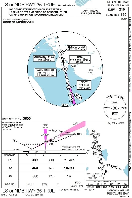
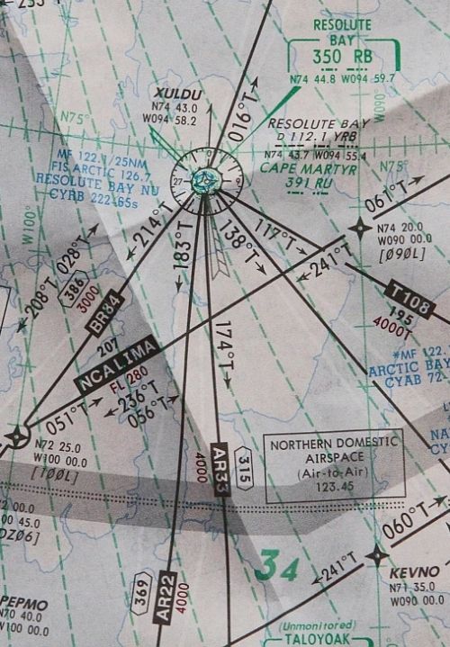
It is my understanding that even though it is not used for the ILS/DME 35T approach, the Cape Martyr NBD is still active. I would have tuned that NDB as well.
Here is an older approach:

Join Date: Jul 2004
Location: Found in Toronto
Posts: 615
Likes: 0
Received 0 Likes
on
0 Posts
When using 2 NDB's that are aligned with the runway (especially before and after the runway) you get a VERY accurate, simple to use, display of your position. Even in a crosswind.
Join Date: Jul 2004
Location: Found in Toronto
Posts: 615
Likes: 0
Received 0 Likes
on
0 Posts
Join Date: Jul 2004
Location: Found in Toronto
Posts: 615
Likes: 0
Received 0 Likes
on
0 Posts
I don't have access to current CYRB approach charts. But I have the latest High Altitude Enroute Charts.
Canada-Alaska 3/4 (eff May 2011) and Canada 9/10 (eff Mar 2011) both show the Cape Martyr NDB as active.

Guest
Join Date: Apr 2009
Location: On the Beach
Posts: 3,336
Likes: 0
Received 0 Likes
on
0 Posts
Lost in Siagon:
More so when one NDB is the final approach fix and the other is on the approach end of the runway, which used to be (may still be) common in eastern Europe. It does require two ADF receivers displayed on a slaved RMI. I don't know how that would work in a far north area of true navigation, unless the RMI card could be switched to true, which could be the case in current high-end airplanes.
When using 2 NDB's that are aligned with the runway (especially before and after the runway) you get a VERY accurate, simple to use, display of your position. Even in a crosswind.
Join Date: Jul 2004
Location: Found in Toronto
Posts: 615
Likes: 0
Received 0 Likes
on
0 Posts
Guest
Join Date: Apr 2009
Location: On the Beach
Posts: 3,336
Likes: 0
Received 0 Likes
on
0 Posts
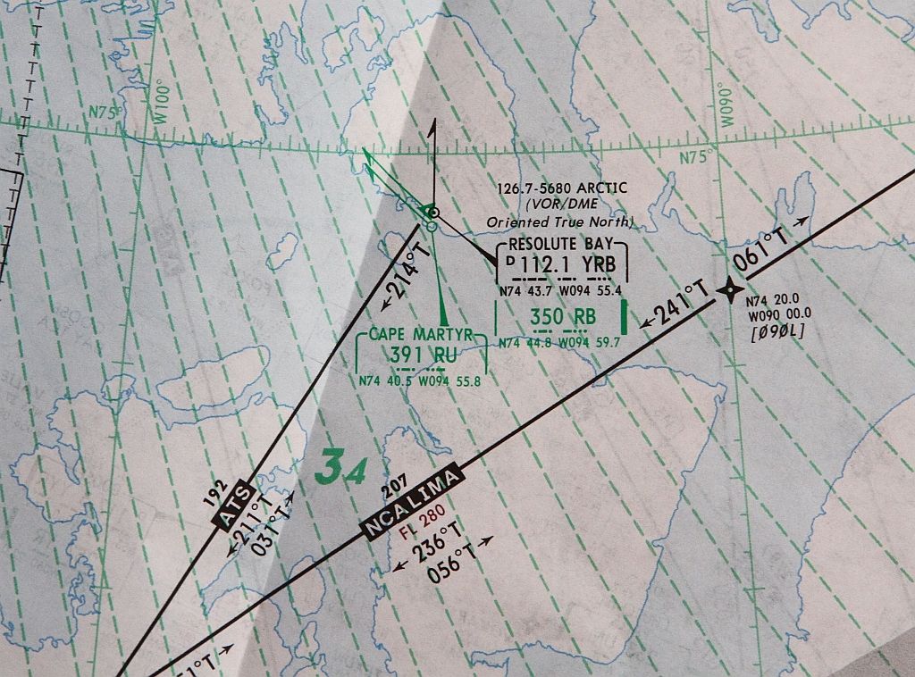
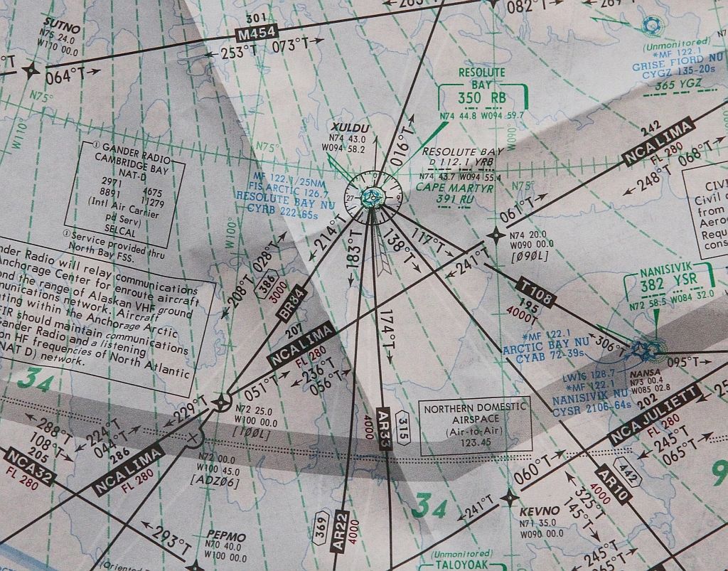
These are all of the current Jepp charts including snippets of the electronic low and high altitude charts. Note that the VOR supports no airways, low or high.
Index of /CYRB
Index of /CYRB
Join Date: Aug 2005
Location: Tennessee - Smoky Mountains
Age: 55
Posts: 1,602
Likes: 0
Received 1 Like
on
1 Post
QUJ
QTE
QDR
QDM
QFG
QFF
QNE
QNH
Are all these "Q's" only used in the UK? or Europe? Other than QNH and QFE, I have never heard of them before.
QTE
QDR
QDM
QFG
QFF
QNE
QNH
Are all these "Q's" only used in the UK? or Europe? Other than QNH and QFE, I have never heard of them before.
Join Date: Jul 2004
Location: Found in Toronto
Posts: 615
Likes: 0
Received 0 Likes
on
0 Posts
These are all of the current Jepp charts including snippets of the electronic low and high altitude charts. Note that the VOR supports no airways, low or high.
Index of /CYRB
Index of /CYRB
Those "snippets" seem to be drawn by someone how has little knowledge of actual airways. The VOR and tracks seem to be orientated in magnetic with incorrect headings.
Join Date: Jul 2004
Location: Found in Toronto
Posts: 615
Likes: 0
Received 0 Likes
on
0 Posts
ACP131 refers. You'll find them all listed in there. No idea whether they're supposed to be used by civil air traffic though!
Great resource. Thanks!
Guest
Join Date: Apr 2009
Location: On the Beach
Posts: 3,336
Likes: 0
Received 0 Likes
on
0 Posts
Little Saigon:
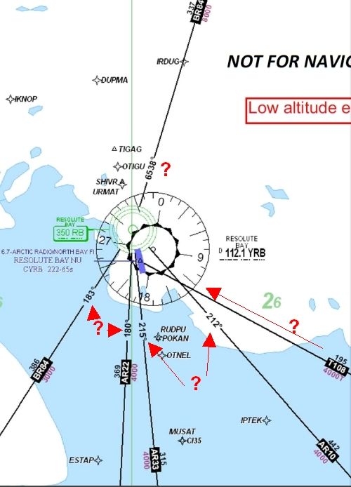
Obviously, the en route charts in JeppView are screwed up. Shame on them.
Following are low and high altitude en route charts from the iPad application Jeppesen Mobile FD. The FAA has approved this Jeppesen application as a replacement for paper charts on the Flight Deck.
I don't believe the electronic en route charts are quite ready for prime time, but the FAA seems to think so.
These are screen shots from my iPad, which is current. My client pays a lot of money for the Jeppview application and its derivatives.
Low altitude chart:
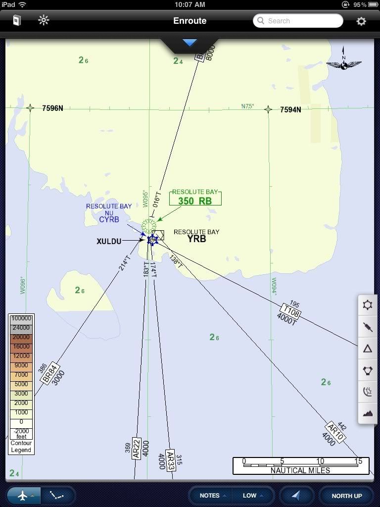
High altitude chart:
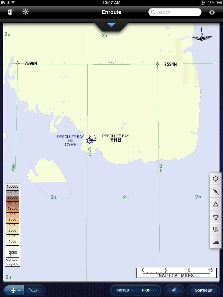
Obviously, the en route charts in JeppView are screwed up. Shame on them.
Following are low and high altitude en route charts from the iPad application Jeppesen Mobile FD. The FAA has approved this Jeppesen application as a replacement for paper charts on the Flight Deck.
I don't believe the electronic en route charts are quite ready for prime time, but the FAA seems to think so.
These are screen shots from my iPad, which is current. My client pays a lot of money for the Jeppview application and its derivatives.
Low altitude chart:
High altitude chart:
Join Date: Aug 2011
Location: between the lines
Age: 44
Posts: 16
Likes: 0
Received 0 Likes
on
0 Posts
The discussion may have moved on, but I'd like to review a bit what is known and what not really.
Some of the thoughts were centred around circling east and about an mistakenly chosen navigation source, mostly based on the debris trail.
The debris trail orientation is deduced from 1) the pictures of the crash site (avherald, post #8 mirrors the second) and 2) from the map view satellite images. Both sources are spatially referenced by the creek running down the hill and steps in the terrain. While there is no doubt the trail is generally running in a north-south direction, the uncertainty of the exact direction is considerable, owing to the individual errors:
a) Uncertain point of view: the pictures of the site are taken from further away, likely from the airport, the second appearing to be taken from a more southerly position. The second picture shows also small dots arranged left to right (RWY?), towards the depression that is probably the northern end of the lake. That would, if correct, position the camera approximately at the latitude of the apron. Uncertainty is on the order of hundreds of meters.
b) Zoom skew: picture one is apparently taken with a strong zoom factor. Any variation in depth (along line-of-sight component) would appear smaller than real, so that an oblique line would appear much more parallel to the image plane. There are some spectacular near-frontal shots of cross-wind landings that demonstrate this, where the aircraft appears only to crab as much as 45� to the runway. Effective uncertainty maybe 10 to 20�.
c) Definition of the "trail": the north end of the debris field appears wider than the south end. There are larger parts in front but the smaller parts stretch further to the W. If one chooses the bigger parts and the tail to define a line, it would slightly climb hillwards and move away from the camera towards the south (cf. b) ). One may as well prefer a triangle or a curved southern end. Uncertainty maybe another 15�.
d) Georeferencing: the creek and accentuated steps in the topography (likely geological bedding) are the visual references to link source 1 and 2. The first picture shows a small blue object where the northern of the two elongated snowfield on the satellite map would approximately be along a prominent step. The location of the impact site is quite well constrained, but the step retreats toward the creek. That makes it more difficult to map the trail.
All in all, if anybody can determine a trail direction more accurately than say �20�, then he is damn good (as a disclaimer, asked to draw a line, I would certainly do something similar like aterpstr on his map, maybe even tracking 300�). It seems mostly settled now, but the argument whether the track was parallel to the RWY or not, at least me, I simply couldn't answer, even less whether the last heading in the air before a (possibly oblique) impact was 347T or rather something else. (Even though SLF, I work in a profession where visual cues are important).
Similarly little is known about time, with an final call reported at 5 or 3 NM and apparently ~10 (�?) minutes before the fatal impact. None of this is reliable yet. Funny enough, the second most secure information after the location of the crash site is the general pre-impact attitude which was not extremely unusual, according to the recollection of a survivor which should at least be solid enough wrt extreme deviations.
Not to come with a grumbling "let's wait for more official facts", but being aware of how clues could possible fail in an assessment is always a step ahead.
Join Date: Jan 2009
Location: On a survey line somewhere...
Age: 42
Posts: 54
Likes: 0
Received 0 Likes
on
0 Posts
Not commenting other than to express my sincerest condolences to all involved, and awaiting the TSB's results.
From the thread on AvCanada at: AVCANADA • View topic - First Air Crash Resolute Bay August 20 2011
Yellowknife flypast:
YK Flypast - YouTube
From the thread on AvCanada at: AVCANADA • View topic - First Air Crash Resolute Bay August 20 2011
Yellowknife flypast:
YK Flypast - YouTube