


Chinook - Still Hitting Back 3 (Merged)

Join Date: Sep 2003
Location: Perth, Western Australia
Posts: 786
Likes: 0
Received 0 Likes
on
0 Posts
C240
So they stopped engines after moving to the terminal? Fuel critical flight, I think it was. Interesting.
Sycamore good stuff – I made the point a long time ago that there was not the right effort put into a rational analysis of the nav data, especially (as you too infer) that the nature of the crash could be navigation related; I go further and say why wasn't the CPLS acknowledged when its (mis) use explains their actions and the crash.
You mention waypoint “H” - if you go back some time in the posts, you'll find I had put in a link to a map with suggested a/c tracks on it – basically, I believe that Aldergrove to H then B gave a clear, safe LL route, handrailing up the coast of Islay/Jura – I suspect that H had been A but the Mull was added later (an excursion) with the intent to return to that safe route after Mull (H to B was 028 mag and the navigators HoSI was found with 028 on its course setting). H was simply an available letter after those used for Inverness.


Right then ,another anomaly;again from the Racal and Mitchell reports;
The Aldergrove QNH was given as 990 mb,Portree 990-991,and I believe as found on the a/c altimeters. The QNH input to the S-TANS is given as 998mb.
The derivation of the surface and altitude winds comes from an encoding altimeter ,fed to the S-TANS and modified by it`s QNH setting; the encoding altimeter gives a Pressure Altitude,based on 1013.25 mb,and then corrected using an algorithm,depending on altitude,but for our purposes 1mb= 29 ft.
Again assuming the ALDG/PORT QNH was pretty accurate , Sea-level pressure was 990mb,with a pressure altitude of 674 ft( ie 1013.25 datum was 674 ft below sea-level.
According to the reports Racal determined that the PA of the a/c at waypoint change was given as 900ft,which they worked out ,using the QNH set to give an a/c altitude of 468 ft. BUT,this was based on the set QNH of 998 mb.The difference between actual QNH is 8mb or 232 ft....
So ,if we take a PA of 900 ft,and a PA datum of -674 ft(below sea-level) we arrive at 230 ft above sea-level.
The Baro metric altitude according to Racal was 468 ft (above the 998 mb datum)(232 ft below sea-level).
That gives an altitude of 236 ft above sea-level ......
At power-down the PA is recorded as being 1100 ft; however this may have been affected by the actual crash conditions as the actual PA of the crash-site at 810 ft above sea-level should have been 810 +674 =1484ft.
However , there is a significant error in PA and it has been assumed that the aircraft had only climbed appx 200 ft or so in the time from the waypoint change to impact ,about 20 secs.
I assumed that the encoding altimeter for S-TANS is the main a/c one which would also possibly feed the TXPDR,or it maybe a separate one. Would anyone know if the instruments were examined in depth as part of the AAIB investigation ?
By my assumptions then,if the a/c was at about 240 ft at waypoint change,and crashed at 810 ft 20 secs later,it must have had a rate of climb of some 1710 ft/min,which according to the reports is extremely unlikely.
Now,I`m not a genius at maths(not even an `O`Level),so if I`ve got the sums wrong,please tell me,and any other answer...... Syc....
Join Date: Jan 2010
Location: High Wycombe UK
Posts: 52
Likes: 0
Received 0 Likes
on
0 Posts
Weather.........
BEagle...
I think this "often used" quote is actually someone's interpretation of the TAF for Machrihanish which really said.......
..there was a very similar actual from Machrihanish as well........
rgds Robin.....
The weather was suitable for the flight but would have required flight in accordance with IFR in the vicinity of the Mull of Kintyre
Among the TAFS was a forecast for Machrihanish issued at 1100GMT on 2 June 1994 and valid between 1400 and 2100GMT that day. The forecast wind direction was 130 degrees with a speed of 15 knots gusting up to 25 knots. The forecast visibility was 7,000 metres in haze with scattered cloud down to 1,200 feet and broken cloud down to 3,000 feet and temporarily throughout the forecast period visibility of 4,000 metres and broken cloud down to 500 feet. In addition it was said that there was a 30 per cent probability that temporarily during the forecast period there would be fog with visibility down to 500 metres and broken cloud down to 100 feet.
rgds Robin.....
Join Date: Sep 2005
Location: preston
Age: 76
Posts: 376
Likes: 0
Received 0 Likes
on
0 Posts
Sycamore and Robin,
Go back and read the many other entries on Weather and Altimeter.
The TAF is a forecast made several hours before. The Macrihanish actual shows the forecast was not widely off the mark.
In other words the crew made a perfectly legitimate and legal decision to attempt the flight.
The lighthouse observers and Mr Holbrooks reports are more relevant.
Again, several thousand entries ago, you will find that it was shown that the sub scale setting on the altimeter tied in with both LFP / Regional QNH, and LZ QFE.
Take your pick.
Dalek, I am not disagreeing with the weather conditions given by any of the witnesses; I merely suggested that there may have been other `factual` evidence in support,ie sat pics,auto wx.stations on the Mull. Neither did I suggest that it was not a viable VFR sortie. In fact I had flown past the Mull earlier in the day( about 25 miles East) on a low-level training sortie to Lossie; The Mull was visible but had a`Cap` of cloud over the highest point,rather like `lenticular cloud`.There was an upper cloud layer,but they did not merge.
Further,the QNH at Aldgve/Portree was given as 990 MB,and it was what was set on the a/c altimeters,no quibble about that.However,the setting ,input on the S-TANS was 998mb,a difference of 240 ft.That was clearly incorrect,but it may have been from earlier in the day,when the pressure may have been higher,or just an error. Some of the `displays `used are not always `user friendly`,and 8/0 can look similar in some light conditions.An honest mistake,but one that the `end result `,heights determined by Racal(again,in good faith) have been used by the Board ,Without checking to determine the outcome.
Further,since the aircraft had already flown earlier in the day,and a `snag ` had been reported ,but not logged in the F700,would it not have been `a good idea` to have checked the previous data from that earlier sortie as well ?. Maybe,it might still be in the Racal vaults ??
Using a pencil and graph paper it is easily possible to confirm my analysis of the heights .
Join Date: Sep 2003
Location: Perth, Western Australia
Posts: 786
Likes: 0
Received 0 Likes
on
0 Posts
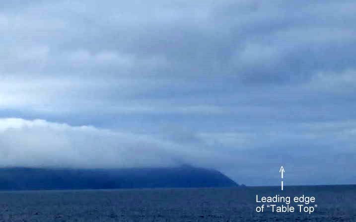
I took this shot from the north of the Mull when a gentle, steady wind was blowing – not enough for the “ground-hugging” mist to form.
This is classic orographic cloud and is quite common if you look for it.
The Mull slopes are ideal for its formation by virtue of their profile and their sticking into the sea with a prevailing wind onto them.
After an average summer's day, when the air cools towards evening and the prevailing wind is blowing, this type of oro cloud is just about guaranteed here and certainly could be relied upon days ahead with a favourable weather forecast.
It hides higher topographic features hindering orientation and casts a shadow on the slopes that hinders judgement of distance.
On the fateful day, the strong wind was causing a phenomenon termed “speed-up” whereby the lower layer of air is compressed, thereby speeding up and dropping in temperature, reaching its dew point in advance of the bulk of the airmass, and giving rise to a layer of mist that follows the slopes until it merges with the oro cloud higher up.
A person who was posted to guard the site was said to have commented that he was at the lower end of the site and his legs were in mist but he was in bright sunshine and was said to have said that he was surprised that he had not been called as a witness – pity he could not be persuaded to speak publicly.
The procurator fiscal (who called the FAI) himself who is a local and was at the crash site that evening described to me how the mist was layered like a cake with bright sunshine breaking through intermittently.
I have posted (years ago) a link to a video that shows its formation on the Mull – here it is again.
MullMistVideo video by grauniad - Photobucket
I took this video at the crash site but at a different time of year in conditions less benign to the formation of such mist such that it is seen forming higher up the slopes and very intermittently - however, demonstrates rather well, I think, how the appearance of the slopes is affected by such mist.
On the day, by all accounts, this up-slope mist started at the level of the light house and merged with the oro cloud at 800-900 ft – as the yachtsman (Mr Holbrook) described, some colour of the ground/lighthouse could be seen through the mist from where he was – but anyone used to coastal navigation in those conditions can tell you that, while you could be well aware of the presence of the landmass from even a great distance, the problem is that details on the surface are blurred/obscured such that judgement of distance off is very difficult whatever speed you are approaching it.
These conditions would be so typical in a summer late afternoon/evening that anyone interested in this crash could have gone up for a weekend (with the prevailing south westerly forecast) and seen it for themselves – why, after so many years, there is so much uninformed waffle is disappointing.
Last edited by walter kennedy; 5th Aug 2010 at 02:15. Reason: additional text
Thanks Walter,that`s similar,but as it was about midday it was brighter,higher ,but we were 25 miles East.
Join Date: Sep 2005
Location: preston
Age: 76
Posts: 376
Likes: 0
Received 0 Likes
on
0 Posts
I quite agree John Purdey. Anybody that flies a fully seviceable aircraft, deliberately across the Mull in those conditions, is a complete idiot and guilty of gross negligence.
Anyone who choses to ignore the evidence of of the Unit Test Pilot accepting instead the blatant untruths of Wratten and Day, passing off computer simulations as facts.
Is a complete idiot.
Anyone who choses to ignore the evidence of of the Unit Test Pilot accepting instead the blatant untruths of Wratten and Day, passing off computer simulations as facts.
Is a complete idiot.
Last edited by dalek; 6th Aug 2010 at 07:19.
Per Ardua ad Astraeus
Join Date: Mar 2000
Location: UK
Posts: 18,579
Likes: 0
Received 0 Likes
on
0 Posts
I think that is probably the first JP post with which I agree!
Now, I am confused here. Who are we talking about 'trying to fly over the Mull'? Is this a different accident?
Now, I am confused here. Who are we talking about 'trying to fly over the Mull'? Is this a different accident?
Join Date: Sep 2003
Location: Perth, Western Australia
Posts: 786
Likes: 0
Received 0 Likes
on
0 Posts
BOAC
Well said - there was no evident intent to overfly the Mull - they rattle off as though deliberately trying to hide the significance of these conditions - these conditions would only have presented a problem if they had for whatever reason a need to approach directly as the presence of the landmass would have never been hidden but judgement of distance to it to a useful degree would have been impractical - and in which case they would only have attempted such at speed with a local reference giving them accurate range - hence the interest in the CPLS and their apparent deliberate approach to a known LZ.
Regarding your query about the up-slope mist - the phenomenon is described in wind-farm studies (Google "wind farm" & "speed-up") - once you are aware of it you can see it quite often - here you can see a layer of mist close to the ground where the flow is around as opposed to up.
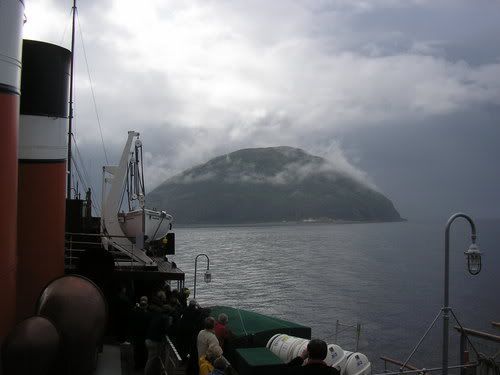
Ailsa Craig, for the record (don't know who took it) - when moist air is pushed against a sloping/curving surface the layer next to that surface is compressed, it then speeds up, drops in pressure, cools, and so condensation can occur in that layer next the surface while not yet in the bulk of the air mass moving around/up that obstacle.
Well said - there was no evident intent to overfly the Mull - they rattle off as though deliberately trying to hide the significance of these conditions - these conditions would only have presented a problem if they had for whatever reason a need to approach directly as the presence of the landmass would have never been hidden but judgement of distance to it to a useful degree would have been impractical - and in which case they would only have attempted such at speed with a local reference giving them accurate range - hence the interest in the CPLS and their apparent deliberate approach to a known LZ.
Regarding your query about the up-slope mist - the phenomenon is described in wind-farm studies (Google "wind farm" & "speed-up") - once you are aware of it you can see it quite often - here you can see a layer of mist close to the ground where the flow is around as opposed to up.
Ailsa Craig, for the record (don't know who took it) - when moist air is pushed against a sloping/curving surface the layer next to that surface is compressed, it then speeds up, drops in pressure, cools, and so condensation can occur in that layer next the surface while not yet in the bulk of the air mass moving around/up that obstacle.
Join Date: Sep 2003
Location: Perth, Western Australia
Posts: 786
Likes: 0
Received 0 Likes
on
0 Posts
sycamore
Despite some differences in appearance to your cloud, I hope that the two important properties of the orographic cloud and the up-slope mist are apparent to you now:
firstly, how the phenomena would affect visual perception of range to the landmass;
and secondly, that both phenomena are fixed to the feature that gave rise to them - it was not that they were travelling in an area where IMC may develop at any time but rather that they had to avoid hitting a fixed fuzzy object that for some reason or other they had approached directly and at speed.
Join Date: Apr 2005
Location: France 46
Age: 77
Posts: 1,743
Likes: 0
Received 0 Likes
on
0 Posts
Robin Clark
The quote regarding the forecast weather being "suitable for the flight but would have required flight in accordance with IFR in the vicinity of the Mull of Kintyre" was a quote from the Findings of the Investigating Board.
It is my belief that those words were used, after much consideration, in preference to the more condemnatory "but would have precluded flight in accordance with VFR in the vicinity of the Mull of Kintyre".

Join Date: Apr 2005
Location: France 46
Age: 77
Posts: 1,743
Likes: 0
Received 0 Likes
on
0 Posts
SFFP
The even bigger clue is the sworn evidence of the 2 Lighthouse Keepers (both trained Met Observers who routinely took meteorological observations as part of their Duties) who gave evidence to the BOI in respect of the actual weather on the Mull at the time of the crash.
Mr Murchie at the Lighthouse as the Chinook flew past overhead:
" I would estimate the visibility at this stage to be 15 to 20 metres at the most."
Mr Lamont driving to the Lighthouse from Campbeltown:
"The visibility, as I drove over the hill from Campbeltown to the lighthouse was down to only about 10 metres or less." The Chinook flew directly over Mr Lamont but he never saw it."
The Chinook impacted at approx 150 kts which equates to 77 metres/sec - however the aircraft was pitched nose up and yawing left in an apparent escape manoeuvre which would have reduced forward speed; thus the speed prior to that manoeuvre would have been greater than 150kts. It would be reasonable to say that the aircraft groundspeed was in the region of 80 metres per second which would have given only a quarter of a second visual warning at most prior to impact.
Further evidence was given by Mr Ellacott who was (ironically) looking for Aircraft accident sites who estimated that he was no more than 100 yards from the crash and the visibility was " nine or ten feet maximum."
