


AA5342 Down DCA

Joined: Jan 2015
Posts: 453
Likes: 467
From: Jupiter
This airspace literally has an intersection with crossing traffic designed into it. You can't hit something you're not close to.


Joined: Dec 2002
Aviation Qualifications: ATP+Mil
Posts: 3,985
Likes: 568
From: Where the Quaboag River flows, USA
The NYT link should work. It shows the helicopter v. Airplane traffic for the week (!) prior. There’s is no way in heck, that much helicopter traffic needs to be integrated with air carrier traffic. The govt hasn’t been in danger of continuity challenges in decades.
https://www.nytimes.com/interactive/...ane-crash.html
https://www.nytimes.com/interactive/...ane-crash.html


Joined: Oct 2000
Posts: 470
Likes: 6
From: Retired to Bisley from the small African nation
Sorry fdr, I humbly disagree. While it is near impossible to stop a light heli manually like a Robinson R22 without proper ground reference, those big junks used for all-weather rescue operations all have hover-capable autopilots. Press the button and the thing holds position even in strong winds. I am sure a Blackhawk has this feature too.
Joined: May 2005
Posts: 271
Likes: 145
From: Ontario, Canada
I guess - as the culprit here - I should clarify that I was wrong; both the VASAviation youtube video and the LiveATC recordings were two different radio channels spliced together, the helo was transmitting on a separate frequency.
The tower was transmitting on both frequencies - I believe - simultaneously.
So the CRJ would have heard only the tower's transmissions to the helo ('visual separation approved' x 2) and not the helo's transmissions.
The tower was transmitting on both frequencies - I believe - simultaneously.
So the CRJ would have heard only the tower's transmissions to the helo ('visual separation approved' x 2) and not the helo's transmissions.
It is not always understood on pprune (and again not you, mostly casual posters) that liveatc.net is just hobbyist / enthusiast stuff. It�s not reliable. The antenna placement is often poor, so some transmission sounds bad.
Same with using ads-b data from various sources and plotting tracks. Sometimes it is meaningful and sometimes the position is way too undersampled.
And don�t get me started on taking derivatives / differences on noisy undersampled signals to get things like wow look at that vertical speed here.

Joined: Feb 2013
Aviation Qualifications: ATPL
Posts: 154
Likes: 7
From: London
Speaking as someone who has been flying heavy metal into and out of the states for years, I find this accident obviously tragic but entirely unsurprising. I have had multiple instances of close calls with helicopters at various US airfields over the years down to completely inappropriate visual clearances being issued to the helicopter traffic - including clearances to fly under the active approach. On occasion helicopters appear to have taken it as almost a challenge to get as close as possible.. almost waving distance on one occasion at SJC. Apart from the risk of collision this is incredibly distracting for the crew of the other aircraft whose primary job at that point should be the monitoring of the flight path. Couple this with the practice of operating TCAS in TA only (as appears to be permissible in some instances for local US carriers) or indeed RAs being inhibited due to the low altitudes involved, and you have a recipe for disaster. Especially at night. And that is before we get on to the, all too often, casual level of R/T employed in the US.
Hopefully this event will spur a wider review of such practices rather than narrowly focusing on heli-lanes in the vicinity of Reagan.
Hopefully this event will spur a wider review of such practices rather than narrowly focusing on heli-lanes in the vicinity of Reagan.

Joined: Jan 2008
Aviation Qualifications: ATP+Mil
Posts: 122
Likes: 97
From: USA
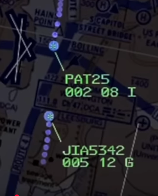
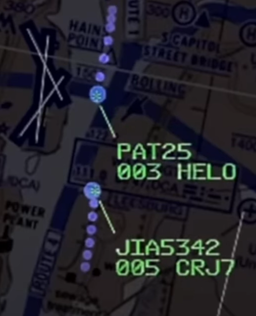
200 ft is not the separation between the 2 aircrafts, it's the maximum altitude allowed in the helicopter corridor. As the airplane on approach is supposed to be at about 250 ft when crossing this corridor, there is no way a 200 ft separation could ever have been achieved.
500' is also the VFR and IFR vertical offset standard. If unable to achieve, should not be allowed. 200' leg must be to be 500' below south flow DCA departures, so North flow arrivals need a better gate.
Joined: Jun 2009
Posts: 164
Likes: 13
From: UK
I've thought / made the same point. For a pilot in any way unfamiliar with the area the location of the other aircraft was given (however traditionally etc) in a way that would turn your head down to looking at Nav or Area charts for a few moments (And so not out of the correct window of the Heli at the last moments)
Joined: Feb 2019
Posts: 17
Likes: 21
From: New York
next of kin
DoD Instruction 1300.18 - Jan. 8, 2008
4.4.3. In cases where Service members or DoD civilian employees have been reported
DUSTWUN, EAWUN, or missing under potentially hostile situations, casualty information will
not be released to the media or the general public until 72 hours after the NOK has been notified
or the combatant commander clears the information for release.
[note, according to the news page on army.mil, the soldiers' status is DUSTWUN ]
https://www.esd.whs.mil/Portals/54/D...di/130018p.pdf
Joined: Nov 2017
Posts: 12
Likes: 1
From: USA
A red collision alert was flashing at this point on the controllers screen, the instruction should�ve been for the CRJ to go around, not wasting time on the helicopter pilots.
Secondly, why shouldn�t we criticise the controller? Imho his actions need to be criticised. Not the individual but the environment, procedures and training he operated in. The mission of ATC is to prevent exactly this from happening and they failed in their mission.
Secondly, why shouldn�t we criticise the controller? Imho his actions need to be criticised. Not the individual but the environment, procedures and training he operated in. The mission of ATC is to prevent exactly this from happening and they failed in their mission.
Absolutely on the lookout.
No the airspace does not take the blame. Apparently the hello pilots missed the lookout. And the controller could have been clearer, instead of �still in sight?� perhaps �the RJ is now 1/2 mile 10 o�clock, confirm you have him?�.
(not criticizing him, guessing that he saw them closer than expected, was concerned, and made a very quick call)
But the airspace & procedure seems to not tolerate mistakes. There ought to be some safety margin. While not the primary fault, it could be improved.


Joined: May 2002
Aviation Qualifications: ATP+Mil
Posts: 18,633
Likes: 1,072
From: Downeast
RTFQ here folks....slow down and actually read the question.
Pattern, perhaps you might review your comment.
It really is not a difficult concept or question.
Seems easy enough to understand if the post is actually read for comprehension sakes.
Now a test question for him.....were you flying the incident airplane doing a Visual Approach to RWY33....would you have tuned up the IAP for that RWY as an additional reference for your approach?
SOP's usually instruct Crews to use ILS data when doing Visual Approaches to runways with that kind of IAP so would that kind of thinking apply in this incident? Would that have been of any benefit considering the existing weather and terrain? Or, would that have been a distraction?
SOP's usually instruct Crews to use ILS data when doing Visual Approaches to runways with that kind of IAP so would that kind of thinking apply in this incident? Would that have been of any benefit considering the existing weather and terrain? Or, would that have been a distraction?
It really is not a difficult concept or question.
Seems easy enough to understand if the post is actually read for comprehension sakes.
Joined: Oct 2006
Posts: 148
Likes: 98
From: Canada
From the radar pics below might the helo pilots have their attention outside of the cockpit searching for the traffic, with no one minding the store (instrument scan break down) they unwittingly climb a 100 feet from their previous 200 feet. Also they are not tracking the helo lane on the rivers east bank. There are times when an auto pilot can earn its keep (altitude maintenance whilst attention is diverted).
Sounds like that might cause a lot more accidents than it would solve.
Joined: Jul 2013
Aviation Qualifications: CPL
Posts: 611
Likes: 474
From: Maryland USA
Some folks here need to read back through the thread before posting.
The helicopter crew is said to have had NVG's but at this point no information has been provided re their use of NVG's.
The height issue is not the primary issue as the intent of the procedures and ATC instructions was to separate the two aircraft.
Had that separation effort worked there would have been no conflict thus no collision.
It is the failure of the separation and the meeting over the river the two aircraft in the same bit of air that height mattered.
No where in the standard procedure was it intended to have helicopter traffic fly below landing aircraft on RWY 33.
Poll the Pilots here folks....ask them if they would routinely fly 100-200 feet below a crossing aircraft? What do you think the answer would be?
I thank 212 Man for his input reminding me why he was the Teacher's Pet. I depend upon his ability to get into the books to keep me straight.
Now a test question for him.....were you flying the incident airplane doing a Visual Approach to RWY33....would you have tuned up the IAP for that RWY as an additional reference for your approach?
SOP's usually instruct Crews to use ILS data when doing Visual Approaches to runways with that kind of IAP so would that kind of thinking apply in this incident? Would that have been of any benefit considering the existing weather and terrain? Or, would that have been a distraction?
This was not a "Circling Approach" but it was very similar.
Joined: May 2010
Posts: 1,571
Likes: 374
From: PLanet Earth
It hasn't necessarily climbed 100 feet. sinc display resolution is only 100ft it could be that it climbed from 240 to 260ft between these two screens. Besides this it also shows how ludicrous this 100ft vertical separation in this case was. Even the ATC screens resolution do not really support this level of separation. 245ft would still have shown as 002 and if in the middle of the Potomac the 3� G/S would be already lower than this.
Joined: Jul 2013
Aviation Qualifications: CPL
Posts: 611
Likes: 474
From: Maryland USA
Re hovering on the helicopter routes: Perusing some forums where Army pilots post several of them recounted being told to go hover over X point while traffic cleared at DCA. Not all controllers seem willing to run traffic as close together as this one did.
Joined: Jan 2008
Posts: 17,724
Likes: 2,093
From: Reading, UK
Also, Reuters:
"Defense Secretary Pete Hegseth said the helicopter was flown by a "fairly experienced crew" of three soldiers who were wearing night-vision goggles on an annual training flight."
Joined: May 2002
Aviation Qualifications: ATP+Mil
Posts: 18,633
Likes: 1,072
From: Downeast
Island,
Thank you....figured that would be the answer especially if the runway change is very close in to the Airport.
Dave,
The video Clip I saw of Hegseth he noted the Crew "had" them then stated it had not been confirmed they were "using" them.
That was last night sometime I saw that on the Re-Run Stream channel I had on that draws from multiple sources.
Also....the NTSB guy said much the same thing saying the Investigation in time would try to determine that.
I trust the video and my lip reading ability over the media anymore.
I just did a google search and found this video clip that has Hegseth talking about the Mid-Air Collision and he clearly states the case as I described it.
About one minute into the video Hegseth addresses NVG's.
Last edited by SASless; 1st February 2025 at 16:28.

Joined: Sep 2018
Posts: 199
Likes: 41
From: Laredo, TX
A red collision alert was flashing at this point on the controllers screen, the instruction should�ve been for the CRJ to go around, not wasting time on the helicopter pilots.
Secondly, why shouldn�t we criticise the controller? Imho his actions need to be criticised. Not the individual but the environment, procedures and training he operated in. The mission of ATC is to prevent exactly this from happening and they failed in their mission.
Secondly, why shouldn�t we criticise the controller? Imho his actions need to be criticised. Not the individual but the environment, procedures and training he operated in. The mission of ATC is to prevent exactly this from happening and they failed in their mission.
Joined: Jun 2001
Aviation Qualifications: ATPL
Posts: 4,087
Likes: 4,429
From: 3rd Rock, #29B
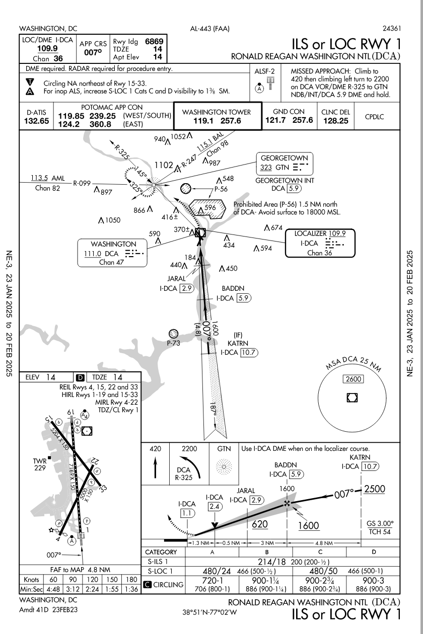
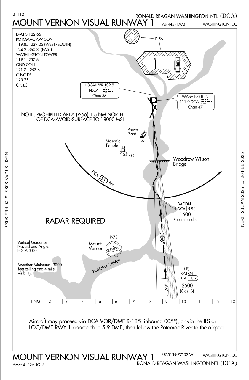
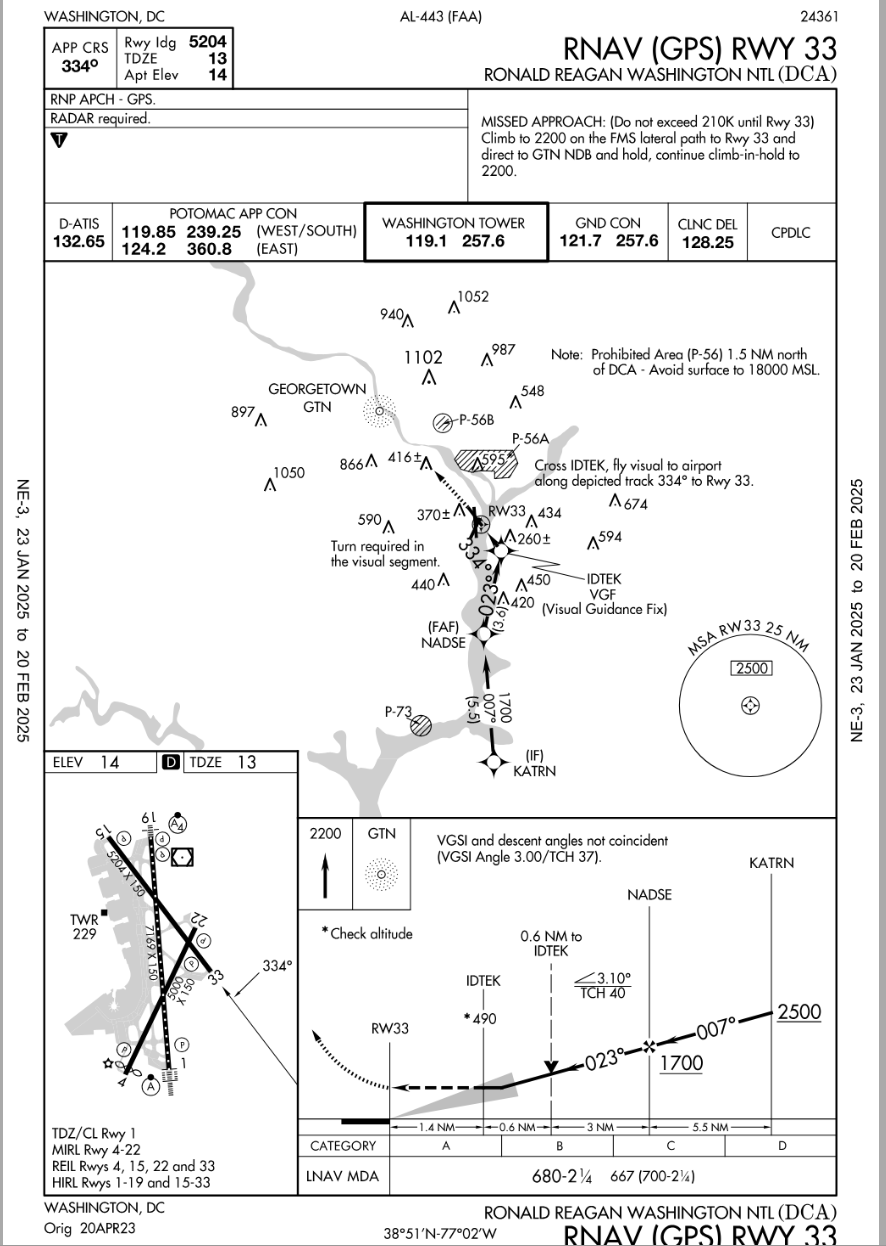
There IS NO ILS for runway 33 at KDCA. The only ILS at KDCA is for runway 1.
There is a curving RNAV approach, that is not in line with the runway until 490 feet/1.4nm, where one makes the last-minute ~50� left turn for visual runway alignment.
In light of that fact, maybe you can reframe your question.
AirNav: KDCA - Ronald Reagan Washington National Airport
https://aeronav.faa.gov/d-tpp/2501/00443R33.PDF
RTFQ here folks....slow down and actually read the question.
Pattern, perhaps you might review your comment.
It really is not a difficult concept or question.
Seems easy enough to understand if the post is actually read for comprehension sakes.
Quote:
Now a test question for him.....were you flying the incident airplane doing a Visual Approach to RWY33....would you have tuned up the IAP for that RWY as an additional reference for your approach?
SOP's usually instruct Crews to use ILS data when doing Visual Approaches to runways with that kind of IAP so would that kind of thinking apply in this incident? Would that have been of any benefit considering the existing weather and terrain? Or, would that have been a distraction?
Pattern, perhaps you might review your comment.
It really is not a difficult concept or question.
Seems easy enough to understand if the post is actually read for comprehension sakes.
About 80% of all IATA operators would be discomforted by such changes, outside of the USA visual approaches at night have a litany of requirements to adhere to for the purposes of terrain separation, vs Texas big sky rules that do work in the US. In the end, taht didn't cause the accident, it is one of those things that goes with the freedom of flight in the USA.
...
Joined: Feb 2019
Posts: 17
Likes: 21
From: New York
local helo
Are there any non-local pilots flying that route?
I have only once flown into the Washington area, and it was more than a decade ago in a light single. I seem to recall DCA required special training even for airline pilots.
Is that not the case now or not for helicopter pilots? I thought it was a case where you need to be familiar to use those routes.
I fly in the DC FRZ and you hear the helo folks on freq all day, ( a lot of Coast Guard, various DoD, various fed LEO, some medivac and lifeguard) and they all know every inch of the area. Also surprising to listen to is that helo pilots through the FRZ are pretty much self-directed and entrusted with self sufficiency that fixed wing traffic is not. They've all been vetted, fingerprinted, have their own squawks etc and so ATC gives them a lot of respect. They announce intentions to 'fly route X' or 'request direct Andrews', and ATC is able to understand their intentions and clears a path and approves - and then you don't hear a peep from them until they reach the endpoint - then they announce next intention like "Field in sight'" -> "contact Andrews tower on..., Freq change approved" -> "good day" and the whole 20 minutes had a total of three radio calls..
They seem to all know what they're doing and it's nobody's giving off the vibe that it's any kind of initial training for anything - you don't hear ATC having to telling them to 'say altitude' or 'turn left 10 degrees' or really anything, and you don't hear the pilots giving half arsed requests. [This level of trust might have had consequences, but I'll defer my judgement]
For all helo pilots local knowledge is a survival. Lots of civi helos in DC are based out of KFME, and the ones I know every inch of territory, every local landmark, overpass, bridge, body of water within the DC beltway like the back of their hand - one guy knows off the top of his head if every single road is asphalt or concrete, light or unlight, etc. Similar experience when I met news chopper folks based in the Valley - they knew hundreds of places in greater Los Angeles that I never even heard of.
Landmarks in DC are hard to miss, basically every one knows where the WW bridge, Hanes Point, the route of the Potomac, etc.. DCA is strangely popular for plane watching (there's rec areas to view at each end) so an absurdly large number of non-av people in the area are familiar with how the traffic flow works. I kayak right below the crash area and when wind is out of North, you can see landing lights of 7+ sequenced arrivals coming up the Potomac, it's basically impossible to miss the incoming landing parade and even non-av people get the concept. The WW bridge would seem to me a good point of reference for a callout, everybody knows where to immediately look. It's hard to think that the IP didn't understand local reference of the ATC traffic advisory.