


AF 447 Search to resume

Join Date: May 2010
Location: SW from BUD
Age: 53
Posts: 1
Likes: 0
Received 0 Likes
on
0 Posts
may 6 - 12 seach zone
I'm new here, and also not having any sonar experience, just some basics in acoustics. I overthought the may 6 - 12 "navy_search" and based on this drafted a small extended search zone, maybe someone more experienced comment on this. ( I think that the french navy's signal detection has more precise position compared to the backdrifted vertical stabilizer, just some interpretation is missing from the results ).
the following contains a lot of guesses:
- first guess ( may be ruled out by navy ): the navy used a signal processing which traded in directional sensitivity for signal to noise ratio, to rise the signal above background noise, this way the direction information was lost, they could only tell the location of Emeraude where the signal could be rised from background noise. Based on this, probably line shape, BEA made a search zone in the long axis of this position with a few nautical mile border. In this case the highest signal level probably was detected, with the Emeraude in the center of the navy_search_zone.
- the search in this zone found nothing, but if the navy could pesuade BEA to look there, then the detection had to be strong enough, but if nothing was there then the signal maybe travelled there on other ways. The attenuation of the pinger signal on this frequency doesn't allow direct detection from great distances sideways from the ocean bottom. my guess is: a natural amplifier had to amplify the signal to be detectable from greater distance.
- the vertical center of the sofar channel, based in the june 6 BEA celerity data, was in 700 - 900 m depth
- as far as I know sofar channel entered sound reaches specific depth in more or less circular patterns/spots, the attenuation in horizontal distance, and the max height reached during propagation depends on incident angle of the sound, a relatively shallow incident angle causes sound to propagate further, but not reaching high enough, a close to vertical incident angle enables reaching the surface but not propagating horizontally.
- there is an underwater mount ( red in bathymetry ) North-East from the supposed Emeraude position, if the color code is identical with the earlier published BEA bathymetry scale, then the top of the mountains are in the middle, middle-bottom of the sofar channel.
- the South-West side of this mountain is very steap, and three few nm sized parabolic like shapes may be identified on it.
- my guess is: a pinger located around the verical focal plane of these parabolas on the ocean bottom could concentrate the pinger signal into
the sofar channel, the incident angle beeing not horizontal, the signal travelled in the sofar channel with larger vertical swings, and one of these swings reached Emeraude.
Emeraude could detect it only at the place where the upper peaks in the channel were, and because swing length can be significant, maybe this was the first place from the mountain, or maybe further places can be identified with the same processing which was done with sonar data ( but if the Emeraude track distance was not enough fine, during the first search, then further refinement may not be made ).
I don't say that these shapes are perfectly formed parabolas, in the need of acoustic reflections ( if I estimate correctly then pinger wavelength is around 4 cm ) but may contain alligned surfaces wich concentrate waves.
I think I would take a look at S-W from the mountain, where the base of the perpendicular from the Emeraude highest detection position to the mountain is.
- if the wreck is there then the mountain blocked any signals into the direction of the largest part of the search zone
- there is a wide flat bottom area, between the Emeraude and the mountains, which may helped the propagation.
- if the pinger had been located on top of the mountain in 800 - 1000 m depth then it could also penetrate the sofar channel, but then it had to be heard from other positions also.
- if the pinger had been located further to the N-E direction then the mountain would block at least partially the sofar channel, preventing it to reach Emeraude in the middle of the navy_search area.
- the published diving depth for the french rubis class submarines are 300 m, and if the published rating is "low profile" then it could be in a depth of 400 - 500 m-s which made it possible to pick up the pinger signal.
Further bathimetry, west from the navy_search_zone was not done, but if similar sea mounts are present west of it but close to the navy search zone,
I would look there also.

I made this simple drawing based on the BEA bathymetry, I would search the yellow bordered area, and if I had time constraints I would take a look at least at the middle and the south-east one of the three parabolic shaped formations.
the following contains a lot of guesses:
- first guess ( may be ruled out by navy ): the navy used a signal processing which traded in directional sensitivity for signal to noise ratio, to rise the signal above background noise, this way the direction information was lost, they could only tell the location of Emeraude where the signal could be rised from background noise. Based on this, probably line shape, BEA made a search zone in the long axis of this position with a few nautical mile border. In this case the highest signal level probably was detected, with the Emeraude in the center of the navy_search_zone.
- the search in this zone found nothing, but if the navy could pesuade BEA to look there, then the detection had to be strong enough, but if nothing was there then the signal maybe travelled there on other ways. The attenuation of the pinger signal on this frequency doesn't allow direct detection from great distances sideways from the ocean bottom. my guess is: a natural amplifier had to amplify the signal to be detectable from greater distance.
- the vertical center of the sofar channel, based in the june 6 BEA celerity data, was in 700 - 900 m depth
- as far as I know sofar channel entered sound reaches specific depth in more or less circular patterns/spots, the attenuation in horizontal distance, and the max height reached during propagation depends on incident angle of the sound, a relatively shallow incident angle causes sound to propagate further, but not reaching high enough, a close to vertical incident angle enables reaching the surface but not propagating horizontally.
- there is an underwater mount ( red in bathymetry ) North-East from the supposed Emeraude position, if the color code is identical with the earlier published BEA bathymetry scale, then the top of the mountains are in the middle, middle-bottom of the sofar channel.
- the South-West side of this mountain is very steap, and three few nm sized parabolic like shapes may be identified on it.
- my guess is: a pinger located around the verical focal plane of these parabolas on the ocean bottom could concentrate the pinger signal into
the sofar channel, the incident angle beeing not horizontal, the signal travelled in the sofar channel with larger vertical swings, and one of these swings reached Emeraude.
Emeraude could detect it only at the place where the upper peaks in the channel were, and because swing length can be significant, maybe this was the first place from the mountain, or maybe further places can be identified with the same processing which was done with sonar data ( but if the Emeraude track distance was not enough fine, during the first search, then further refinement may not be made ).
I don't say that these shapes are perfectly formed parabolas, in the need of acoustic reflections ( if I estimate correctly then pinger wavelength is around 4 cm ) but may contain alligned surfaces wich concentrate waves.
I think I would take a look at S-W from the mountain, where the base of the perpendicular from the Emeraude highest detection position to the mountain is.
- if the wreck is there then the mountain blocked any signals into the direction of the largest part of the search zone
- there is a wide flat bottom area, between the Emeraude and the mountains, which may helped the propagation.
- if the pinger had been located on top of the mountain in 800 - 1000 m depth then it could also penetrate the sofar channel, but then it had to be heard from other positions also.
- if the pinger had been located further to the N-E direction then the mountain would block at least partially the sofar channel, preventing it to reach Emeraude in the middle of the navy_search area.
- the published diving depth for the french rubis class submarines are 300 m, and if the published rating is "low profile" then it could be in a depth of 400 - 500 m-s which made it possible to pick up the pinger signal.
Further bathimetry, west from the navy_search_zone was not done, but if similar sea mounts are present west of it but close to the navy search zone,
I would look there also.
I made this simple drawing based on the BEA bathymetry, I would search the yellow bordered area, and if I had time constraints I would take a look at least at the middle and the south-east one of the three parabolic shaped formations.

Join Date: Nov 1999
Posts: 324
Likes: 0
Received 0 Likes
on
0 Posts
About time for the World's regulators to Start Thinking about this Type Measure
STAR NAVIGATION INTRODUCES THE WORLD'S FIRST REAL-TIME IN FLIGHT SAFETY MONITORING SYSTEM AND THE IDEAL COUNTERPART TO THE "BLACK BOX"
Star Navigation Systems Group Ltd., a recognized leader in the aerospace safety and monitoring industry, is proud and excited to announce the introduction of THE WORLD'S FIRST REAL-TIME IN FLIGHT SAFETY MONITORING SYSTEM ISMS� the ideal counterpart to the "black box" and a quantum leap in aerospace safety technology!
Most people are familiar with the "black box", the near indestructible sealed recording device that assists investigators in determining the cause(s) of an aircraft accident. What isn't as well known is that not only are black boxes not the complete solution, by their very nature they are designed to indicate problems AFTER they have already occurred - much too late to help the pilots and passengers. In cases such as the Air France Flight 447 disaster earlier this year, the airplane's black boxes sank to the ocean floor and have never been recovered; despite a massive search the cause of that terrible tragedy remains somewhat of a mystery. It's obvious that a real-time counterpart to traditional black boxes is needed and Star Navigation has answered the call.
Star Navigation's In Flight Monitoring Service first introduced in 2005, was a quantum leap ahead in aerospace safety and monitoring technology. It performed all the functions of black boxes while providing current information to pilots and ground controllers, giving the ability to note any anomalies and to nip problems in the bud. The improved STAR-ISMS� In Flight Safety Monitoring System provides both real-time and after-landing reports, intelligent flight data transmission, plus more detailed live flight data alerts through the efficient use of leading edge satellite-based technology.
One of the main features of the new STAR-ISMS� is its built in GPS tracking software built-in GPS tracking software that enables more accurate tracking of an equipped airplane to the last known latitude, and longitude. It also boasts improved accuracy and the ability to instantly provide an aircraft's exact altitude, heading and airspeed.
The essential avionics and diagnostic information collected by the STAR-ISMS� is transmitted at operator defined intervals or triggered events, via satellite, to ground-based installations in real time regardless of weather conditions. As well, Star's on-board hardware and software will independently analyze all selected incoming sensor & systems data and compare it with normal parameters - any deviation is noted and an alert is sent out if necessary. In the event of multiple failures, the automated "Mayday" feature commences an immediate �data dump�, sending as much information as bandwidth will allow. It can be said that STAR-ISMS� opens a "virtual window" into the in-flight operation of a commercial aircraft.
The utility of the improved STAR-ISMS� doesn't end once a plane has landed. All monitored in-flight data is recorded and stored for later review, and detailed reports are automatically generated, providing operators with useful information that can be used to streamline procedures and institute economies on future flights. These detailed reports are created mere minutes after an aircraft lands. One especially noteworthy feature of the STAR-ISMS� is that the information it notes and records can be used by airline ground crews to plan maintenance scheduling, monitor aging equipment, even predict the possibility of hardcore failure due to material stress and fatigue. In effect, the STAR-ISMS� acts as an "early warning system" for a host of potentially catastrophic equipment failures while reducing the frequency of expensive and time-consuming unscheduled maintenance and passenger delays.
Star Navigation has never been content to rest on its laurels and the Company continues to develop future applications for this valuable technology. With that in mind, the STAR-ISMS� has been designed to be fully upgradable so that operators can improve their safety and monitoring capabilities while boosting operational efficiencies.
While the next-generation safety and monitoring technology featured in the STAR-ISMS� In Flight Safety Monitoring System is not meant to replace airline black boxes, its use alongside them adds an extra level of safety that can be counted on to save time, money, and most importantly lives.
The STAR-ISMS� In Flight Safety Monitoring System uses proprietary, patented Canadian technology and Star owns the exclusive world-wide license to this technology. Certified by Transport Canada and the Federal Aviation Administration, STAR-ISMS� has been extensively tested and fully developed during normal commercial aviation settings and is now ready for deployment on the world's aviation fleets!
ABOUT STAR NAVIGATION
Star Navigation Systems Group Ltd. is a leading edge technology company focused on providing Aerospace Solutions - both hardware and software platforms - to assist aviation operators worldwide. Star has developed the STAR-ISMS� In-Flight Safety Monitoring System - the first system in the world to feature in-flight data monitoring and diagnostics with a real-time, secure connection between aircraft and ground. The STAR-ISMS� is the ideal counterpart to the "black box" and an essential safety feature for the world's passenger and commercial aircraft. For more information on Star Navigation, please visit the company website at Star Navigation Systems Group - Home
*based upon an original 1998 concept (Iridian-Roadshow) at http://tinyurl.com/kv2owv
Join Date: Jun 2009
Location: in a plasma cocoon
Age: 53
Posts: 244
Likes: 0
Received 0 Likes
on
0 Posts

Jeff
PS) The BEA seems to consider that there is no wreckage to the south of the LKP:
�Il n'y a jamais eu d'AF 447 au sud, nous avons perdu une semaine� (Le Figaro)
�Nous avions un choix � faire, nous l'assumons, le choix �tait d'utiliser les quelques jours qu'il nous restait pour suivre notre programme plut�t que de rester dans une zone o� nous pensons que la probabilit� de retrouver l'�pave est relativement faible� (M. Le Troadec in "Le Point")
Last edited by Hyperveloce; 25th May 2010 at 16:19. Reason: Precision about the BEA/Navy-MoD controversy
Join Date: May 2010
Location: MA, USA
Posts: 126
Likes: 0
Received 0 Likes
on
0 Posts
Reports about the end of the search are starting to appear:
Air France 447 Crash Hunt Ends With Areas Unexplored (Update1) - BusinessWeek
Air France 447 Crash Hunt Ends With Areas Unexplored (Update1) - BusinessWeek
Quote from iabel:
"I would search the yellow bordered area, and if I had time constraints I would take a look at least at the middle and the south-east one of the three parabolic shaped formations."
As it's in the SW quadrant, and has not yet been covered (though very nearly), why not?
Parabolic reflecting faces are something even we simple mortals can understand.
But has the Seabed Worker already passed the area, perhaps, en-route Recife?
Chris
Join Date: Jun 2009
Location: Florida
Age: 60
Posts: 26
Likes: 0
Received 0 Likes
on
0 Posts
Out of curiosity, does anyone have any idea about how emphatic the BEA can be when they say that the Seabed Worker has not found anything? Presumably the side scan sonar recordings made by the AUVs will subject to further reviews onshore in case the initial viewings have missed something?
Hopefully before the next search phase in the autumn (Figaro article) the BEA and the french navy will get their acts together to better understand and interpret the Emeraud's recordings - if they really did "hear" the AF447 pingers then this should allow a better targetted search than the current crop spraying approach.
Hopefully before the next search phase in the autumn (Figaro article) the BEA and the french navy will get their acts together to better understand and interpret the Emeraud's recordings - if they really did "hear" the AF447 pingers then this should allow a better targetted search than the current crop spraying approach.
BEA and the french navy will get their acts together to better understand and interpret the Emeraud's recordings
I'm not sure who are the known underwater acoustics powerhouses are - but it would seem worthwhile having another set of experts analyze the data and see if they can independently come up with other suggestions - I'm suspicious though that would be prevented due to national security concerns. Thoughts?
- GY
Join Date: Jul 2009
Location: France - mostly
Age: 84
Posts: 1,682
Likes: 0
Received 0 Likes
on
0 Posts
What next?
Hyperveloce;
thanks for your reply #1161, and in particular to your PS referencing 'Le Point'. Some highlights of that article may interest others on this thread:
Phase 3 has ended without success. The ship is on its way to the port of Praia in the islands of Cabo Verde. Equipment and crew have to be demobilized may 27th. Decision regarding a new search phase has not been taken, and is not in the hands of BEA alone. BEA needs at least one or two months to take stock, together with its partners, of all search operations started almost a year ago, and eventually take a decision to continue the search.
Join Date: Jun 2009
Location: NNW of Antipodes
Age: 81
Posts: 1,330
Received 0 Likes
on
0 Posts
Update: "Seabed Worker" - position
The Seabed Worker departed the Zone 2 search area for Praia, Cape Verde Islands at about 24/1930z and at 25/0635 was at 5�31'36''N 29�20'32''W Hdg 028.6�T Spd 13.0 knots.
---------------------
I think you may have misinterpreted what was going on. The Navy conducted tests using another Rubic class submarine to optimise the sensitivity of the sonar receiver to 37.5kHz. I seem to remember reading that the SNA fleets sonars operated at a nominal 18kHz, and following the adjustment, the mod details were relayed to the Emeraude, which from 01 July to 10 July operated in the optimised mode.
The Thales re-examination of the tapes recorded by the Emeraude used other techniques to extract 37.5kHz data hidden in the background noise.
mm43
---------------------
originally posted by HN39 ...
In other words, the tapes obtained in the mediterranean were dated before July 1st.
In other words, the tapes obtained in the mediterranean were dated before July 1st.
The Thales re-examination of the tapes recorded by the Emeraude used other techniques to extract 37.5kHz data hidden in the background noise.
mm43
Join Date: Jan 2002
Location: USA
Posts: 286
Likes: 0
Received 0 Likes
on
0 Posts
I have read both threads since they began, but I do not remember seeing any comment regarding which and how many navy subs were used. GB, French, and US are probably givens. Were any Russia subs used. Some Russian boats, with their super tough titanium hulls (as opposed to the steel hulls of the US Navy boats and other Russian boats) can go deeper. How much deeper? The Russians are a little tight-lipped about that. Most think that depths in excess of 3,000 feet were easily accomplished, and one report suggested that 4,000 feet was within the reach of these vessels. If true, then if used at the onset, searching and listening at great depths, perhaps identification and location of the recorders might have been possible.
Not to throw a dart, but it just seems to me that the search effort was behind the power curve from the beginning.
ww
Not to throw a dart, but it just seems to me that the search effort was behind the power curve from the beginning.
ww
Join Date: Jul 2009
Location: France - mostly
Age: 84
Posts: 1,682
Likes: 0
Received 0 Likes
on
0 Posts
Originally Posted by mm43
I think you may have misinterpreted what was going on
Selon une source proche du BEA, en se penchant sur les sons enregistr�s en juin 2009, l'arm�e aurait confondu les signaux des essais en M�diterran�e et ceux de l'AF 447.
HN39
Last edited by HazelNuts39; 25th May 2010 at 20:48. Reason: correction: jcjeant
Join Date: Jun 2009
Location: NNW of Antipodes
Age: 81
Posts: 1,330
Received 0 Likes
on
0 Posts
Originally posted by HN39 ...
... the (navy) would have mistaken the signals obtained in the mediterranean for those of AF 447
... the (navy) would have mistaken the signals obtained in the mediterranean for those of AF 447
We are starting to get into the realms of Monty Python's Flying Circus, and it's best left to the waring factions to sort it out in some meaningful Gaelic way.

mm43
Join Date: Jun 2009
Location: NNW of Antipodes
Age: 81
Posts: 1,330
Received 0 Likes
on
0 Posts
Originally posted by wes_wall ...
Not to throw a dart, but it just seems to me that the search effort was behind the power curve from the beginning.
Not to throw a dart, but it just seems to me that the search effort was behind the power curve from the beginning.
L'Emeraude was the only known sub operating in the search phase up to 10 July, and I don't think that they were operating at anywhere near their maximum [classified] depth.
mm43
Join Date: Jun 2009
Location: Chesapeake Bay
Age: 79
Posts: 57
Likes: 0
Received 0 Likes
on
0 Posts
As Phase Three spools down for the summer months, I thought I would pass on to you some indirect indication of this thread's world-wide interest. A few weeks ago I cobbled together a Google Earth KMZ file about the AF447 situation and posted it here, with gridlines and points of interest drawn at altitude and depth, hoping it might be useful in visualizing the search activities. As the file is linked only from PPRuNe, I was surprised to discover today that in the last week or two it has been downloaded from 165 unique IP addresses, from France to Hong Kong, Peru to Finland... So I parsed the data and built a small KMZ file showing who (by location) has visited the download page... a snapshot of the resulting view (over Europe) is below. When running this file in Google Earth, if you click on a location, a balloon includes country, region, city, and lat/long. The KMZ file is available here.
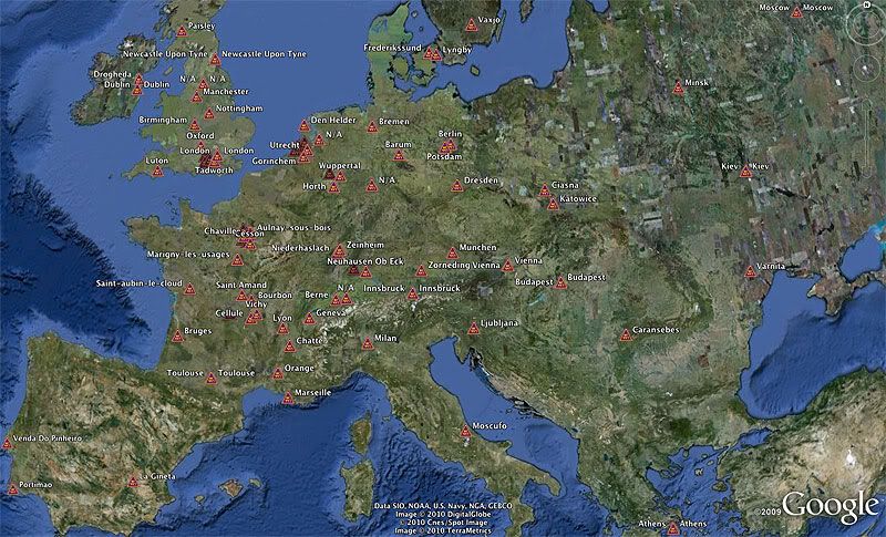
GB
GB
Last edited by GreatBear; 26th May 2010 at 01:40. Reason: Update image
Join Date: Jun 2009
Location: NNW of Antipodes
Age: 81
Posts: 1,330
Received 0 Likes
on
0 Posts
Hyperveloce made reference in a previous post to a couple of comments reported coming from the BEA and published in the French media. They were:-
This leads in nicely to Machinbird's observation that maybe they have been searching too far out, and the area closer in to the LKP needs investigation.
The above implies that the aircraft lost momentum quickly and was effectively stalled at or near FL350. Should that be the case, was icing of the pitots the problem?? It is possible the a/c encountered extreme turbulence suddenly, an updraft caught the starboard wing causing a left bank in excess of 45�, the A/P disconnected and the crew were left with lack of situational awareness and all hell breaking out around them. Was the nose pitched up and AOA moved beyond the CL limits and a deep stall resulted? We know the crew went looking for the "bird" - to no avail. The rotation of the a/c could account for the ADIRU disagreements over IAS, but one would have expected blanking of the engine intakes and flameouts. If that was the case, where were the ACARS WNG/FLT messages? The trim tank was probably full, which wouldn't have helped. Not unexpectedly, the final ACARS message is the Cabin Vertical Speed warning generated 5 secs after passing through 7,350 feet at a vertical speed greater than 1,800 ft/min. We don't positively know in what direction the cabin speed was moving, but it wouldn't be amiss at this time to conclude the cabin pressure was "high" and the a/c was descending.
Machinbird has made a point that needs looking at closely.
Finally, and I have asked before, does anyone know the format that Air France AOC positions are transmitted on ACARS. By that I mean, are there parameters other than the position sent? Probably a question to ask in the Tech Log. The BEA have made no comment on the LKP.
mm43
"AF447 has never been south, we lost one week" (Le Figaro)
"We assume we had a choice, the choice was to use the few days that we had to follow our program rather than remain in an area where we believe the probability of finding the wreckage relatively low "(M. Troadec in" The Point ")
"We assume we had a choice, the choice was to use the few days that we had to follow our program rather than remain in an area where we believe the probability of finding the wreckage relatively low "(M. Troadec in" The Point ")
The above implies that the aircraft lost momentum quickly and was effectively stalled at or near FL350. Should that be the case, was icing of the pitots the problem?? It is possible the a/c encountered extreme turbulence suddenly, an updraft caught the starboard wing causing a left bank in excess of 45�, the A/P disconnected and the crew were left with lack of situational awareness and all hell breaking out around them. Was the nose pitched up and AOA moved beyond the CL limits and a deep stall resulted? We know the crew went looking for the "bird" - to no avail. The rotation of the a/c could account for the ADIRU disagreements over IAS, but one would have expected blanking of the engine intakes and flameouts. If that was the case, where were the ACARS WNG/FLT messages? The trim tank was probably full, which wouldn't have helped. Not unexpectedly, the final ACARS message is the Cabin Vertical Speed warning generated 5 secs after passing through 7,350 feet at a vertical speed greater than 1,800 ft/min. We don't positively know in what direction the cabin speed was moving, but it wouldn't be amiss at this time to conclude the cabin pressure was "high" and the a/c was descending.
Machinbird has made a point that needs looking at closely.
Finally, and I have asked before, does anyone know the format that Air France AOC positions are transmitted on ACARS. By that I mean, are there parameters other than the position sent? Probably a question to ask in the Tech Log. The BEA have made no comment on the LKP.
mm43
Au Sud?
So Seabed Worker has been stood-down, and is en-route north-eastwards to the Cape Verde islands. Dommage! How disappointing for everyone concerned. The BEA is quoted as saying that AF447 was never (to be found) "to the south". I wonder. Ignoring human influence, one would indeed expect the flight to continue roughly in the original direction. But the aeroplane was already about 3nm left of track at its last-known position, and that is unlikely to have been due to a position-error in the FMC.
Assuming the deviation at that instant was the result of crew intervention, there are many possible scenarios, perhaps the least likely being a deliberate track offset of 3nm to reduce the risk of colliding with opposite-direction traffic as they approached the Dakar UIR boundary. Most crews would choose to fly right of track. It is more likely that they had either been avoiding wx for about five minutes (might even have been regaining track); and/or they were just starting to make a turn to avoid a cell recently identified on wx radar, or perhaps to negotiate a passage they had identified between clusters of cells. Finally, they might have been caught unprepared, suddenly encountering precipitation/St-Elmo's-fire/lightning-strike/moderate-to-severe-turbulence.
Perhaps it is not inappropriate, at this pause in the search, to remind ourselves of some of what this crew was up against in the next minute or so. What we do know is that, whatever they were doing, they would have been aware of that fairly rare event in the cruise, an AP disconnect − even if they did it themselves (unlikely). It's a familiar but noisy one, with a suitably-loud audio-warning, aptly called the cavalry charge; quickly cancelled by pressing the AP disconnect button on either sidestick.
Zeroing our stopwatch at AP disconnect, here are the known problems during the next 71 seconds:
T+06 − ECAM warning of windshear-detection fault. Master Caution (i.e., amber W/L illuminates) plus single chime. ECAM drill (when time permits), but not in itself a worry.
T+13 − ECAM warning that flight-controls (FBW) have degraded to Alternate Law, with most flight-envelope protections lost (attitude displays annotated with amber crosses). Master Caution + single chime. ECAM drill (urgent). Sinister event, but normal control straightforward.
[By this time, it is likely that the crew would be aware of ASI anomalies, probably indicating serious loss of airspeed. Descent may be under way.]
T+19 − Speed Limit flag appears on captain's ASI, confirming loss of underspeed and overspeed protections, and removing certain (valuable) reference-speed annotations.
T+31 − Ditto on F/O's ASI.
T+37 − ECAM warning of A/THR failure. Master Caution + single chime. ECAM drill. If descending steeply at this stage, throttles can be closed to ensure idle thrust.
T+44 − ECAM warning of TCAS fault. Master Caution + single chime. ECAM drill (when time permits). Irrelevant.
T+50 − Flag on captain's FD. Flight Director has failed. Realistically, he cannot be using it.
T+65 − Ditto on F/O's FD.
T+71 − ECAM warning of rudder-travel-limiter fault. Master Caution + single chime + Systems Display switches to the F/CTL page. ECAM drill... Use rudder with care. Who would be using rudder in this situation?
Would the handling pilot have continued straight ahead into this developing hell, or tried to turn the aeroplane away from it? Could he have turned as much as, say, 180 degrees?
Chris
PS: mm43, why would the aeroplane be stalled early-on, when the ASIs were UNDER-reading?
Join Date: Jul 2009
Location: Not far from a big Lake
Age: 81
Posts: 1,454
Likes: 0
Received 0 Likes
on
0 Posts
PS: mm43, why would the aeroplane be stalled early-on, when the ASIs were UNDER-reading?
This could be a crucial point.
Join Date: Aug 2009
Location: Germany
Age: 67
Posts: 1,777
Likes: 0
Received 0 Likes
on
0 Posts
Hi,
That's a sad end of the third researches attempt.
Honestly I'm not surprised they don't find the black boxes.
But I'm surprised they don't find any substential elements of the plane .. who must not be the size of a shoes box.
Or the BEA theory of sea impact like described is false and instead .. the plane was partially or completely desintegrated in air .. or they had search at the wrong places.
With no more clues of what we have so far .. this must be the last one (wrong places) the most probable.
So .. another search campaign must be set.
Join Date: Jun 2009
Location: Chesapeake Bay
Age: 79
Posts: 57
Likes: 0
Received 0 Likes
on
0 Posts
Circles
Stepping off the distance traveled between ACARS reports every ten minutes from the coast of Brazil would indicate straight and level flight at a nicely constant speed right up to the very last report. Small variations in speed are likely an artifact of the minute-wide time stamps.
It would seem that the A/C was just about exactly where it should have been when it last reported at 0210 (although we don't know its altitude, and it was at the time 3 miles left of track). If it had initiated a steep bank leftward, that would have occurred within the minute prior to 0210. Earlier, the reported distance traveled between reports at 0200 and 0210 would have been measurably less.
Until 0209 it would seem there was no deviation from track nor WX avoidance. If they were precisely on track at 0209, at a GS of 7.8nm/min (0.13nm/sec) it would have taken maybe 30 to 45 seconds to bank steeply away from the track to a distance of 3nm. So banking left remains a possibility prior to AP Disconnect.
The situation went pear-shaped suddenly within seconds either way of the 0210 ACARS report. Put the location of that last report at the center of a circle (2.98� N x 39.59� W) and estimate how far the A/C might have been able to fly (glide ratio maybe 20:1 clean but we know it wasn't clean, with ACARS reporting a high sink rate implied by cabin altitude warnings) in about 4.5 minutes without overspeed (A/C reported intact at impact) while the cockpit attempted to regain control from underspeed/overspeed stall, catastrophic wind shear, or whatever caused the upset. An exercise for one of you A330 drivers. Draw the circumference. Shouldn't be far. Should find the hull inside.
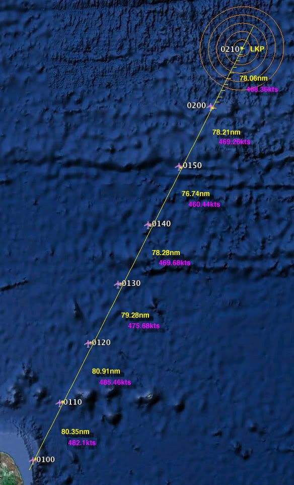
Now GS could have been cranking up during the 10 minutes after 0200 as the pitots began reading lower and lower and thrust was automatically increased to compensate, and the A/C could have initiated a turn back from further up the track and been returning in reverse when the 0210 report was sent. In any event, we know where the A/C was at 0210 and we infer from the missing expected ACARS message that the A/C was in the water less than five minutes later.
Draw the circle.
GB
It would seem that the A/C was just about exactly where it should have been when it last reported at 0210 (although we don't know its altitude, and it was at the time 3 miles left of track). If it had initiated a steep bank leftward, that would have occurred within the minute prior to 0210. Earlier, the reported distance traveled between reports at 0200 and 0210 would have been measurably less.
Until 0209 it would seem there was no deviation from track nor WX avoidance. If they were precisely on track at 0209, at a GS of 7.8nm/min (0.13nm/sec) it would have taken maybe 30 to 45 seconds to bank steeply away from the track to a distance of 3nm. So banking left remains a possibility prior to AP Disconnect.
The situation went pear-shaped suddenly within seconds either way of the 0210 ACARS report. Put the location of that last report at the center of a circle (2.98� N x 39.59� W) and estimate how far the A/C might have been able to fly (glide ratio maybe 20:1 clean but we know it wasn't clean, with ACARS reporting a high sink rate implied by cabin altitude warnings) in about 4.5 minutes without overspeed (A/C reported intact at impact) while the cockpit attempted to regain control from underspeed/overspeed stall, catastrophic wind shear, or whatever caused the upset. An exercise for one of you A330 drivers. Draw the circumference. Shouldn't be far. Should find the hull inside.
Now GS could have been cranking up during the 10 minutes after 0200 as the pitots began reading lower and lower and thrust was automatically increased to compensate, and the A/C could have initiated a turn back from further up the track and been returning in reverse when the 0210 report was sent. In any event, we know where the A/C was at 0210 and we infer from the missing expected ACARS message that the A/C was in the water less than five minutes later.
Draw the circle.
GB
Last edited by GreatBear; 26th May 2010 at 05:41. Reason: Typo: 2010 instead of 0210; fixed.