


Airbus Within 6ft of the Ground nearly 1 mile Short of Runway

Join Date: Oct 2015
Location: Tranquility Base
Posts: 77
Likes: 0
Received 0 Likes
on
0 Posts
I still think the machine should do this automatically by comparing QNH on the perf approach page with the QNH set on the FCU once on QNH.

Join Date: Mar 2012
Location: Having a margarita on the beach
Posts: 2,422
Likes: 0
Received 0 Likes
on
0 Posts
This is a typical case study of QNH blunder error where an SOP such as pre-setting the METAR/ATIS QNH prior to TOD could have prevented the incident. Many operators use this procedure as a safety net and it does work well indeed to trap errors both from the crew side and ATC. I believe that after this event more and more operators will include it in their procedures.

Only half a speed-brake
The extended squitter seems to have a data filed for selected Baro ref, however the last value is retained for transmission instead of STD when the crew changes to that.
Which brings us to another unexpected conclusion. Mode S must have been transmitting Q1011 after this almost doomed crew accepted the wrong instruction.
Hmm, some opportunities there!
Join Date: Jan 2008
Location: Europe
Posts: 135
Likes: 0
Received 0 Likes
on
0 Posts
The extended squitter seems to have a data filed for selected Baro ref, however the last value is retained for transmission instead of STD when the crew changes to that.
Which brings us to another unexpected conclusion. Mode S must have been transmitting Q1011 after this almost doomed crew accepted the wrong instruction.
Which brings us to another unexpected conclusion. Mode S must have been transmitting Q1011 after this almost doomed crew accepted the wrong instruction.
I don't know whether the CDG controllers typically see it on their screens (either fulltime or as an option) or not.
Only half a speed-brake
Point being made, would it not be a useful feature of the ATC kit to automatically track and alert for any selected Baro REF discrepancies of the arriving aircraft?
Surely that was the idea behind having it in the dataset.
Surely that was the idea behind having it in the dataset.
Join Date: Feb 2008
Location: Earth until ..........
Posts: 39
Likes: 0
Received 0 Likes
on
0 Posts
Every cheese has holes
This is a typical case study of QNH blunder error where an SOP such as pre-setting the METAR/ATIS QNH prior to TOD could have prevented the incident. Many operators use this procedure as a safety net and it does work well indeed to trap errors both from the crew side and ATC. I believe that after this event more and more operators will include it in their procedures.
This crew ( PF ) set the QNH but forgot to switch back to STD and was cleared descent to a Flight Level. A Level bust occurred using QNH instead of STD.
If this had happened in the LTMA the approach controller would have had a flashing alert on the radar that the wrong QNH was set as soon as they were descending through the TL, surprised there�s not similar for CDG. Link
Implement without delay, a procedure to mitigate the risks of an incorrect QNH setting affecting both altimeters during approaches using the baro-VNAV function, possibly by crosschecking the QNH with another source of information, in particular with the ATIS information when available or by asking the controller for confirmation of the QNH.
The BEA makes no reference to the solution adopted by NATS, though it's anybody's guess whether it is simply avoiding being prescriptive as to the solution that it is recommending CDG should adopt, or whether they are unaware of how other ANSPs tackle the issue.
Last edited by DaveReidUK; 18th Jul 2022 at 06:29. Reason: ANSPs, not ANPs
I have looked but I can't find the FCOM reference for that procedure.
Airmanship isn’t in the FCOM.
Airmanship isn’t in the FCOM.
This procedure was used by my outfit when we operated Airbus and worked well. However one pitfall ( and this happened on a flight ) is the setting of QNH and forgetting to switch back to STD.
This crew ( PF ) set the QNH but forgot to switch back to STD and was cleared descent to a Flight Level. A Level bust occurred using QNH instead of STD.
This crew ( PF ) set the QNH but forgot to switch back to STD and was cleared descent to a Flight Level. A Level bust occurred using QNH instead of STD.
Join Date: Mar 2006
Location: USA
Posts: 2,515
Likes: 0
Received 0 Likes
on
0 Posts
This procedure was used by my outfit when we operated Airbus and worked well. However one pitfall ( and this happened on a flight ) is the setting of QNH and forgetting to switch back to STD.
This crew ( PF ) set the QNH but forgot to switch back to STD and was cleared descent to a Flight Level. A Level bust occurred using QNH instead of STD.
This crew ( PF ) set the QNH but forgot to switch back to STD and was cleared descent to a Flight Level. A Level bust occurred using QNH instead of STD.
Some people set the destination QNH when climbing through TA on the sid.
Both methods are only technique though.
Pegase Driver
Join Date: May 1997
Location: Europe
Age: 74
Posts: 3,684
Likes: 0
Received 0 Likes
on
0 Posts
DaveReidUK :
It is the second option. afaik.
The BEA makes no reference to the solution adopted by NATS, though it's anybody's guess whether it is simply avoiding being prescriptive as to the solution that it is recommending CDG should adopt, or whether they are unaware of how other ANSPs tackle the issue.
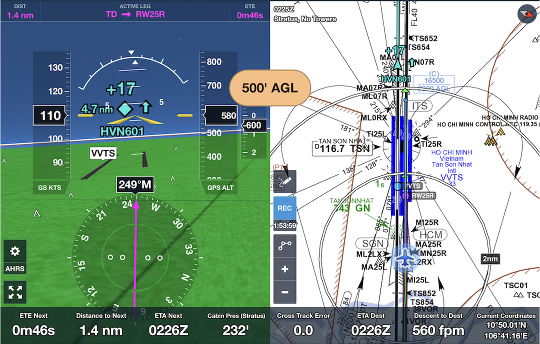
When we sit in our aircraft, we have in front of us 120 year old pressure displayed instruments.... we also have a display that gives our geometric altitude, and a synthetic view of the world in front, including terrain alerting and obstacles. Operating into an airfield that is 6,000' up and -30C makes it desirable to actually know what your physical separation from bad days are. In this event, the crew would have received an alert that they were landing in a paddock, outside of the passengers preferred arrival location, and they would see a FPV that was aiming 1nm short of the runway threshold, the display would show the threshold moving away from the FPV at an ever increasing rate until it gets rowdy.
Point is, our safety is predicated on a weak system of communications, mon dieu, and placing the fix at the same side that is already showing problems with task saturation and process maintenance seems to be less than optimal. The people with the vested interest in arrival at the correct place in space if not time are the drivers.
At cruise, the difference is a curiosity, geometric altitude is normally around 1500' higher than the FL, but it remains quite stable for periods dependent on the airmass, on an approach, the PA and geometric altitude converge, and at around 3000' PA there is normally not more than 20' error at ISA, but as per cold temp correction factors, there is considerable difference to the uncorrected PA altitude... If the corrections are correctly applied, or the G/S is a valid (geometric) track, then the FPA sits on the end of the runway. There is no cognitive load to looking at a happy map of the world in front, and this display is specifically not corrected to PA for the very reason that we want to see real world, not someones communicated information on the local airmass characteristics.
It happens to display on an iPad, it can display on an iPhone... Could it be added as a display to any aircraft? of course, but there is no current TSO standard that would be relevant to such a display, as we are firmly committed to the 18th century in technology.
Thread Starter
Join Date: Dec 2020
Location: Manchester
Posts: 52
Likes: 0
Received 0 Likes
on
0 Posts
I suspect 99% of the replies on here have missed the overriding law in aviation.
Its referred to as 'tombstone safety'. Nothing changes until there are deaths and it costs more in insurance payouts than to fix the problem.
How much would it cost, apart from the dint in nationalistic pride, for it to be compulsory for English to be used at one of the busiest airports in Europe. Let's remember standard RT phraseology does not mean having to be fluent. Indeed if you said 'QNH' to a typical Englishman you might as well be talking Mandarin. How hard can it be?
Join Date: Dec 2019
Location: OnScreen
Posts: 415
Likes: 0
Received 0 Likes
on
0 Posts
I suspect 99% of the replies on here have missed the overriding law in aviation.
Its referred to as 'tombstone safety'. Nothing changes until there are deaths and it costs more in insurance payouts than to fix the problem.
How much would it cost, apart from the dint in nationalistic pride, for it to be compulsory for English to be used at one of the busiest airports in Europe. Let's remember standard RT phraseology does not mean having to be fluent. Indeed if you said 'QNH' to a typical Englishman you might as well be talking Mandarin. How hard can it be?
Its referred to as 'tombstone safety'. Nothing changes until there are deaths and it costs more in insurance payouts than to fix the problem.
How much would it cost, apart from the dint in nationalistic pride, for it to be compulsory for English to be used at one of the busiest airports in Europe. Let's remember standard RT phraseology does not mean having to be fluent. Indeed if you said 'QNH' to a typical Englishman you might as well be talking Mandarin. How hard can it be?
I did not see an explanation/assumption in the report, why the ATC got it wrong in English.
Join Date: Dec 2019
Location: OnScreen
Posts: 415
Likes: 0
Received 0 Likes
on
0 Posts
When we sit in our aircraft, we have in front of us 120 year old pressure displayed instruments.... we also have a display that gives our geometric altitude, and a synthetic view of the world in front, including terrain alerting and obstacles. Operating into an airfield that is 6,000' up and -30C makes it desirable to actually know what your physical separation from bad days are. In this event, the crew would have received an alert that they were landing in a paddock, outside of the passengers preferred arrival location, and they would see a FPV that was aiming 1nm short of the runway threshold, the display would show the threshold moving away from the FPV at an ever increasing rate until it gets rowdy.
Point is, our safety is predicated on a weak system of communications, mon dieu, and placing the fix at the same side that is already showing problems with task saturation and process maintenance seems to be less than optimal. The people with the vested interest in arrival at the correct place in space if not time are the drivers.
At cruise, the difference is a curiosity, geometric altitude is normally around 1500' higher than the FL, but it remains quite stable for periods dependent on the airmass, on an approach, the PA and geometric altitude converge, and at around 3000' PA there is normally not more than 20' error at ISA, but as per cold temp correction factors, there is considerable difference to the uncorrected PA altitude... If the corrections are correctly applied, or the G/S is a valid (geometric) track, then the FPA sits on the end of the runway. There is no cognitive load to looking at a happy map of the world in front, and this display is specifically not corrected to PA for the very reason that we want to see real world, not someones communicated information on the local airmass characteristics.
It happens to display on an iPad, it can display on an iPhone... Could it be added as a display to any aircraft? of course, but there is no current TSO standard that would be relevant to such a display, as we are firmly committed to the 18th century in technology.
Point is, our safety is predicated on a weak system of communications, mon dieu, and placing the fix at the same side that is already showing problems with task saturation and process maintenance seems to be less than optimal. The people with the vested interest in arrival at the correct place in space if not time are the drivers.
At cruise, the difference is a curiosity, geometric altitude is normally around 1500' higher than the FL, but it remains quite stable for periods dependent on the airmass, on an approach, the PA and geometric altitude converge, and at around 3000' PA there is normally not more than 20' error at ISA, but as per cold temp correction factors, there is considerable difference to the uncorrected PA altitude... If the corrections are correctly applied, or the G/S is a valid (geometric) track, then the FPA sits on the end of the runway. There is no cognitive load to looking at a happy map of the world in front, and this display is specifically not corrected to PA for the very reason that we want to see real world, not someones communicated information on the local airmass characteristics.
It happens to display on an iPad, it can display on an iPhone... Could it be added as a display to any aircraft? of course, but there is no current TSO standard that would be relevant to such a display, as we are firmly committed to the 18th century in technology.
What we are missing is the "independent and automated verification" of what flight path the flight crew creates/follows with the tools they have available (or should have available in the ideal situation). The verifier is the one that saves the lives, when the flight crew screws up, for whatever reason.