


737 reported down in Canada


Joined: Dec 2007
Posts: 879
Likes: 177
From: Itinerant
Ross...
From the Boeing tech website:
"Whatever surface was to be used, certain guidelines had to be observed. The surface had to be smooth with no bumps higher than 3 inches in 100ft; good drainage with no standing water or ruts; and the surface material had to be at least 6 inches thick with no areas of deep loose gravel. Boeing offered a survey service to assess the suitability of potential strips. If a surface was not particularly hard it could still be used by reducing tyre pressure down to a minimum 40psi in accordance with a chart.
The Boeing "unpaved Strip Kit" components include:
Nose-gear gravel deflector to keep gravel off the underbelly.
Smaller deflectors on the oversized main gear to prevent damage to the flaps.
Protective metal shields over hydraulic tubing and brake cables on the main gear strut.
Protective metal shields over speed brake cables.
Glass fibre reinforced underside of the inboard flaps.
Metal edge band on elephant ear faring.
Abrasion resistant Teflon based paint on wing and fuselage undersurfaces. Strengthened under-fuselage aerials.
Retractable anti-collision light.
Vortex dissipators fitted to the engine nacelles.
Screens in the wheel well to protect components against damage."
More info can be found at: http://www.b737.org.uk/unpavedstripkit.htmI
I was aboard a PWA B737 conducting tests of the effectiveness of the kit components at various unimproved strips in the Pacific Northwest waaaay back in 1971.

Joined: Nov 2007
Posts: 1,127
Likes: 0
From: Yellow Brick Road
Thanks Grizz, as I was puzzled by different bits of the kit when I saw its photos. Btw, this link works better:
Unpaved Strip Kit
Unpaved Strip Kit
Joined: Jun 2001
Posts: 2,627
Likes: 2
From: UTC +8
very high fuel and maintenance costs, comparatively long stagelengths and low utilisation make the economics marginal, at best.


Joined: Sep 2003
Aviation Qualifications: ATPL
Posts: 955
Likes: 68
From: away from home
Punkalouver wrote:
As I recall with older GPWSs with gear down and flaps in any landing position, no further warnings. And the old radio altimeters sure don't talk to you. So both ZBBYLW and Lost in Saigon have it right.
Either you don't know what you are talking about punkalouver or you have forgotten... It's even described on Wiki.
I should think that you don't know what you are talking about. You delete your post and I'll delete this one.
Either you don't know what you are talking about punkalouver or you have forgotten... It's even described on Wiki.


Joined: Dec 1999
Posts: 330
Likes: 0
From: Ottawa, Ontario, Canada
As a geologist (but not a pilot), I've flown in and out of Resolute many times over the course of 40 years or so, so am familiar with the area.
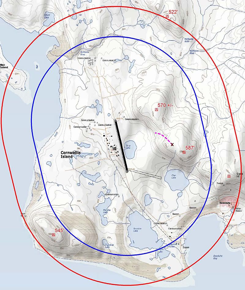
I'm pretty sure that the wreckage trail shown in purple on Aterpster's map is incorrect. Judging by the photo posted by Downnorth (post #8), the trail ends to the right (south) of the stream cut, which is very apparent in the topographic map. I would imagine the wreckage trail is actually roughly parallel to the runway
I would be very surprised if it turns out that the pilots had decided to attempt a landing on Rwy17. In my experience, back course approaches at Resolute are almost never done.
Joined: Feb 2006
Aviation Qualifications: ATPL
Posts: 490
Likes: 15
From: USA
I'm pretty sure that the wreckage trail shown in purple on Aterpster's map is incorrect. Judging by the photo posted by Downnorth (post #8), the trail ends to the right (south) of the stream cut, which is very apparent in the topographic map. I would imagine the wreckage trail is actually roughly parallel to the runway
So, your estimate is that the initial impact was Southeast of the 587' elevation on aterpster's map?
Per Ardua ad Astraeus
Joined: Mar 2000
Posts: 18,575
Likes: 4
From: UK
Has it been established which way the wreckage trail runs? Does 'X' mark initial or final point? There could almost be a fuel spill line running to the right of the main fuselage part. I'm not sure the exact location of where the poor souls died is too critical - altitude and direction of flight will be more so?
Joined: Aug 2011
Posts: 5
Likes: 0
From: BC
direction of flight
I'm thinking they were still northbound, based on the wreckage trail. Light stuff stays put heavier stuff moves in the direction of the flight and it sort of looks like engine components are to the left in the picture. Perhaps they were visual and circling, Captain flying from the left seat so he widens to the right to keep the runway in sight. In low vis he may not have had good visual detail of the terrain and flew right into in. The relatively long wreckage trail, and the fact there were survivors suggest controlled flight into terrain at relatively shallow impact angle.
Joined: Nov 2004
Posts: 1,322
Likes: 155
From: Here, there, and everywhere
As for circling, I suspect a red herring. Why would you circle when there is more than one straight-in approach to similar minimums for runway 17. Why not just do the ILS and land with a tailwind within limits.
Last edited by punkalouver; 26th August 2011 at 15:00.
Guest
Joined: Apr 2009
Posts: 3,336
Likes: 0
From: On the Beach
Rockhound:
The wreckage trail is an approximation. But, the point of impact is from AvHerald and is in conformance with the photo you refer to. The point is, it appears he crashed within the Runway 35 ILS T circle to land area. My circle to land areas are indisputable.
That means you don't understand the circle to land option on many instrument approach procedures, including this one. I don't mean to be negative, but the nuances of an instrument approach procedure are not learned overnight by pilots.
As to the back course approach another pilot flew that just before the crash and missed the approach because of a low cloud deck. He tired the back course approach again with better weather a bit later, and saw the burning wrecking as he broke out of the clouds on final approach to Runway 17.
As a geologist (but not a pilot), I've flown in and out of Resolute many times over the course of 40 years or so, so am familiar with the area.
I'm pretty sure that the wreckage trail shown in purple on Aterpster's map is incorrect. Judging by the photo posted by Downnorth (post #8), the trail ends to the right (south) of the stream cut, which is very apparent in the topographic map. I would imagine the wreckage trail is actually roughly parallel to the runway.
I'm pretty sure that the wreckage trail shown in purple on Aterpster's map is incorrect. Judging by the photo posted by Downnorth (post #8), the trail ends to the right (south) of the stream cut, which is very apparent in the topographic map. I would imagine the wreckage trail is actually roughly parallel to the runway.
I would be very surprised if it turns out that the pilots had decided to attempt a landing on Rwy17. In my experience, back course approaches at Resolute are almost never done.
As to the back course approach another pilot flew that just before the crash and missed the approach because of a low cloud deck. He tired the back course approach again with better weather a bit later, and saw the burning wrecking as he broke out of the clouds on final approach to Runway 17.
Joined: Dec 1999
Posts: 330
Likes: 0
From: Ottawa, Ontario, Canada
In the photo in post #8, the wreckage pile on the right includes the tail so the motion of the aircraft must have been from right (south) to left (north). The trail does not cross the stream cut. The "x" in Aterpster's map may well mark the impact point accurately.
I still find the suggestion that he was circling to land on Rwy 17 difficult to accept. A tailwind of 10-15 knots straight down the runway should present no difficulties for a 737.
I still find the suggestion that he was circling to land on Rwy 17 difficult to accept. A tailwind of 10-15 knots straight down the runway should present no difficulties for a 737.
Joined: Mar 2006
Posts: 1,974
Likes: 0
From: Choroni, sometimes
In the photo in post #8, the wreckage pile on the right includes the tail so the motion of the aircraft must have been from right (south) to left (north).
Joined: Apr 2000
Posts: 450
Likes: 0
From: BC
CYRB Approaches....
I've shot approaches to both sides (17/35T), numerous times, both in PWA/Canadi>n Airlines B7372s and Hercs. What to say other than its a very sad day up there. We can sit here all we want and try and 'figure out' what was going on there but in the end,some of the answers will be found on the FDR, and CVRs if the data is good, and by the investigators who are charged at trying to figure out what really went wrong.
There are so many variables about flying into Res'...if there was fog, then it can be a real can of worms. The fog takes on a life of its own up there, depending on the prevailing wind. Sometimes, what one expects to see and what actually 'is' are two different things. Let me say that flying in the Canadian high arctic was some of THE most demanding flying that a pilot could ever experience, on a good day...when was the last time that any of you ever used 'destination grid' and 'grid offsets' or ever aligned your compasses with a sextant, prior to the approach? Why you ask? Magnetic compasses don't work up there and the gyros have to be manually aligned because they aren't slaved.
'Thoughts are with the families who lost a loved one in this'. Its never easy.
Guest
Joined: Apr 2009
Posts: 3,336
Likes: 0
From: On the Beach
Rockhound:
Check this site. It has a second photo that better shows the wreckage distribution. The text also indicates the flight reported on final for Runway 35:
Crash: First Air B732 near Resolute Bay on Aug 20th 2011, impacted terrain
Check this site. It has a second photo that better shows the wreckage distribution. The text also indicates the flight reported on final for Runway 35:
Crash: First Air B732 near Resolute Bay on Aug 20th 2011, impacted terrain

Joined: Jul 2004
Aviation Qualifications: ATPL
Posts: 637
Likes: 17
From: Found in Toronto
In any case your suggestions of "economics of operations" are incorrect.
This was a privately chartered cargo aircraft that also is configured to carry passengers. I am quite sure it would have been filed to capacity with cargo and would have been operated as economically as possible. Cargo charters are the only lifeline to remote communities such as this. Everyone in the far north knows fully well what it costs to maintain a community in such a remote location.
But, even if the person who chartered the aircraft chose to fly it half empty, why would that be worth commenting on?
Last edited by Lost in Saigon; 23rd August 2011 at 01:45.
Joined: Dec 2004
Posts: 27
Likes: 0
From: Great White North
CYRB First Air 737 crash
After reading the Aviation Herald article and comments;
Crash: First Air B732 near Resolute Bay on Aug 20th 2011, impacted terrain
I am concerned that, given the perceived impact location and track of the debris field, the a/c may have been chasing a false localizer course. The location�s offset from the localizer�s centreline (localizer being a couple of thousand feet past the stop-end in this case) suggests a possible false course. This ILS is thirty years old plus (and a second hand installation . . . used elsewhere before Resolute). ICAO deemed this ILS model unacceptable . . . no longer to be installed as of about the end of the 1990�s. This model has had a know history of false courses.
The installation is somewhat �unique� and apparently required some optimisations given the immediate airport terrain. On a false LOC course . . . the GP course (rate of descent) may not look that unreasonable. The locator NDB (2.1 N.M. before threshold on extended centreline) was decommissioned last summer . . . so you no longer have that reference to tell you it�s on your port/starboard/or behind you when the DME is counting you down to threshold.
The post incident flight check will be performed by the same people who installed and maintain this ILS. Transport Canada and the TSB no longer have flight inspection capabilities . . . unless they contract it from somebody other than Canada�s privately owned air navigation system operator.
Sure hope the CVR and FDR are good and have lots of data points.
And please remember, ILS is a System with many other information inputs . . . not just LOC & GP crosshairs . . . . . . .