


SAR S-92 Missing Ireland

Cnpc...it can be very different a hundred meters away.
I've flown the mountains and cliffs in Ireland for twenty plus years...Initially in gliders and now paragliders.
The Dublin and Ulster gliding clubs run an expedition to Kerry in autumn.
I considered bailing out when ridge soaring east of mount Brandon when I was engulfed in orographic cloud...a sort of flash over effect. Unfortunately I had installed an ex RAF horizon with an inverta which wasn't the fastest gyroscope to erect. I used my gps to escape.
Another wave flight I decided to jump over the northern end of mount Brandon with an orographic cloud base of 1,000ft. The mountain is 3,000 ft plus.
I tracked around 12km along the face and about 1 km out to sea...the lift closer in was so strong that I was close to VNE even at 1 km.
After one pass the mountain and sea completely disappeared as an embedded storm passed through...
Because Ireland is stuck out into the Atlantic the weather changes extremely quickly and sometimes visciously.
As to the flow around and behind the light house it could be anything...I be seen a viscous cloud similar to a microburst impacting a road in the lee of one of the Canaries...The flow around cone shaped mountains isn't nice although I have managed to soar a couple and somewhere there is a video of flows around cones.
Assuming they were proceeding in low vis under a stratus layer with a base below the light, if the layer might have been disrupted in the immediate area of the rock with that southwest wind being forced up the cliff. And, if that might have given a glimpse of the light, or might have been what allowed the crewman to see the "island" at the last moment.
I think the aircraft would have been on the windward side in this scenario.
Anybody know if there is a recording of the IR camera gear?
Are we now dancing around the maypole for the second or third time with folks posting questions that have already been asked and answered?
Understanding of course that many questions can not be answered because there are facts not in evidence.
Therefore there is a lot of, as usual in tragic cases like this, a lot of rumours, innuendos and hearsay.
Understanding of course that many questions can not be answered because there are facts not in evidence.
Therefore there is a lot of, as usual in tragic cases like this, a lot of rumours, innuendos and hearsay.
Albatross - yes, I think we have got to the 'FFS read the thread' stage and the 'are there any more pointless questions' level - the discussion about the visibility of the lighthouse is so irrelevant to the actual causes of this accident it beggars belief.
If I have read posts in this Thread correctly....118 started their first approach to Blacksod at a point much closer to Blacksod and well away from Blackrock itself.
If they in fact used SAR Modes to make an automated approach to that Waypoint then found their way to Blacksod that was just a Kilometer or two (just guessing here on the distance) then I see them doing what I would think far safer and much more in line with "modern" thinking rather than a let down in open water to find the surface then run Ten Miles at 200 feet to Blacksod as 116 did.
Visibility is an issue, whether they could see the Blackrock Light definitely is an issue.
We know they did not grasp the danger they were in re Blackrock due to its elevation and their height above the surface.
Hopefully, analysis of the full CVR will offer up the explanation for so many of the questions being discussed.
Four very professional SAR Crew Members apparently flew a serviceable and very well equipped Aircraft into terrain at night in very bad weather. Most of us look to this crew and think how it could have been anyone of us that came up short that night.....and naturally realizing that provokes a lot of questions as it should.
Re sighting of light in fog.
St. Catherine's Lighthouse (Isle of Wight) was originally constructed as a forty metre high tower, but subsequently reduced to twenty seven metres in 1875 because of difficulty sighting the light in fog. Is currently the third most powerful light maintained by Trinity.
Mariners use the following tables
Meteorological Optical Range Table
Code No.XXXWeatherXXXXXXXXXXXXXXDistance
0XXXXXXXXDense fogXXXXXXXXXXXXXLess than 50
1XXXXXXXXThick fogXXXXXXXXXXXXXf50 - 200 yards
2XXXXXXXXModerateXXXXXXXXXXXXf200 - 500 yards
3XXXXXXXXLight fogXXXXXXXXXXXXX500 - 1000 yards
4XXXXXXXXThin fog XXXXXXXXXXXXXX.5 - 1.0 nm
5XXXXXXXXHaze XXXXXXXXXXXXXXXX1.0 - 2.0 nm
6XXXXXXXXLight HazeXXXXXXXXXXXX2.0 - 5.5 nm
7XXXXXXXXClearXXXXXXXXXXXXXXXX5.5 - 11.0 nm
8XXXXXXXXVery ClearXXXXXXXXXXXX11.0 - 27.0 nm
9XXXXXXXXExceptionally ClearXXOver 27.0
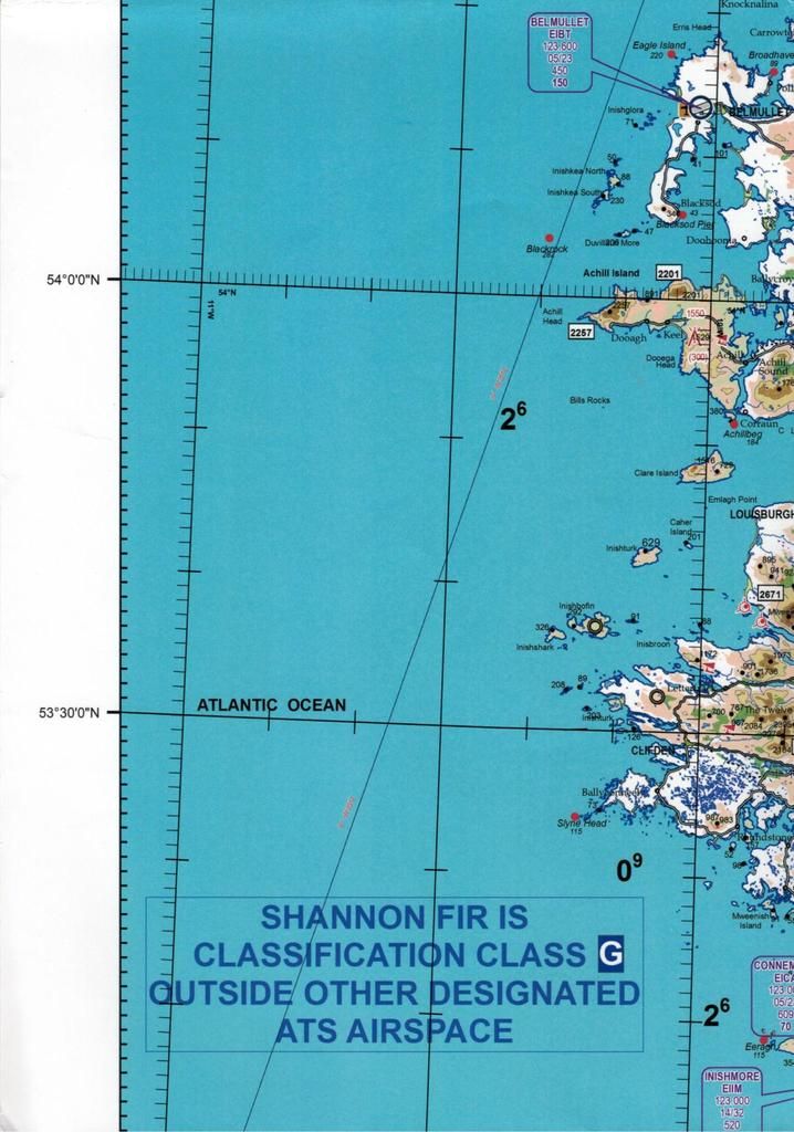
Personally I don't see how they could have seen the light if you plot on the following chart.
St. Catherine's Lighthouse (Isle of Wight) was originally constructed as a forty metre high tower, but subsequently reduced to twenty seven metres in 1875 because of difficulty sighting the light in fog. Is currently the third most powerful light maintained by Trinity.
Mariners use the following tables
Meteorological Optical Range Table
Code No.XXXWeatherXXXXXXXXXXXXXXDistance
0XXXXXXXXDense fogXXXXXXXXXXXXXLess than 50
1XXXXXXXXThick fogXXXXXXXXXXXXXf50 - 200 yards
2XXXXXXXXModerateXXXXXXXXXXXXf200 - 500 yards
3XXXXXXXXLight fogXXXXXXXXXXXXX500 - 1000 yards
4XXXXXXXXThin fog XXXXXXXXXXXXXX.5 - 1.0 nm
5XXXXXXXXHaze XXXXXXXXXXXXXXXX1.0 - 2.0 nm
6XXXXXXXXLight HazeXXXXXXXXXXXX2.0 - 5.5 nm
7XXXXXXXXClearXXXXXXXXXXXXXXXX5.5 - 11.0 nm
8XXXXXXXXVery ClearXXXXXXXXXXXX11.0 - 27.0 nm
9XXXXXXXXExceptionally ClearXXOver 27.0
Personally I don't see how they could have seen the light if you plot on the following chart.
Join Date: Jul 2002
Location: Downwind
Posts: 348
Likes: 0
Received 0 Likes
on
0 Posts
Four very professional SAR Crew Members apparently flew a serviceable and very well equipped Aircraft into terrain at night in very bad weather. Most of us look to this crew and think how it could have been anyone of us that came up short that night.....and naturally realizing that provokes a lot of questions as it should.
SAS, if you don't mind, that quote will appear in my training notes.
Visibility is an issue, whether they could see the Blackrock Light definitely is an issue.
The lighthouse may or may not have shone in their direction during the crucial period before the crash but they weren't expecting it to be there and therefore were not looking for it. Instead, they were doing as trained and monitoring the MFDs, albeit with the possibility of a radar contact obscured by WP data.
They may also have had their landing lamps on which would produce many reflections but all they were expecting outside is sea, sea and more sea since they were a long way from the coast and Blacksod.
The lighthouse beam is irrelevant in all aspects other than it might have been the last thing to save them - if they had been looking for it.
The fact is the rock became visible to the FLIR operator in time to avoid it but that didn't happen due to procedural focus by the flight crew.
Concentrate on why that happened rather than obsessing about the lighthouse visibility.
Join Date: Feb 2001
Location: Europe
Posts: 535
Likes: 0
Received 0 Likes
on
0 Posts
Agree Crab - lighthouse is almost incidental.
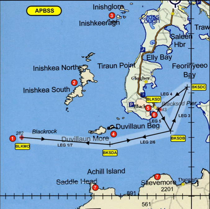
Back to the beginning of events, and basic procedure, would the Dublin SAR base have included a 250k or 500k VFR chart of Ireland pinned on the wall? Does SAR flight planning include looking at relevant hard copy charts? And would it have been expected that a crew would look at any likely approach - in this case APBSS - with reference to a VFR chart?
Back to the beginning of events, and basic procedure, would the Dublin SAR base have included a 250k or 500k VFR chart of Ireland pinned on the wall? Does SAR flight planning include looking at relevant hard copy charts? And would it have been expected that a crew would look at any likely approach - in this case APBSS - with reference to a VFR chart?
The other question that I have is when did the Approach transition from Being IMC to VMC.....or did it at all?
As there was no mention of the Blackrock Light being seen....I am of the opinion the crew was IMC until very shortly before impact with Terrain.
In my opinion....the descent to 200 feet headed away from land while over open water is where visual contact with the surface was planned. Then it was supposed to bea VMC transit to Blackrock picking up increasing visual cues along the way in the form of surface lights.
We have to consider what cues would have been visible to a Crew who DID NOT HAVE NIGHT VISION DEVICES beyond the FLIR which was in operation and being used (but in what Mode remains unknown to us).
It was damned dark that night....the Crew were still using. MK I Eyeballs to see.
Just what could they be expected to see?
What should they have seen if VMC?
The Blackrock Light is not incidental if one assumes the Crew thought themselves VMC....but were not.
Is there anyone here that would cruise at 200 feet AGL while IMC for Ten Miles knowing there was any obstruction along the flight path?
Don't confuse the IMC/VMC flight with being in cloud or clear of cloud.
They would have been in cloud until about 300' based on the met reports so by the time they were at 200' they should have been clear of cloud.
Did that make any difference to what they could see - even if they had been looking out (which I very much doubt for reasons previously mentioned)?
It was very dark, over the sea with a low cloudbase and no cultural lighting - that is IMC in anyone's book if you don't have NVG.
yes, if it was necessary and the radar operator was up to the job.
It wasn't necessary to get so low so early in order to get to Blacksod - why they chose to do that is a big question and the answer is probably in SOPs and culture inherited from previous types.
They would have been in cloud until about 300' based on the met reports so by the time they were at 200' they should have been clear of cloud.
Did that make any difference to what they could see - even if they had been looking out (which I very much doubt for reasons previously mentioned)?
It was very dark, over the sea with a low cloudbase and no cultural lighting - that is IMC in anyone's book if you don't have NVG.
Is there anyone here that would cruise at 200 feet AGL while IMC for Ten Miles knowing there was any obstruction along the flight path?
It wasn't necessary to get so low so early in order to get to Blacksod - why they chose to do that is a big question and the answer is probably in SOPs and culture inherited from previous types.
Agreed....but if it as you say about SOP's and inherited practices....why the difference in the way 118 successfully found Blacksod a couple of times that night as compared to how 116 tried but failed?
Join Date: Sep 2007
Location: Birmingham
Posts: 244
Likes: 0
Received 0 Likes
on
0 Posts
The crew were experienced and presumably had flown this approach on a number of occasions.
If Blackrock was a waypoint on the let down to Blacksod if they had been visual (which they clearly weren't) they would have been looking for it and/or seen the lighthouse beacon.
If they were IMC they would presumably have been aware that the hazard wasn't in the database from previous trips.
Even when the winchman saw it on the IR after an audible terrain warning there was no real urgency that suggested an imminent threat.
Hard to comprehend if you don't routinely fly for miles at 200' at night
Hard to understand and very sad.
Last edited by birmingham; 27th Apr 2017 at 12:49.
Without knowing the relative experience levels of the two crews that is a difficult question to answer.
Guest
Posts: n/a
Agree Crab - lighthouse is almost incidental.
Back to the beginning of events, and basic procedure, would the Dublin SAR base have included a 250k or 500k VFR chart of Ireland pinned on the wall? Does SAR flight planning include looking at relevant hard copy charts? And would it have been expected that a crew would look at any likely approach - in this case APBSS - with reference to a VFR chart?
Back to the beginning of events, and basic procedure, would the Dublin SAR base have included a 250k or 500k VFR chart of Ireland pinned on the wall? Does SAR flight planning include looking at relevant hard copy charts? And would it have been expected that a crew would look at any likely approach - in this case APBSS - with reference to a VFR chart?
And here's the APBSS chart for comparison. Interestingly again, the caption Blackrock isn't very closely associated with the obstacle.
Last edited by puntosaurus; 27th Apr 2017 at 14:04.
Join Date: Sep 2003
Location: uk
Posts: 119
Likes: 0
Received 0 Likes
on
0 Posts
It isn't hard to understand. They knew the islands were there. For whatever reason they thought their route was safe at 200'. Explains why they didn't abort when the rad alt went off, explains why they were in FMS guidance not heading hold, and explains the lack of urgency when the technical crew warned of Blackrock.
Being brought up navigating with a compass, map and stopwatch if your destination is a red blob with 43 written on the side then another waypoint with a red blob and 282 written beside it is 282 ft. high.
It isn't hard to understand. They knew the islands were there. For whatever reason they thought their route was safe at 200'. Explains why they didn't abort when the rad alt went off, explains why they were in FMS guidance not heading hold, and explains the lack of urgency when the technical crew warned of Blackrock.

Join Date: Dec 2013
Location: Norfolk
Age: 67
Posts: 1
Likes: 0
Received 0 Likes
on
0 Posts
On both of the examples shown, the final digit of the height shown for Black Rock is overshadowed by other markings and could easily have been read as 28 rather than 282. I believe this has already been commented on in an earlier posting as a possibility.
It is often the most mundane things that catch you out and easy to miss an overshadowed digit if you aren't specifically looking for it, especially with other displays and instruments demanding attention.
It is often the most mundane things that catch you out and easy to miss an overshadowed digit if you aren't specifically looking for it, especially with other displays and instruments demanding attention.
I'd be interested to see the procedure in it's entirety (including any notes). To my mind the route diagram is very 'back of a fag packet' for what they were trying to achieve in those conditions.