


The Home of Photos in Dunnunda! Mk I

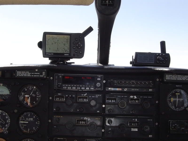
Jaba, I wouldn't mind that computer with all the eWAC's, but 1 GPS is enough for me,  .
.
morno
.morno

"but 1 GPS is enough for me"
Morno, true - until you have a total electrical failure in IMC ( I have had 2 in the last 10 years). The Garmin 296 will run for 12 - 14 hrs on its battery - will take me anywhere I want to go - and I would have no hesitation in flying an RNAV Appr with it, if I had to.
I just set the 296 to the departure airfield on departure so I have "distance from" until done with that - then I set it on the destination airfield. In conjunction with the Shadin digital fuel flow, lets me see how I am travelling against fuel reserves. This is handy as I often fly long legs, or "out and backs".
It was this combination that let me recently take on Tennant Ck to Broome direct (686 nm across the Tanami), with confidence that I had good IFR reserves on arrival Broome.
The Motion Computing LS800 on the yoke has JeppView electronic flightbag and FliteDeck, plus all of the Ozzie WACs, ERCs, TACs, VNCs, and VTCs in electronic format running in Fugawi Moving Map. It also has Next 3 high speed broadband anywhere it can get a decent signal - for weather updates, flightplanning, weather radar sites etc, email, movies, in-flight porn etc. Very handy bit of kit!
Dr
Last edited by ForkTailedDrKiller; 30th Nov 2007 at 23:57.
Join Date: Apr 2002
Location: Alice Springs
Posts: 1,744
Likes: 0
Received 0 Likes
on
0 Posts
Lots more
There are lots more strips out there that are not marked on WAC, or any other charts. I used to mark them on the WAC as I spotted them. Some of the pilots who fly that area regularly will know where that one is and what it is about. Some only use the GPS and do not know what state they are in, only that the GPS tells them they are XXX miles from their destination. WAC charts are fairly accurate with natural features, but usually do not have airstrips marked. They also do not show lakes that came with the last big rain, or roads (sometimes even towns) that have been built or altered since the last WAC was printed.
In the early days of survey flying we used a "photo index" which we got from the map makers. It is 1:250,000 and even shows vegetation which was often useful for navigation.
We used to look out of the windows in those days.
In the early days of survey flying we used a "photo index" which we got from the map makers. It is 1:250,000 and even shows vegetation which was often useful for navigation.
We used to look out of the windows in those days.
It was this combination that let me recently take on Tennant Ck to Broome direct (686 nm across the Tanami),
Nothing but the reassuring glow of NPD's exhaust pipes to keep us company. Not even a light on when the ADF swung passing Hooker Creek.
Back in the days when GPS didn't exist yet.

That pic was taken somewhere along the CBP-BDV track. Haven't yet looked at the Garmin 296 to pin point exactly when/where.
WAC3354 Tarcoola

WAC 3342 Coopers Creek

PF - How good was your track keeping?
Depends on whose flying!
Jaba: I reckon +/- 10 to 20 miles (just look at the track from Coober Pedy to the middle of Lake Eyre!)
George: +/- 1 m (he flew from the middle of Lake Eyre to Birdsville!)
Dr: see "George" (I only do take-offs and landings these days!)
Dr
WAC3354 Tarcoola
WAC 3342 Coopers Creek
PF - How good was your track keeping?
Depends on whose flying!
Jaba: I reckon +/- 10 to 20 miles (just look at the track from Coober Pedy to the middle of Lake Eyre!)
George: +/- 1 m (he flew from the middle of Lake Eyre to Birdsville!)
Dr: see "George" (I only do take-offs and landings these days!)
Dr
Last edited by ForkTailedDrKiller; 1st Dec 2007 at 04:13.
Nilpinna (28D 07' 05'S 140D 35' 47'E) You would have just flown over the old Ghan railway line before you took the shot.
EDIT- made a mistake on reading your map. Didn't look at lake Eyre so had another go nowhere near Julia Creek on the first go, Is it? Soon as I looked again at my map and your photo I knew I stuffed it. Your quick, FTDK. That post was only up for less than a minute.
EDIT- made a mistake on reading your map. Didn't look at lake Eyre so had another go
nowhere near Julia Creek on the first go, Is it? Soon as I looked again at my map and your photo I knew I stuffed it. Your quick, FTDK. That post was only up for less than a minute.
Join Date: Jul 2007
Location: in the classroom of life
Age: 55
Posts: 6,864
Likes: 0
Received 1 Like
on
1 Post
LMAO......you are a funny bugger Forkie
+/- 20 miles That was actually GEORGE flying, the lines are straight!!
If it was hand flown it might look more like a pre-schoolers colouring in book!
J
+/- 20 miles
That was actually GEORGE flying, the lines are straight!! If it was hand flown it might look more like a pre-schoolers colouring in book!
J
OBD - I just knew that some clever b*gger in here would pick it. Nilpinna does fit the picture nicely.
Jaba will shout you a carton next time he sees you!
What it is? A cattle station?
Dr
Jaba will shout you a carton next time he sees you!
What it is? A cattle station?
Dr
Join Date: Jul 2007
Location: in the classroom of life
Age: 55
Posts: 6,864
Likes: 0
Received 1 Like
on
1 Post
OZBUSDRIVER if you make it to BrisVegas for the PPRUNE bash or any time I'll buy you a beer!
You are correct we passed the old railway and a few minutes later the strip.
So what is it in aid of!
I think thats a record for the longest time taken to name a strip! And with a lot of clues! Top of the class to you!
J
You are correct we passed the old railway and a few minutes later the strip.
So what is it in aid of!
I think thats a record for the longest time taken to name a strip! And with a lot of clues! Top of the class to you!
J
Sprucegoose
Join Date: Sep 2000
Location: Hughes Point, where life is great! Was also resident on page 13, but now I'm lost in Cyberspace....
Age: 59
Posts: 3,485
Likes: 0
Received 1 Like
on
1 Post
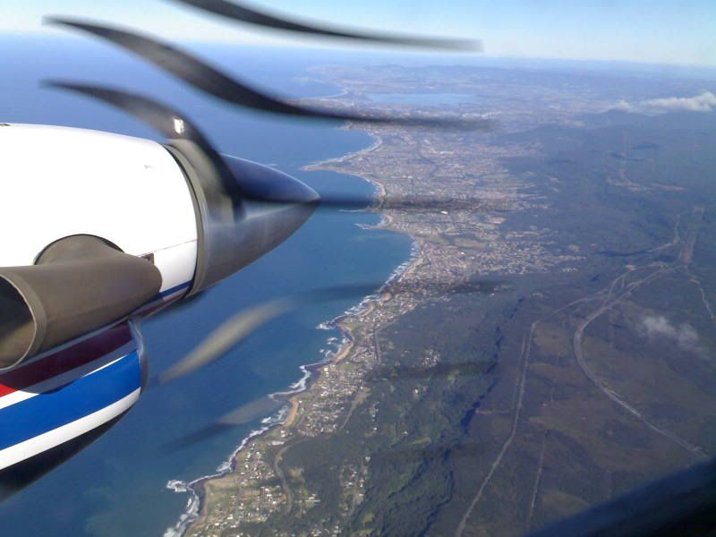
Another day at the office, that's my place just down there, can you see it?

Pseudo, I wasn't actually the one flying there, . Best you speak to the Captain of the day about that. The one on my side was simply so that he didn't get us lost, .
morno
. Best you speak to the Captain of the day about that. The one on my side was simply so that he didn't get us lost, .morno
Jaba and FTDK, sorry guys. I have never been there. So I am not worthy of the beer. just good use of a good map program.
Once you put your track in I just worked along the rough track until I found station that had the rough features. Runway between two creeks with homestead on east side of creek. Then just used the 3D view with my satellite data to get the same perspective as the photo to confirm it.
Google says it is interesting for- A previous owner was the subject of a Slim Dusty ballad. A complex of mound springs. And , a possible find of diamonds.
The station is still in operation so I guess that is why the strip looks in good nik.
PS If ever up that way would like to share a beer and a yarn Beer and Steak at the Brekkie? Doesn't get any better than that
Once you put your track in I just worked along the rough track until I found station that had the rough features. Runway between two creeks with homestead on east side of creek. Then just used the 3D view with my satellite data to get the same perspective as the photo to confirm it.
Google says it is interesting for- A previous owner was the subject of a Slim Dusty ballad. A complex of mound springs. And , a possible find of diamonds.
The station is still in operation so I guess that is why the strip looks in good nik.
PS If ever up that way would like to share a beer and a yarn
Beer and Steak at the Brekkie? Doesn't get any better than that
Join Date: Jul 2007
Location: in the classroom of life
Age: 55
Posts: 6,864
Likes: 0
Received 1 Like
on
1 Post
Pseuds.....that one looks like its from Tinpis's era and too complicated!
OZBUSDRIVER you just lost a beer out of that carton, the Lat and Long you posted is way to the East of our track. The comment about the location past the old railway suggests you have it nailed.
Nice pic HH, could you circle your house for us!
and too complicated!OZBUSDRIVER you just lost a beer out of that carton, the Lat and Long you posted is way to the East of our track. The comment about the location past the old railway suggests you have it nailed.
Nice pic HH, could you circle your house for us!
