


It's May 1941, it's night, you have to land, but how?

Thread Starter
Join Date: Jan 2012
Location: Newcastle
Age: 68
Posts: 36
Likes: 0
Received 0 Likes
on
0 Posts
It's May 1941, it's night, you have to land, but how?
Hi All – I don’t know if this is the right forum to ask this question but here goes!
I’m looking into the crash of a Stirling Bomber in May 1941 at 02:00, he was 3 miles from his home aerodrome and was returning from a bombing raid. Met office says that it was clear weather, quarter moon, cloud base was 4,000 ft. His undercarriage was down and he was only about 2 degrees azimuth off the centreline of the runway. He hit trees at 30 ft above the ground; the ground itself was 150 ft above the height of his airfield. He had 800 Hours flying time and had been a Cranfield graduate before the war. He had contacted the tower by R/T at some point (while less than 30 miles away) and had nothing to report. He was the only aircraft near the field the next aircraft was 15 minutes behind him.
I believe that the airfield only had gooseneck flares and probably a Chance floodlight. It was not a DREM site at that time. While the Stirling had the relevant aids such as DF and SBA the airfield apparently didn’t have the relevant ground systems.
I’m not trying to find out more about the aircraft, crew or the airfield. I’m not trying to work out or speculate why he crashed (though that is the next step).
I would like to know what the procedure was for landing under such conditions. It seems to me to be a task equal in danger to the actual bombing they did but I can find very little about it on the Internet – unless you know more!
At the moment I have pieced together the landing sequence but it is very sketchy:
1. Start: Coming from the mission. The field is less than 30 miles away, he is roughly at right angles to the runway. The pilot radios the field, I know he did this but what would he have said to the tower? What sort of conversation would have gone on? I believe that an important item would have been the QFE(?) given to him by the Tower stating the atmospheric pressure at the field.
2. Approaching the airfield. How soon would he have been able to ‘see’ the runway. What would he have seen?
3. Turns to fly parallel to the runway but ‘upwind’ ie in the direction he would be landing in. Would he have used the gooseneck lights to do this?
4. Turns 180 degrees and flies back downwind, again parallel to the runway. Would he have seen and used the gooseneck lights to fly with? I assume that he would have noted his heading.
5. He flies away from the field on the same heading, at least 3 miles. Was that too far or was it reasonable? Would he have flown that far to be ready to line up for the landing? At 120mph that would have been just 90 seconds of flight. Would he have lowered his undercarriage by now?
6. He performs a 180 degree turn to line up to fly back and land. When would he lower his flaps?
7. At what distance would he have seen the Gooseneck flares? The Chance light would have come on at some point – but when?
I want to make a 3D animation of the event and I want to be accurate or failing that at least realistic! I guess I need a 1941 pilot to answer these but I’m reaching out to anyone who may know. It's a pilot sort of question.
Thanks in anticipation!
James

I don't own this space under my name. I should have leased it while I still could
What was the home airfield?
You seem to have worked out a clear picture of his flight path. If you have worked out the RW direction and the courses flown that would also help someone work out the sequence.
You seem to have worked out a clear picture of his flight path. If you have worked out the RW direction and the courses flown that would also help someone work out the sequence.
I'll lunch with my favorite Lanc Pilot....American who went north and joined the RCAF and wound up flying out of Teeside on Ops to Germany.
Will see what he can tell me about such things.....always intriqued to hear him talk about those days....when I can get him to do it.
Will see what he can tell me about such things.....always intriqued to hear him talk about those days....when I can get him to do it.
it was tenths in those days!

Thread Starter
Join Date: Jan 2012
Location: Newcastle
Age: 68
Posts: 36
Likes: 0
Received 0 Likes
on
0 Posts
Hi All
Thanks for the replies. I'm no pilot so need some Jargon translation!
OKTA? Tenths? Is that related to 10/10 cloud as they say? The Met Office report states "patchy (half the sky was covered) stratocumulus cloud, base around 4000ft, winds were light from the NE. Visibility was good at around 12 miles and a temp of 2 degrees"
Airfield was Oakington - but don't know what you mean by "RW direction" and "courses flown"?
SASless - Would love to hear your pilots memories - I'm also told that all the airfields had 'code names', that is when landing at Oakington you didn't use the name Oakington - would be good to have that ratified too!
Cheers All - keep it coming!
James
Hi, James.
Oktas are eighths. So 8 oktas = total cover. Tenths you've already sorted.
RW direction = runway heading.
Course flown = compass heading flown. Ignore drift for now, it's just correctin heading for wind.
Hope those help. Jus ask if any more secret words creep in.
Courtney
Oktas are eighths. So 8 oktas = total cover. Tenths you've already sorted.
RW direction = runway heading.
Course flown = compass heading flown. Ignore drift for now, it's just correctin heading for wind.
Hope those help. Jus ask if any more secret words creep in.
Courtney
Join Date: Oct 2002
Location: UK
Posts: 54
Likes: 0
Received 0 Likes
on
0 Posts
Not in a position (too young!) to answer the questions but it may help if I pose two more? What distance from the airfield did the crash happen? Was QNH used in 1941, as opposed to QFE?
3 miles downwind would be about right for a 3 deg approach.
Oops, looks like crash was at 3 miles?
3 miles downwind would be about right for a 3 deg approach.
Oops, looks like crash was at 3 miles?
Last edited by rvusa; 10th Jan 2012 at 18:13. Reason: Not looking carefully!
I don't own this space under my name. I should have leased it while I still could
James, apologies but your initial post was so descriptive that I presummed you knew much of the jargon.
Oakington had 3 runways (RW) whose directions in (mag)netic or QDM (in the radio jargon) were 230/050 (ie Southwest/Northeast), 275/095 (west/east) and 190/010 (south/north). The QDM was the magnetic heading to steer to fly parallel to the runway.
The main runway is usually the longest and into the prevailing wind ie RW 23 which was 2000 yards long. The airfield height was 40 feet above mean sea level (asl). The only obstruction noted was a church near the approach to RW 19 (ie to the north).
You have given the weather, do you have the wind direction, that would tend to confirm the RW. Also where is the crash site in relation to the airfield?
Looking at Google it looks as if he may have been on RW 050 as Bar Hill, to the SW, is about 100 feet with higher ground or about 200 feet further out.
Last edited by Pontius Navigator; 10th Jan 2012 at 18:55.
Join Date: Apr 2000
Location: UK
Posts: 314
Likes: 0
Received 0 Likes
on
0 Posts
These days we would also think in terms of human factors:
Extreme cumulative fatigue of night bombing operations.
A possible loss of concentration due to stress release after crossing the home coast having "survived" another raid.
Possible loss of situational/altitude awareness during the landing checks.
The possibility of damage, known or unknown, to the aircraft causing difficulty lowering flaps/undercarriage distracting from "flying the aeroplane".
Loss of, or damage to, one or more engines due to enemy action or fuel shortage, or damage to the airframe causing handling difficulties.
The black hole effect of a probably remote rural home airfield in the blackout of wartime leading to a loss of altitude awareness.
The list of possible contributory factors is endless. We know that many of the enormous losses suffered by Bomber Command were other than by direct enemy action.
Join Date: Mar 2008
Location: England
Age: 65
Posts: 303
Likes: 0
Received 0 Likes
on
0 Posts
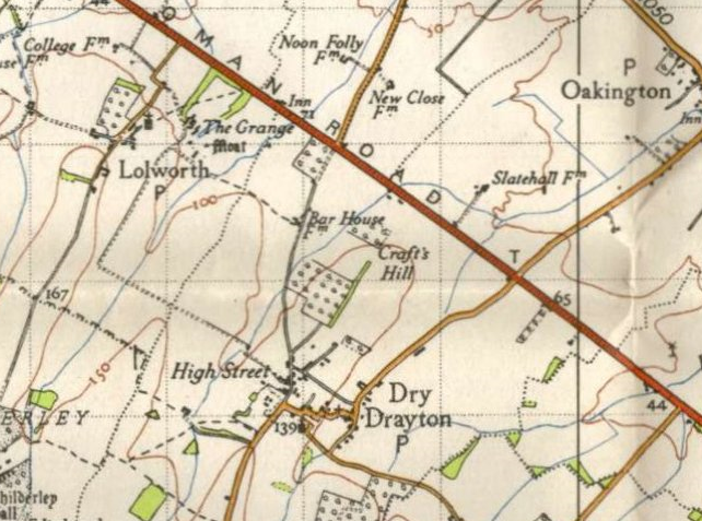
This was probably N6012 which crashed at Dry Drayton (3 miles SW of Oakington) at 0231 on 3rd May.
Lostbombers.co.uk I've found to be a useful source, it also states that the crash is probably due to damage caused by a night fighter attack.
Lostbombers.co.uk I've found to be a useful source, it also states that the crash is probably due to damage caused by a night fighter attack.
Not in a position (too young!) to answer the questions but it may help if I pose two more? What distance from the airfield did the crash happen? Was QNH used in 1941, as opposed to QFE?
3 miles downwind would be about right for a 3 deg approach.
Oops, looks like crash was at 3 miles?
3 miles downwind would be about right for a 3 deg approach.
Oops, looks like crash was at 3 miles?
Join Date: Oct 2002
Location: UK
Posts: 54
Likes: 0
Received 0 Likes
on
0 Posts
Trim Stab.
Wasn't implying an altimeter setting error, just wanted to know if QFE was in use back then?
My 3 Deg approach suggestion was more like sticking to what your normal practice would be, maybe I'm wrong?
Wasn't implying an altimeter setting error, just wanted to know if QFE was in use back then?
My 3 Deg approach suggestion was more like sticking to what your normal practice would be, maybe I'm wrong?
Join Date: Mar 2007
Location: Hertfordshire
Age: 70
Posts: 292
Likes: 0
Received 0 Likes
on
0 Posts
I have the book 'RAF Bomber Stories' edited by Martin Bowman and one story describes a landing of a Lancaster in 1945 (after the Dresden raid).
The home base was Binbrook, call sign BK and the aircraft was T - Tommy.
In this case, as they crossed the home coast at Ofordness, aircraft navigation lights were turned on. Binbrook's homing beacon, a flashing 'BK' was seen. Presumably the aircraft reported in but it doesn't say what was said. The control tower's response was a curt 'Tommy, 1,500 feet'. Permission to land was requested. They had permission to join the circuit. There were other aircraft nearby and they communicated with them too. At one stage 'Tommy' announces 'downwind'.
There appears to have been a ring of lights around the Binbrook circuit. There was a funnel to the start of the runway. Further radio messages from Tommy are 'Tommy Funnels', Tommy Pancake', 'Tommy Pancaking. Out. Full Flaps. 2,850 revs'.
I might be wrong but I get the impression wheels down and some flap applied would happen on the downwind leg.
Guest
Posts: n/a
James
If, as momoe suggests, the crash was due to fighter damage, then it may have been as the aircraft throttled back on or turning finals the decrease in airspeed manifested or made worse some control damage and perhaps the pilot lost control and it went in. Stirlings were notorious for their low service ceiling and caught a lot of flak or fighter attention.
If, as momoe suggests, the crash was due to fighter damage, then it may have been as the aircraft throttled back on or turning finals the decrease in airspeed manifested or made worse some control damage and perhaps the pilot lost control and it went in. Stirlings were notorious for their low service ceiling and caught a lot of flak or fighter attention.
Thread Starter
Join Date: Jan 2012
Location: Newcastle
Age: 68
Posts: 36
Likes: 0
Received 0 Likes
on
0 Posts
Hi All
I've done loads of research already - really now I would like to know what I can't research and that's how to land one of these Bombers at night! I am aware of a huge amount about the aircraft and have all the official reports etc.
But to take the comments as they arrived:
In 1941 there was only one runway and that was grass and camouflaged (I have a luftwaffe photo from Aug 1940). It was 230/050 and at the time was only 1700 yds long.
I would like first to understand how landings were normally done. Without aids for example how did he know how high the ground was? Whatever the altimeter said about his height above sea level or the airfield - it wouldn't tell him how high the land was below him. No point in flying at 500 ft if there is a 600ft mountain in front of you!
Wind from the NE he was landing into it I assume, he was 3 miles out.
I assume that he could set his rate of decent - but again this does not mean he knows where he is in relation to any ground object. So for example - would he fly in but stay at 1000 ft until he saw the goosenecks or the Chance light and then descend?
Hipper - I have the book - you would not believe how much I've read in search of anyone describing in detail how they landed at the time! The description you have read includes a DREM landing system where the whole countryside would have looked like a City round about at night and where the pilot could have simply looked down to find his way. I believe that my pilot may have had about 15 floppy paraffin lights to come home on! (Plus the chance?).
Am I right in that the pilot would have flown up and down in parallel with the runway? Would he have executed the 180 degree turns - or would he have 'circled'
Thanks for all the replies so far guys!
James
Join Date: Apr 2005
Location: Earth
Posts: 366
Likes: 0
Received 0 Likes
on
0 Posts
Light Levels
Light Levels may also have been a player. Here are some figures from May 1941. The figures are in Millilux. The Moon was at 25% phase and 17 degrees below the horizon on a brg of approx 330 degrees.
Can't fettle the table to display, but the light levels were at TWO at the time of the crash. (Time/Millilux) 2100/19, 2200/12, 2300/8, 0001/4, 0100/2, 0200/2, 0300/9
It was dark! (as Albert Driver mentioned)
PS The cloud cover drops the figure to 0.9. Much darker.
Can't fettle the table to display, but the light levels were at TWO at the time of the crash. (Time/Millilux) 2100/19, 2200/12, 2300/8, 0001/4, 0100/2, 0200/2, 0300/9
It was dark! (as Albert Driver mentioned)
PS The cloud cover drops the figure to 0.9. Much darker.

This story is from 1941:
BBC - WW2 People's War - 1941
Seems to indicate that the pilot would NOT have been able to see the goosenecks from 3 miles.
Pure speculation, but other possibilities include:
Mistaking a dim light in Bar House Farm for the locating bonfire, if there was one.
Mistaking a couple of cars down Bar House Farm road for the Goosenecks
(n.b. Bar Hill did not exist in 1941 - it was new-built in 1967 see below for old map
battle damage causing loss of control when flaps / gear were selected
injuries to pilot
etc.
Fighters hang around approach paths for easy kills. They did then and they still do now! We like easy kills!