


 2nd Mar 2020, 14:35 - Wikipost
|
|||
|
|||

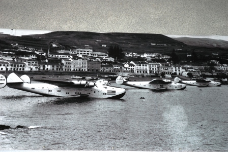
Which Aerodrome Mk III
Horta in the Azores.
Open House if correct.
Open House if correct.

Join Date: Jun 2010
Location: Newcastle
Posts: 1,063
Likes: 0
Received 0 Likes
on
0 Posts
Sorry if this seems like I'm being a party-pooper, but would it maybe be worth having a no-Google Maps rule? I know we've got no way of checking but GM seems to take a bit of the fun out of this. Apologies for the Scrooge-like comment - I do appreciate the revival of this thread by I42, nvubu an others.
Join Date: Dec 2011
Location: herts
Posts: 1,838
Likes: 0
Received 0 Likes
on
0 Posts
I agree with the no-Google Maps rule if it is the only image being posted - otherwise I've just found a host of locations when checking out all the airfields in Ireland for CGB's challenge. However, when there are old images being posted, and some of mine are 100 years old, posting the equivalent current view in b&w to show the difference/similarities can be a great/only help when things are getting sticky.
I've got one ready if no-one else wants a go
I've got one ready if no-one else wants a go
jensdad,
You raise an interesting point, which hadn't occurred to me before. I freely admit to having used Google Earth to track down posted images. In the case of Horta, my logic was:
1. I knew we were in the Atlantic but the vegetation was too lush to be Scotland or Ireland.
2. Wearing my geologist's hat, I thought the chunk of rock in the foreground looked distinctly igneous and the sloping terrain had the signature of the flanks of a volcano.
3. So I started looking at the Atlantic volcanic islands, starting with the Canaries and then moving to the Azores.
As a retroactive experiment, I tried searching for images, using "Canary airports" and then "Azores airports". It took me about the same amount of time to zero in on Horta as using Google Earth.
I'm happy to try the latter method in the future, but I'm a bit concerned the game may degenerate to a PPRuNe version of Twenty Questions:
France? Yes.
NW France? No
NE France? Yes
Lorraine? No
Alsace? Yes
and so on.
A few years ago a "frequent flyer" here was fond of doing an image search and then asking a few desultory questions before posting the answer. That MO seems to have gone away (at twice the speed of sound ), thank goodness.
nvubu,
Can you clarify your post? I don't understand.
You raise an interesting point, which hadn't occurred to me before. I freely admit to having used Google Earth to track down posted images. In the case of Horta, my logic was:
1. I knew we were in the Atlantic but the vegetation was too lush to be Scotland or Ireland.
2. Wearing my geologist's hat, I thought the chunk of rock in the foreground looked distinctly igneous and the sloping terrain had the signature of the flanks of a volcano.
3. So I started looking at the Atlantic volcanic islands, starting with the Canaries and then moving to the Azores.
As a retroactive experiment, I tried searching for images, using "Canary airports" and then "Azores airports". It took me about the same amount of time to zero in on Horta as using Google Earth.
I'm happy to try the latter method in the future, but I'm a bit concerned the game may degenerate to a PPRuNe version of Twenty Questions:
France? Yes.
NW France? No
NE France? Yes
Lorraine? No
Alsace? Yes
and so on.
A few years ago a "frequent flyer" here was fond of doing an image search and then asking a few desultory questions before posting the answer. That MO seems to have gone away (at twice the speed of sound
), thank goodness.
I agree with the no-Google Maps rule if it is the only image being posted .....
Can you clarify your post? I don't understand.
Last edited by India Four Two; 29th Dec 2016 at 03:43. Reason: typo correction
Join Date: Dec 2011
Location: herts
Posts: 1,838
Likes: 0
Received 0 Likes
on
0 Posts
I hadn't taken it to mean don't use GM/GE to search, but rather don't post an image taken from GM/GE as an Aerodrome.
This is a screenshot taken from GE of CGB's challenge - and as such I was meaning I don't think it should be used as the initial image for a challenge.

However, I think if we had been stuck, it would have been OK to post it up a bit further down the line as a clue - as I have done previously with some of my WW1 aerodromes in Alsace Lorraine.
As for using GE/GM to search for the answer, I wouldn't have found a couple of your ones without GE - following the Mackenzie River at lunchtime was a nice way to spend an hour
Re Frequent Flyers:
The one I remember didn't even bother asking the desultory questions, but rather just came out with the answer immediately - very frustrating when you have spent some time putting a challenge together with a number of follow-up images
This is a screenshot taken from GE of CGB's challenge - and as such I was meaning I don't think it should be used as the initial image for a challenge.
However, I think if we had been stuck, it would have been OK to post it up a bit further down the line as a clue - as I have done previously with some of my WW1 aerodromes in Alsace Lorraine.
As for using GE/GM to search for the answer, I wouldn't have found a couple of your ones without GE - following the Mackenzie River at lunchtime was a nice way to spend an hour
Re Frequent Flyers:
The one I remember didn't even bother asking the desultory questions, but rather just came out with the answer immediately - very frustrating when you have spent some time putting a challenge together with a number of follow-up images
Join Date: Apr 2010
Location: London
Posts: 7,072
Likes: 0
Received 0 Likes
on
0 Posts
I agree with nvubu and India 42 - no GE images for the question and let the discussion run a bit longer before providing clues....
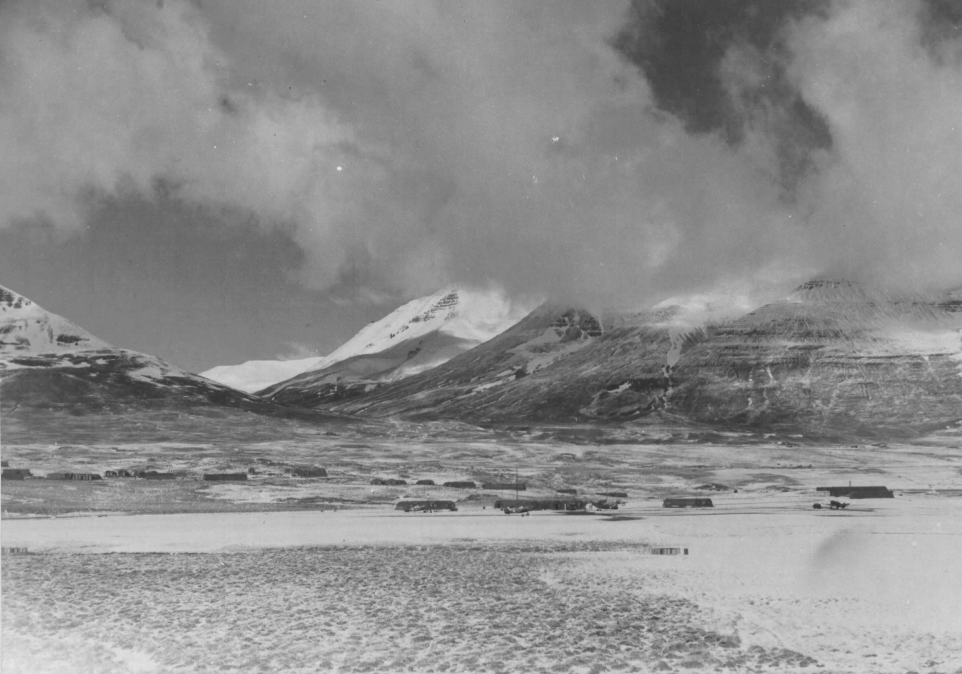
Now above those look like P39 Aircobra's to me - so maybe the Aleutians or S Alaska? Maybe Chignik Lake ??
Now above those look like P39 Aircobra's to me - so maybe the Aleutians or S Alaska? Maybe Chignik Lake ??

Join Date: Dec 2011
Location: herts
Posts: 1,838
Likes: 0
Received 0 Likes
on
0 Posts
I did Narsarsuaq a few pages back - so it isn't that one.
HH - you are very very close, It isn't the current Akureyri airfield, but is certainly prefixed by Akureyri in an accident report I've seen.
If you search for the name the image has stamped on it and is referred to elsewhere - you get an island in the Greek Islands.
edit to add:
go south young man..... but not too far.
Join Date: Dec 2011
Location: herts
Posts: 1,838
Likes: 0
Received 0 Likes
on
0 Posts
Jenkins has the name, I think HH has the location - although I'm not 100% sure of the latter.
I think it probably is where the Melgerdismalar Gliding field is now, but I found a weather website earlier today (with readings from WW2) with a Lon/Lat that put it further north and across the valley away from the mountains - which didn't look right to me. Of course, now I can't find the website
Here's another view.

So Jenkins has it for the name, but HH for the location.
I think it probably is where the Melgerdismalar Gliding field is now, but I found a weather website earlier today (with readings from WW2) with a Lon/Lat that put it further north and across the valley away from the mountains - which didn't look right to me. Of course, now I can't find the website
Here's another view.
So Jenkins has it for the name, but HH for the location.