


Which Aerodrome Mk II

Join Date: May 2010
Location: EU
Age: 82
Posts: 5,505
Likes: 0
Received 0 Likes
on
0 Posts
Interesting shot evansb and not so bad one  . The overall shape matches rather nicely, but the length of the Buran strip is a bit more than twice the challenge, and you don't see much water close to Buran strip.
Go west young man, go west
. The overall shape matches rather nicely, but the length of the Buran strip is a bit more than twice the challenge, and you don't see much water close to Buran strip.Go west young man, go west

It looks to me like an emergency landing strip. No approach lighting/aids. No significant buildings. Surrounding roads/buildings remind me of rural Russia. Nearby lake and topography suggests north Russia, somewhere near the Urals (in the background). Am I getting warm - so to speak?

Join Date: May 2010
Location: EU
Age: 82
Posts: 5,505
Likes: 0
Received 0 Likes
on
0 Posts
No, you are not getting geographically warm.
Consider the possibility (not necessarily the case, though), that the picture could be redacted.
Edit to say: To avoid being overly ambiguous, I believe it is not redacted but the pavement is very new.
Consider the possibility (not necessarily the case, though), that the picture could be redacted.
Edit to say: To avoid being overly ambiguous, I believe it is not redacted but the pavement is very new.
Last edited by RegDep; 10th Feb 2011 at 10:50. Reason: Added some clarity (I think....)
Join Date: May 2010
Location: EU
Age: 82
Posts: 5,505
Likes: 0
Received 0 Likes
on
0 Posts
Yes Eastern Europe Barry.
Edit to say: Eastern Europe, but not Russian Federation and the rest of CIS countries (as Europe was used to denote the continent of Europe in an earlier clue).
Edit to say: Eastern Europe, but not Russian Federation and the rest of CIS countries (as Europe was used to denote the continent of Europe in an earlier clue).
Join Date: May 2010
Location: EU
Age: 82
Posts: 5,505
Likes: 0
Received 0 Likes
on
0 Posts
It is Russell!
Gjakova Airport AMIKO in Kosovo
Following the 1999 Kosovo War, the airfield has been expanded and modernized by the Kosovo Force (KFOR) and is (was?) used mainly for military and humanitarian flights. Since the airfield lies in the west of Kosovo, a sector under the command of Italian forces, the airport is (was?) operated and maintained by the Italian KFOR troops (and I think that's why it was invisible in the G*ggleEarth until recently). The resolution of this pic is not great, but you can see in the front of the picture something which may be the old strip, and even some helicopters that may have been evacuated from the apron during asphalting (my speculation).
Over to you!
Join Date: Aug 2006
Location: Timbukthree
Posts: 13
Likes: 0
Received 0 Likes
on
0 Posts
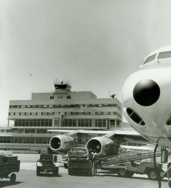
Hmm...American-made vehicles, plus the DC-8-50 Series appears to be belong to United Airlines.(So does the Convair 340 in the background). I'll guess San Franciso, California, (KSFO).
Join Date: May 2010
Location: EU
Age: 82
Posts: 5,505
Likes: 0
Received 0 Likes
on
0 Posts


 .
.
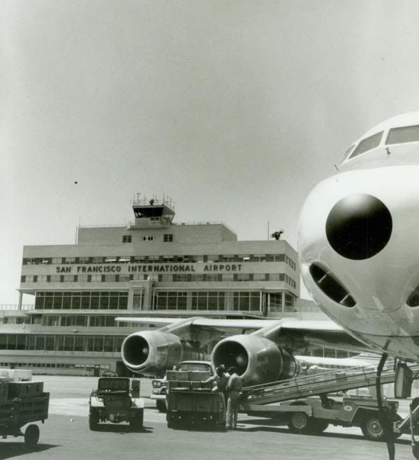
Well just for the record, evansb was correct. Here's the original picture:
and here's what it looks like more recently:
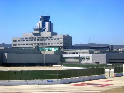
It's interesting that a large part of the original building is still extant, including what was apparently the old control tower, later overshadowed. Perhaps it's now used for ground control?
Thanks RegDep for your recognition of the rules; no harm done, so I defer to evansb's challenge.
and here's what it looks like more recently:
It's interesting that a large part of the original building is still extant, including what was apparently the old control tower, later overshadowed. Perhaps it's now used for ground control?
Thanks RegDep for your recognition of the rules; no harm done, so I defer to evansb's challenge.