


AA5342 Down DCA


Joined: Feb 2006
Posts: 29
Likes: 39
From: Germany, South-East Bavaria (Oberbayern)
Neither Lufty nor Iberia will accept a visual night approach (as far as I recall).
But that wouldn't have saved them here, since they'd still have been hit by someone else trying visual separation at night in this case.
The Lufty A380 that went to Oakland looked a lot like they were being sent there by ATC to punish them, since it can't have been news to the SFO controllers that Lufty won't do that approach - when they come there every night at about the same time. The ATC kept him waiting and the Lufty Captain was pretty arsey to the ATC and then they sent him to Purgatory (OAK).
Personally however, an LH A350 Captain myself, I would never do it at any airport that I'm not 100% familiar with. Take the Bay Area for example: there are millions of lights, from buildings, street lights, cars and other aircraft. One of the latter may or may not be your traffic, but can you be sure which one is the one? Or judge the distance from your own aircraft correctly? If ATC ask me whether I have traffic in sight, my answer is always "negative".
That American practice is inherently dangerous and, as many of my European colleagues have commented here, it is beyond me how that can be legal.

Pegase Driver

Joined: May 1997
Aviation Qualifications: ATCO
Posts: 4,448
Likes: 1,158
From: Europe
@upsidedown L I would expect the helicopter traffic to ultimately be responsible for avoidance, and they�d I guess be flying �Special VFR�*

Joined: Aug 2015
Aviation Qualifications: ATPL
Posts: 450
Likes: 300
From: The South
For ATC people a question. Would it be standard to preface the "can you see it?" with an indication of where the CRJ was? IE "Your traffic is one o'clock 2 miles...report visual etc"
Joined: Jul 2013
Aviation Qualifications: CPL
Posts: 611
Likes: 473
From: Maryland USA
Read somewhere the helicopter was a training flight ? If true is a high density , high workload and high threat environment really the place to do training ? I don’t know military training environment but this flight needed good crew crm, one operating , one looking out and working as a team . Full concentration on co ordinating ATC with traffic avoidance . If it was anything than a route famil with good crm and level command gradient it could have added to the outcome ?
Joined: Aug 2017
Posts: 96
Likes: 9
From: London
Waiting to happen
Heli route 4 is at or below 200ft if I read the chart correctly.
Approach traffic seems to be approx 400-500ft at this point.
Which turnip decided it would be OK to allow vertical separation of 300ft on a busy approach path? And allow it VFR at night?
This accident was baked in. Bound to happen at some point.
Approach traffic seems to be approx 400-500ft at this point.
Which turnip decided it would be OK to allow vertical separation of 300ft on a busy approach path? And allow it VFR at night?
This accident was baked in. Bound to happen at some point.
Pegase Driver
Joined: May 1997
Aviation Qualifications: ATCO
Posts: 4,448
Likes: 1,158
From: Europe
Same as using "side step " , a procedure made for parallel runways , here they do with with runways 30 degrees apart . etc..etc..
Joined: Jan 2010
Posts: 609
Likes: 114
From: Eagles Nest
When I was working as a CFI out of VKK, literally right outside the DCA Class B, we did training flights at DCA. It was not unusual, how were the students supposed to learn to deal with it if we never went there? One lesson was the "Big 3", going to DCA, IAD, BWI, and back home. ATC was happy enough, they surely didn't want n00bs blundering around there on their own with a fresh license and no clue.
Joined: Dec 2006
Posts: 707
Likes: 103
From: Mauritius,soon or latter
Normally I get a call like "Your traffic is at X altitude at your 3 o'clock, they have you in sight" or similar. I have flown into DCA at night and would have been more than highly surprised to have a helicopter directed to fly basically 100 feet under me, in sight or no.
Pat 25 traffic at 11 o clock 3 miles, crj following ils for rwy 33, report in sight
??

Joined: Aug 2003
Posts: 856
Likes: 30
From: Dubai and Sunderland
Might have missed it but the CRJ wasn't given any traffic on the Blackhawk?? Plus the Blackhawk was only asked if he had the CRJ insight very late on and no updated traffic information given! The ATCO was obviously concerned but that concern should have included traffic information as directly ahead of the Blackhawk was two CRJ one much further out which was no factor!!
Plus does the Blackhawk have a TCAS screen?? That would have been invaluable to pick out the traffic!
Plus does the Blackhawk have a TCAS screen?? That would have been invaluable to pick out the traffic!

Joined: Nov 2018
Posts: 58
Likes: 52
From: VA
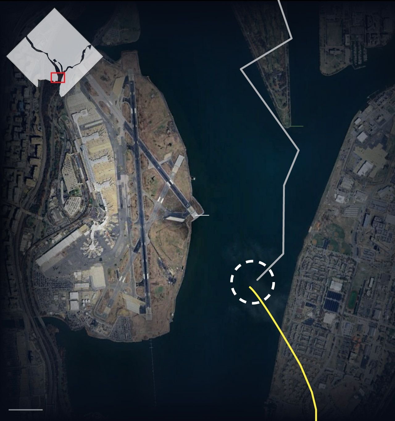
The helicopter�s right turn was directly over a golf course, not a residential neighborhood. It was probably done for noise abatement reasons, because it then turned left and proceeded down more directly over the river.
The golf course is on a peninsula in the river, so the helicopter was flying over water before and after it made the two turns.
The golf course is on a peninsula in the river, so the helicopter was flying over water before and after it made the two turns.
Joined: May 2020
Aviation Qualifications: ATCO
Posts: 151
Likes: 68
From: Magrathea
I have not read many of the earlier posts, so do not know what has been said about ATC’s involvement & whether the helicopter was operating under IFR but, it would appear that the helicopter was operating under VFR & simply being given traffic information, rather than being IFR & being properly separated from other IFR traffic (the AAL a/c in particular). If so, this accident revives the controversy about whether or not you can safely mix dense IFR traffic & VFR traffic in the same airspace. Without knowing the actual cause of this accident - there may be some other cause - it would seem to suggest that the answer to this question is, “NO, you cannot”. I remember giving traffic information to a departing HS125 , from Aberdeen, about a Cessna 150 operating within its projected flight path at up to 5,000 ft. 6 nm west of the airfield ; & being met with the reply from the 125’s pilot, “what do you expect me to do with that info ?” Thinking about it, he had a point. Simply being informed about prospective traffic does not guarantee, in any way , that you are going to be able to see & avoid it. Countless collisions between (mainly light) a/c since; plus this latest tragedy; would seem to prove the point !
See and avoid

Joined: Mar 2003
Aviation Qualifications: PPL
Posts: 757
Likes: 131
From: USA
The track in your image is not an accurate representation of PAT25s actual flight path. The leaked ATC radar track here and the VASAviation recreation here are more representative. There was no sharp RH turn to cross over the Potomac Park golf courses, it was a gentle RH turn to follow the published Route 1 to Route 4 helicopter transition around DCA.
You could contact them if you want and tell them it�s wrong. No offense intended.
Even if it wasn�t a sharp turn, it was done over a golf course and their flight path was probably dictated by noise abatement reasons, as are those flown by jets flying into DCA.
Joined: Nov 2010
Posts: 206
Likes: 91
From: Canada
Blackhawk comms
Some of the ATC recordings and YouTube videos don�t show the Blackhawk responding to ATC instructions. The Blackhawk does acknowledge more than once they have the traffic in sight - just on a different frequency, likly UHF which commercial planes do not use generally.
It�s easy to look now and be like - who would allow a helicopter highway 300 feet below a final approach path????
but this has been completely routine in that area for years and years. Helicopter Pilots who have flown the route have felt wake turbulence when scooting under/behind.
also - the use of 33, especially by CRJ size jets is completely normal and should of been expected by any helicopter crew as a possible traffic issue. In the VAS channel ATC video linked above. There are other jets using 33.
Joined: May 1999
Aviation Qualifications: Military
Posts: 16
Likes: 4
From: flat & wet
my earlier point related to responsibility for separation�. and that the helo would be VFR (if following the low-level transit Route 4) and the airliner IFR. I was unsure if there was a special category for VFR at night�
apologies for sowing any confusion��
Joined: Oct 2002
Aviation Qualifications: PPL
Posts: 8,201
Likes: 347
From: London UK
It wasn't on the ILS, it was doing a circling approach having come down the 01 ILS, then swinging round. They seem to have only been getting aligned with their runway at around 400', at the point of the collision.
Joined: Apr 2005
Posts: 141
Likes: 15
From: yyz
yeah,atc had nothing to do with this ;( https://www.youtube.com/watch?v=bHBKptJWXtU
Joined: Feb 2005
Posts: 2,411
Likes: 2
From: USA


Joined: May 2002
Aviation Qualifications: ATP+Mil
Posts: 18,633
Likes: 1,072
From: Downeast
TCAS for the helicopter....hmmmmmm.....I am at 200 feet per the Routing Requirement.....would I suppose Airplanes might be above me even if on a conflicting flight path?
How much higher at a minimum should they be over the required flightpath for the Helicopter Low Level route (at that point I see it as being 200 feet AGL or below)
But indications seem to show the Helicopter not at the required height above ground....although that number has some doubts due to various reasons.
Do standard IAP Procedures by Airlines require use of Glide Slope information even when VFR.....which would make me ask the question what height the RJ should have been at at the point it collided with t he helicopter.
Was the RJ Crew using Glide Slope information as part of their VFR Approach procedure for the designated runway? The CVR will let us know that in time probably.
The other question is at what point would the RJ Crew have benefit of visual glide slope lighting for the RWY 33?
Any of you Airline Pilots care to address that issue and assess that for us.
Here is the Airport data for Reagan International that shows the Instrument Approaches that are available. Can one derive a reasonable height above ground for the collision point....and/or a distance from the Touchdown Point of RWY33 for comparison to what seems to be the height and distance from the TD point?
https://www.airnav.com/airport/KDCA
Joined: Jan 2008
Posts: 1
Likes: 9
From: Cambs Uk
The best safety systems try to remove humans from critical procedures.
Visual separation at night is a third world solution to a busy traffic zone.
.
Visual separation at night is a third world solution to a busy traffic zone.
.
Last edited by Pilot DAR; 30th January 2025 at 13:57. Reason: removed the politics from the post