


AA5342 Down DCA


Joined: Sep 2001
Aviation Qualifications: CPL
Posts: 2,783
Likes: 203
From: Toronto
I suspect the NYTimes simulation did not adjust the helicopter heading for crosswind drift correction + the wind aloft could easily be double the DCA reported wind.
The CRJ FDR should allow the NTSB to determine the wind aloft at time of collision.
The CRJ FDR should allow the NTSB to determine the wind aloft at time of collision.


Joined: Dec 2020
Posts: 102
Likes: 87
From: USA
Helicopter heading would affect where the picture appeared in the windows, but the actual picture itself is invariant under heading. Of course if the heading was such that the picture was behind the window pillar, then it would raise even further questions about the reflexive requests for visual separation and reinforce the notion that the helicopter had a reasonable assumption that a published heliroute would keep it deconflicted from landing traffic.
I'm more familiar with the London Heliroutes (see earlier posts on this thread) where the only time you'd be asked to accept visual separation is from opposite direction helicopter traffic also on the routes. You simply wouldn't get a clearance to start on any route unless all helicopters involved had already accepted visual separation. A helicopter would never need or ask for visual separation from fixed wing traffic, because the routes are designed and operated to achieve procedural separation.
I'm more familiar with the London Heliroutes (see earlier posts on this thread) where the only time you'd be asked to accept visual separation is from opposite direction helicopter traffic also on the routes. You simply wouldn't get a clearance to start on any route unless all helicopters involved had already accepted visual separation. A helicopter would never need or ask for visual separation from fixed wing traffic, because the routes are designed and operated to achieve procedural separation.
Joined: Dec 2007
Posts: 952
Likes: 447
From: same planet as yours
For the first NYT simulated helicopter view, there was (is) no reliable/precise tack info publicly available, the MLAT track that has been overly (ab)used, is a very rough indication only. And the planned Route1->4 transition trajectory is a curved one, anyway.
But it was a good attempt to provide a visualization of what the UH60 pilots were (most likely) confronted with, and a very good attempt at countering public reactions as "how can you miss a landing airliner on a clear night"
Joined: Mar 2022
Posts: 74
Likes: 39
From: Nearby
Likewise ATC controllers ought to be a bit more sceptical whether they really believe a pilot who calls visual with traffic in amongst a whole bunch of other lights 7miles away at night!

Joined: Mar 2015
Posts: 905
Likes: 319
From: Virginia, USA
Joined: Dec 2007
Posts: 952
Likes: 447
From: same planet as yours
And I think you can drop the "visually".
For the ATCO, there wasn't only the flow of arrivals, but a good number of (no delay) departures, all this on intersecting runways and, not shown on the screenshot, in the seconds (a few dozens of...) prior to the accident, the ATCO was handling at least 3 helicopters (Mussel7 / Medevac / PAT25), even not counting the police helicopter working in the SW corner as depicted in the screenshot.
And all this on three* separate frequencies, not fully cross coupled, so TWR was receiving on several occasions, simultaneous/parallel incoming R/T calls (* based on info from other posters in both threads here on pprune & NTSB info - but I still have doubts PAT25 was on UHF, although 3 or 2 freq's, doesn't really matter in this accident's context)
And simulations by VASAviation and the likes, are heavily edited (as they correctly indicate in their comments), so they easily give the impression that traffic and R/T comm's were relatively light...

Joined: Dec 2006
Posts: 314
Likes: 22
From: Whanganui, NZ
Joined: May 2020
Posts: 63
Likes: 30
From: Virginia, USA
First of all: I can largely follow your Maths. In a straight line the PAPI is a bit less than1550m from the Eastern bank of the Potomac on a straight 328� course. At 3� this would be 270ft altitude when crossing the -east bank. Both aircraft ended up in the Potomac. When looking at the point of impact of the Blackhawk in the Potomac in these videos I end up with a spot ~1450m from the PAPI.
On the other hand the collision will have somewhat altered trajectory of both aircraft, so maybe the collision had still occured over land and due to the lateral energy transfer the Helicopter was thrown off its original course towards the West and into the river. We will get this information finally.
And in the end it doesn't really make that much of a difference wrt the level of lunacy of this whole setup.
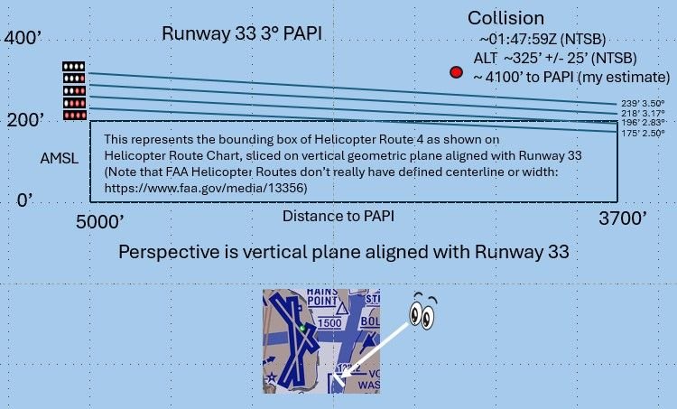
Collision Altitude vs PAPI
Having been in a mid-air collision with similar geometry, I would bet it was only normal input to approach path. FDR’s are incredibly sensitive recorders. I have a vague memory of the other plane’s wing flashing by. It looks slow in the videos, but it’s incredibly fast.
Last edited by airplanecrazy; 11th February 2025 at 05:30. Reason: Problem with picture. Awkward phrasing
Joined: Jun 2009
Posts: 801
Likes: 74
From: Germany
And all this on three* separate frequencies, not fully cross coupled, so TWR was receiving on several occasions, simultaneous/parallel incoming R/T calls (* based on info from other posters in both threads here on pprune & NTSB info - but I still have doubts PAT25 was on UHF, although 3 or 2 freq's, doesn't really matter in this accident's context)
And simulations by VASAviation and the likes, are heavily edited (as they correctly indicate in their comments), so they easily give the impression that traffic and R/T comm's were relatively light...
https://www.npr.org/2025/01/30/nx-s1...ntroller-radio

Joined: Jan 2025
Aviation Qualifications: Non-Aircrew
Posts: 639
Likes: 776
From: New Zealand
This kind of smells like a "gentleman's agreement" to me, if not implied threats of retaliation.
Speculation: The helicopter crews know that if they don't report traffic in sight as soon as it's called, they'll be slowed down and deprioritised by ATC and eventually held back until they either do report the traffic, or there's a substantial gap in arrivals - see the LH A380. That makes them unpopular with their passengers and/or superiors, so they are very flexible with what 'in sight' means.
ATC likewise knows that if they push helicopter crews too hard on altitude busts, report anything involving a helicopter, or hold up either kind of traffic, they might get people breathing down their neck and certainly nothing good comes of it.
Calling traffic immediately and not enforcing separation too strictly allows both parties to 'get on with their jobs' while looking more-or-less by-the-book - until an incident like this happens.
I'm hopeful I'm wrong, but given there seems to be a long history of near misses and altitude busts this seems like the obvious conclusion. No-one high-up wanted to hear about it or change anything, because no-one had died yet.
On a slightly different note, I'm curious whether anyone is familiar with the Hierarchy of Controls by NIOSH? It doesn't map 1:1 to aviation, but it codifies some things that are 'obvious' in hindsight:
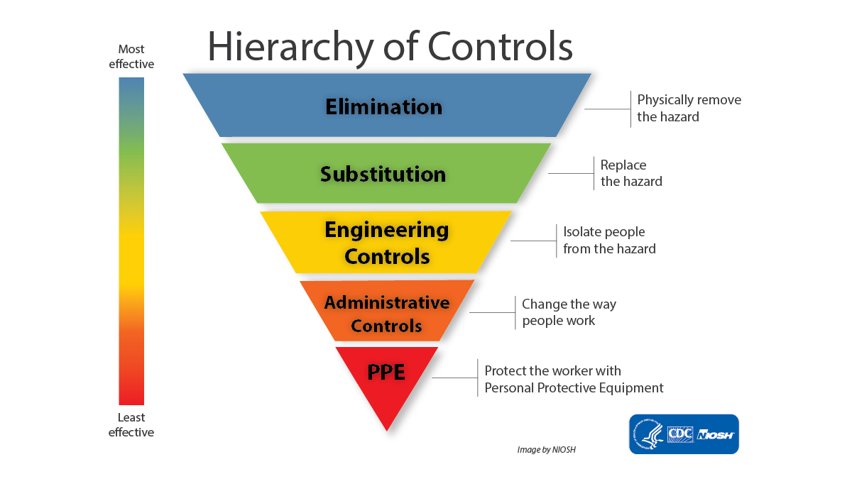
Broadly speaking, some controls are more effective than others. Wherever possible, you should attempt to use more effective controls in place of less effective ones. More effective means not just that it reduces the risk the most, but also the most reliable over time and most resistant to having rules bent, being left broken, being ignored due to alarm fatigue, or 'normalisation of deviation'. Procedures that assume everything is working perfectly and everyone is 100% competent will fail; see MCAS and a great number of other accidents.
Elimination is rarely possible but substitution (radar vs visual) and isolation (separate helicopters from other traffic) amongst other engineering controls are potentially more feasible, and much higher up the hierarchy than a glorified instruction not to crash (the very bottom of administrative). Engineering a problem out of existence is far superior to having a procedure to fix it in the QRH.
I list things like TCAS, GPWS, RSAs, and crash-proof seating as broadly being under PPE: they're nice to have and certainly worth pursuing, but unless there is no other alternative, they should never be your primary protection. Something has gone wrong if they get used.
Speculation: The helicopter crews know that if they don't report traffic in sight as soon as it's called, they'll be slowed down and deprioritised by ATC and eventually held back until they either do report the traffic, or there's a substantial gap in arrivals - see the LH A380. That makes them unpopular with their passengers and/or superiors, so they are very flexible with what 'in sight' means.
ATC likewise knows that if they push helicopter crews too hard on altitude busts, report anything involving a helicopter, or hold up either kind of traffic, they might get people breathing down their neck and certainly nothing good comes of it.
Calling traffic immediately and not enforcing separation too strictly allows both parties to 'get on with their jobs' while looking more-or-less by-the-book - until an incident like this happens.
I'm hopeful I'm wrong, but given there seems to be a long history of near misses and altitude busts this seems like the obvious conclusion. No-one high-up wanted to hear about it or change anything, because no-one had died yet.
On a slightly different note, I'm curious whether anyone is familiar with the Hierarchy of Controls by NIOSH? It doesn't map 1:1 to aviation, but it codifies some things that are 'obvious' in hindsight:
Broadly speaking, some controls are more effective than others. Wherever possible, you should attempt to use more effective controls in place of less effective ones. More effective means not just that it reduces the risk the most, but also the most reliable over time and most resistant to having rules bent, being left broken, being ignored due to alarm fatigue, or 'normalisation of deviation'. Procedures that assume everything is working perfectly and everyone is 100% competent will fail; see MCAS and a great number of other accidents.
Elimination is rarely possible but substitution (radar vs visual) and isolation (separate helicopters from other traffic) amongst other engineering controls are potentially more feasible, and much higher up the hierarchy than a glorified instruction not to crash (the very bottom of administrative). Engineering a problem out of existence is far superior to having a procedure to fix it in the QRH.
I list things like TCAS, GPWS, RSAs, and crash-proof seating as broadly being under PPE: they're nice to have and certainly worth pursuing, but unless there is no other alternative, they should never be your primary protection. Something has gone wrong if they get used.
Joined: Dec 2007
Posts: 952
Likes: 447
From: same planet as yours
as indicated by several others (but without formal proof ufn) the Route4 / RWY33 APP combination was never designed to give any vertical separation nor protection. So "their airspace" (=CRJ's) was the normal approach sector/path for a RWY 33 approach, without any relation to the 200ft max (recommended?) on the Heli route
my underline could well be the correct conclusion, hence the "no vertical protection" of the route design
Pegase Driver

Joined: May 1997
Aviation Qualifications: ATCO
Posts: 4,448
Likes: 1,158
From: Europe
Bill Fly wrote : If the ATC controller has a conflict warning (STCA) he shouldn't just ask or confirm if traffic is in sight but call out immediately "Conflict Warning, take evasive action". Preceded by respective callsign this could save lives.
Joined: May 2020
Posts: 63
Likes: 30
From: Virginia, USA
I’m not sure your quoting FAA helicopter routes as having no defined centreline or width would strictly apply in DC versus what they wrote about the North Shore of Long Island route in NYC where they are required to be 1 mile off the shoreline. As shown on the published helo chart (DIBO’s post #863, and your little chart insert) and in writing (BuzzBox’s post #998) Route 4 directs traffic to track “via the east bank of the Potomac” from the Wilson Bridge to Anacostia River. If the impact point was 1000 feet or so (give or take some trig) from the east bank of a 3000 feet wide river at that point wouldn’t this mean that PAT25 was not only too high but off track too? Otherwise according to your graphic even at 200 feet max elevation, being that distance from the east bank any helicopter not maintaining visual separation could collide if an AC was still positioning itself from being low on the glideslope.
DCA Helicopter Routes
Given these chart differences, I wonder how far a helicopter can stray from the various depictions of a route before it is considered a pilot deviation? Perhaps the NTSB will give us some insight with their accident report.
Last edited by airplanecrazy; 14th February 2025 at 22:53. Reason: Emphasize the route "appear"
Joined: Oct 2006
Posts: 289
Likes: 150
From: Too far South
I'm not pointing the finger of blame at anyone - merely asking why the DCA procedure seem so lax to a controller from another part of the world.
Meanwhile how am I supposed to understand the DCA way of doing things if I can't ask a question about the procedures in place and then read the answers to learn about them?
When it comes to flight safety I was always told there is no such thing as a a stupid question.
Pegase Driver
Joined: May 1997
Aviation Qualifications: ATCO
Posts: 4,448
Likes: 1,158
From: Europe
Lomon , asking questions is fine , but have you listened to the R/T in any busy airport in the US like DCA is ? the traffic levels and the phraseology , or slang I would say used, ?This not ICAO land with little traffic . The guy here was trained to work like this , single position , 2 runways and VFRs crossings on 2 different frequencies. Your suggestion of what he should have said like " if not sighted do that ,etc," does not fit in here . No time for long sentences,,. The procedures were completely wrong , not the controller...
Absolutely , but you were not asking a question , you were making suggestions on what the controller could have done ,.
When it comes to flight safety I was always told there is no such thing as a a stupid question.
Joined: Nov 2010
Posts: 127
Likes: 24
From: USA
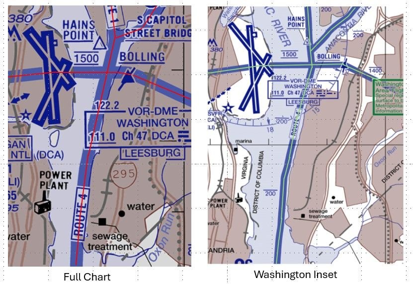
My understanding is that the FAA depicted width of a helicopter route is governed by the following doc: https://www.faa.gov/air_traffic/flig...2-complete.pdf. It specifies that on a fully printed chart the route should be 0.1 inches wide regardless of chart scale. The chart I pulled from was 1:125,000 scale (full chart size is 51x33 inch poster), which would mean the routes appear to be 125,000 * 0.1 / 12 = 1,042 ft wide. In the same FAA chart package https://aeronav.faa.gov/visual/12-26...-Wash_Heli.pdf, the third page is a "Washington Inset" with a scale of 1:62,500. In that inset the routes appear to be 62,500 * 0.1 /12 = 521 ft wide. Also, if you look at the centerlines of the routes depicted on those two pages (which I "drew in" below), they do not exactly match. For example, look at how the full chart shows the route going east of Hains Point while the inset shows it very close to Hains Point.
DCA Helicopter Routes
Given these chart differences, I wonder how far a helicopter can stray from the various depictions of a route before it is considered a pilot deviation? Perhaps the NTSB will give us some insight with their accident report.
DCA Helicopter Routes
Given these chart differences, I wonder how far a helicopter can stray from the various depictions of a route before it is considered a pilot deviation? Perhaps the NTSB will give us some insight with their accident report.
"...FAA depicted width of a helicopter route is governed by the following doc: https://www.faa.gov/air_traffic/flight_info/aeronav/iac/media/IAC15/IAC-15-22AUG2022-complete.pdf "
I think that the "width" that you are referring is for the chart maker but not the actual width of a helicopter route.
I can't find in any FAA document a definition of the lateral extent of a helicopter route. Is there one?
There are inconsistencies between the "DESCRIPTION OF ROUTES AND ALTITUDES" and the charts themselves. The Merriam-Webster's 11th Collegiate Dictionary definition of "BANK 2 : the rising ground bordering a lake, river, or sea or forming the edge of a cut or hollow."
for example "RT. 4: ... VIA EAST BANK OF POTOMAC RIVER..." while the chart depicts RT. 4 over the POTOMAC RIVER not over the ground bordering the river.
while "RT. 15: ... ALONG THE WESTERN SHORE OF THE CHESAPEAKE BAY AND PATAPSCO RIVER..." and the chart depicts RT. 15 over water.
Last edited by airman1900; 11th February 2025 at 21:33. Reason: punctuation and quote
Joined: Feb 2015
Aviation Qualifications: ATPL
Posts: 125
Likes: 246
From: The black woods
I am sorry you see a witch hunt in my post. It was supposed to be an idea for a future improvement, rather than a criticism of the very hard worked man who was on the job. On the flying end, there is quite a rigid procedure to follow if a TCAS RA goes off. From posts since I see, that there seems to be one for for STCA triggers too. It seems to me that the gravity of the situation is brought faster to a pilot's attention if the Conflict warning is announced on the RT.
That is just one factor in this sad affair of course. Both TCAS and STCA are last ditch saviours but only if full attention can be paid to them.
Joined: Feb 2019
Posts: 455
Likes: 455
From: New jersey
From a US Military helicopter pilot. I asked him if there were lateral limits to these helicopter routes? Here’s his answer,
There are routes and zones around DC. The routes you have to stick to, if you need to deviate laterally you're supposed to get permission to deviate. The zones, you can fly wherever your heart pleases but you have yo stay below the maximum altitude. You're never supposed to go above the altitude listed on the map.
As for the lateral confines for the routes, they're marked on the map buy a solid blue line. Otherwise known as the route.
As for the lateral confines for the routes, they're marked on the map buy a solid blue line. Otherwise known as the route.
Last edited by T28B; 13th February 2025 at 14:13. Reason: fixed bad formatting
Pegase Driver
Joined: May 1997
Aviation Qualifications: ATCO
Posts: 4,448
Likes: 1,158
From: Europe
Hi, ATC Watcher,
I am sorry you see a witch hunt in my post. It was supposed to be an idea for a future improvement, rather than a criticism of the very hard worked man who was on the job. On the flying end, there is quite a rigid procedure to follow if a TCAS RA goes off. From posts since I see, that there seems to be one for for STCA triggers too. It seems to me that the gravity of the situation is brought faster to a pilot's attention if the Conflict warning is announced on the RT.
That is just one factor in this sad affair of course. Both TCAS and STCA are last ditch saviours but only if full attention can be paid to them.
Now on the Conflict alert on the BRITE display . I have no first hand info on the SOPs in DCA on how a TWR controller uses the BRITE and if STCA are even displayed . `, but if they are, seen the charts and the routes , I guess STCA alerts are very common .especially when you delegate separation and you then play with a couple of hundred feet, vertical separation Too many unnecessary alerts equals normalization of deviance, . Look at the Haneda preliminary report , same ..
Finally since you mention TCAS RAs , there is a major difference with STCA , it is not the same as a TCAS RA . With an RA , as a pilot you have to react and follow , it is mandatory , for a controller a STCA is just an alert , just like a TCAS TA , if in your judgement it will pass you will not do anything , and if you have already issued a correcting instruction ( heading, level , etc,,) or here delegate visual separation , the STCA just becomes a nuisance. .
I sincerely hope the DC Controller will not be made the scapegoat of this accident . Not so sure it will not.
Joined: Dec 2006
Posts: 707
Likes: 103
From: Mauritius,soon or latter
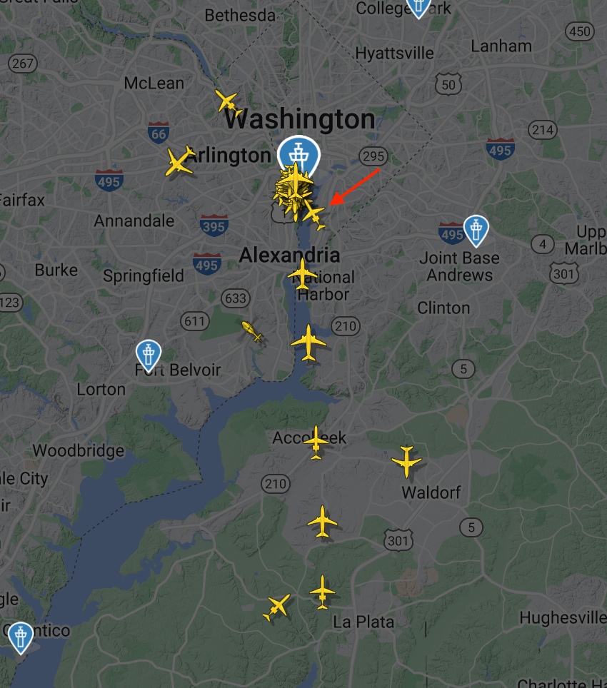
The situation was actually more visually complicated. Screenshot below is about 5 seconds prior to collision with red arrow pointing at 5342 turning into 33. There are 5 aircraft on final for 1 with a 6th joining the parade. AAL 3130 is over the Wilson Bridge and as I recall, UAL 472 next with a couple more JIAs in the stack. Adding to the background against which PAT25 is target hunting is National Harbor with some lesser contribution from the Naval Research Lab and Blue Plains.
One ATCO, worked , at three separate frequency, three runways, 6 aircraft for arrival 01, one a/c 33, plus three helicopter, plus how many departures ( both active and approaching/crossing active runways) ?
Plus active estimate for a few aircraft more?
Ground vehicles, any?
