


UPS cargo crash near Birmingham AL

EGPWS inhibits
EGPWS only detects those ‘obstacles’ which are in the obstacle database; assuming that the option is fitted/selected and updated.
Normally there should not be any need to deactivate the ‘enhanced’ terrain features. However, rarely with new runway ends or change of circumstance, unwarranted alerts can be given; these should be notified to the system manufacturer who can modify the terrain database or provide a local GPS/FMS based alleviation.
Even if the terrain feature is inhibited then the baseline GPWS detection and alerts should still be active; which would be consistent with the NTSB briefing on the ‘Sink Rate’ alerts.
Edit: Sink Rate
SC Thanks: a typo from an earlier post where this was discussed – NTSB video briefing stated ‘Sink Rate’.
Last edited by Jetdriver; 25th Aug 2013 at 20:11.

Join Date: Apr 2010
Location: dunno
Age: 52
Posts: 88
Likes: 0
Received 0 Likes
on
0 Posts
The aural warning was "sink rate", which occurred twice (from NTSB brief). We can assume they were coming down at more than 1000'/min for that to happen. (a 3.25 deg CDA at 140ish kts would give a 800 fpm). "Terrain, Terrain" would be the proper warning for excessive closure rate ie RadAlt.
PEI, "Don't Sink" warning are on take-off and go-around only.
I wish the NTSB had provided the vertical mode in use.
PEI, "Don't Sink" warning are on take-off and go-around only.
I wish the NTSB had provided the vertical mode in use.
Join Date: Aug 2013
Location: Birmingham, AL
Posts: 18
Likes: 0
Received 0 Likes
on
0 Posts
mm43, I'm more interested in the sight angle of that bridge from UPS just before the troubles. I have a crazy idea that they may have mistook stalled morning rush hour traffic on this bridge - a mix of red and white lights - for the PAPI. The highway stands at a rather acute angle to the runway so this is possible.
I live ten miles from the accident site. I frequently drive in to the airport at o'dark thirty. I don't believe there was much traffic on the I-20/59 interstates at that hour. Not saying it couldn't happen, but...
I'm more interested in my brother-in-law's account: He drove to work at an auto shop about 5 miles from the accident, about a half-hour later (5:30). He says the ditches were filling up with fog....
I'm more interested in my brother-in-law's account: He drove to work at an auto shop about 5 miles from the accident, about a half-hour later (5:30). He says the ditches were filling up with fog....
Join Date: Sep 2010
Location: earth
Posts: 1,341
Likes: 0
Received 0 Likes
on
0 Posts
A quote out of an A300-600 AMM
All warnings inhibited...
GPWS FAULT/OVRD indicator
The GPWS FAULT/OVRD indicator light is located on the pilot's switching panel 402VU and provides a FAULT indication when a system failure has been detected by the GPWC. All ground proximity warnings are inhibited, and no GPWS self-test is possible. If the flap override switch 12WZ is set to the FLAP OVRD position, the GPWS OVRD lamp illuminates.
The GPWS FAULT/OVRD indicator light is located on the pilot's switching panel 402VU and provides a FAULT indication when a system failure has been detected by the GPWC. All ground proximity warnings are inhibited, and no GPWS self-test is possible. If the flap override switch 12WZ is set to the FLAP OVRD position, the GPWS OVRD lamp illuminates.
Grounded 27 are you suggesting that the Captain ( for on the A306 the switch is sited on his side of the cockpit and can only be reached by the captain) totally deactivated the gpws possibly after the second GPWS warning?
Last edited by tubby linton; 25th Aug 2013 at 22:44.
Join Date: Sep 2010
Location: earth
Posts: 1,341
Likes: 0
Received 0 Likes
on
0 Posts
No sorry that was the indicator only,
TCF though could have been inhibited.
TERRAIN SYSTEM Panels
Located at each main instrument panel (3VU, 5VU), the TERRAIN SYSTEM Panels contain the controls used to operate EGPWS Terrain Clearance Floor, Terrain Look-ahead Alerting functions and the Terrain Look-ahead displays. The TERR DISPLAY Select Switchlights allow each pilot to select the Terrain Awareness Display onto his or her respective Navigation Display. The TERRAIN OVRD/FAULT guarded Switchlights allow each pilot to override the EGPWS Terrain Clearance Floor and Terrain Look-ahead Alerting functions; GPWS Modes 1-6 are not affected. The FAULT indicator illuminates when a Terrain function fault is detected.
Located at each main instrument panel (3VU, 5VU), the TERRAIN SYSTEM Panels contain the controls used to operate EGPWS Terrain Clearance Floor, Terrain Look-ahead Alerting functions and the Terrain Look-ahead displays. The TERR DISPLAY Select Switchlights allow each pilot to select the Terrain Awareness Display onto his or her respective Navigation Display. The TERRAIN OVRD/FAULT guarded Switchlights allow each pilot to override the EGPWS Terrain Clearance Floor and Terrain Look-ahead Alerting functions; GPWS Modes 1-6 are not affected. The FAULT indicator illuminates when a Terrain function fault is detected.
Join Date: Jun 2001
Location: Rockytop, Tennessee, USA
Posts: 5,898
Likes: 0
Received 1 Like
on
1 Post
I do not understand why there is a discussion about R/A EGPWS, given an obvious obstacle it would have most likely been inhibited by the flight crew.
A quote out of an A300-600 AMM

Anyway we appreciate you sharing your obvious expertise but no, the pilots wouldn't inhibit the EGPWS if there was an obstacle on the approach.

Have you ever shot a non-precision approach in an A300-600 or any other large plane? Just curious...
Is that from a UPS AMM as that is a different config to the Terr fitted to my company A306? We only have one switch to deactivate the Terr functions and again that is on the Captain's side.
We have individual switches which control the display on the ND of terrain and even if they are not selected a terrain ahead warning will cause them to display the terrain
I would hope that a gpws warning would prompt a crew to fly an escape profile not prompt them to turn it off. Shutup Gringo taught the industry a lesson many years ago.
Last edited by tubby linton; 25th Aug 2013 at 23:03.
Join Date: Jul 2013
Location: USA
Posts: 31
Likes: 0
Received 0 Likes
on
0 Posts
Originally Posted by deSitter
mm43, I'm more interested in the sight angle of that bridge from UPS just before the troubles. I have a crazy idea that they may have mistook stalled morning rush hour traffic on this bridge - a mix of red and white lights - for the PAPI. The highway stands at a rather acute angle to the runway so this is possible.
mm43, I'm more interested in the sight angle of that bridge from UPS just before the troubles. I have a crazy idea that they may have mistook stalled morning rush hour traffic on this bridge - a mix of red and white lights - for the PAPI. The highway stands at a rather acute angle to the runway so this is possible.
Using Google earth, I compute the following:
highway altitude:+/- 640ft
Mrs Benson pine tree altitude: +/-830ft
distance from highway to pine tree: +/-14200ft
That makes for an angle of less than one degree (0.77°).
The highway altitude is somewhat below runway southern threshold (660).
If they could see the highway, it must have seemed awfully high on their windshield...
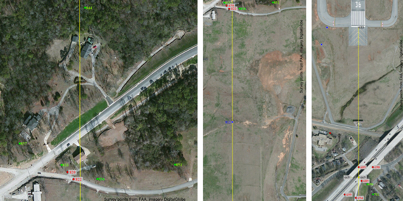
Using GIS software I plotted all of the surveyed points for BHM runway 18-36, as shown below in the reduced size extract. The numbers are the MSL elevation, in feet, of the top of the feature. Red points are man-made objects, green are trees, yellow are road surface and blue is ground. Enlarged photos and the corresponding data table are available at index of /kbhm All values in the table and photos are direct from the FAA data, which were verified in 2011, and not calculated by me.
Valvanuz’s estimates are really close except that the roadway (669 ft) is above the end of the runway (633 ft), making the calculated angle slightly less. Poles and trees near where the extended centerline crosses are up to 68 feet higher than the end of the runway.
Several trees and poles around the Benson residence and the house north of it were surveyed. One ground point on the extended centerline of runway 18 was surveyed and is shown.
Join Date: Jun 2001
Location: Surrounded by aluminum, and the great outdoors
Posts: 3,780
Likes: 0
Received 0 Likes
on
0 Posts
Possibly BHM is on the list of airports with database errors, requiring the egpws to be inhibited...or it was MEL'd but i suspect they descended into terrain at a high rate of descent from above , then descending through and below the desired flight path, and...my 2 cents worth,
Join Date: Sep 2010
Location: earth
Posts: 1,341
Likes: 0
Received 0 Likes
on
0 Posts
Sir Bubba
Anyway we appreciate you sharing your obvious expertise but no, the pilots wouldn't inhibit the EGPWS if there was an obstacle on the approach.
They were visual. There is a reason for that button.
They were visual. There is a reason for that button.
Inhibiting the EGPWS without specific instructions from manuals, NOTAMs, etc. is like turning off the TCAS if it shows an aircraft approaching. Especially at night with cloud cover, when it's hard to say you are truly visual with terrain, obstacles, etc.
Does RWY 18 at Birmingham has any official guidance in this respect? I only have performance data for 06/24...
Longtimelurker
Join Date: Nov 1998
Location: killington Vt
Posts: 391
Likes: 0
Received 0 Likes
on
0 Posts
Can't remember who I got the info from but flying a FMS GS on a non precision app below MDA does not provide terrain clearance to the runway. First thing that came to mind when I read the a/p was on at the time of the accident.
Join Date: Dec 2006
Location: Florida and wherever my laptop is
Posts: 1,350
Likes: 0
Received 0 Likes
on
0 Posts
So were they flying a FMS GS or were they flying visually with FMS GS as a check by PNF. Perhaps the trees at the Benson house and the ridge were wrapped in mist and just part of a featureless black hole with the far end runway lights just visible - hence the call runway in sight. Would seeing those distant lights in the black hole make them feel high and therefore clear of the obstacles?
Join Date: Jun 2001
Location: Rockytop, Tennessee, USA
Posts: 5,898
Likes: 0
Received 1 Like
on
1 Post
Can't remember who I got the info from but flying a FMS GS on a non precision app below MDA does not provide terrain clearance to the runway. First thing that came to mind when I read the a/p was on at the time of the accident.
The VDA [vertical descent angle] provides the pilot with information not previously available on nonprecision approaches. It provides a means for the pilot to establish a stabilized descent from the FAF or stepdown fix to the MDA. Stabilized descent is a key factor in the reduction of controlled flight into terrain (CFIT) incidents. However, pilots should be aware that the published angle is for information only - it is strictly advisory in nature. There is no implicit additional obstacle protection below the MDA. Pilots must still respect the published minimum descent altitude (MDA) unless the visual cues stated 14 CFR Section 91.175 are present and they can visually acquire and avoid obstacles once below the MDA. The presence of a VDA does not guarantee obstacle protection in the visual segment and does not change any of the requirements for flying a nonprecision approach.
Visual descent points (VDPs) provide pilots with a reference for the optimal location to begin descent from the MDA, based on the designed vertical descent angle (VDA) for the approach procedure, assuming required visual references are available. Approaches without VDPs have not been assessed for terrain clearance below the MDA, and may not provide a clear vertical path to the runway at the normally expected descent angle. Therefore, pilots must be especially vigilant when descending below the MDA at locations without VDPs. This does not necessarily prevent flying the normal angle; it only means that obstacle clearance in the visual segment could be less and greater care should be exercised in looking for obstacles in the visual segment. Use of visual glide slope indicator (VGSI) systems can aid the pilot in determining if the aircraft is in a position to make the descent from the MDA. However, when the visibility is close to minimums, the VGSI may not be visible at the start descent point for a “normal” glidepath, due to its location down the runway.
The LOC Rwy 18 at BHM has a published VDA (3.28 degrees) but no VDP so the AIM says 'pilots must be especially vigilant when descending below the MDA'.
According to the NTSB briefing the autopilot was on until one second before the end of the DFDR data. As others have noted, it would normally automatically disconnect at 50 feet below the D-DA of 1250 feet (assuming they could identify IMTOY). Technique I was taught in Toulouse years ago was to manually disconnect the autopilot ahead of time with the runway in sight so you don't get the aural warning (is it the 'cavalry charge'?).
Somehow, the plane thought it was still above 50 feet below the D-DA entered on the approach page of the FMS.
Possibly BHM is on the list of airports with database errors, requiring the egpws to be inhibited...or it was MEL'd but i suspect they descended into terrain at a high rate of descent from above , then descending through and below the desired flight path, and...my 2 cents worth,
A gross altimeter setting error on descent could sure make the crew think they were high on path. And, the controllers might not see it since at a quiet time of the night the UPS plane might get lower altitude clearances without ever leveling off.
An approach speed of 140 knots (Vref+5) would be about max landing weight for an A300 as PSJ earlier observed. However, for a freighter on a short leg, this would not seem unusual.
Configured, on speed, but thinking they were high on path, maybe chasing a bad profile downward with V/S in a futile attempt to get P.DES to go green?
Join Date: Jul 2013
Location: 12E CTY
Age: 69
Posts: 22
Likes: 0
Received 0 Likes
on
0 Posts
Has anyone matched the snapped off tree(s) shown on #470 to the where that is on the Digital Global map w/the surveyed points ? The heavy foliage behind the tree(s) almost looks the group east of the Benson property, and north of the 851 survey.
#470 http://www.pprune.org/rumours-news/5...ml#post8001294
#470 http://www.pprune.org/rumours-news/5...ml#post8001294
Join Date: Mar 2013
Location: huntsvegas
Posts: 41
Likes: 0
Received 0 Likes
on
0 Posts
autopilot ?
...According to the NTSB briefing the autopilot was on until one second before the end of the DFDR data. As others have noted, it would normally automatically disconnect at 50 feet below the D-DA of 1250 feet
Somehow, the plane thought it was still above 50 feet below the D-DA entered on the approach page of the FMS.
Somehow, the plane thought it was still above 50 feet below the D-DA entered on the approach page of the FMS.
Last edited by kenneth house; 27th Aug 2013 at 11:50.
Join Date: Jun 2001
Location: Surrounded by aluminum, and the great outdoors
Posts: 3,780
Likes: 0
Received 0 Likes
on
0 Posts
one would think the constraint at IMTOY would have been in the database....many airlines SOPs prohibit modifying any portion of the final approach if it is to be flown managed...
Trash du Blanc
Thread Starter
Join Date: Mar 2001
Location: KBHM
Posts: 1,185
Likes: 0
Received 0 Likes
on
0 Posts
SLF I have stood at that spot several times, including yesterday. The power lines are repaired and the street is open to the public.
The topped trees were at spots 820 and 822. In my estimation, judging by the trees that were topped, the fuselage did indeed follow precisely that yellow line and passed directly over the house. I estimate the fuselage cleared the roof by 10-20 feet.
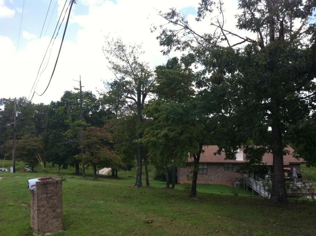
The topped trees were at spots 820 and 822. In my estimation, judging by the trees that were topped, the fuselage did indeed follow precisely that yellow line and passed directly over the house. I estimate the fuselage cleared the roof by 10-20 feet.