Originally Posted by deSitter
mm43, I'm more interested in the sight angle of that bridge from UPS just before the troubles. I have a crazy idea that they may have mistook stalled morning rush hour traffic on this bridge - a mix of red and white lights - for the PAPI. The highway stands at a rather acute angle to the runway so this is possible.
Originally Posted by
valvanuz
Using Google earth, I compute the following:
highway altitude:+/- 640ft
Mrs Benson pine tree altitude: +/-830ft
distance from highway to pine tree: +/-14200ft
That makes for an angle of less than one degree (0.77�).
The highway altitude is somewhat below runway southern threshold (660).
If they could see the highway, it must have seemed awfully high on their windshield...
The FAA makes airport survey data available:
https://nfdc.faa.gov/tpss/uddfList.jsp
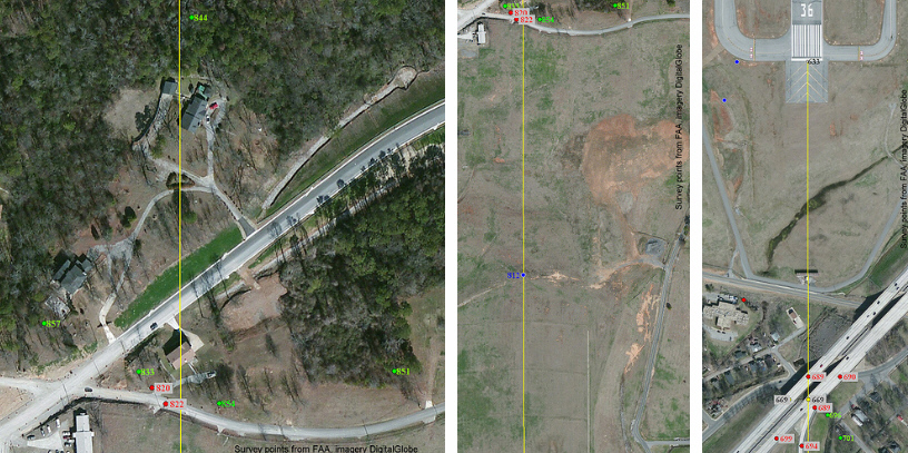
Using GIS software I plotted all of the surveyed points for BHM runway 18-36, as shown below in the reduced size extract. The numbers are the MSL elevation, in feet, of the top of the feature. Red points are man-made objects, green are trees, yellow are road surface and blue is ground. Enlarged photos and the corresponding data table are available at
index of /kbhm All values in the table and photos are direct from the FAA data, which were verified in 2011, and not calculated by me.
Valvanuz�s estimates are really close except that the roadway (669 ft) is above the end of the runway (633 ft), making the calculated angle slightly less. Poles and trees near where the extended centerline crosses are up to 68 feet higher than the end of the runway.
Several trees and poles around the Benson residence and the house north of it were surveyed. One ground point on the extended centerline of runway 18 was surveyed and is shown.