


AF 447 Search to resume

Joined: Jun 2009
Posts: 106
Likes: 0
From: Bangkok,Thailand
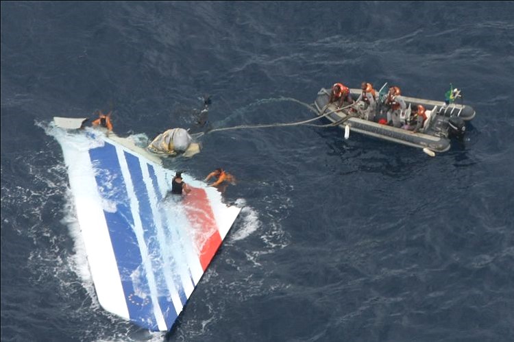
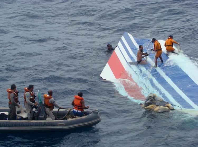
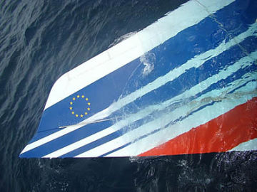
Of the almost 100,000 photos taken of the wreck and surrounding area, BEA publicized several black-and-white images of the landing gear, an engine, a wing and parts of the fuselage. While the black boxes have not been spotted, the robot has located the part of the tail that normally houses the recorders. Investigators withheld images of bodies and made them available only to researchers involved in the mission. For some, the sight was too much to bear.


Joined: Jan 2008
Posts: 2,173
Likes: 51
From: Blighty (Nth. Downs)
wes wall and SaturnV (have you seen the Haynes Manual in the UK?),
Don't have to tell you that this topic has been discussed at length on this or the old thread. With that sense of d�j�-vu, I've been trawling through the pages from this time last year, so far without success. (No doubt the antipodal mm43 will remind us later where to find it.)
SaturnV,
Regret I've no expertise in this area. Is "HYCOM" the same as the "NCOM" referred to in BEA Interim Report 2, page 79?
Looking at BEA Interims 1 & 2, I've noticed a discrepancy on the recovery position of the fin. This makes a complete nonsense of the 29-hour "voyage" (for want of a better expression) in my post above, in terms of both track and distance. Can you confirm the source of the recovery position you quoted:
"VS recovered June 7 @ 18h35 @ 3.47N 30.68W" ?
Unless I've missed it, neither report specifies the Lat/Long, but the map in Interim 1 (enlarged slightly in the Appendix, page 107) has the June7-"recovery" diamond position-symbol at about:
N03� 36'/W030� 37', i.e., in the language of your quote, 3.60N 30.62W.
That looks almost identical to the "sighted" June 6 position you quoted. Can you shed any light?
[EDITED ADDITION]: See my subsequent post (#3743 next page).
wes wall, (quote):
It assumes all have accepted the discovered site as close to the LKP, but what are we considering "close?" Given the BEA's close to the vest attitude, the "close" could mean about anything.
You say that if you like; I couldn't possibly comment...
Chris
Last edited by Chris Scott; 21st April 2011 at 17:19. Reason: Link added.
Guest
Posts: n/a
henra
Without VS/Rudder, both JAL 747 and Sioux City DC10 'landed' flat. Pilots were active and had some control, but we haven't determined that P1P2 on the deck of 447 didn't have same. So loss of directional control structure does not mean nose first dive necessarily?? 587 had lost all controls due to loss of both engine structures. 587 also had presumably alive alert pilots after VS/R loss. rgds.
Chris Scott
I still await mm43's response. He mentioned the winds at surface LKP as 000@25-30, does not this conflict with a Northerly drift of the VS. Of course that doesn't take into account the actual crash site.
Razoray
I am always hopeful of strong and important changes to the industry to emanate from the finality of such a heartbreaking tragedy. These changes are entirely dependent on BEA and their report, for they have the tools and the evidence to make this fateful flight an eternal memory of people who perished for good of others. My hope is that a new level of disclosure and openness will evolve in the results of this. Flying is uncommonly safe, and we are all human, so things go wrong sometimes. It must be made safer.
Last edited by bearfoil; 21st April 2011 at 16:09.
Joined: Mar 2001
Posts: 694
Likes: 0
From: us
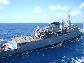
Reading between the lines of the Bloomberg articles, it would seem that Alucia and two Remus subs will rejoin the effort. I would think Woods Hole has produced a detailed mosaic map of everything, given the quantity of pictures. The question becomes, how intact is the tail, and how much cutting will be needed to access where the recorders presumably are?
Joined: Mar 2001
Posts: 694
Likes: 0
From: us
Chris Scott,
My pdf version on the BEA Second Interim report only goes to p. 72, so I can't speak to the reference you cite.
The latitude and longitude coordinates for the sightings and recoveries are from Table 1 of the
"BUREAU D�ENQUETES ET D�ANALYSES POUR LA SECURITE DE L�AVIATION CIVILE
Scientific Report from the Drift Group"
Published on June 30 2010
This is Table 1 in non-tabular format
Of the seven models the drift group used, here is the estimated crash position for each model:
Table 2 Mean crash positions and estimated standard deviations for
the seven models selected.
Lat Long Standard deviation Model
3.579 -30.869 48 ZOOM2
3.673 -30.675 48 ZOOM2+ Stokes
3.364 -30.911 35 FVCOM
3.372 -30.856 35 FVCOMW
3.554 -30.756 20 OI50
3.590 -30.537 20 OI85
3.393 -30.983 40 PSY2AVG data fitted
This is the detail on HYCOM.
NRL is Naval Research Lab @ Stennis. Its responsibilities are to function as the major center for in-house Navy research and development in oceanography, marine geology, geophysics, geoacoustics, and geotechnology. It is also the Navy�s lead activity for mapping, charting, and geodesy research and development.
My pdf version on the BEA Second Interim report only goes to p. 72, so I can't speak to the reference you cite.
The latitude and longitude coordinates for the sightings and recoveries are from Table 1 of the
"BUREAU D�ENQUETES ET D�ANALYSES POUR LA SECURITE DE L�AVIATION CIVILE
Scientific Report from the Drift Group"
Published on June 30 2010
This is Table 1 in non-tabular format
Ursulla sighting U June 5 2009 at 16h10 3.63N 30.45W
Brazilian sighting 1 S1 June 5 2009 at 21h02 3.56N 30.44W
3m part sighting 2 S2 June 6 2009 at 10h59 3.47N 30.47W
Galley G213 (sighted)G2 June 6 2009 at 11h06 3.47N 30.66W
First two bodies BB June 6 2009 at 11h55 3.57N 30.46W
Galley G2 (recover.) June 6 2009 at 15h00 3.47N 30.66W
Case June 6 2009 at 16h10 3.46N 30.63W
Body E1 (sighted) E1 June 7 2009 at 9h11 3.65N 30.51W
Vertical fin(sighted) VTP June 7 2009 at 13h38 3.61N 30.62W
Body 2Z (recover.) June 7 2009 at 16h39 3.70N 30.50W
Body 3Z (recover.) 3Z June 7 2009 at 17h17 3.73N 30.48W
Body 6Z (recover.) June 7 2009 at 17h29 3.74N 30.48W
Body 4Z (recover.) June 7 2009 at 17h41 3.75N 30.47W
Vertical fin(recover.) June 7 2009 at 18h35 3.47N 30.68W
Body 5Z (recover.) June 7 2009 at 18h55 3.73N 30.47W
Body 7Z (recover.) June 7 2009 at 20h35 3.75N 30.47W
Body 8Z (recover.) June 8 2009 at 16h58 4.04N 30.46W
Body 9Z (recover.) June 8 2009 at 17h25 4.03N 30.45W
Body 10Z (recover.) June 8 2009 at 17h50 4.06N 30.44W
Body (recover.) June 8 2009 at 18h34 4.06N 30.43W
Body (recover.) June 8 2009 at 19h25 4.08N 30.43W
Body (recover.) June 8 2009 at 19h56 4.09N 30.43W
Body 11Z (recover.) June 9 2009 at 9h45 4.25N 30.44W
Body 12Z (recover.) June 9 2009 at 10h16 4.25N 30.43W
Body 13Z (recover.) June 9 2009 at 11h02 4.25N 30.41W
Body 14Z (recover.) June 9 2009 at 12h29 4.27N 30.42W
Body 15Z (recover.) June 9 2009 at 12h56 4.27N 30.43W
Body 16Z (recover.) June 9 2009 at 13h29 4.31N 30.45W
Body 17Z (recover.) June 9 2009 at 14h21 4.31N 30.51W
Body 18Z (recover.) June 9 2009 at 15h45 4.35N 30.52W
Body 19Z (recover.) June 9 2009 at 15h45 4.35N 30.52W
Body 20Z (recover.) June 9 2009 at 16h24 4.41N 30.52
13 Not fully confirmed
Table 2 Mean crash positions and estimated standard deviations for
the seven models selected.
Lat Long Standard deviation Model
3.579 -30.869 48 ZOOM2
3.673 -30.675 48 ZOOM2+ Stokes
3.364 -30.911 35 FVCOM
3.372 -30.856 35 FVCOMW
3.554 -30.756 20 OI50
3.590 -30.537 20 OI85
3.393 -30.983 40 PSY2AVG data fitted
This is the detail on HYCOM.
This global 1/12� ocean forecasting system is run at NRL Stennis Space Center. It uses 32 vertical hybrid layers. Surface mixing is parameterized with Large et al.�s (1997) K Profile Parameterization (KPP) surface ocean boundary layer model. The surface is forced by 3-hourly wind stress, wind speed, heat flux (using bulk formula) and precipitation from the Navy Operational Global Atmospheric Prediction System (NOGAPS). Runoff from 986 rivers is included as a virtual salinity flux with no mass exchange.
The system assimilates (i) SSH from Envisat, Jason-1 and Jason-2 (ii) SST from all available satellite and in situ sources, (iii) all available in situ temperature and salinity profiles (e.g., Argo, CTDs, moor- ings), and (iv) Special Sensor Microwave/ Imager (SSMI) sea ice concentration. Assimilation is performed using the three-dimensional MultiVariate Optimum Interpolation (MVOI) Navy Coupled Ocean Data Assimilation (NCODA) system (Cummings, 2005). In this scheme, corrections to the model state are obtained by linear combinations of model-observation differences. The MVOI analysis is carried out on 42 z-levels extending from the surface down to 2500 m. The model forecast is interpolated to z-levels before the analysis and the analyzed increments are added to the forecast and interpolated back to the model's hybrid vertical coordinate.
The system assimilates (i) SSH from Envisat, Jason-1 and Jason-2 (ii) SST from all available satellite and in situ sources, (iii) all available in situ temperature and salinity profiles (e.g., Argo, CTDs, moor- ings), and (iv) Special Sensor Microwave/ Imager (SSMI) sea ice concentration. Assimilation is performed using the three-dimensional MultiVariate Optimum Interpolation (MVOI) Navy Coupled Ocean Data Assimilation (NCODA) system (Cummings, 2005). In this scheme, corrections to the model state are obtained by linear combinations of model-observation differences. The MVOI analysis is carried out on 42 z-levels extending from the surface down to 2500 m. The model forecast is interpolated to z-levels before the analysis and the analyzed increments are added to the forecast and interpolated back to the model's hybrid vertical coordinate.
Joined: Jan 2008
Posts: 2,173
Likes: 51
From: Blighty (Nth. Downs)
bearfoil, quote:
"Without VS/Rudder, both JAL 747 and Sioux City DC10 'landed' flat."
No Sir, the UAL DC10 landed at Sioux City with its fin intact, and (unpowered) rudder in place. Those guys did an absolutely brilliant job, but am confident they would be the first to say that they would never have made it without a fin.
The JAL 747 guys also did a brilliant job, but never had a chance to attempt a landing with their finless aeroplane.
Guest
Posts: n/a
I stand corrected on UAL, I recall that the disintegrating Fan severed hydraulics in the Fin, and Directional control was lost due to unpowered Rudder. This is somewhat counter to my belief that the VS is critical, the Rudder, not so. As JAL shows, I think they remained relatively in control, but meandered in heading until they impacted the mountain. My point is that a fairly level arrival is possible w/o the Fin. Again, we don't know that 447's pilots were not alert and had no management of Pitch. The fact that 447 was laterally rotating supports the loss of the Vertical Stabilizer, anent JD-EE's maple leaf (acer helix). This is not to say that 447 lost her fin at altitude, she may have lost it much lower, its loss perhaps initiating 447's lateral rotation.
587 does not apply here, imo.
587 does not apply here, imo.
Joined: Jan 2008
Posts: 2,173
Likes: 51
From: Blighty (Nth. Downs)
Thanks SaturnV,
For confirming the VS (fin) positions you originally quoted. Therefore, tentatively, the 29-hour "voyage" of the VS-rudder assembly still stands, subject to the accuracy of the "sighted" position of June 6.
Guess the map that appears twice in BEA Interim Report 1 must be wrong.
I'm wondering what effect the close-proximity of the north-migrating ITCZ (front inter-tropique) may have had on the accuracy of surface-wind estimations.
To be simplistic:
(a) with the ITCZ just south of the crash zone, would the surface-wind have been in the north-east?
(b) if the ITCZ had already passed through (say at 4� N), might the crash-site surface-wind have been between south-east and south-west?
(c) if overhead the crash zone, would it have been light and variable ("Doldrums")?
Perhaps our nautical/meteorological colleagues may comment?
Thanks also for including all the other stuff: will try to assimilate.
Last edited by Jetdriver; 21st April 2011 at 20:38.
Joined: Aug 2007
Posts: 3,609
Likes: 0
From: London, New York, Paris, Moscow.
The question becomes, how intact is the tail, and how much cutting will be needed to access where the recorders presumably are?
Joined: May 2010
Posts: 1,569
Likes: 373
From: PLanet Earth
Wow, 100.000 images.
That is what I would call a detailed scan.
Regarding finding the black bokes
Taking into consideration that these are relatively heavy compact boxes of simple shape, it is likely they won't drift to far even if broken free from the tail.
Had they broken lose upon impact I would expect them rather close to other heavy dense items (e.g. the engines or the landing gear). Would btw be interesting to know how far the engines were found from the front landing gear.
So even in that case I'm rather confident they will find them. May take a little while but now the area to be searched is down to a reasonable size.
And due to the above mentioned reason I do not expect the FDR /CVR to be the part of 'outliers'.
They should be either at the beginning of the trail close to the center line of the trail or inside the tail.
Also hopeful
Joined: May 2010
Posts: 1,569
Likes: 373
From: PLanet Earth
As has already been pointed out the DC-10 did not lose its VS.
The JAL 747 did indeed lose most of its VS. (There is a crude image existing which shows a small remaining fragment of the VS on the tail).
And indeed the pilots miraculously managed to keep some control of the plane (Maybe having 4 engines with long moment arms helped a little). However from what I understood they did not 'pancake', i.e. they never really stalled or spinned the plane they just lost directional control in the sense that they could not really control where it was going. They also lost pitch control due to loss of the hydraulics.
Upon impact it still had significant forward speed when they hit the mountain ridges
Had they really stalled it I'm sure it would have gone into a spiral dive similar to AA587 and gone in in a forward high speed impact. In that case surely not a single person would have survived
Joined: Mar 2001
Posts: 694
Likes: 0
From: us
Chris Scott,
On the winds, there are four pages with numerous graphs, devoted to the winds in the Drift Analysis report. Here's an excerpt.
The drift analysis group ultimately used a blend of the models for the windfield over the June 1-6 period.
On the winds, there are four pages with numerous graphs, devoted to the winds in the Drift Analysis report. Here's an excerpt.
Several wind products are available for our study area and period. All come from numerical weather prediction (NWP) models assimilating a large amount of meteorological data (measured in-situ or remotely).
Three global (i.e. world covering) wind fields have been used: NCEP (named after the National Centers for Environmental Prediction), ECMWF (named after the European Center for Mediumrange Weather forecast) and an experimental version of ARPEGE from M�t�o-France. Actually, both the operational products and their reanalysis (NRA-2, ERA Interim) were used. A reanalysis is a new run of the model but with assimilation of more and fully validated past data (thus it is not a forecast but a �hindcast�). Time resolution is four times daily (0h, 6h, 12h and 18h) and the spatial grid is a 0.5� regular one in longitude and latitude over the ACARS zone. However, the ARPEGE version has a finer 0.18� mesh size and 1 hourly wind outputs (see C. Payan report for details).
Figure 13 shows the ECMWF winds (at 10 m above the sea surface) and cumulonimbus clusters on June 1 every 6h. Southward winds are prevailing north of LKP, and there is a strong convective activity (with heavy rains) over the zone except in the Northwest. During the following days winds slackened and veered to easterly trades, while the convective activity decreased drastically.
Last edited by SaturnV; 21st April 2011 at 20:58.
Joined: Aug 2008
Posts: 37
Likes: 0
From: London, UK
BBC Report on AF 447
BBC do another brief analysis of wreckage location and BB recovery possibilities. BBC News - Air France crash: The long hunt for answers
Not much new me thinks - they might have trawled (pun intended ) much of it here anyhow!
Sorry if this link has been posted before, a quick search didn't find it.
Mods please feel fee to delete if this has been covered already.
Not much new me thinks - they might have trawled (pun intended
) much of it here anyhow!Sorry if this link has been posted before, a quick search didn't find it.
Mods please feel fee to delete if this has been covered already.
Joined: Jun 2009
Posts: 1,330
Likes: 0
From: NNW of Antipodes
When things float ...
Originally posted by bearfoil ...
The V/S was semi submerged when spotted, its colors probably difficult to discern. The structure gave me the impression of never being 'proud' of the surface, and I assumed it acted as its own sea anchor from loss to discovery. BEA stated that the Rudder was flapping, and had no resistance to pressure in its axis of sweep. I do not think it "sailed" at all.
The V/S was semi submerged when spotted, its colors probably difficult to discern. The structure gave me the impression of never being 'proud' of the surface, and I assumed it acted as its own sea anchor from loss to discovery. BEA stated that the Rudder was flapping, and had no resistance to pressure in its axis of sweep. I do not think it "sailed" at all.
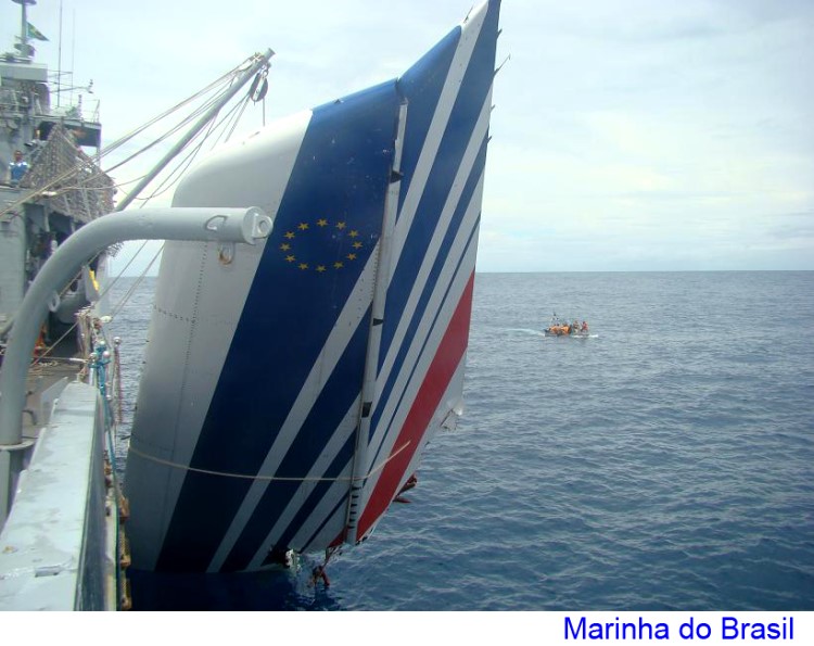
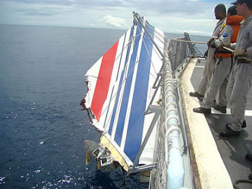
The BEA's description of the rudder was for the "in air" condition, but the "in water" condition was modified by the application of Archimedes' principle. As I have stated previously the V/S found itself in the water floating portside down, and flooding in the lower sections of the fin caused the line through the rudder hinge joints to sink deeper, especially at its base. This sinking condition was overcome by the bouyancy of the rudder, and the rudder moved to its maximum physical position of 35� to starboard. The overall effect was that the trailing edge of the rudder was level with the sea surface and around 2 meters above it. This condition is clearly evident in the low resolution screenshot taken from the BBC2 documentary where the fortuitous sun angle provides suitable shadow, and is reproduced below.

Another couple of screenshots from the BBC2 documentary reproduced below, may help with visualizing the manner in which the V/S was floating.


So, mon ami, the fin/rudder combination floated, had a breached buoyancy condition which provided a form of keel, and the rudder provided the surface area for the wind to interact with.
Apologies for the delayed posting. A family members house moving venture delayed proceedings.
Last edited by mm43; 21st April 2011 at 20:30.
Joined: Sep 2009
Posts: 5
Likes: 0
From: London, UK
I heard from someone close to inquiry that BEA have located the wrekage that should contain the recorders, and have also located the main passenger compartments, but main fusleage is broken into a few pieces. Pictures of this have been witheld for obvious reasons. So the recorders should be in Paris soon.
Joined: Aug 2009
Posts: 1,777
Likes: 0
From: Germany
Hi,
I wonder why they don't use a compensating system (hydraulic-air) like used on the drill rigs (semi) or DS for the risers tensionners and on the derrick travelling block
The Remora robot can work as far down as 6,000 meters. To ensure steady operation, a team of nine Phoenix experts will operate the 900-kilogram sub from the ship using large video monitors to track its progress. Every movement of the vessel at the surface is translated to the Remora's umbilical cable with a delay, said Brennan Phillips, manager of ROV operations at the University of Rhode Island in the U.S.
Delayed Reaction
"If the ship moves, it takes half an hour for the vehicle to feel it," he said. "You need an extremely stable ship."
Delayed Reaction
"If the ship moves, it takes half an hour for the vehicle to feel it," he said. "You need an extremely stable ship."

Joined: Mar 2003
Aviation Qualifications: ATPL
Posts: 2,558
Likes: 155
From: BC
Originally Posted by bearfoil @ 21st Apr 2011 09:40
As JAL shows, I think they remained relatively in control, but meandered in heading until they impacted the mountain. My point is that a fairly level arrival is possible w/o the Fin.
The only example we have to go by which speaks to loss of the VS before impact is the AA587 accident, which crashed immediately. The separation of the engines from the airframe was due to high lateral loads, due to the loss of the vertical stabilizer.
Joined: Jun 2009
Posts: 660
Likes: 0
From: I am where I am and that's all where I am.
MurphyWasRight, "There may be confusion here between time stamps,synchronous sampling and lower than nyquist sample rate artifacts," is right on the mark. Our good friend Nyquist is what syseng68k was forgetting about. The tick marks for left and right elevator are at different
times. You MAY be able to put the two streams together and derive what the elevator was really doing at the time. There will be some lag between their actuators. So some difference may be visible. Calibration tolerances may lead to further differences.
In this case if you simply draw the line through both sets of points you get a fairly decent picture of what the elevator as a whole was doing. And it's pretty clean about it.