


AF 447 Search to resume

Joined: Jul 2009
Posts: 1,682
Likes: 0
From: France - mostly
Originally Posted by Chris Scott
As HN39 indicates, the true "coffin corner" is where the 1g-buffet speed equals MMO.
The apex where the two lines intersect—where the minimum and maximum safe speeds are the same—is known euphemistically as “coffin corner”.
Regards,
HN39

Joined: Jul 2009
Posts: 1,682
Likes: 0
From: France - mostly
It is where the infamous "coffin corner" is. It isn't theoretical, but to get there you need more thrust than the A330 has installed.
EDIT:: The point is that the "coffin corner" is very far from where AF447 was.
Regards,
HN39
EDIT:: The point is that the "coffin corner" is very far from where AF447 was.
Regards,
HN39
Last edited by HazelNuts39; 27th March 2011 at 20:52.

Joined: Jul 2009
Posts: 1,682
Likes: 0
From: France - mostly
Thanks MM43;
In the example the available load factor at FL350 is 1.75 g. For 1.0 g, find the altitude where the ambient pressure is equal to that at FL350 divided by 1.75.
Regards,
HN39
In the example the available load factor at FL350 is 1.75 g. For 1.0 g, find the altitude where the ambient pressure is equal to that at FL350 divided by 1.75.
Regards,
HN39
Last edited by HazelNuts39; 27th March 2011 at 21:09. Reason: rewording for clarification

Joined: Jan 2008
Posts: 2,173
Likes: 51
From: Blighty (Nth. Downs)
Quote from HN39, post #2842:
Sorry Chris, I didn't say that, and it's not correct.
Apologies for the misinterpretation, HN39, and I stand corrected. I have edited my post #2839 by footnote.
I fully concur that, at FL350, AF447 was not cruising anywhere near "coffin corner". But the tropopause remains of interest, as always, for the reason I stated. Is there a difference of opinion on its altitude in the case of AF447?
Chris

Joined: Mar 2003
Aviation Qualifications: ATPL
Posts: 2,558
Likes: 155
From: BC
Hello Chris;
Just some comments on the trop; - the A330 rides the transition quite well even though, as you say, the ride can be rough.
I would say that temperature variations aren't wide enough to cause concern in terms of being too warm.
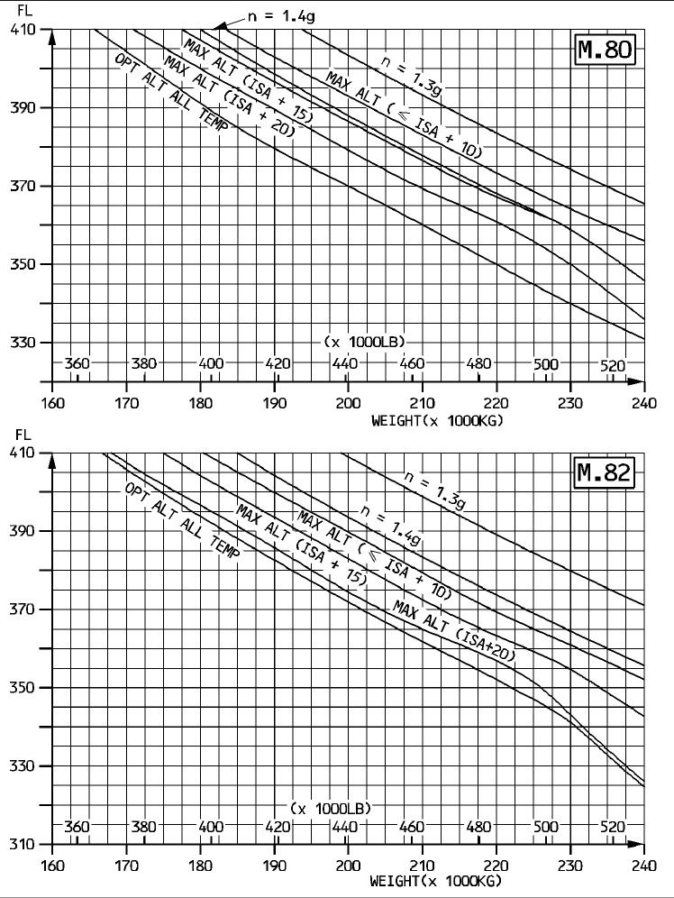
The optimum altitude and maximum altitude charts for M0.80 and M0.82 are below.
ISA+20 would not be a problem at FL350, 205T; the charts are for a cg of 37.0% but I believe a cg of 39.5% would not significantly affect operation in ISA+20 conditions.
The 'n' curve, (1.4g & 1.3g) indicate buffet margin. There are no bleed corrections for optimum altitudes but max operating alts for ISA+20 are reduced by: Engine Anti-ice only, 800'; Airframe and Engine A/I, 1900'.
None of this, by itself is a big thing. This is the stuff of normal cruise, and the airplane is a long way from the boundaries by planning and good flight management.
In reference to the reduced altitudes if antice protection is 'on', by "reduced" I am thinking that the airplane would probably stay at altitude if established there already but descent may be required if it warms up.
In other words, this kind of reduction doesn't meant the airplane is anywhere near "coffin corner" but astute crews may descend for slighly lower fuel flows.
Speed would not be a problem in most cases but if it warms up, a very slow bleeding off may occur - nothing dramatic that any crew wouldn't be able to plan for and determine a course of action.
Though the caveat is always "anything's possible", we have to bear in mind that ISA+20 is rare, higher even more rare, and they would have known about this variation from the flight plan.
Fuel load, cruise altitude selections, loading and routes would have been taken into consideration - it's standard work.
PJ2
Just some comments on the trop; - the A330 rides the transition quite well even though, as you say, the ride can be rough.
I would say that temperature variations aren't wide enough to cause concern in terms of being too warm.
The optimum altitude and maximum altitude charts for M0.80 and M0.82 are below.
ISA+20 would not be a problem at FL350, 205T; the charts are for a cg of 37.0% but I believe a cg of 39.5% would not significantly affect operation in ISA+20 conditions.
The 'n' curve, (1.4g & 1.3g) indicate buffet margin. There are no bleed corrections for optimum altitudes but max operating alts for ISA+20 are reduced by: Engine Anti-ice only, 800'; Airframe and Engine A/I, 1900'.
None of this, by itself is a big thing. This is the stuff of normal cruise, and the airplane is a long way from the boundaries by planning and good flight management.
In reference to the reduced altitudes if antice protection is 'on', by "reduced" I am thinking that the airplane would probably stay at altitude if established there already but descent may be required if it warms up.
In other words, this kind of reduction doesn't meant the airplane is anywhere near "coffin corner" but astute crews may descend for slighly lower fuel flows.
Speed would not be a problem in most cases but if it warms up, a very slow bleeding off may occur - nothing dramatic that any crew wouldn't be able to plan for and determine a course of action.
Though the caveat is always "anything's possible", we have to bear in mind that ISA+20 is rare, higher even more rare, and they would have known about this variation from the flight plan.
Fuel load, cruise altitude selections, loading and routes would have been taken into consideration - it's standard work.
PJ2
Joined: Jan 2008
Posts: 2,173
Likes: 51
From: Blighty (Nth. Downs)
Hi PJ2,
Your two cruise-performance charts neatly complement mm43's graph of Mach/FL/CG/Wt/Load Factor – thanks to you both.
PJ2's charts confirm that, because of its thrust limitations, the A330-200 with CF6-80E1A3 engines is unlikely to be climbed to a cruise altitude where the available load factor is much below 1.4g. Optimum Alt tends to give something of the order of 1.5g, and Max Alt gives just over 1.4g at M0.82.
(I think this is fairly typical of current turbofan airliners with their very high bypass-ratios, although twins like the A330 tend to have a higher available thrust-to-weight ratio than 3-engined and 4-engine types. So – unlike some aeroplanes with low-bypass-ratio engines, such as the VC10 – cruise altitude is limited by thrust rather than by the wing.)
Quote from PJ2:
Just some comments on the trop; - the A330 rides the transition quite well even though, as you say, the ride can be rough.
I would say that temperature variations aren't wide enough to cause concern in terms of being too warm.
Having ridden the trop routinely for 30 years, and flown this route, I agree; and am not suggesting for a moment that a trop encounter could have been the prime reason for AF447's demise. If severe icing turns out to be the primary, it is unlikely to be associated with the trop; most likely to be found in storm cells well below it. That's why I'm curious to know where the trop was. mm43 has mentioned a figure close to FL360, only 1000ft above AF447; HN39 has quoted an estimate of 15295m (about FL500).
There is, however, one very remote possibility that I would like to dismiss. At a frontal line, the trop layer typically steps up or down abruptly and considerably. (There may also be more than one layer.) If it is a step-down, the aircraft could transit in less than a minute from severe icing below the trop to an encounter with it. If that transition happened to coincide with the PF trying to fly the aeroplane using the technique for flight with unreliable speed indications (thrust/attitude), the effects would add seriously to his workload and any confusion.
Chris
Joined: Jun 2009
Posts: 1,330
Likes: 0
From: NNW of Antipodes
Tim Vasquez's weathergraphics.com page contains a lot of information relevant to this discussion. His profile graphic - reproduced below, with modified position timings gives a fairly good representation as to the likely condition of the air-mass.

You'll note that he is using ISA+10°C giving -44°C at FL350. Interpolation / extrapolation of OAT within the mesoscale system is a big variable. Tim quotes tops at 56,000 feet (17,000m), but doesn't see anything out of the ordinary in this ITCZ event. Lightning is also very rare within these marine environment MCS clusters, and none was recorded.
This event is most likely causal to the upset, but the why and how need answers.
Joined: Mar 2003
Aviation Qualifications: ATPL
Posts: 2,558
Likes: 155
From: BC
mm43;
Thank you for providing Tim's profile-view - I had seen it at some point but had lost track of it.
This will be repetitive as others who fly will have made similar observations, but...I am trying hard to come to terms with the flight path shown in Tim's schematic, and the two TCu's through which this path goes.
Even as this schematic cannot provide information on lateral deviation, I find it very difficult to accept that any crew would take such a path if not clear, even by accident, so good is this aircraft's radar. Further, I've done this many times over many decades, and so it is difficult to accept having no options but to fly into a canyon of TCu's, around which there was no safe options for passage. This of course means nothing except that it is difficult to accept, but possible, but then that possibility begs further, more interesting questions.
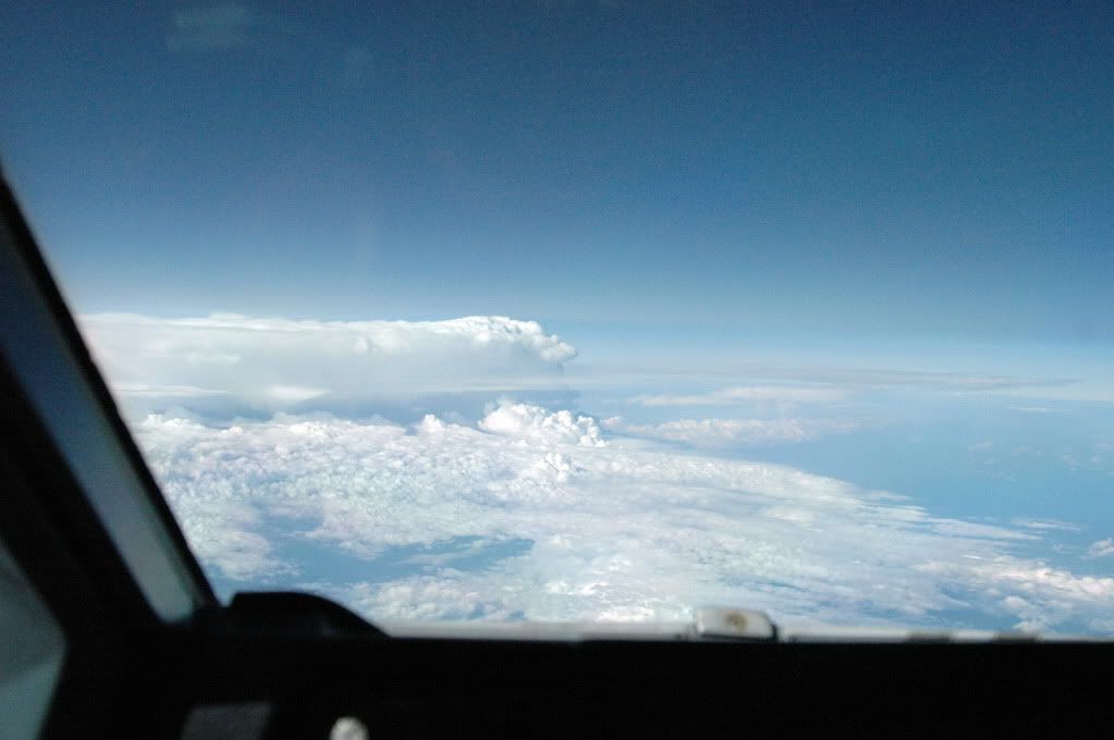
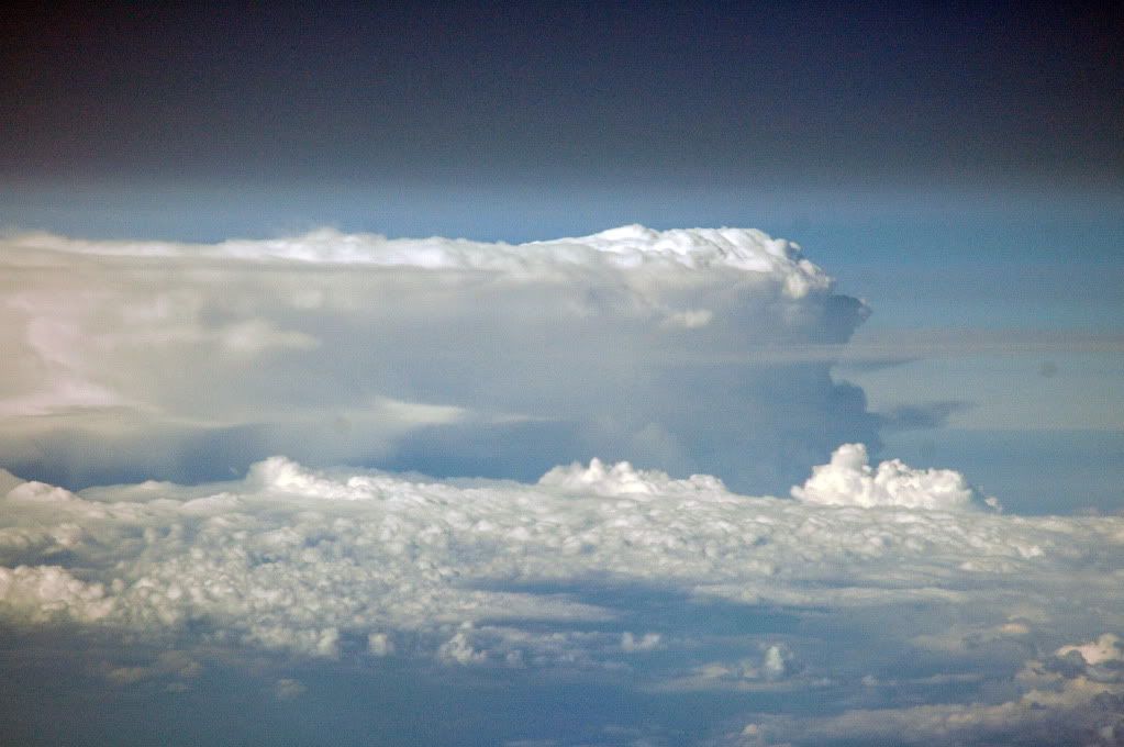
Perhaps it may help to view the following series of images which I photographed, abeam Brisbane, on a trip from HNL to SYD in December, 2006. This is in an A340. As per Tim's work, we know that the following example is not as complicated as the system AF447 faced, but using radar, paths can be found and we know this from having the luxury of examining the satellite photographs.
The potential for violent weather along the aircraft's path, as drawn, especially in the last two darker-gray areas of the last TCu could create extremely demanding circumstances for crew and aircraft alike, even without an unreliable airspeed abnormality.
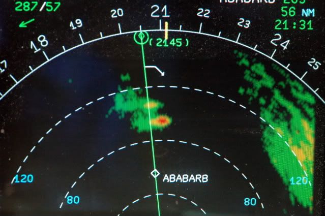
1. The first image shows the radar returns on the ND 160nm scale. The "ABABARB" is an abeam-waypoint which the FMGEC had inserted earlier when we were cleared direct to a down-route wpt. The top-right-hand display indicates an ETA for ABABARB of 21:31Z and a distance-to-go of 56nm. The white arrow pointing down just before the diamond symbol (2145) is the FMGEC-calculated start-of-descent point. The return to the far right is the Brisbane/Queensland coastal region of Australia.
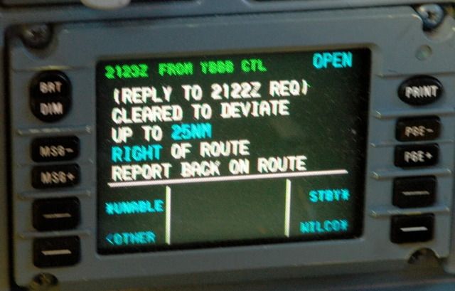
2. CPDLC displayed message from Brisbane, in response to the request to deviate to the right of course. The clearance was requested at 2122Z (in the white font) and the return message from ATC was delivered/received at 2123Z (top left corner)
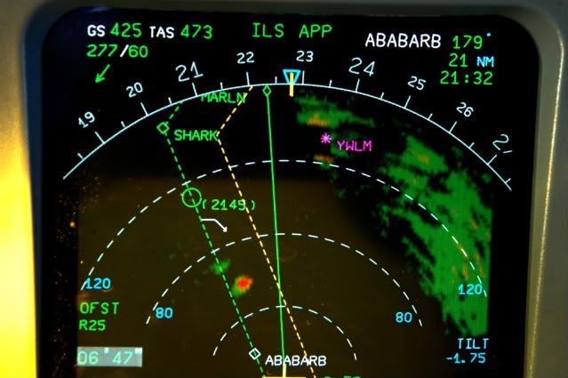
3. This is what a course deviation looks like done on the autopilot using the FMGEC "Offset" capability. The green line is the flight plan route. The amber line is the FMGEC inserted offset to the right. Turning right to intercept the offset can be done using Heading mode, or it can be done on the autopilot while in the normal LNAV mode. Note the distance travelled since the first photograph was taken...about 35nm. The distance travelled towards something to be avoided is a function of communications capability. Sometimes during poor HF conditions, especially on the North Atlantic, no request, or no response/clearance might occur and one may have to request that another aircraft relay the communications. Deviating without a clearance is rare, but under the captain's authority s/he can take whatever measures are necessary for safe flight. CPDLC is essentially a "Squawk Ident" while in mid-Atlantic or mid-Pacific and so is a huge advancement in safety. The radar antenna tilt is Down 1.75deg. The beam width of the A340/A330's antenna is 2.84deg so using the 1:60 rule, one can calculate heights above and below the returns. On the lower left of the ND, is "OFST R25" for the programmed offset of 25nm. To time the deviation, the chronometer has been started, also on the lower left, and reads 6' 47".
The blue triangle at the top is the heading selection. Blue indicates that the HDG mode and not the LNAV mode is engaged, (the triangle would be magenta for LNAV).
The wind is 277T/60kts, and one can see both from the radar image and the actual photographs, that the anvil is moving to the left.
Photographs 4 & 5 are of the actual thunderstorm being painted on the radar. The tops are well above our altitude, (which was probably FL390). From the radar picture just above, it doesn't appear threatening but the photographs show otherwise.
Thank you for providing Tim's profile-view - I had seen it at some point but had lost track of it.
This will be repetitive as others who fly will have made similar observations, but...I am trying hard to come to terms with the flight path shown in Tim's schematic, and the two TCu's through which this path goes.
Even as this schematic cannot provide information on lateral deviation, I find it very difficult to accept that any crew would take such a path if not clear, even by accident, so good is this aircraft's radar. Further, I've done this many times over many decades, and so it is difficult to accept having no options but to fly into a canyon of TCu's, around which there was no safe options for passage. This of course means nothing except that it is difficult to accept, but possible, but then that possibility begs further, more interesting questions.
Perhaps it may help to view the following series of images which I photographed, abeam Brisbane, on a trip from HNL to SYD in December, 2006. This is in an A340. As per Tim's work, we know that the following example is not as complicated as the system AF447 faced, but using radar, paths can be found and we know this from having the luxury of examining the satellite photographs.
The potential for violent weather along the aircraft's path, as drawn, especially in the last two darker-gray areas of the last TCu could create extremely demanding circumstances for crew and aircraft alike, even without an unreliable airspeed abnormality.
1. The first image shows the radar returns on the ND 160nm scale. The "ABABARB" is an abeam-waypoint which the FMGEC had inserted earlier when we were cleared direct to a down-route wpt. The top-right-hand display indicates an ETA for ABABARB of 21:31Z and a distance-to-go of 56nm. The white arrow pointing down just before the diamond symbol (2145) is the FMGEC-calculated start-of-descent point. The return to the far right is the Brisbane/Queensland coastal region of Australia.
2. CPDLC displayed message from Brisbane, in response to the request to deviate to the right of course. The clearance was requested at 2122Z (in the white font) and the return message from ATC was delivered/received at 2123Z (top left corner)
3. This is what a course deviation looks like done on the autopilot using the FMGEC "Offset" capability. The green line is the flight plan route. The amber line is the FMGEC inserted offset to the right. Turning right to intercept the offset can be done using Heading mode, or it can be done on the autopilot while in the normal LNAV mode. Note the distance travelled since the first photograph was taken...about 35nm. The distance travelled towards something to be avoided is a function of communications capability. Sometimes during poor HF conditions, especially on the North Atlantic, no request, or no response/clearance might occur and one may have to request that another aircraft relay the communications. Deviating without a clearance is rare, but under the captain's authority s/he can take whatever measures are necessary for safe flight. CPDLC is essentially a "Squawk Ident" while in mid-Atlantic or mid-Pacific and so is a huge advancement in safety. The radar antenna tilt is Down 1.75deg. The beam width of the A340/A330's antenna is 2.84deg so using the 1:60 rule, one can calculate heights above and below the returns. On the lower left of the ND, is "OFST R25" for the programmed offset of 25nm. To time the deviation, the chronometer has been started, also on the lower left, and reads 6' 47".
The blue triangle at the top is the heading selection. Blue indicates that the HDG mode and not the LNAV mode is engaged, (the triangle would be magenta for LNAV).
The wind is 277T/60kts, and one can see both from the radar image and the actual photographs, that the anvil is moving to the left.
Photographs 4 & 5 are of the actual thunderstorm being painted on the radar. The tops are well above our altitude, (which was probably FL390). From the radar picture just above, it doesn't appear threatening but the photographs show otherwise.
Last edited by PJ2; 29th March 2011 at 00:20. Reason: grammar, additional comments
Joined: Jan 2008
Posts: 2,173
Likes: 51
From: Blighty (Nth. Downs)
Thanks, mm43,
I've got a few queries on Tim Vasquez's nice profile-graphic.
(1) The isotherms are all perfectly straight, horizontal lines, which seems simplistic.
(2) The tropopause is not shown, although there are a couple of clues in:
(a) the northerly anvil-top at about 45000ft amsl/-69C, and
(b) the average lapse rate between -70C and -75C of only 1C/1000ft.
(3) The altitude axis is annotated "MSL", and the aircraft is shown tracking at 35000ft. It would be interesting to calculate the disparity between that and FL350, i.e., 35000ft pressure altitude, and plot a line for FL350.
The word "tropopause" appears about three times in his piece, but only in the context of cloud-top overshoot; he does not discuss the lapse rate characteristics, or its altitude within or to the north edge of the bigger Cb - which may well represent the ITCZ frontal face. North of that build-up, the isotherms remain perfectly horizontal.
Chris
PS: Those great pictures take me back, PJ2...
Last edited by Chris Scott; 29th March 2011 at 09:31. Reason: (3) added. Clarifications.
Joined: Jul 2009
Posts: 1,682
Likes: 0
From: France - mostly
Thanks, MM43 and PJ2 for your most elucidating inputs.
Chris;
Figure 11 of Tim Vasquez' analysis shows the temperature profile of the atmosphere up to the tropopause and beyond, up to FL 700, and the temperature inside the CB. The temperature profile is obtained from a balloon ascent from Fernando de Noronha. I thought this provides some good background to some of your questions/remarks.
Regards,
HN39
Joined: Jan 2008
Posts: 2,173
Likes: 51
From: Blighty (Nth. Downs)
Hello HN39,
Yes, the tephigrams on Figs 10 & 11 would be interesting. I've ignored them so far because, even using browser zoom magnification, I'm unable to read the blurred scale numbering - let alone the other information.
[EDIT] Eureka: have belatedly noticed the enlargement facility he kindly provided!
Chris
Last edited by Chris Scott; 29th March 2011 at 12:41.
Joined: May 2010
Posts: 22
Likes: 0
From: Le Shed on the Tropic of Capricorn
mm43. You are supposed to be keeping us informed yet it is 6 days since you last posted Alucia's position. When you get a chance, can you give us an update on the current position of the Alucia and if she is heading towards or away from the 'pollution spot' vicinity (ie getting warmer or colder). Maybe you could edit your #2830 post to include the Alucia's current position. It would be greatly appreciated.
thanks in anticipation.
FF
When you get a chance, can you give us an update on the current position of the Alucia and if she is heading towards or away from the 'pollution spot' vicinity (ie getting warmer or colder). Maybe you could edit your #2830 post to include the Alucia's current position. It would be greatly appreciated.thanks in anticipation.
FF

Joined: Jan 2008
Posts: 2,173
Likes: 51
From: Blighty (Nth. Downs)
Hi FluidFlow and Lyndon Johnson,
Welcome. As mm43 is antipodal (and presumably asleep) I will interject to say I have it on good authority that he (and broadreach) are doing their absolute best, as always. As soon as a position or other news becomes available, rest assured they will post it...
Chris
Welcome. As mm43 is antipodal (and presumably asleep) I will interject to say I have it on good authority that he (and broadreach) are doing their absolute best, as always. As soon as a position or other news becomes available, rest assured they will post it...
Chris
Joined: May 2010
Posts: 126
Likes: 0
From: MA, USA
There is a new article on USA Today. While not presenting any new information, it does summarize the situation well and clearly discusses the rational and methods of the Phase 4 search.
Robots enlisted in Round 4 of search for Flight 447 wreckage - USATODAY.com
Robots enlisted in Round 4 of search for Flight 447 wreckage - USATODAY.com
Joined: Jul 2010
Posts: 624
Likes: 0
From: East sussex
I'm curious as to (USAToday link) if they located the aircraft.
1) Would the robots be capable of cutting through fuselage to extract the flight recorders?
2) Would the robots be capable of lifting large a/c parts to the surface?
I read (above link) the previous search found a large oil drum, might be pushing it to find an object of a large biscuit tin size.
Curious.
Daz