


Air Niugini Aircraft crash, Truk Lagoon

FlightGlobal also say it is an undershoot:-
https://www.flightglobal.com/news/ar...ndersh-452267/
https://www.flightglobal.com/news/ar...ndersh-452267/

USN UCT Team
Impressed that they would enter the fuselage of the aircraft. Brave move. The video looks like the hull (its floating) is completely survivable, I hope that suggests the airline just has a manifest count problem rather than a lost pax. Strange things happen, but this looks like it should have been survivable for all on board.

I was curious about the �cloud break procedure�. Which sounds like (If I may be frank) bull****e, masked as technique.
As the above extract from the approach plate shows, the 3 degree profile brings the aircraft to the MDA (420 feet) at the MAP, which is 2.2 nautical miles from the threshold. Simple maths tells us that a 3 degree profile should have the aircraft at 700 feet when 2.2 nm from the threshold. As per the dashed lines (circled on the plan form view) there is then a visual segment (provided the aircraft is visual) of almost 1 mile to intercept the 3 degree profile at about 1.3 nm from the threshold.
It is unfortunate that the profile view of the procedure suggests that the descent from the MDA to the touchdown zone is coincident with the 3 degree path. It is not. If the aircraft descended on a 3 degree path from the MAP, it would very likely land short.
I'll let the NTSB do the investigating, but just point out that such procedures are not uncommon in this part of the world.
Join Date: May 2011
Location: Up north
Age: 35
Posts: 43
Likes: 0
Received 0 Likes
on
0 Posts
Wet and short runway with variable winds, so presumabely crew knows there is not much extra runway, and wants to touchdown maybe slightly earlier than usually. PAPIs U/S or not, water refraction creates the illusion of being high, resulting in a more shallow glidepath. Any other lights than PAPIs will strenghten the illusion even further.
Edit: Seeing the plate above, those REILs would appear to be much closer than they actually are in moderate rain.
Edit: Seeing the plate above, those REILs would appear to be much closer than they actually are in moderate rain.
Last edited by Pirrex; 29th Sep 2018 at 10:20. Reason: REIL
Huh, I don't see any such suggestion in the way the diagram is drawn...seems blatantly obvious that 3 degrees gets you from the FAF to the MAPt and nowhere else (as you correctly point out).
If you flew 3 degrees from the FAF at 1700 feet, you will not get to the 420 ft MDA before the MAP. You would reach HAMAX (MAP) at 745 ft.
If you want to increase your chances of getting visual, you have to go below the 3 degree profile to get to 420ft and fly level to the MAP or continue visually.
Hence the mention of a �cloud break� procedure. Not ideal, but it�s there.
If you want to increase your chances of getting visual, you have to go below the 3 degree profile to get to 420ft and fly level to the MAP or continue visually.
Hence the mention of a �cloud break� procedure. Not ideal, but it�s there.

I find CW's point entirely reasonable. On first glance at the chart, it would indeed appear that an extrapolated 3 degree path beyond MAP would lead to the runway, but this is misleading as the scale for the 5 & 3nm segments is changed drastically for the final 2.2 nm......
Cloud break procedure is a valid instrument arrival to a visual manoeuvre, just check Mt. Hagen PNG and surrounding terrain, we used the cloud break back in the late 80,s. That procedure was a let down AWAY from the runway with the visual manoeuvre back.
The preference is generally for a constant descent angle approach without intermediate level offs and no driving along at the minima. Possibly the spot height at the right of the red circle necessitates having the MAP further back then normal which would require a low level segment to reach the runway.
This would require a careful briefing of the relatively non standard approach procedure. In this case I believe it would be safer to have a CDA approach to the threshold and accept the higher minima that this would entail.
This would require a careful briefing of the relatively non standard approach procedure. In this case I believe it would be safer to have a CDA approach to the threshold and accept the higher minima that this would entail.
Join Date: Jul 2007
Location: Hadlow
Age: 60
Posts: 597
Likes: 0
Received 0 Likes
on
0 Posts
It is neither BS nor technique.
As the above extract from the approach plate shows, the 3 degree profile brings the aircraft to the MDA (420 feet) at the MAP, which is 2.2 nautical miles from the threshold. Simple maths tells us that a 3 degree profile should have the aircraft at 700 feet when 2.2 nm from the threshold. As per the dashed lines (circled on the plan form view) there is then a visual segment (provided the aircraft is visual) of almost 1 mile to intercept the 3 degree profile at about 1.3 nm from the threshold.
It is unfortunate that the profile view of the procedure suggests that the descent from the MDA to the touchdown zone is coincident with the 3 degree path. It is not. If the aircraft descended on a 3 degree path from the MAP, it would very likely land short.
I'll let the NTSB do the investigating, but just point out that such procedures are not uncommon in this part of the world.
AFAIK the report on the last accident in the FSM (a runway overrun at PTPN by an Asia Pacific AL B722 freighter in 2008) is still awaited, so don't hold your breath.
Join Date: Jan 2008
Location: Federal Way,WA,USA
Age: 89
Posts: 1
Likes: 0
Received 0 Likes
on
0 Posts
Technically this is a CRASH....................Ditching procedures advise: Gear Up and Outvalve(s) closed plus the engines should usually detach !
Yes, 737 fwd doors will be above water level when ditching .
Well done Boeing!
Retired Boeing Engineer
Yes, 737 fwd doors will be above water level when ditching .
Well done Boeing!
Retired Boeing Engineer
It is neither BS nor technique.
As the above extract from the approach plate shows, the 3 degree profile brings the aircraft to the MDA (420 feet) at the MAP, which is 2.2 nautical miles from the threshold. Simple maths tells us that a 3 degree profile should have the aircraft at 700 feet when 2.2 nm from the threshold. As per the dashed lines (circled on the plan form view) there is then a visual segment (provided the aircraft is visual) of almost 1 mile to intercept the 3 degree profile at about 1.3 nm from the threshold.
It is unfortunate that the profile view of the procedure suggests that the descent from the MDA to the touchdown zone is coincident with the 3 degree path. It is not. If the aircraft descended on a 3 degree path from the MAP, it would very likely land short.
I'll let the NTSB do the investigating, but just point out that such procedures are not uncommon in this part of the world.
Regarding �Cloud Break procedure� - The point I was making was this; There is no such thing in ICAO (gone) AIP, AIM or any other Instrument Approach manual or regulation. Africa and Papua are the only places that I�m aware of it remaining on approach charts. If it�s in Air Niugini manuals then I bow to your superior knowledge. What you�re describing to me is the visual segment post MDA/DDA/DA. ie. the portion of an Instrument approach where the aircraft is maneuvering to landing. It may have a level segment, it may even be a curved one (RNAV RNP 01).
Terminology
- If this RNAV GPS approach is flown to an MDA of 420 in LNAV/VNAV the missed approach is conducted at 420ft, If the runway isn�t in sight. If it is, continue and land. If a portion is flown level to intercept the (missing) PAPI or visual path then so be it.
- If flown in VS (dive and drive, or continuous descent) then in is flown to a MAP.
There is no MAP in an RNAV GPS flown in LNAV/VNAV. It�s an MDA that triggers the missed approach or Visual segment. How long have Air Niugini been doing RNAV RNP Approaches in the 73NG ?
Addendum:
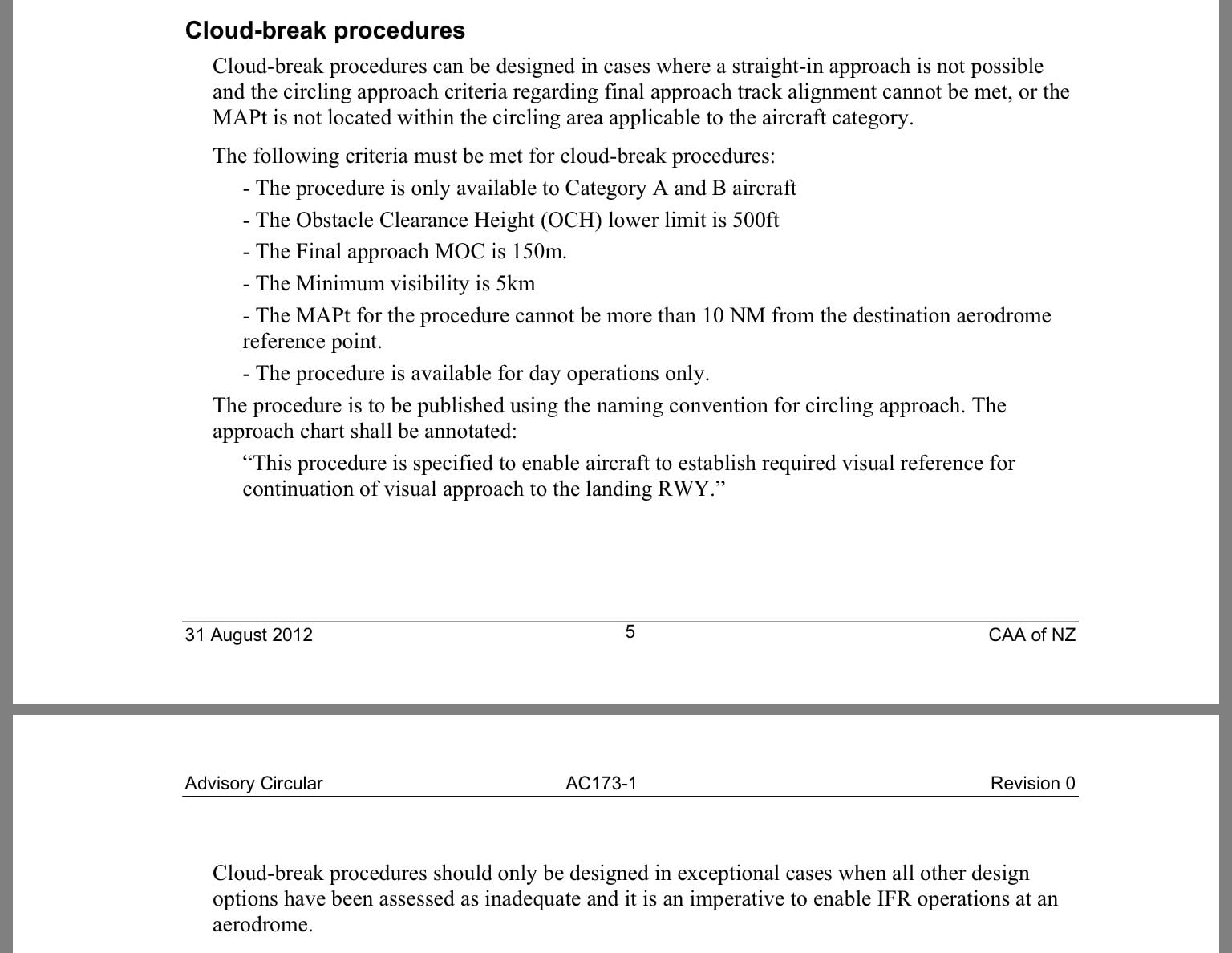
For what it�s worth; the only Cloud Break Procedure reference that I could find was an old NZ Advisory Circular (2012). It doesn�t appear relevant to a 737-800 on an IAP for a number of reasons. �Category� would be one.
Cheers.
For what it�s worth; the only Cloud Break Procedure reference that I could find was an old NZ Advisory Circular (2012). It doesn�t appear relevant to a 737-800 on an IAP for a number of reasons. �Category� would be one.
Cheers.
IMHO and not necessarily related, I always felt dive and drive appropriate for situations where the visibility was good, base above the MDA, and especially when doing non-straight-in approach. Anytime on a straight in approach in limited visibility a CDA approach is preferable.

