


So WestJet almost puts one of their 737 in the water while landing at St-Maarten...

Was there a Windshear event? Microburst event?
Wait for the FDR and official report

Join Date: Mar 2007
Location: Ottawa, Ontario
Age: 66
Posts: 21
Likes: 0
Received 0 Likes
on
0 Posts
Yesterday, here in YYC where West Jet is based, the local media aired the video of the infamous approach. West Jet finally acknowledged that the approach was in fact too low. They claimed that due to rapidly changing weather conditions on the approach, the crew defended below the glide path but quickly corrected and executed a missed approach as they are so thoroughly trained to do! Of course they downplayed the entire event, and suggested that the event will further enhance safety at WJ as the event will be reviewed and shared amongst crews. I'm assuming that this will be done through their SMS, but herein lies the disparity. Realizing that an airline has to maintain a positive public image, they chose to ignore the event or downplay its seriousness. The premise of an SMS is full disclosure. Come clean with what occurred, identify the weaknesses, develop changes to procedures so it won't re occur and share the process. ( at least that's how TC here in Canada wants the system to work). When the company denies the significance of an occurrence does it not promote a culture within to not embrace SMS. Here in Canada, that means back to fulll regulatory enforcement, and disciplinary action against the airline, crews and management.
Join Date: May 2005
Location: Ontario, Canada
Posts: 163
Likes: 0
Received 0 Likes
on
0 Posts
It seems like a bigger deal is being made of this than needed. They were low, yes, but it seems like a matter of getting visual with the runway then either gusting winds/windshear or illusions / misjudgement due to the weather. But the key thing is that they realized their mistake, admitted it, and went around as they should have.
No one is free from making mistakes, the key is to recognize and react. Seems like they did that here.
About the descending below MDA, they likely did so and did so correctly: being visual with the runway and continuing as normal. We have a clear view of the aircraft in the photos and videos from various vantage points. While there was some weather and rain, the pilots must have been visual with the runway and lights.
Join Date: May 2009
Location: Home
Posts: 63
Likes: 0
Received 0 Likes
on
0 Posts
VDP distance in St.Maarten
Some interesting points about the VOR approach into SXM.
If descending to an MDA of 770 feet the VDP distance is 2.2 DME.
If descending to an MDA of 500 feet the VDP distance is 1.5 DME.
So if WestJet was descending to 770 feet, the prevailing visiblity might not have enabled the runway to be visible.
Clearly though, the aircraft was below 770 feet on the go-around.
Probably descended below MDA, broke out below the 3 degree path, and executed a go-around.
[IMG]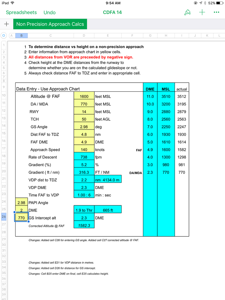 [/IMG]
[IMG]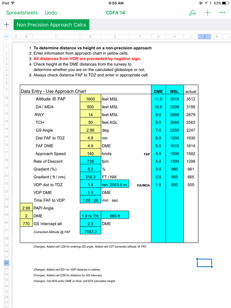 [/IMG]
If descending to an MDA of 770 feet the VDP distance is 2.2 DME.
If descending to an MDA of 500 feet the VDP distance is 1.5 DME.
So if WestJet was descending to 770 feet, the prevailing visiblity might not have enabled the runway to be visible.
Clearly though, the aircraft was below 770 feet on the go-around.
Probably descended below MDA, broke out below the 3 degree path, and executed a go-around.
[IMG]
 [/IMG]
[IMG]
 [/IMG]
Join Date: Jun 2001
Location: Rockytop, Tennessee, USA
Posts: 5,898
Likes: 0
Received 1 Like
on
1 Post
Those low transition levels (FL 65 in this case) are spring loaded to mess up. I've sure made the mistake myself but had the luxury of catching it on an ILS crossing altitude.
Also, on a non-precision approach, even if a nice path is depicted in the FMS, it doesn't guarantee that path will continue to the touchdown zone in my experience. Years ago the LOC Rwy 27 at SAN (San Diego, California for that feller who couldn't figure out how to Google 'prosumer'
 ) had a nice path in the box to the runway threshold but since the actual touchdown zone was displaced, you had to add power and level off momentarily to get on the PAPI's for the rest of the descent.
That data isn't affected by whether or not the crew set the correct QNH on the altimeter subscale.
Join Date: Jun 2001
Location: Rockytop, Tennessee, USA
Posts: 5,898
Likes: 0
Received 1 Like
on
1 Post
See: http://www.pprune.org/9706787-post99.html
It's easy to get busy down low and miss the transition level, especially when it's below FL100 dodging weather in the Caribbean. And, with the accents, 1019 might certainly be heard as 1009.
A misset altimeter is definitely one of the things that can ruin your whole day on a non-precision approach down to minimums.
Another thing that can get you on the NP approach is a bad setup in the FMS giving you a path that is not the right one. Still, it shouldn't get you below minimums without the runway in sight if you do the call outs and adhere to stable approach criteria.
Christine Negroni has a picture of the UPS BHM A300 crash in her article linked on the first post on this thread. In that mishap, the crew had an incorrect FMC setup with a bogus path that was above them. For some reason, the captain V/S'ed them into the ground with 1500 feet per minute down at 1000 AGL, which should have been an automatic go around.
Join Date: Jun 2000
Location: last time I looked I was still here.
Posts: 4,507
Likes: 0
Received 0 Likes
on
0 Posts
What I find odd is that there are no DME/ALT checks after 1600' at 4.8nm. EFIS a/c do LNAV/VNAV descents to MDA. (the chart shown in #17 is not an RNAV approach. Is there one?) However, older, perhaps more private a/c are steam driven. This would invite, especially over the obstacle free sea, a Dive & Drive profile. Either way, the crew procedures should be a level off at 500' or 770' until 2nm and a decision if the runway is in sight yes/no. Then a land or GA decision.
I have to admit, if was in my (dream on) private twin prop on a murky day with a hot date waiting, I might be tempted to shave a bit off (if you get my drift) and nibble below the belt to see if I could get in. However, I would not like a crowd to join me, so I think in a B738 case I'd be respecting my master and his rules.
I have to admit, if was in my (dream on) private twin prop on a murky day with a hot date waiting, I might be tempted to shave a bit off (if you get my drift) and nibble below the belt to see if I could get in. However, I would not like a crowd to join me, so I think in a B738 case I'd be respecting my master and his rules.
Join Date: Sep 2013
Location: UK
Posts: 730
Likes: 0
Received 0 Likes
on
0 Posts
Rat, the "M" is the missed app point. It's not a great name for it. It's not the point at which you should commence a missed app; that should happen at the minima on the glide path. It is the earliest point that lateral navigation should switch from the approach path to the missed app path, preventing early turns on intercept headings and not relevant (and hence rarely shown) where the missed app tracks a radial or is flown straight ahead.
The minimums callout, automatic or from PNF, would, on a non-precision app or Cat 1 ILS be baro alt related, so again, incorrectly high subscale settings would create an excessively low callout. More evidence that this could be the cause, but, again, far from conclusive.
The 737NG does not have GPS related altimetry, though the side profile view on the NAV display on aircraft with this customer option will show a GPS derived profile to a database display of terrain and airfield elevation. While there is no warning generated, a close look at that profile wile show a mismatch between baro and GPS profile by having the runway floating above or buried under the terrain, depending on which direction the altimeter setting error occurs. The rad alt displays from 2500' on the PFD. Custome spec may have a number of automatic callouts. Any crosscheck against the baro alt while over the sea should have revealed misset altimeters if that was the case.
It's probably worth clarifying what we can deduce (based on the transponder data) to have been the minimum height to which the aircraft descended on its first approach (at approximately 1.1 nm from the threshold):
Baro height: 100' (to nearest 25')
Actual height AMSL: 250' (approx - based on baro height, adjusted for METAR QNH)
Altimeter indicated height: we don't know (but likely to have been close to one of the two above values unless a completely spurious subscale setting was used)
Join Date: Jun 2001
Location: Rockytop, Tennessee, USA
Posts: 5,898
Likes: 0
Received 1 Like
on
1 Post
http://www.pprune.org/9702902-post48.html
What makes me think that WestJet shot the VOR Z is that the missed approach on the WS 2562 ADS-B track looks more like the 180 degree course of the published miss on the VOR approach rather than the direct ONBED missed approach on the RNAV plate. Also, with weather at minimums, MDA is 500 feet on the VOR approach, 700 feet for the RNAV.
Of course, the tower may have given them turn right heading 180, maintain 4000 feet after the RNAV approach.
Join Date: Jan 2006
Location: US
Posts: 2,205
Likes: 0
Received 0 Likes
on
0 Posts
A lot of altimeter discussion. VDP is approx 486'/1.6 nm. The picture is at approx 50' and .3-.5 nm. An altimeter setting has nothing to do with getting that low while in visual conditions.
Allegedly report of wind shear which is why there was a delay before subsequent approaches were attempted.
Allegedly report of wind shear which is why there was a delay before subsequent approaches were attempted.
Join Date: Oct 2010
Location: 5° above the Equator, 75° left of Greenwich
Posts: 411
Likes: 0
Received 0 Likes
on
0 Posts
For all this talk about wrong altimeter setting...it's a sea level airport. The pressure differential (between std and actual) is not that high, and the altitude error resulting from a missed (with a D not a T) altimeter setting is way less than the altitude at which they ended up at.
Some other fellow posters have commented about some sort of distraction after breaking out at minima. This seems the explanation that satisfies me the most. Murky weather, breaking out at or near minima, both pilots looking out for the runway, PM forgetting to monitor instruments, altitude vs horizon difficult to assess due to weather plus it being a beach/sea airport certainly doesn't help with the optical illusions.
For the sake of the argument, yes they did what they're supposed to, i.e. go around, but I certainly would like to know how they ended up in such scenario, so we all (or me at least!) can avoid or at least identify such scenario before getting to such little error margins...
Oh and btw, to me at least, the microburst/windshear scenario doesn't quite work with me, given what I've seen both on video and also the metar I saw from one of the articles I've seen regarding this hmm, occurrence.
Regards, your Caribbean/Latin American jet pilot
and the altitude error resulting from a missed (with a D not a T) altimeter setting

Maybe someone can set up a approach to landing rating website.
Enjoy the link, pretty cool.
Maho Beach Cam - SXM Airport Cam on St Maarten
Enjoy the link, pretty cool.
Maho Beach Cam - SXM Airport Cam on St Maarten
Join Date: Jun 2000
Location: last time I looked I was still here.
Posts: 4,507
Likes: 0
Received 0 Likes
on
0 Posts
For the sake of the argument, yes they did what they're supposed to, i.e. go around,
Given that, I presume, they had 500' set in Baro and that there would have been GPWS call out at +100 & minimums, I wonder what caused them to make a GA so low? If they went below MDA, that's one thing. An altimeter mis-setting might be 150'; that still leaves them 350' above the waves, but as someone said the error would likely put them high. So what instigated the GA? Some guys say they did what they should have, correctly; therefore there is no case to answer. Hm? They should have done it much earlier!
So what else happened? They sure as heck didn't bust out at minimums, see the water so close and think this was not a good idea and then GA. Something happened between the Baro call out of "minimums" and the decision to GA. From the photo that seemed to be quite a longtime. Meanwhile the RA was reading very low. How do WJ fly an NPA? Was PM looking for the runway and PF inside? Were they flying manually and both pilots looking outside wth no-one 'managing the office'? Were they in V/S & automatics with both pilots looking outside?
In most of my Ops PF looks inside & PM looks outside nearing minimums. At minimums if PM does not see the visual reference and call visual PF makes a GA: never looks outside. No hesitation. Both pilots scratching around at minima, both looking outside, no-one managing the office, manual flight or V/S, going pass "minimums not visual" recipe for...............
Join Date: Sep 2013
Location: UK
Posts: 730
Likes: 0
Received 0 Likes
on
0 Posts
Escape path, altimeter error is not limited to forgetting to set QNH on transition. They could have been passed/misheard an incorrect QNH and set 1029 instead of 1019, for example. I've had that happen a handful of times, and was fortunate to remember the pressure in the weather brief or have got a Volmet or ATIS that said something different, catching the mistake. Perhaps this crew didn't have the same luxury of a cross check. It fits with why they went below real altitude minima heads-in, why the ADSB shows no major deviation, and fits with the most common cause for such incidents. It's all circumstantial, but don't shoot the idea down without evidence to the contrary.