


A Sukhoi superjet 100 is missing

Join Date: May 2012
Location: USA
Posts: 4
Likes: 0
Received 0 Likes
on
0 Posts
There is one and only one question in this case. Why would any pilot request clearance to below the known peak altitudes of stratocone volcanoes in conditions in which those peaks cannot be seen?

Join Date: Sep 2011
Location: Indonesia
Posts: 8
Likes: 0
Received 0 Likes
on
0 Posts
There is one and only one question in this case. Why would any pilot request clearance to below the known peak altitudes of stratocone volcanoes in conditions in which those peaks cannot be seen?
Join Date: Sep 2007
Location: The 'Bat Cave' @ HLP in the Big Durian Indo
Age: 61
Posts: 781
Likes: 0
Received 0 Likes
on
0 Posts
Now they say they haven't found FDR
Reports on retrieved Superjet 100 flight-data recorder denied: Voice of Russia
I don't understand the confusion , have they or haven't they found the FDR ?
This isn't the only article to rebuke yesterday's announcement that they found the FDR , there's also a few on the Indonesian language press.
Even this story seems to contradict itself
Reports on retrieved Superjet 100 flight-data recorder denied
Tags: News, World, Russia, Sukhoi Superjet-100 , plane crash , Society
May 13, 2012 10:30 Moscow Time
Photo: EPA
The head of the Indonesian national search and rescue agency, Madya Daryatmo denied earlier reports that Superjet 100 flight-data recorder was found.
Earlier Gagah Prakoso, spokesman for Indonesia's national search and rescue agency told reporters that the investigators from the National Transportation Safety Committee (KNKT) had retrieved the flight-data recorder of the Russian-made Sukhoi Superjet 100 that crashed in Indonesia on May 9.
At present the evacuation of the bodies of the victims is continuing and the rescuers are searching for the black-boxes of the crashed airliner.
By now Russian rescuers have joined rescue operations at Superjet 100 crash site in Indonesia.
Russia's Sukhoi Superjet-100 black box found
The investigators from the National Transportation Safety Committee (KNKT) have retrieved the flight-data recorder of the Russian-made Sukhoi Superjet 100 that crashed in Indonesia, Gagah Prakoso, spokesman for Indonesia's national search and rescue agency told reporters in Jakarta Sunday.
About 70 Russian rescuers have joined the work on the search of the second black box and evacuation of the bodies of the victims.
Russia�s Superjet-100 crashed on May 9 during a demonstrational flight. There were 45 people on board.
Rescue operations at Superjet-100 crash's site resumed in Indonesia
Rescue operations in Indonesia at the site of Russia�s Superjet 100 airliner�s have resumed.
Late Saturday, the first group of 29 rescuers of Russia�s Emergency Ministry flew to the coordination center not far from the city of Bogor. The second group of 25 rescuers is on the way to Bogor.
Two helicopters delivered from Moscow have flown to the area of the air crash.
Russia�s Superjet-100 crashed on May 9 during a demonstrational flight. There were 45 people on board.
RIA
This isn't the only article to rebuke yesterday's announcement that they found the FDR , there's also a few on the Indonesian language press.
Even this story seems to contradict itself
Last edited by aseanaero; 14th May 2012 at 13:41.
Join Date: May 2012
Location: USA
Posts: 4
Likes: 0
Received 0 Likes
on
0 Posts
Yes. The request could have been for sight-seeing or for the descent/approach to Halim, 32nm north. The two possibilities that roughly fit with the available photographs & videos are the flight paths into the west-southwest canyon or the north-northeast canyon.
The contents of the flight data recorder is almost certainly going to be embarrassing for both the Indonesian authorities and Sukoi. Given how things often get done in that part of the world I would not be surprised if those in charge of the investigation make sure it never turns up........
Join Date: Oct 2002
Location: In my seat
Posts: 822
Likes: 0
Received 0 Likes
on
0 Posts
Big Pistons,
What a load of Bull!
The Russian CAA and Accident Investigation Bureau is as a matter of fact very professional and always publishes extremely thorough and honest reports. Get your facts right please.
What a load of Bull!
The Russian CAA and Accident Investigation Bureau is as a matter of fact very professional and always publishes extremely thorough and honest reports. Get your facts right please.
Join Date: May 2010
Location: -
Posts: 66
Likes: 0
Received 0 Likes
on
0 Posts
Given how things often get done in that part of the world I would not be surprised if those in charge of the investigation make sure it never turns up........
 . How can anyone with even a passing knowledge of all the Indonisian incidents and accidents in recent years make such a silly statement
 Last edited by Big Pistons Forever; 14th May 2012 at 16:52.
Join Date: May 2010
Location: -
Posts: 66
Likes: 0
Received 0 Likes
on
0 Posts
How can anyone with even a passing knowledge of all the Indonisian incidents and accidents in recent years makes a silly statement

Last edited by ap08; 14th May 2012 at 16:20.
Seriously off topic, but:
On a different thread we had a rather fruitful debate on the Canadian policy of not releasing CVR transcripts, even AAIRs contain only edited excerpts. Some of us were on the opinion that this policy seriously hampers full understanding of events leading up to an accident, which should be the fullest priority of any investigaton...
Seriously you are comparing Canada's Civil Air transportation regulatory regime in general and the Canadian Transportation Safety Board in particular, to the goat rope that is Indonesian avaition regulation .
.
Last edited by andrasz; 14th May 2012 at 17:55.
Re �� new safety device/procedure/regulation tends to instil more confidence, and perhaps complacency.� #298 barit1,
In general I would agree.
From a limited flight evaluation of T2CAS (several years ago), the uniqueness of the predictive climb capability stood out as something which could be misused. Just because a computation predicts that the aircraft can out-climb the rising terrain (alt/distance) does not mean that the aircraft will avoid terrain if the required procedures are not followed, and of course there are still rare situations where the aircraft performance is insufficient.
A significant difference between EGPWS and T2CAS is that the simplistic originating ideas (an alerting function �Terrain Ahead� � the crew should take action, and the warning function �Terrain Pull Up� � the crew must take action) have been intermixed with what-if �conditional� computations in T2CAS which perhaps encourage deliberation in the choice of action as opposed to immediate action.
Whatever the crew thought in the accident situation may not be known.
My conclusions from flying T2CAS towards steeply rising terrain (too steep) may have been biased by the VFR conditions and ability to turn sharply to avoid the terrain as the limits of the warning mode (aircraft performance) were reached, but I didn�t �buy� the system at that time.

Join Date: Aug 2008
Location: Vancouver
Age: 77
Posts: 6
Likes: 0
Received 0 Likes
on
0 Posts
Seriously you are comparing Canada's Civil Air transportation regulatory regime in general and the Canadian Transportation Safety Board in particular, to the goat rope that is Indonesian avaition regulation .
.
Psychophysiological entity
So often in these tragedies one can see some reason - some possible logic in the crew's thinking, but this one has me beat. If indeed they were flying south-ish in the valley, they would have been heading towards the highest point towering a thousand feet above the requested. That peak is just a 'stone's throw' from the crash site.
Is it conceivable that for a moment each pilot was comfortable with the rising ground on their side - thinking they were simply to the side of a solid mass?
Having done the Innsbruck run for some years, I know only too well how a wide open space suddenly becomes a claustrophobic gully when one pilot turns the wrong way.
Join Date: Aug 2011
Location: Los Angeles
Age: 65
Posts: 8
Likes: 0
Received 0 Likes
on
0 Posts
The Sukhoi SJ100 has T2CAS fitted, which allegedly offers greater protection to CFIT.
A good point was made earlier about regional data feeds to the EGPWS. Common and commercial sense suggests a Demo aircraft would have all its tricks on show to potential purchasers.
So, why did the T2CAS not alert the Test Pilots to the impending ridge?
A good point was made earlier about regional data feeds to the EGPWS. Common and commercial sense suggests a Demo aircraft would have all its tricks on show to potential purchasers.
So, why did the T2CAS not alert the Test Pilots to the impending ridge?
It is possible, that the replacement Sukhoi SJ100 EGPWS was not uploaded with regional data?
Loose rivets;
On the German aviation forum cited earlier, there is a Google Earth image suggesting a flight path around Mt. Salak beginning south of the mountain then circling the mountain to the right, and, perhaps in the belief that the "wide open space" to their right was the south end of the mountain again, the aircraft was turned to the right, and up the canyon.
This assumes that views of some sections of the mountain were partially obscured and that either the aircraft was in cloud most of the way up the canyon or the TAWS was, for whatever reason(s), not functioning as intended.
...but this one has me beat. If indeed they were flying south-ish in the valley, they would have been heading towards the highest point towering a thousand feet above the requested. That peak is just a 'stone's throw' from the crash site.
Is it conceivable that for a moment each pilot was comfortable with the rising ground on their side - thinking they were simply to the side of a solid mass?
Having done the Innsbruck run for some years, I know only too well how a wide open space suddenly becomes a claustrophobic gully when one pilot turns the wrong way.
This assumes that views of some sections of the mountain were partially obscured and that either the aircraft was in cloud most of the way up the canyon or the TAWS was, for whatever reason(s), not functioning as intended.
Join Date: May 2012
Location: .de
Posts: 3
Likes: 0
Received 0 Likes
on
0 Posts
Hello everyone,
I am long-term reader, first time poster to PPRuNe.org.
I have followed this thread since the morning after the incident had happened. After some bits 'n' pieces out of a thread I have contributed to in the german community @ flugzeugforum.de had been quoted here yesterday, I decided to sign up here, in order to share the findings we have elaborated there so far.
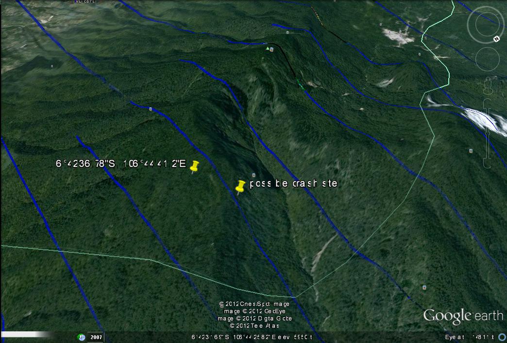
1. Crash site coordinates:
On May 11th, hand-written coordinates on a sticky note from the situation room have been spread on the internet.
As some of you have already pinpointed, these coordinates don't fit to what is supposed to be the crash site, if you look them up in Google Earth.
The reason for that may be different geodetic datums, as the SAR troops there may be using military topo maps, that do not necessarily use WGS84 as reference datum. Therefore, an offset of coordinates compared to Google Earth and/or other maps may exist.
By comparison of photographs and videos from the crash location to the ground profile in GE, we came to the same conclusion as PJ2 pointed out some posts ago. The point of impact is supposed to be located at 6�42'46.08"S 106�44'7.38"E in Google Earth.
2. Assumed flight path to point of impact:
Based on the first coordinates published on avherald.com on the afternoon of May 10th (6.7045S 106.7373E), as well as further details that became public the same day (descent from 10k to 6k cleared by ATC; coordinates of loss of radar contact; circle round Mt. Salak in clockwise direction), I worked out what I believe to be the route flown by the crew until impact.
As new crash site coordinates from the situation room were published the day after (May 11th), that theory no longer appeared to be valid. But as we found out in the meantime, with the actual crash site now discovered in GE (because coordinates published from the situation room seem to be of a different datum, see above), that theory became valid again (even more than before...).
Here it is, in a nutshell:

Viewing direction in the image above is roughly 200� (SSW). Marked in yellow, the two summits of Mt. Salak and the ridge connecting them.
The plane enters the image from top left corner (descent 10k -> 6k MSL). Then, it performs a clockwise circle round Mt. Salak.
Towards the end, the path is split in three:
Red continuous: assumed flight path to point of impact, based on crash coordinates published on May 10th (following the ground profile along the right-hand slope and thereby accidentially entering the "canyon" that was formed when the formerly cone-shaped caldera sled down).
Red dashed: What I think was the originally planned flight path round the mountain.
Purple: updated flight path to point of impact as of May 13th (based on further research and comparison of pictures and video to Google Earth. Heading at point of impact ~ 210�).
I am long-term reader, first time poster to PPRuNe.org.
I have followed this thread since the morning after the incident had happened. After some bits 'n' pieces out of a thread I have contributed to in the german community @ flugzeugforum.de had been quoted here yesterday, I decided to sign up here, in order to share the findings we have elaborated there so far.
1. Crash site coordinates:
On May 11th, hand-written coordinates on a sticky note from the situation room have been spread on the internet.
As some of you have already pinpointed, these coordinates don't fit to what is supposed to be the crash site, if you look them up in Google Earth.
The reason for that may be different geodetic datums, as the SAR troops there may be using military topo maps, that do not necessarily use WGS84 as reference datum. Therefore, an offset of coordinates compared to Google Earth and/or other maps may exist.
By comparison of photographs and videos from the crash location to the ground profile in GE, we came to the same conclusion as PJ2 pointed out some posts ago. The point of impact is supposed to be located at 6�42'46.08"S 106�44'7.38"E in Google Earth.
2. Assumed flight path to point of impact:
Based on the first coordinates published on avherald.com on the afternoon of May 10th (6.7045S 106.7373E), as well as further details that became public the same day (descent from 10k to 6k cleared by ATC; coordinates of loss of radar contact; circle round Mt. Salak in clockwise direction), I worked out what I believe to be the route flown by the crew until impact.
As new crash site coordinates from the situation room were published the day after (May 11th), that theory no longer appeared to be valid. But as we found out in the meantime, with the actual crash site now discovered in GE (because coordinates published from the situation room seem to be of a different datum, see above), that theory became valid again (even more than before...).
Here it is, in a nutshell:
Viewing direction in the image above is roughly 200� (SSW). Marked in yellow, the two summits of Mt. Salak and the ridge connecting them.
The plane enters the image from top left corner (descent 10k -> 6k MSL). Then, it performs a clockwise circle round Mt. Salak.
Towards the end, the path is split in three:
Red continuous: assumed flight path to point of impact, based on crash coordinates published on May 10th (following the ground profile along the right-hand slope and thereby accidentially entering the "canyon" that was formed when the formerly cone-shaped caldera sled down).
Red dashed: What I think was the originally planned flight path round the mountain.
Purple: updated flight path to point of impact as of May 13th (based on further research and comparison of pictures and video to Google Earth. Heading at point of impact ~ 210�).
Last edited by mcgyvr81; 15th May 2012 at 02:23.
Join Date: Jan 2008
Location: Sydney
Posts: 102
Likes: 0
Received 0 Likes
on
0 Posts
I'm following this story with interest, I feel for the poor souls on board that lost their lives in this accident. Old swiss-cheese sequence of events no doubt but hopefully they can find out and prevent it happening again.
Soviet cheese seems to have many more holes in it.
Soviet cheese seems to have many more holes in it.
mcgyvr81;
Welcome to PPRuNe. I was kindly helped by others to see what was on your forum. It was your work to which I was referring in my post just above, so I'm glad you presented your graphic here, which I thought was a reasonable theory and very well presented. Thank you for signing up and contributing.
Hopefully when the recorders are read, the Indonesian authorities will provide a summary of what the data shows.
Join Date: May 2012
Location: USA
Posts: 4
Likes: 0
Received 0 Likes
on
0 Posts
mcgyvr81
I read several Indonesian news that the nearest side of ground rescue command center is in Cijeruk which is located east part of Mt Salak, you can check the location in Google map. I still believe that crash site is on east part of ridge and it would not make sense for ground rescuers to reach west ridge by crossing the canyon.
By comparison of photographs and videos from the crash location to the ground profile in GE, we came to the same conclusion as PJ2 pointed out some posts ago. The point of impact is supposed to be located at 6�42'46.08"S 106�44'7.38"E in Google Earth.
Thank you mcgyvr81. A good initial starting point for a year or two of discussion, as with the AF447 thread.
Thanks, PJ, and am glad you jumped in.
As far as the ground proximity warning systems go, I am not that confident they can predict a future flight path when in a turn and only assume that you are flying straight ahead. So in a turn the system may not be "looking" to the "inside of the turn". Our military terrain following systems looked straight ahead for the most part. Our "cross-scan" mode showed terrain above you as well as provided the vertical guidance according to your settings and such for the terrain following. So we had an advantage that the commercial airliners don't have, to the best of my knowledge. We also had the vertical guidance that showed "need a pull up in a few seconds" or, "pull up now" you dummy.
This is a sad incident, and I feel very badly for all involved, and especially for the folks that were enjoying a neat demo flight.
I'll return to the lurk mode now.

