


Melbourne Coastal Route / YMML Runway 34 GBAS

This has to be the largest and most significant screw up by ASA & CASA for many years!
CASA are meant to be about and promote safety, then why was this change (the levels) not consulted with ALL interested parties including the Vic RAPAC? Where is the safety case/risk analysis?
The change can continue with all the attend risks, but it could also be deferred with perhaps much less risk, but that would upset the airlines who pay the bills and have much more influence than GA.
Looks like the Iron Ring are still there and flexing their ego like they still trying to do on the MULTICOM.....
Time for the Director to kick some but!... and take charge

Someone asked the question at the CASA Flight Instructor Safety Workshop yesterday but I didn't notice any sign that they wanted to answer the question nor discuss it at all.
I agree this change hasn't been thought out or managed well, but to correct some misconceptions:
CASA, not Airservices.
Airservices's responsibility would have been limited to proposing the airspace change and publishing the charts and DAP. They aren't responsible for VFR notes and procedures in Class G airspace including NOTAMs related to such. That's CASA's bailiwick.
Not sure what you are referring to here - the ML VTC online from Airservices includes the expanded portion down the bottom of the chart, and always has.
The VNC shouldn't be used for operations within the terminal area, which is why they have the usual box around the area and note saying "USE VTC" for operations within, with the VTC showing far greater detail. It would be like trying to use an ERC within a terminal area instead of a TAC.
CASA now have a problem.
Deferring use of the charts presents a safety issue, in that some pilots will use them and may or may not be aware of the deferment.
Therefore the safety issue ASSW with deferring the charts has to be balanced with the safety issue ASSW the VFR route changes .....
This has to be the largest and most significant screw up by ASA & CASA for many years!
Airservices's responsibility would have been limited to proposing the airspace change and publishing the charts and DAP. They aren't responsible for VFR notes and procedures in Class G airspace including NOTAMs related to such. That's CASA's bailiwick.
If I were flying visually in the terminal area only, my first reaction is to get the VTC. In which case, AsA in its wisdom denies me the information about the changed recommended VFR route cruising levels.
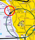
The VNC does not have the notations / recommended directions, or at least for Melbourne it doesn�t.
The "direction change" was NOT part of any of the briefings. it is a late change implemented by CASA without any consultation with RAPAC or the OAR. It is believed that the only consultation may have been with the airlines.
CASA were supposed to have had an education programme, but with now less than 2 weeks until implementation there is no sign of any communication programme whatsover from CASA.
RAPAC has called on CASA to defer the change. CASA has rejected this.
CASA were supposed to have had an education programme, but with now less than 2 weeks until implementation there is no sign of any communication programme whatsover from CASA.
RAPAC has called on CASA to defer the change. CASA has rejected this.
Deferring use of the charts presents a safety issue, in that some pilots will use them and may or may not be aware of the deferment.
Therefore the safety issue ASSW with deferring the charts has to be balanced with the safety issue ASSW the VFR route changes .....
Join Date: Mar 2018
Location: Currently: A landlocked country with high terrain, otherwise Melbourne, Australia + Washington D.C.
Posts: 396
Likes: 0
Received 0 Likes
on
0 Posts
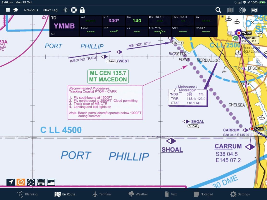
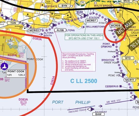
Perhaps leaving east-/southbound unchanged at 1500 ft and west-/northbound at 2500 ft outside and down to 2000 ft inside the zone would be an easier way to accommodate this new LL.
not sure what you are referring to here - the ML VTC online from Airservices includes the expanded portion down the bottom of the chart, and always has.]
The on-line AsA might be useful in the air conditioned ivory towers in which CASA lives, but it’s hardly an inflight reference.
Even as an old school pilot that first learned to fly in 1973, I now fly with 2 x iPads. It’s all you need to be legal and It’s what I would suggest most pilots are doing. Airservices in its wisdom does not supply this as part of the electronic VTC that it makes available to AvPlan & Ozrunways.
Avplan ( and I believe Ozrunways) supply the detail of the Moorabbin enlargement in the VNC and in the “mega WAC” products, but not the VTC. And Their licence agreement with AsA forbids then from modifying it in any way.
As primarily an IFR pilot and as someone trained before the advent of VNC charts, I reach for the VTC for visual navigation around the Melbourne basin - and it does not contain any detail on the cruising altitudes for the VFR route.
If on NOV 9, Others like me who use the VTC on their iPad will have no clue that CASA has changed the direction of flight of the VFR route that they may well have been accustomed to since the mid seventies when the VFR route was introduced.
And CASA has no education / communication plan for the change.
CASA has created the antecedents of a mid air collision.
Join Date: Mar 2018
Location: Currently: A landlocked country with high terrain, otherwise Melbourne, Australia + Washington D.C.
Posts: 396
Likes: 0
Received 0 Likes
on
0 Posts
In 1968 Sweden changed from driving on the left to driving on the right literally overnight. This was a major move to adapt to the majority of cars that had wheels on the left which caused a high number of collisions when passing cars with little clearance. Surprisingly, statistics following the change showed that car accidents instantaneously dropped. Six months later, accidents rates climbed back to their original numbers.
CM: OA is referring to the VTCs available in EFBs.
There�s a weird and counter-intuitive aspect of selecting just the VTC as the chart instead of the �mega� composite map that �stitches� all the WACs, VNCs and VTCs together.
If you select just the VTC, you can�t �zoom in� to see the large scale insets that provide more detail. However, if you select the �mega� map, it does incorporate the insets.
For example, when I select the current Sydney VTC on the EFB I use, there is no depiction of the vertical dimensions of the YSBK airspace, no matter how far I zoom in. However, if I select the �mega� chart, it does depict �D 1500/SFC� inside the YSBK CTR boundary. I have been caught out by this precise difference.
The lack of education campaign about the Melbourne changes is, sadly, a manifestation of a �safety� authority that has long since been that in name only.

Avplan ( and I believe Ozrunways) supply the detail of the Moorabbin enlargement in the VNC and in the �mega WAC� products
Last edited by Squawk7700; 27th Oct 2018 at 08:02.
In 1968 Sweden changed from driving on the left to driving on the right literally overnight.
In this instance, CASA decided on the change virtually overnight AFTER its consultation process and is not planning any EDUCATION or COMMUNICATION about the change.
For example, when I select the current Sydney VTC on the EFB I use, there is no depiction of the vertical dimensions of the YSBK airspace, no matter how far I zoom in. However, if I select the ‘mega’ chart, it does depict “D 1500/SFC” inside the YSBK CTR boundary. I have been caught out by this precise difference.
How could you be caught out? If a particular chart doesn't have what you want ie the CTR vertical dimensions, choose a chart that does.
Guys and Girls.
Can I just suggest you don�t get too bogged down in the details.
Just get out there and fly to the best of your ability, responsibly and safely.

Can I just suggest you don�t get too bogged down in the details.
Just get out there and fly to the best of your ability, responsibly and safely.
Join Date: Jun 2006
Location: Brisbane
Posts: 265
Likes: 0
Received 0 Likes
on
0 Posts
Except when the airlines don't need it for weather and still opt to use it because of fuel efficiencies, or because it is more precise than an RNAV.
If it is only going to be used on the days when the weather really warrants its use, why not leave the airspace as is, and then have a NOTAM for the 30 days a year. Similar to a Temp Restricted Airspace setup.
If it is only going to be used on the days when the weather really warrants its use, why not leave the airspace as is, and then have a NOTAM for the 30 days a year. Similar to a Temp Restricted Airspace setup.
It is, however, a safer approach. From memory, in recent years, Singair have royally screwed up an RNAV onto 34, and VOZ screwed up a visual from over Essendon. There are threads about both these incidents on this forum - both 777�s I think, and both descended way below profile. I think the Singair was at 900 feet at 10NM so at least they were under the lane

I would imagine that most GLS profiles will follow exactly the same path as the RNAV. That is, a continuous descent via the STAR onto final. This would mean no change to current jet altitudes over the lane. However the GLS (unlike the RNAV) allows ATC discretion to vector onto the approach at a lower altitude. They may do this occasionally to optimise arrival rates, but I wouldn�t expect it to be the norm. So I wouldn�t be too worried about wake turbulence.
As to CASA�s poor form in communication, no argument there. They�ve known this was coming for a couple of years now.
How could you be caught out?
I’m just trying to help others understand the issue to hopefully reduce the possibility of others making the same mistake.
It must be very satisfying being perfect, Bloggs.
What "error"? What "mistake"? Anybody would think you busted CTA or something equally catastrophic. For someone who tears strips off me for wanting to radio jabber, you're carrying on a bit about nothing.
Nobody said you had to. The auto-zoom is a feature of the Hybrid VFR map, as you know. Have you contacted the app maker for an explanation? Perhaps they designed it so that you could either stay on the individual map you deliberately chose, or you could have auto-zoom on the Hybrid.
Swapping from an individual inset to an individual VTC then to a VNC and vice versa in a busy arrival or departure environment is unnecessarily distracting.
According to an ATSB Publication “Aviation Occurrence Statistics 2007 to 2016” (here: https://www.atsb.gov.au/media/577388...-104_final.pdf ) there were over the period covered by the publication this number of occurrences by type “airspace infringement”:
- 3 accidents and serious incidents in air transport operations
- 158 incidents in air transport operations
- 12 accidents and serious incidents in GA operations
- 386 incidents in GA operations
- 2 accidents and serious incidents in recreational aviation
- 21 incidents in recreational aviation
- 2 incidents involving RPAS.
The mistake I made to become one of those statistics was to look at the EFB VTC chart and assume that the lower level of the C over YSBK was 2,000’, which was the closest depiction of the Class C airspace lower level. If I’d used the ‘mega’ map instead I would not have made the same mistake, as it depicts D 1,500/SFC at the location of YSBK.
Not an excuse. Just an explanation for what happened.
Thankfully, few airspace infringements result in a catastrophe. In my case, YSBK tower queried whether I had clearance to climb into the C above at 1,500’ as I passed through that level. I said ‘no’ and immediately descended to 1,500’. Submitted a report ‘fessing up’.
I realise that you never could make a mistake that resulted in an airspace infringement, Bloggs, but lots of others can and do. It’s in your interests that those of us who are fallible highlight the kinds of circumstances in which mistakes happen. (I thought it was SOP for RAAF pilots to brief their colleagues on mistakes made, why the mistake was made and the consequential risks. Perhaps that enlightened approach was introduced after you pulled the pin?)
Which kinda loops back to the point OA was making about the potential for pilots to overlook the information depicting significant changes to tracking altitudes for aircraft around the standard lanes/tracks Melbourne, if they use just the VTC on an EFB. Not an excuse. But a potential explanation (along with the absence of appropriate education) for a mid air, don’t you think?
We know.
But what do you see if you open just the Melbourne VTC?
But what do you see if you open just the Melbourne VTC?
Thanks for that diatribe, LB.
It is a pity that, in your first post on the issue:
You didn't even mention the REAL problem: that the "C LL1500" label over BK doesn't exist on the Sydney VTC. That fact only came to light a couple of posts later after much nashing of teeth and claims that I am perfect.
I agree that you don't get that CTA LL of 1500 info unless you look at the inset. The VTC should have a C LL 1500 caption on it in the BK "CTR" freq boundary area. The LL 2000 close by is deceiving. But that is more of a chart deficiency than a poor feature of the app.
I suggest you hop onto your friendly local RAPAC to suggest a change to the Sydney VTC to add a C LL 1500 label. There's enough space for it and I'm sure it will be supported by the other RAPACs.
Anyway, I see that CASA has just issued a note to all RAPAC addressees regarding the Melbourne issue. Spread it around!
It is a pity that, in your first post on the issue:
For example, when I select the current Sydney VTC on the EFB I use, there is no depiction of the vertical dimensions of the YSBK airspace, no matter how far I zoom in. However, if I select the ‘mega’ chart, it does depict “D 1500/SFC” inside the YSBK CTR boundary. I have been caught out by this precise difference.
I agree that you don't get that CTA LL of 1500 info unless you look at the inset. The VTC should have a C LL 1500 caption on it in the BK "CTR" freq boundary area. The LL 2000 close by is deceiving. But that is more of a chart deficiency than a poor feature of the app.
I suggest you hop onto your friendly local RAPAC to suggest a change to the Sydney VTC to add a C LL 1500 label. There's enough space for it and I'm sure it will be supported by the other RAPACs.
Anyway, I see that CASA has just issued a note to all RAPAC addressees regarding the Melbourne issue. Spread it around!