


Norwegian media reporting RNoAF Hercules missing

Join Date: Sep 2003
Location: 59�45'36N 10�27'59E
Posts: 1,032
Likes: 0
Received 0 Likes
on
0 Posts
Press conference now.
Police says rescue operation suspended at 17:30 local time, partial human remains located in a avalance at the base of the mountain.
All five crew assumed dead.
Next of kin informed earlier.
RIP guys
Police says rescue operation suspended at 17:30 local time, partial human remains located in a avalance at the base of the mountain.
All five crew assumed dead.
Next of kin informed earlier.
RIP guys

Join Date: Jun 2009
Location: Norway
Age: 76
Posts: 43
Likes: 0
Received 0 Likes
on
0 Posts
Plane collided with mountain at full speed
According to the newly held press conference, operation has been downgraded from rescue to search, according to Norwegian news from two channels.
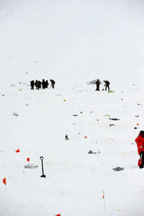
The plane flew straight into the western side of the mountain at full speed, exploded, and triggered an avalanche. Wreckage parts are found in the remains of the avalanche; most parts are the size of stationary. All traces are covered with newly fallen snow.
Some body parts have been found by mountain rescue dogs and will be tested for DNA.
Wreckage parts were also flung over onto the other side of the mountain.
There are constant avalanches in the area. The glaciers are full of crevasses.
Last edited by roaldp; 17th Mar 2012 at 19:39.

Even without severe wind conditions flying in Norway in winter can have its problems.
Back in the late seventies I was flying from Voss across the interior to an area that was in a valley with stacks of railways, roads and a town. It was a gin clear day with no wind so navigation was easy; point it in the right direction and after 45 minutes you will arrive.
I was sitting there; ThiB & MiN looking at a ridge ahead that was the nearside of the valley I was heading for. AllofaSudden the radalt 50' ft warning went off and the shadow of a snowdrift flashed past me. The scenery behind me then registered as a snow covered ridge. I had flown over it without even realising it was there.
I have heard stories, and I can believe them, of people sitting in an aircraft that has just come to a stop for no reason until they realise that they have flown into snowbank.
It is difficult flying in Norway, especialy during the winter and I am in full admiration for those that do it all the time. May they rest in peace.
Join Date: Apr 2009
Location: Hotel Gypsy
Posts: 2,821
Likes: 0
Received 0 Likes
on
0 Posts
Yes, featureless terrain can really bite. I recollect that Keith Collister succumbed to a similar effect with sand dunes in the immediate run-up to GW1 whilst low level in his Jaguar.
Very sad to hear today's news. As someone who was fortunate enough to head North of the Artcic Circle every February I always enjoyed the Scandinavian exercises. Without exception, excellent hosts.
Very sad to hear today's news. As someone who was fortunate enough to head North of the Artcic Circle every February I always enjoyed the Scandinavian exercises. Without exception, excellent hosts.
Ex K driver here and very sorry to hear this tragic news. RIP to those that are lost, so sad for those who are left to grieve.
Join Date: Feb 2002
Location: Greenland
Posts: 18
Likes: 0
Received 0 Likes
on
0 Posts
This is a terrible accident.
My thoughts goes to the crew`s families. Surely they all must suffer from their loss of a family member.
There are a lot of speculations through this tread. Its only natural, because we all want to know what happend.
In my mind, I would like to rise a few questions.
What where this aircraft doing there? They new where they where going. That mission was approved by a squadron leader. or their leading officer. They had been going through the route before the flight
Did they follow a low level route and became lost and choose the wrong wally?
A Jas Gripen pilot stated that he flew in the same area just after the C130 contact was lost, and he could see the mountain peaks was in the clouds. I know that the landscape can change totally when low clouds covers mountain tops and side wallys.
Could the crew of the C-130 have flown into a wally, thinking this was initially the right place, but in the last second to realize that they where not, and immediately executed a climb? Having realized that the only way out of this wally was to climb?
I would assume that an aircraft with so powerful engines and without any load, would be able to climb like an elevator? Did they initiate the climb too late?
Where there problems with the aircraft? Engine failures. of some sort perhaps, No radio com`s states that there might have been one.
Fact is that nearby people have heard a load bang at the time, when contact of Siw was lost.
Fact is they have hit the mountain peak at great speed, due to the spread of the wreckage, and parts, and the size of the wreckage parts as well.
Will they be able to locate the CVR, and FDR? Since no ELT was set off, was the impact so high, that everything was smashed to atoms?
The impact relased an avalange and the following storm have erased the tracks in wich angle the plane have hit the mountain side.
Unless they locate a fully working FDR and or CVR, we will never know for sure what really happen.
My deepest condolences goes the families, and may your loved ones rest in peace.
sincerly...

Join Date: Jun 2009
Location: Norway
Age: 76
Posts: 43
Likes: 0
Received 0 Likes
on
0 Posts
Autopilot off, tactical flying was permitted
Norwegian Broadcasting radio news this Sunday morning at 06:00 reports that the crew was flying with the autopilot off, and that there were no known technical malfunctions with the plane. The flight was on a routine mission from Evenes in Norway to Kiruna in Sweden to pick up personnel and cargo before returning, and was already on approach ("under innflyvning") to land at Kiruna. The usual flight path is well north of the mountains, where the actual altitude would be normal.
A Hercules following 10 minutes behind reported that they were allowed to "fly tactical" (manually) if weather permitted. Weather was changing fast, but was probably better before the accident than previously reported.
More details in the link below from Aftenposten.no, where Google Translate may replace "Evenes" with "Glasgow". All heights are originally stated in meters, not feet:
Google Oversetter
Original article in Norwegian here:
- Sannsynligvis fl�y de taktisk - Aftenposten
Nordic pilots are, of course, familiar with the whiteout-effect and other winter conditions. Moreover, the height of mountains is part of primary school teaching in both Norway and Sweden. Kebnekaise is well-known even to civilians.
The emergency transmitter HAS been found, but was not working and will be investigated. Search continues for the FDR and CVR with hopes that they have survived the impact.
Better weather forecast for this Sunday:
Hourly forecast for Kebnekaise Sydtopp, Norrbotten (Sweden)
Join Date: Nov 2011
Location: Somewhere close to me
Posts: 742
Likes: 0
Received 0 Likes
on
0 Posts
From Dagbladet /Norway:
"Oberstl�ytnant S�lna er imidlertid sikker p� at ulykken ikke skyldes teknisk feil p� flyet, som var n�ye sjekket p� forh�nd. "
Ulykkesflyet skulle bli angrepet av jagerfly - nyheter - Dagbladet.no
Translated it says:
"Colonel- Lieutenant S�lna is sure the accident was not due to a technical fault with the aircraft, as the aircraft was properly checked in advance"
Should not Mr S�lna leave these conclusions to the Accident Investigation Team? What an arrogant attitude, to come out with such a comment at this early stage!
Coming out now is that the aircraft was probably flying tactical, weather was good, expecting fighter planes to "attack" it, but they was 100 Km away from the Hercules, and Officer S�lna is sure certain there was NO technical issues with the aircraft!
What an easy job for AI than!
Join Date: Feb 2011
Location: Europe
Posts: 291
Likes: 0
Received 0 Likes
on
0 Posts
RIP
Even though it was highly unlikely, I was hoping till the end they would survive
I dont like speculating on that subject, but taking crew experience and that plain was new (tech. fault unlikely), I would assume something with wind shear, that plain was not able to overcome.
According to radars, they did loose a lot of altitude right before they disappeared and impact was high speed (not best glide speed). As well, weather did change a lot during that time (plane that flew 10min before them, reported perfect weather).
Anyhow, it is incredibly sad. It remind for all of us, that we must execute a lot of caution and be careful. My deepest condolences to family, friends and 335 squadron.
RIP
Join Date: Nov 2006
Location: Europe
Posts: 31
Likes: 0
Received 0 Likes
on
0 Posts
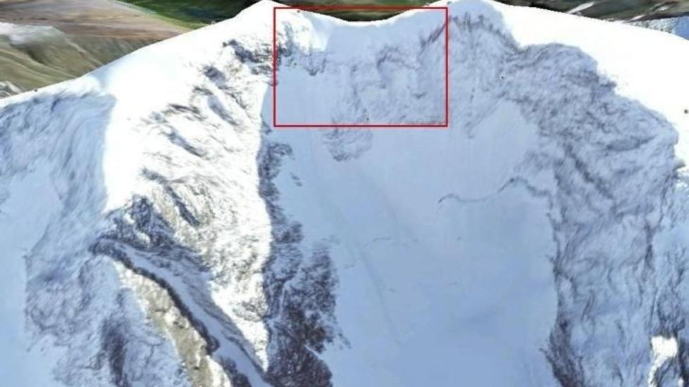
We now know they were flying tactical, VFR. The mounstainside where they impacted is covered in snow, combine that with changing weather and visibility... makes you think of whiteout. Furthermore, the mountainside is shaped like a semicircle. Having flown in there in the first place, it's like a trap...
Champagne anyone...?

Given the radar altitude returns, I don't think CFIT, whiteout and hidden ridges etc are to blame here. Assuming they are accurate (and if they're not then all bets are off), the radar returns show the aircraft in a gradual climb already established above the altitude of the top of the mountain. The weather wasn't necessarily good and indeed the Gripen pilot reported the mountain to be covered in cloud at the time of the loss and other contemporaneous reports suggest very strong winds & poor weather in the area. The rescuers couldn't reach the area for some time due to the weather.
I am still of the opinion (for what it's worth) that they either saw the deteriorating weather ahead so elected to pull out of low level and climb to MSA or were climbing to pick up a radar service for recovery into Kiruna. There was probably no intention of routing via any of the IFR STARs - I certainly wouldn't have been considering the STARs if looking for a radar pick up to vectors ILS or visual. Assuming the altitude and wind reports are correct I can only assume that they either encountered a very large down-draught, very sudden severe icing or very intense lateral shear from which recovery was not possible. There may well have been some technical failure that coincided with their cresting Sweden's biggest mountain but I'm not convinced. Only a structural failure, massive icing or the loss of thrust on three or more engines would bring the aircraft down to the altitude at which it struck the ridge.
As long time J pilot I'm very interested in the cause of (and saddened by) this loss. This sort of sortie profile is the "bread and butter" of a tactical transport aircraft like the C130J which, despite being the same size (and a bit heavier) than a 737, is operated in a totally different way to similar civilian aircraft. Discussions of autopilots and IFR arrivals are irrelevant. Many of us, this crew included, spend/spent much of our time operating down at around 100m AGL, in the valleys, around, under and through bad weather and are familiar with the all the risks and traps that can lead CFIT. Familiarity doesn't automatically grant one immunity but, based on the altitude returns, weather reports, crew experience and equipment fit on the J, I just don't believe CFIT, whiteout etc were factors here.
Rick Studder - radar showed them being nearly 1000ft above the impact point 2 miles before it. Even at 180kt turbulence speed the aircraft would of have to have entered a 1500-2000fpm descent to get to the impact point from it's last radar return. It would take something pretty serious to bring that on....
Join Date: Nov 2006
Location: Europe
Posts: 31
Likes: 0
Received 0 Likes
on
0 Posts
Rick Studder - radar showed them being nearly 1000ft above the impact point 2 miles before it. Even at 180kt turbulence speed the aircraft would of have to have entered a 1500-2000fpm descent to get to the impact point from it's last radar return.
Champagne anyone...?
Yes they were but (I assume) they had initiated a climb to MSA earlier as they had seen deteriorating weather ahead. If they'd been down at low level (300ft) beforehand then the climb would take a finite period of time, obviously. An empty C130J on a cold day has a very good rate of climb and so it would seem the climb was initiated early enough and that they would have achieved their MSA shortly after the last radar return. That said, they may well have already encountered severe turbulence and have been slowing back to turbulence speed - instinctively with a reduction of power rather than increase in pitch. especially if there had been a rapid onset of severe turbulence. They knew they were already about 700ft above the highest terrain and climbing.
What this does perhaps illustrate (and it's bad enough me engaging in all this speculation anyway - apologies) is quite why MSA is terrain +2000ft in mountainous regions. The orographic effects over mountainous terrain spread upwind, downwind and vertically upwards for some considerable distance. The BAOC 707 that crashed near Mt Fuji back in the 1960s demonstrated that when it lost its tail encountering standing wave turbulence....
I knew one of the crew, albeit only by acquaintance, but can say that this crew were experienced professionals well versed in throwing big aircraft around at low level in the snow covered mountains. Whilst even the best pilots make mistakes I firmly believe, on the evidence available, that they simply encountered a severe weather event about which they could do nothing.
Join Date: Sep 2003
Location: 59�45'36N 10�27'59E
Posts: 1,032
Likes: 0
Received 0 Likes
on
0 Posts
if looking for a radar pick up to vectors ILS or visual.
The radar tracks released are probably from MIL or CIV sensors in Norway or a MIL sensor in Sweden. Best bet is the Norwegian MIL sensor at Njunis, at 5600ft elevation, approx 68 45N 019 29E. Before anyone cries foul about the location, it�s been in the media several times.
Then there is E-3
During the memorial service at Evens today, the head of the Norwegian joint operational HQ said "..the aircraft left a holding pattern west of Kiruna" at time XX:ZZ..."
Nothing more said about flight rules, but several soruces has now confirmed that they where flying "tactically", but the Norwegian air force says this afternoon that no fighter affiliation was planned.
Join Date: Jun 2009
Location: Norway
Age: 76
Posts: 43
Likes: 0
Received 0 Likes
on
0 Posts
Rumours of attack on aircraft denied
Norwegian Broadcasting Corp.'s 1900 hrs news quoted rumours that the accident aircraft participated in a bigger attack simulation, although it was instantly denied that the plane itself was attacked. Google Translate continues to call Evenes airport for Glasgow. Original rumour here:
Google Oversetter
Denial here:
Google Oversetter
Google Oversetter
Denial here:
Google Oversetter
Last edited by roaldp; 18th Mar 2012 at 18:37.