


 2nd Mar 2020, 14:35 - Wikipost
|
|||
|
|||
 Thanks to Self Loading Bear for suggesting that we use a wiki.
Which Aerodrome Mk III
Aaagh, I knew it looked familiar - I drove down that dual-carriageway two weeks ago! 
Well-cropped PF.
This is the GA runway. The main runway of Clark Field is out of view to the right. The buildings in the background are part of the infamous Angeles City.
Well-cropped PF.
This is the GA runway. The main runway of Clark Field is out of view to the right. The buildings in the background are part of the infamous Angeles City.

Join Date: Sep 2006
Location: any town as retired.
Posts: 2,182
Likes: 0
Received 0 Likes
on
0 Posts
OH for 3 days
Shame I can not post pictures....
This is the flight line for AAG.
Just out of shot is the new SM mall.
Many happy hours spent in the Mall, and environs.
Glf
This is the flight line for AAG.
Just out of shot is the new SM mall.
Many happy hours spent in the Mall, and environs.
Glf
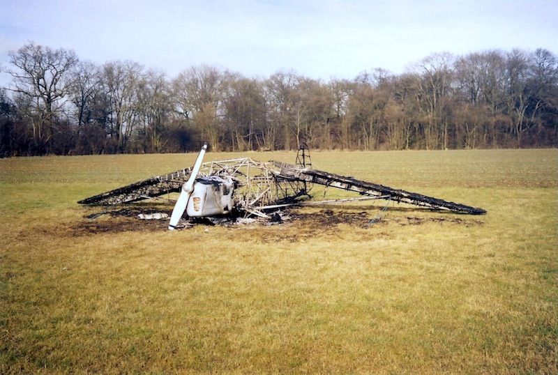
I actually dont know where this was. Saddest photo I've ever seen.
Caused, it seems, by someone trying to steal fuel...

Join Date: Sep 2012
Location: Sisteron, France
Age: 67
Posts: 79
Likes: 0
Received 0 Likes
on
0 Posts
Hello all! Long time no see...
I believe we are in OH mode so, here is another one of my pet war airfields:

This one has very interesting remnants to this day...It is located in my usual sector!
Cordially
Asw22

I believe we are in OH mode so, here is another one of my pet war airfields:
This one has very interesting remnants to this day...It is located in my usual sector!
Cordially
Asw22

Well asw22 is probably still chasing thermals, so I'll give you a clue: it's in the 'departement Pas de Calais'. And that's about all that remains from the large concrete runway, looking southwards. (courtesy of Mr. Google)

Taking off on the westerly runway, with the ATC instruction "maintain runway heading for well over 100 miles" would bring you right over Shoreham airfield. Well... "immer gerade aus" would be the more likely "Befehl" from the "Fluglotse" to go and bomb Shoreham

Taking off on the westerly runway, with the ATC instruction "maintain runway heading for well over 100 miles" would bring you right over Shoreham airfield. Well... "immer gerade aus" would be the more likely "Befehl" from the "Fluglotse" to go and bomb Shoreham
Join Date: Dec 2011
Location: With Wonko, outside the Asylum.
Age: 56
Posts: 489
Likes: 0
Received 0 Likes
on
0 Posts
DIBO, perhaps you'd like to name the airfield and declare OH or post your own challenge?
There's a strange feeling of mild annoyance when we have challenge responses which indicate someone knows the answer, but isn't saying, and motivation to research them ends up somewhat less...
If asw22 isn't around to respond, then what would happen to a correct answer?
Should we just move on? The others (especially cockpit) seem to have atrophied, is this thread going the same way?
A few days late and a couple of dollars short - sad to see the J1N - learned to fly on that model in 1961, though not in that aircraft. Hope they got the bu@@ers who (allegedly) tried to steal the fuel.
I didn�t want to steal ASW22�s show, awaiting his return I just wanted to give some clues to keep the quiz going. I tried to find it myself �the honest way�, but I couldn�t, so used some CSI techniques but it still took me 15 min. or so to wade through all possible matches. ASW22�s picture was not in the database (and didn�t find it yet on the www). It wouldn�t be very sportsmanlike to give the answer, but didn�t want to annoy anybody by withholding the answer, either. I�d hoped some extra clues would get the quiz going.
Although most of the RWY�s have gone, most of the airfield perimeter is still in use (more or less) and is largely StreetViewed. Never been able to �drive around� that much on WW II concrete.
For those still in the quiz, some more clues:
Although most of the RWY�s have gone, most of the airfield perimeter is still in use (more or less) and is largely StreetViewed. Never been able to �drive around� that much on WW II concrete.
For those still in the quiz, some more clues:
- It is RWY29�s extended centreline that brings you in the Shoreham area, after some half an hour flying at Me109 speeds. ASW22�s picture is north oriented.
- For the nature lovers, the main landscape feature in asw22�s picture, the forest, is still in good, similar shape, even having reclaimed the dispersal TWY on the eastern side. With Google Earth from about 25km altitude, you can spot it fairly easy (if you�ve worked out the general area).
- Lots of WW I fighting must have been going on, lots of cemeteries. This village has a British cemetery with a New Zealand memorial (haven�t got a clue if this is a sensible clue).
