


RAF Sharjah

Join Date: Jan 2012
Location: Knole Somerset
Age: 78
Posts: 123
Received 0 Likes
on
0 Posts
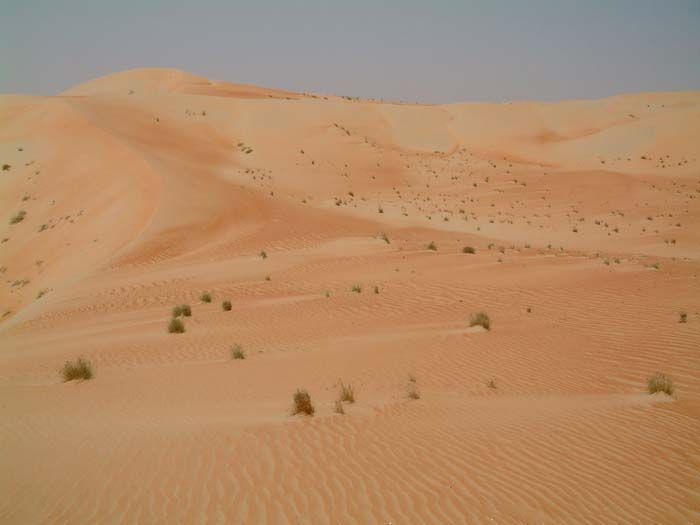
Liwa Hollows
We certainly operated into the Liwa Hollows in 1966. I seem to remember we operated on a back bearing from the Abu Dhabi NDB and then used dune maps. I am not sure but I think the main strip we used in the Hollows was Humar but I could be wrong. We certainly found the dune maps very accurate. Happy days before GPS!! Great map of Baraimi

Join Date: May 2007
Location: Europe
Posts: 1,416
Likes: 0
Received 0 Likes
on
0 Posts
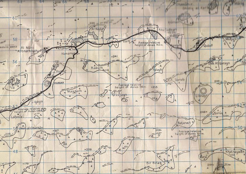
Here's another one that might bring back memories...Saiq in the SE corner, Rostaq at the top...the marks will be dried sweat, I think.....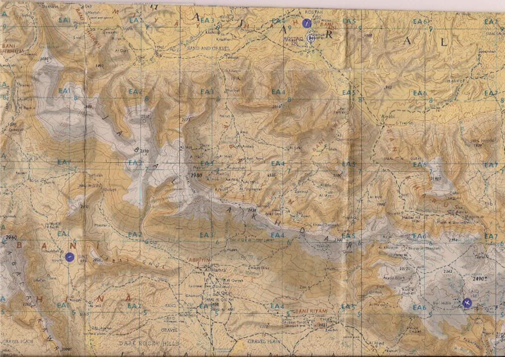
Last edited by Capot; 1st Feb 2013 at 18:09.
Join Date: Aug 2007
Location: Switzerland
Posts: 609
Likes: 0
Received 0 Likes
on
0 Posts
Very nice Capot. Fits in well with some of my stuff. The oblique runway near "TWO" might be Daudi, the old Al Ain strip that brakedwell remembers, with a quick Landrover trip to cool "drinks" in Jahili Fort. Also the Oasis Hospital, the first in Al Ain. I don't see the Hamasa strip next to Buraimi fort though.
Nice.
Laurence
Nice.
Laurence
Humar
navstar1. I could have done with that dune map! There were no NDB's available in 59/61, so we had to use dead reckoning from the oil company strip at Tarif. I only failed to find Humar once when the vis was very poor in blowing sand. I always stayed with the aircraft, often on my own, while the passengers together with the nav or sig were driven to the TOS camp. I will always remember the first time I heard desert bells shortly after the sun slipped below the dunes.
Last edited by brakedwell; 1st Feb 2013 at 21:45. Reason: title added
Join Date: May 2007
Location: Europe
Posts: 1,416
Likes: 0
Received 0 Likes
on
0 Posts
Humar
Brakewell, I realsie that it may be a bit late to be of much use to you, but here's a very small part of the Liwa Hollows 1963 map, showing Humar. The black line is the main track, and a regular patrol route. Below it there's part of a BP map used in the early 70's, just for interest. Humar is marked, 2nd strip, counting from the West in the Liwa. Not a very good scan, I'm afraid.
I hope these pictures aren't too big!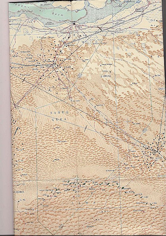
Last edited by Capot; 1st Feb 2013 at 23:38.


Join Date: May 2007
Location: Europe
Posts: 1,416
Likes: 0
Received 0 Likes
on
0 Posts
Navstar
Humar is marked on the dune map; about halfway up the picture towards the left hand side.
On the BP map, it's at about 10.00 o'clock on the top edge of the Liwa, if 12.00 o'clock is the centre of the top edge of the semi-circle. You can see the red airstrip sign, just, but the name is unreadable. It's the 2nd airstrip along the top edge, counting from the left-hand side of the picture. Incidentally, the pencilled course lines (with time or distance marks) disappearing to the NW go to Jebel Dhanna and/or Tarif. I'm not sure why there are two routes to Asab; was there a 1-way system in the '70s? It would have made sense, there was a lot of civil and military traffic between the desert strips, all low-level, often in very hazy conditions.
Re navigation in the Twin Pins; I'm sure that Bimbo Ward taught me to use a drift sight in one of those, as well as to make sure that no-one was running up and down the cabin when trying and failing to set the elevator trim. ("Tell you what, it's just you 'n me, you fly it, head for Sharjah, keep it at 3,000 ft, I'll have a zizz in the back".) Were drift sights fitted? Or is it a memory lapse?
Last edited by Capot; 2nd Feb 2013 at 10:36.
Humar
Thanks Capot, very interesting. I can't remember seeing any tracks across the grey sand in the Humar depression. navstar1, the TOS camp was a few miles from the strip and was very basic then. We almost night stopped in Humar once when the cartridge starter system failed and I was left holding the starter knob and three feet of broken bowden cable. A landrover was despatched to the camp to collect a length of rope and a hessian sack, which was folded into a triangle, securely attached to the rope, and slipped over a prop blade before rotating it to the upper vertical position. It was dark when three TOS officers took hold of the rope and I shouted "3-2-1 RUN!" After several failed attempts the engine fired and they climbed on board for a take-off in starlight. My emergency starter system was carried on all future Sharjah detachments. Does anybody remember reloading the six shot revolving cartridge starter, which was inevitably covered in oil, too hot to handle and more often than not the OAT was over 40C?
Join Date: Jan 2012
Location: Knole Somerset
Age: 78
Posts: 123
Received 0 Likes
on
0 Posts
Drift Sights
They certainly were fitted. I think by the navigator by his right hand seat or just behind the bulkhead on the right hand side. That ,the NDB and the mark one eyeball was the nav equipment on the Twin Pin!
Join Date: Jan 2012
Location: Knole Somerset
Age: 78
Posts: 123
Received 0 Likes
on
0 Posts
Cartridge Starter
Changed it many times although we always let it cool down first! We carried the same emergency starter kit and I remember once we attached the end of the rope to a truck. Worked a treat
Join Date: May 2007
Location: Europe
Posts: 1,416
Likes: 0
Received 0 Likes
on
0 Posts
Rope-starting, with a landrover, worked a treat on the Gulf DC3s as well; the spinner appeared to be designed for the purpose, rather than using a blade. At least that's how I remember it, perhaps wrongly.
The DC3 'book' procedure uses 2 of the blade tips, 2 rubber sleeves for the tips (bits of hessian if the sleeves were left behind?), a rope and 3 athletes. The 3 TOS officers used by Brakedwell would have been athlete substitutes at best, but the engine might have been a bit easier to crank.
The DC3 'book' procedure uses 2 of the blade tips, 2 rubber sleeves for the tips (bits of hessian if the sleeves were left behind?), a rope and 3 athletes. The 3 TOS officers used by Brakedwell would have been athlete substitutes at best, but the engine might have been a bit easier to crank.
Last edited by Capot; 2nd Feb 2013 at 10:52.
Join Date: Oct 2012
Location: Australia
Age: 79
Posts: 30
Likes: 0
Received 0 Likes
on
0 Posts
Hand starts
Rather than muck around with the hot cartridge starter, hand starts were a pretty regular thing in 1965. I recall a run-up, jump to grab the prop, drop and swing, and keep on running (not into the next prop, of course!). OH&S would have a fit these days.
Last edited by leesaranda; 2nd Feb 2013 at 21:48.
