


Paul Holmes and Erebus

Amman, most ASPAs (well the ones I have had to avoid) have a minimum altitude of 2500 feet overflight to protect the wildlife. I'll check for Cape Hallet, but suspect it would be no different.

Guest
Posts: n/a
I suggest it's common sense that before beginning a VMC descent in a mountainous area, without any ground aids available, you first visually identifiy the mountain(s) itself. To me that just seems intuitively basic to any philosophy espousing "fail safe flying."
Join Date: Feb 2008
Location: New Zealand
Age: 64
Posts: 523
Likes: 0
Received 0 Likes
on
0 Posts
Compressor Stall: Thanks for the clarification. I'm sure the little penguins could handle a DC10 that's 33000 feet away.
Prospector: I vaguely recall reading something about skua gulls and height limits. They're definitely big birds. (The other large flying bird in the region is a species of albatross, but they tend to fly low, using ground effect.)
Prospector: I vaguely recall reading something about skua gulls and height limits. They're definitely big birds. (The other large flying bird in the region is a species of albatross, but they tend to fly low, using ground effect.)
In my experience, I don't recall seen a skua in flight from the air in the cruise below 10K, and I've flown along ~1/3 of the Antarctic coastline at 6000 feet or below. (On low level survey, however, <1000' I've seen a lot of birds including skuas, but that's irrelevant to the discussion).
I'm not comfortable criticising any risk analysis regarding altitudes for skua avoidance around the McMurdo area, especially as I've only flown into and out of the Ross Sea area to/from flight levels.
Having said all that, it's all a matter of likelihood and consequence. I believe that chances of a QF/DJ 737 hitting a small "fire hawk" (similar sized bird) in outback Australia would be at least one order of magnitude higher. However a buggered engine in Kalgoorlie is not as much of an issue as a buggered engine at 78S.
Guest
Posts: n/a
compressor stall,
Thanks, do you still have that photo approaching McMurdo Sound taken from the flight levels? as I recall it showed Ross Island, Mt Erebus and Beaufort Island to perfection. It showed the likely difference in weather conditions that previous flights had for a VMC descent as against the conditions that were prevailing for Capt Collins flight.
Thanks, do you still have that photo approaching McMurdo Sound taken from the flight levels? as I recall it showed Ross Island, Mt Erebus and Beaufort Island to perfection. It showed the likely difference in weather conditions that previous flights had for a VMC descent as against the conditions that were prevailing for Capt Collins flight.
Join Date: Nov 2011
Location: Boston
Age: 60
Posts: 49
Likes: 0
Received 0 Likes
on
0 Posts
Originally Posted by ampan
Chris Iz - They checked the black box to see what happened at Cape Hallett. This is from MB Wylie, an NZ government accident inspector:
Originally Posted by FGD135
You don't even need to know your position - you can be totally lost!
Join Date: Feb 2008
Location: New Zealand
Age: 64
Posts: 523
Likes: 0
Received 0 Likes
on
0 Posts
Chris Iz: I wouldn't disagree with FGD135. The best description I've read was on the other Erebus thread, by someone with the moniker of Bryan Abraham, who used the phrase "VMC bubble". This was another of those VMC/IFC accidents, just like JFK Jnr. He thought he could follow the lights along the coast to Martha's Vineyard, but couldn't see the cloud ahead, because it was dark. Once he entered the cloud, he lost all visual reference and couldn't distinguish up from down. If he had bothered to get his instrument rating, it would have been drummed into his head that he was to ignore his eyes and fly solely on his instruments.
Guest
Posts: n/a
It is not necessary to see and identify ground obstacles before switching to visual flight, but you must be in VMC at that point (in order to see that you can continue in VMC). You don't even need to know your position - you can be totally lost!
If you are on an IFR plan you would be flying, normally, on a track from beacon to beacon, or with modern gear, GPS, direct to your destination.
If you wanted then to proceed VMC, weather permitting, which is normally requested for a descent to destination you could request a VMC descent. This to save the round about way of descent via an Instrument Approach Procedure. If, after requesting VMC flight, you do not wish to proceed directly to your planned destination then you must advise the controller, .cancel your IFR plan and proceed VFR.
Or that's the way it used to be.
Last edited by prospector; 20th Dec 2011 at 05:24.
Join Date: Apr 2008
Location: Australia
Posts: 669
Likes: 0
Received 0 Likes
on
0 Posts
I would not agree with that statement.
There is no law or rule that I know of that says you must know your position before switching to visual navigation. Similarly, there is no law for the reverse situation (switching from visual navigation).
Note that we are not talking about switching from IFR to VFR. The aircraft can still be following IFR procedures whilst navigating visually.
That's what I used to think until I encountered commercial pilots on internet forums. How many do you think would agree with you?
Is it a requirement that an IFR aircraft that is switching from navaid/RNAV navigation methods to visual navigation must know its position before making the switch?
My statements in this area have been to address an apparent belief held by chris lz that a pilot must be certain of his position before switching to visual navigation.
There is also no law against being lost or uncertain of position!
Join Date: Nov 2011
Location: Boston
Age: 60
Posts: 49
Likes: 0
Received 0 Likes
on
0 Posts
Originally Posted by FGD135
My statements in this area have been to address an apparent belief held by chris lz that a pilot must be certain of his position before switching to visual navigation.
1) is there a formal rule that states when switching from instrument flying to VMC you must first establish your position with (a high degree of) certainty?
2) If not, is the argument then that "certainty of position" is implied by any standard of responsible airmanship while VMC - at least with 300 pax behind you?
My thinking has been that either 1) or 2) must be correct.
Pilots: speak
Thank you
Join Date: Apr 2008
Location: Australia
Posts: 669
Likes: 0
Received 0 Likes
on
0 Posts
Sorry, but that is what happens in the real world.
chris lz, answers:
1) No
2) Yes
Note that an IFR aircraft may be navigated by visual means, if desired. The aircraft is still effectively IFR.
Similarly, a VFR aircraft may be navigated entirely via means normally utilised by IFR flights (e.g, using ground-based navaids such as VOR, NDB, DME or RNAV-based systems such as INS, GPS, LORAN, etc).
TE901 was being navigated visually, but was still operating to the IFR.
This is quite different from an aircraft that has switched from IFR to VFR. A VFR aircraft must conform to strict rules regarding visibility and separation from cloud, whereas an IFR aircraft navigating visually is not bound to those VMC requirements.
Join Date: Apr 2008
Location: Australia
Posts: 669
Likes: 0
Received 0 Likes
on
0 Posts
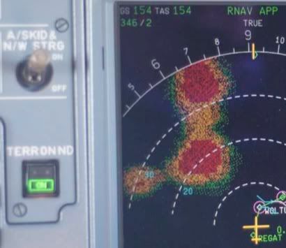
An absolutely striking image of Mt Erebus, Mt Terror and Mt Bird, thanks stallie!
Mt Erebus gets all the attention but to help appreciate the terrain of Ross Island, it is worth remembering that Mt Bird - the smaller of the three blobs - is itself almost 6,000' above sea level!
That image could not have come from any radar because it shows the mountains as circular shapes. A radar would only be able to see the sides facing the aircraft.
That image is from the EGPWS (Enhanced Ground Proximity Warning System), which has been regular equipment in airliners for only about the last 15 years.
Mt Erebus gets all the attention but to help appreciate the terrain of Ross Island, it is worth remembering that Mt Bird - the smaller of the three blobs - is itself almost 6,000' above sea level!
Hope that is not a Bendix radar, they will not show up Ross Is, despite what a number of crews said to the contrary.
That image is from the EGPWS (Enhanced Ground Proximity Warning System), which has been regular equipment in airliners for only about the last 15 years.
Join Date: Jul 2002
Location: UK
Posts: 3,093
Likes: 0
Received 0 Likes
on
0 Posts
Join Date: Nov 2011
Location: Boston
Age: 60
Posts: 49
Likes: 0
Received 0 Likes
on
0 Posts
Originally Posted by FGD135
Agreed!
chris lz, answers:
1) No
2) Yes
chris lz, answers:
1) No
2) Yes
- The crew's reliance on AINS resulted in plane hitting mountain
- The crew's reliance on ground aids would not have resulted in plane hitting mountain
-It follows that reliance on AINS is not a substitute for ground aids.
Evaluate.