


CDFA Calculation in Charts

Thread Starter

Joined: Aug 2024
Posts: 10
Likes: 1
From: Qatar
CDFA Calculation in Charts
Hello,
I'm trying to find the accurate formula which is used on a 2D and sometimes 3D approach which calculates the ALT you have to be at a specific distance for a CDFA. Using trigonometry yields a result which is off by 4' to 10' sometimes even more. Is the curvature of the Earth used for this calculations?
Ex.
LAX RWY 24R
My calculation to find 2,200' at 6.3nm from rwy threshold:
TDZE= 122'
Distance= 6.3nm
Alt= x
x= tan(3) * (6.3 * 6076.12)
x= 2006.1465' + 122'
ALT at 6.3nm = 2128.1465'... I'm off by roughly 70'+.
Any insight will be appreciated, thank you in advance.
Regards,
mabg


Thread Starter
Joined: Aug 2024
Posts: 10
Likes: 1
From: Qatar
Thank you for the reply, yes in most of the charts you do have the altitudes for each mile. Never the less I would like to understand and know the actual calculation in order to implement it into a project of mine.
Thread Starter
Joined: Aug 2024
Posts: 10
Likes: 1
From: Qatar
My Excel formula is (6076 * TAN (3/57.2) * 6.3 ) + 122 = 2182ft.
The difference is in the TAN calculation. On a calculator, if I input 3 TAN, I end up with your answer of 2128.
Using the TAN function in Excel, which needs the angle in radians, you get 2182.
Interesting!
Not yet. Other countries have had Distance/Altitude charts for decades but hey, what would they know. Maybe that's why SW tries to land 5nm short...
The number 57.2 that you are using after TAN represents what exactly?

Thread Starter
Joined: Aug 2024
Posts: 10
Likes: 1
From: Qatar
Any idea if the Altitudes of the charts are rounded up or do they implement the curvature of the Earth in the calculations? I feel that the trigonometry applied for my calculation are off by a good margin compared to the actual altitudes of the published charts.

Joined: Jan 2004
Posts: 3,246
Likes: 202
From: Here and there
I suspect it�s relatively simple. The table in Jeppesen for gradient to distance suggests it�s 319� per nautical mile. If there�s a more complicated formula behind the scenes, it�s not immediately obvious.
Joined: Mar 2002
Aviation Qualifications: ATPL
Posts: 9,225
Likes: 994
From: Seat 1A
Originally Posted by mabg88
The number 57.2 that you are using after TAN represents what exactly?
The 57.2 is the rounded number of degrees in a radian. Excel uses radians for TAN calculations so you have to divide the degrees by 57.2 to get the radians, then work out the TAN of that. More accurately, radians = degrees/57.2958.
Any idea if the Altitudes of the charts are rounded up or do they implement the curvature of the Earth in the calculations? I feel that the trigonometry applied for my calculation are off by a good margin compared to the actual altitudes of the published charts.
I'm off by roughly 70'+.
Re rounding, definitely. Have a look at the rounding on this D/A chart from one of my hometown ILSs. 3>4 is 320ft, 6>7 is 310ft.
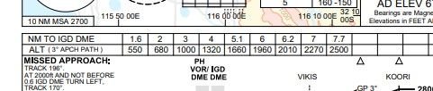
The 2200 at KOBEE could be 2195, or there may even be a convention where the number is rounded up (from say 2192 to 2200) to be on the safe side.
Fleet Manager

Joined: Apr 2001
Aviation Qualifications: ATPL
Posts: 7,448
Likes: 310
From: various places .....
you have to divide the degrees by 57.2 to get the radians
If you are going to the trouble of using the spreadsheet, better to use the normal conversion π/180.
I suggest, with your approach, that you are trying to measure a mile with a tape measure rather than an odometer ? End result is that you are playing with precision far finer than that inherent in the numbers to which you are making comparisons; with the result that you are getting needlessly confusing outcomes ?
J
Joined: Mar 2002
Aviation Qualifications: ATPL
Posts: 9,225
Likes: 994
From: Seat 1A
JT, I have to get REALLY close to my screen to see that... pie? 
I hope my name isn't mentioned in the crash report....
On a more serious note, I don't have a problem with people trying to understand what's going on on final and on the charts. The fact that the yanks don't have distance/altitude on some of their charts, I suspect, has contributed to prangs in the past and near misses in the recent past (SW).
Thread Starter
Joined: Aug 2024
Posts: 10
Likes: 1
From: Qatar
I'm curious about the calculations because for the past 9 years I've operated in and out of VNKT shooting the VOR which works well. Now the airport has installed a LOC antenna and they have a LOC only approach. Charted Altitudes and distance to cross check with mcdu are totally off meaning waypoints based on distance are not matching the chart same goes with the altitudes. Was curious to see if the chart was the issue by trying to understand the calculations. Sorry I'm not allowed to post URLs, was gonna show the LOC only app into KTM.
Thank you all for the replies, much appreciated.
Thank you all for the replies, much appreciated.
Joined: Jan 2004
Posts: 3,246
Likes: 202
From: Here and there
I'm curious about the calculations because for the past 9 years I've operated in and out of VNKT shooting the VOR which works well. Now the airport has installed a LOC antenna and they have a LOC only approach. Charted Altitudes and distance to cross check with mcdu are totally off meaning waypoints based on distance are not matching the chart same goes with the altitudes. Was curious to see if the chart was the issue by trying to understand the calculations. Sorry I'm not allowed to post URLs, was gonna show the LOC only app into KTM.
Thank you all for the replies, much appreciated.
Thank you all for the replies, much appreciated.
The 3.0� gradient is approximately 320' x distance to the threshold plus 4320 runway elevation plus 50' TCH. That formula gets me 5586' at 5.5 DME vs the charted 5590'.
Last edited by AerocatS2A; 15th August 2024 at 10:45.
Joined: Aug 2001
Posts: 696
Likes: 10
From: Shropshire
Hi Mabg
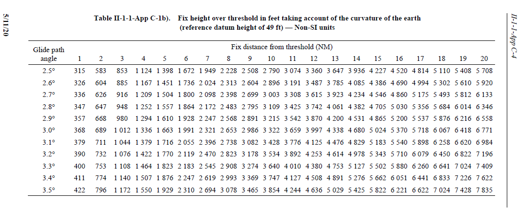
Generally earth curvature isn't considered within PANS-OPS unless you are creating an ILS approach with a final approach segment longer than about 5NM. There are tables included in PANS-OPS Volume II which give the height above threshold at various distances, whilst taking account of curvature of the Earth and an RDH of 49 ft:
Additionally, PANS-OPS includes this formula:
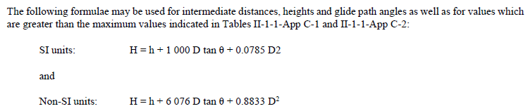
Note, the 'D2' in the SI units should be 'D squared' (the same as the Non-SI formula) and these formulae are for a quadratic equation i.e. for a parabola, so will be for a parabola that approximates the curvature of the Earth's surface over 'intermediate distances'.
Hope that helps
Cheers
TeeS
Generally earth curvature isn't considered within PANS-OPS unless you are creating an ILS approach with a final approach segment longer than about 5NM. There are tables included in PANS-OPS Volume II which give the height above threshold at various distances, whilst taking account of curvature of the Earth and an RDH of 49 ft:
Additionally, PANS-OPS includes this formula:
Note, the 'D2' in the SI units should be 'D squared' (the same as the Non-SI formula) and these formulae are for a quadratic equation i.e. for a parabola, so will be for a parabola that approximates the curvature of the Earth's surface over 'intermediate distances'.
Hope that helps
Cheers
TeeS
Last edited by TeeS; 15th August 2024 at 09:48. Reason: Punctuation
Joined: Aug 2001
Posts: 696
Likes: 10
From: Shropshire
Hi again Mabg
Sorry, I missed your post saying which approach you were interested in, that is challenging flying!!
On the subject of rounding; up to next 10ft in final segment; up to next 100ft in the intermediate segment, which must also include a 1.5NM level section for Cat C and D (1.0NM for Cat A and B) if there is a descent; and up to next 100ft in initial segment.
If you are using Excel for your calculations, I would suggest using the Radians() function to convert degrees to radians within your formula.
Cheers
TeeS

Eidolon
Joined: May 2001
Posts: 2,244
Likes: 62
From: Some hole
I'm curious about the calculations because for the past 9 years I've operated in and out of VNKT shooting the VOR which works well. Now the airport has installed a LOC antenna and they have a LOC only approach. Charted Altitudes and distance to cross check with mcdu are totally off meaning waypoints based on distance are not matching the chart same goes with the altitudes. Was curious to see if the chart was the issue by trying to understand the calculations. Sorry I'm not allowed to post URLs, was gonna show the LOC only app into KTM.
Thank you all for the replies, much appreciated.
Thank you all for the replies, much appreciated.
Last page is the LOC chart.
I haven�t had a looked at the MCDU for the approach, by any chance are these numbers what you are seeing ?
3.1nm 4860 ft
4.5nm 5550 ft
5.5 nm 6050 ft
7.5 nm 7030 ft
10.5 nm 8510 ft
11.5 nm 9000 ft
I worked those out based on a constant 4.637 degree slope between the FAF and the VDP, getting rid of the change from 5.31 to 3 degrees at 5.5 nm.
What does the coding look like in the MCDU, where does it say the descent starts ?
What decent angle is in the database ?
What are the database altitudes vs waypoints ?
Are you flying xLS or LOC-FPA ?
Is the software version on your MCDU temperature compensated for the approach ?
Joined: Apr 2009
Aviation Qualifications: Non-Aircrew
Posts: 1,601
Likes: 704
From: DM33
