Originally Posted by mabg88
The number 57.2 that you are using after TAN represents what exactly?
You're quoting a post that I deleted because I made a mistake with it. The 57.2 is rounded too much, which threw out my calculation.
The 57.2 is the rounded number of degrees in a radian. Excel uses radians for TAN calculations so you have to divide the degrees by 57.2 to get the radians, then work out the TAN of that. More accurately, radians = degrees/57.2958.
Any idea if the Altitudes of the charts are rounded up or do they implement the curvature of the Earth in the calculations? I feel that the trigonometry applied for my calculation are off by a good margin compared to the actual altitudes of the published charts.
I don't know. It could be the curvature of the earth; it would be easy enough for you to work out. You can find out the diameter of the earth and work from there.
I'm off by roughly 70'+.
No, you're only off by 15ft. Add the TCH to your numbers, because that raises the whole approach.
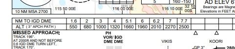
Re rounding, definitely. Have a look at the rounding on this D/A chart from one of my hometown ILSs. 3>4 is 320ft, 6>7 is 310ft.
The 2200 at KOBEE could be 2195, or there may even be a convention where the number is rounded up (from say 2192 to 2200) to be on the safe side.