CFIT Risk 3D BARO-VNAV & 2D Approaches


Joined: Jun 2012
Posts: 12
Likes: 0
From: Buenos Aires
Setting the wrong QNH, being given the wrong QNH or not setting QNH at all will always be a threat, especially to NPA but even to a precision approach. Even with a glide slope you could have a decision height below the runway elevation, which would only leave the radalt, assuming you have one, to save you from a surprise no-flare landing.
With nothing to cross check against, perhaps the easiest solution is for the pilot to read the QNH with the landing clearance if not visual, giving the tower controller a final chance to catch an error.
With nothing to cross check against, perhaps the easiest solution is for the pilot to read the QNH with the landing clearance if not visual, giving the tower controller a final chance to catch an error.
On an ILS you should be able to detect the misset QNH by doing distance altitude cross check. If actual QNH was 1003 and you had 1013 set, then you would cross the altitude crosschecks 300 ft above whats charted.
Joined: Jun 2012
Posts: 12
Likes: 0
From: Buenos Aires
I have always been amazed by the general lack of understading of most pilots of the higher risk asociated with QNH missets on RNP approaches using baro-vnav. Industry has been flying this kinds of approaches for a long time and we have just went on happily accepting a very possible catastrophic outcome by a single error with no barrier or crosscheck.


Only half a speed-brake

Joined: Apr 2003
Posts: 4,459
Likes: 136
From: Commuting not home
I have always been amazed by the general lack of understading of most pilots of the higher risk asociated with QNH missets on RNP approaches using baro-vnav. Industry has been flying this kinds of approaches for a long time and we have just went on happily accepting a very possible catastrophic outcome by a single error with no barrier or crosscheck.
All IAP charts in their respective AIPs need to have the RA HEIGHT published at the 1000' HAT distance point. As an addition to the international standard, respected and observed by the NAA/ANSPs.
Very easy to do, unambiguous and proper solution to what is a narrow but very deep hole lurking there. No need for ADS-B-whatever or CPDLC/S. Pure, old, tested and reliable geometry.


Joined: Sep 2011
Posts: 352
Likes: 148
From: FL390
Just to pitch an idea that floated on one of the previous threads, credit to Uplinker who I guess was the first to pronounce it loud.
All IAP charts in their respective AIPs need to have the RA HEIGHT published at the 1000' HAT distance point. As an addition to the international standard, respected and observed by the NAA/ANSPs.
Very easy to do, unambiguous and proper solution to what is a narrow but very deep hole lurking there. No need for ADS-B-whatever or CPDLC/S. Pure, old, tested and reliable geometry.
Worth bearing in mind that this will not work on some types (eg B787) as the 1000ft and 500ft auto call-outs are actually driven by barometric data.
Only half a speed-brake
Joined: Apr 2003
Posts: 4,459
Likes: 136
From: Commuting not home
Having said that, we may be skinning the cat from the opposite end. What I imagines was a boxed value such as
[RA 780]
[RA 1036]
[RA 1220]
at the 3.3 NM distance-to-threshold (or wherever the 3 deg nominal intersects exactly 1k HAT).
Joined: Dec 2003
Posts: 2,349
Likes: 844
From: Tring, UK
It�s a good idea and would likely work very well over flat terrain or the sea (where the CFIT chance is less) but I have no idea how accurate, precise or consistent RA readings are over hilly/forested/city areas, covering the range of aircraft that are going to be flying these approaches and the fact that there will be a lateral splay even on a precision approach, let alone a RNP one. Within the boundaries of the airfield, which is where we use RA to seriously measure stuff and make decisions based on the results, we�re over a level, solid surface. At the FAF and/or 3NM point there could be almost anything underneath that varies in height by hundreds of feet depending on your precise track.
Joined: Jan 2004
Posts: 3,246
Likes: 202
From: Here and there
I think the point is that �on track� on one approach isn�t exactly the same as �on track� on the next approach and variations in the terrain (aka �hills�) would make a radalt value too variable to be useful in some cases.
Only half a speed-brake
Joined: Apr 2003
Posts: 4,459
Likes: 136
From: Commuting not home
In agreement with all being said.
1000 equivalent RA check is a perfect safety anchor,oh except hard to quantify when the actual lateral track of overlying aircraft will have a sideways offset L/R about 100 mtrs.
Still an improvement, but not a salvation against QNH errors.
Joined: Dec 2005
Aviation Qualifications: ATPL
Posts: 4,997
Likes: 341
From: Hong Kong
The only way to be sure is to have a waypoint at which to carry out a RA/Baro crosscheck. In most cases with flat ground or water that's not a problem. Where it IS a problem, why not redesign the lateral track so that you DO fly over a something flat. And if there is nothing then use overhead the airfield at 2000', effectively turning it back into a procedural approach.
But you still have to remember to do the crosscheck.
But you still have to remember to do the crosscheck.

Joined: Jan 1999
Posts: 1,377
Likes: 174
From: England
The basic problem is that civil air traffic is still using altimetry procedures originally formulated many decades ago. It would be an interesting exercise to find out how many aircraft around the world were flying with mis-set altimeters at any one time. Crews failing to change from QNH to STD climbing through TA or vice versa during descent, or simply incorrectly set QNH. Fortunately such errors usually result in nothing more serious than red faces when they are discovered.
A 'European' problem which US pilots are spared is low TAs. Every time a severe low pressure weather system crosses the continent the authorities have to send out Notams reminding pilots about setting altimeters correctly in order to avoid level busts or terrain warning episodes. The irony is that such weather systems invariably bring severe low level turbulence. Concentrating on basic aircraft control might distract crews from re-setting their altimeters when required.
With tech refinements altimetry will probably eventually be via satellite signals, which will solve the problems of mis-setting. Transition levels consigned to history! Pressure altimetry (via data link with automatic adjustments to cross-check satellite signals) will be the back-up system.
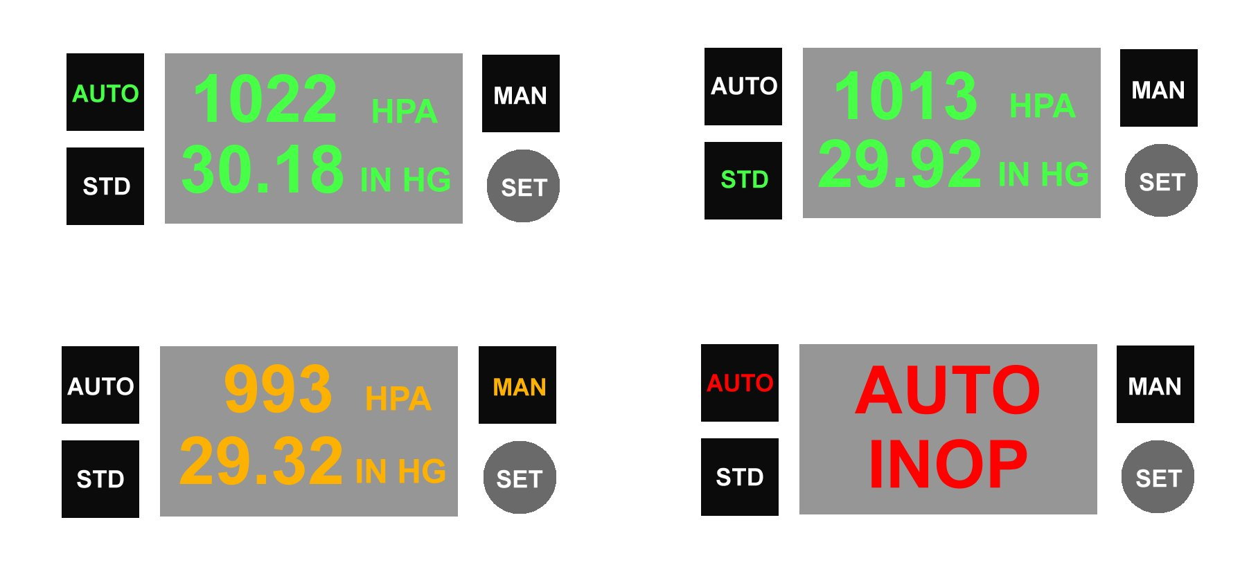
In the meantime here is a tech solution to incorrect QNH setting problem: ATC data base automatically transmits current local QNH to aircraft ADCs via data link - no humans involved! (Except to check for disparity between received QNH and expected QNH). Presentation in flight deck:
A 'European' problem which US pilots are spared is low TAs. Every time a severe low pressure weather system crosses the continent the authorities have to send out Notams reminding pilots about setting altimeters correctly in order to avoid level busts or terrain warning episodes. The irony is that such weather systems invariably bring severe low level turbulence. Concentrating on basic aircraft control might distract crews from re-setting their altimeters when required.
With tech refinements altimetry will probably eventually be via satellite signals, which will solve the problems of mis-setting. Transition levels consigned to history! Pressure altimetry (via data link with automatic adjustments to cross-check satellite signals) will be the back-up system.
In the meantime here is a tech solution to incorrect QNH setting problem: ATC data base automatically transmits current local QNH to aircraft ADCs via data link - no humans involved! (Except to check for disparity between received QNH and expected QNH). Presentation in flight deck:
Joined: Jan 2006
Posts: 457
Likes: 16
From: australasia
For once I heatedly agree with you Bloggs.
However, bear in mind that the areas that have low TA's/TL's generally have significantly more complex airspace requirements and significantly more traffic than is experienced in your usual area of ops.
It might just be a little more complex, than thinking of a suitable number, and then promulgating it.
Maui
Joined: Mar 2002
Aviation Qualifications: ATPL
Posts: 9,225
Likes: 993
From: Seat 1A
However, bear in mind that the areas that have low TA's generally have significantly more complex airspace requirements and significantly more traffic than is experienced in your usual area of ops.
Joined: Jan 1999
Posts: 1,377
Likes: 174
From: England
There'll be a few of these this year (and next and next &c). If the European TA was raised to 10,000 ft (or 18,000 to match the USA and clear Europe's highest terrain) the task of altimeter reset would be moved to a period of lower flight deck workload and therefore more likely to be dealt with correctly.