


UPS cargo crash near Birmingham AL

The following is from an FAA chart and lists the obstacles for a departure from RW36, i.e in the RW18 undershoot.
Rwy 36: Fence, tree, and vehicles on road beginning 130’ from DER, left and right of centerline up to 28’ AGL/662’ MSL. Tree and pole beginning 467’ from DER, 470’ right o fcenterline, up to 63’ AGL/726’ MSL. Trees beginning 637’ from DER, 420’ left of centerline, up to 13’ AGL/696’ MSL. Pole and tree beginning 1353’ from DER, 669 left of centerline, up to 37’ AGL/739’ MSL. Trees, poles, and fence beginning 1279 from DER, 492’ right of centerline, up to 19’ AGL/713’ MSL. Terrain beginning 43 feet from DER, left and right of centerline, up to 794’ MSL
DER=Departure end of runway.
On an FAA website I found an old version of the GPS approach and the descent angle was originally 3.04 degrees. Chart is dated July 2008.
Last edited by tubby linton; 18th Aug 2013 at 16:47.

Join Date: Feb 2000
Location: Alaska, PNG, etc.
Age: 60
Posts: 1,550
Likes: 0
Received 0 Likes
on
0 Posts
Tubby, that distance in the last item appears to be in error. It doesn't follow the trend in the list of getting further from DER, and 150 ft obstacles 43 feet from the runway??? 
Join Date: Jun 2001
Location: Rockytop, Tennessee, USA
Posts: 5,898
Likes: 0
Received 1 Like
on
1 Post
What does your fraternity of PIC and civil aeronautics do to honor their memory? Will a scholarship fund be established for their children or nieces or nephews or the kids at the local church temple mosque or yoga studio if they have none of their own? or at the Boy Scouts or Girl Scouts or 4-H or Explorers or the entity which the US ought to form combining all four of these groups? I began my career as a labor attorney and I don't even know if they were organized into a labor union! What can be done that will honor their memory, and at the same time help the taxpayers of this country realize that aviation safety doesn't just happen. It does not just happen by itself.
I'd gladly volunteer my legal services, saving to suitors the proverbial dollar (Sound as a Dollar), to set up a trust or scholarship. Or to press for legislative reform of how FAA updates approach corridors. I'm WillowRun Six-Three, good day.
I'd gladly volunteer my legal services, saving to suitors the proverbial dollar (Sound as a Dollar), to set up a trust or scholarship. Or to press for legislative reform of how FAA updates approach corridors. I'm WillowRun Six-Three, good day.
UPS plane crash: Pilot Shanda Carney Fanning's funeral, life celebration planned | al.com
Both pilots were members of this labor union: Independent Pilots Association
I have re-read that a few times and that is what is says . The reference is here:
https://charts.aero/airport/KBHM and the specific chart is Birmingham 5 cont.1
https://charts.aero/airport/KBHM and the specific chart is Birmingham 5 cont.1
BOAC, re "Yes thanks - do we have an initial impact elevation? "
Even given the inaccuracies described regarding Google Earth's topographical data, using the "ruler" tool in G.E. to draw a line from the 1000ft point on 18 along the approach path over the two houses (photographs showing broken trees), and using the Altitude control, "Clamped to ground" feature available when saving the line to "My Places", one can obtain a slightly better appreciation for the character of the terrain.
And using the Altitude feature, "Relative-to-ground" and placing the same line at the runway elevation, one can see that the line "disappears" anytime it is going through terrain higher than the altitude selected by moving the slider on the "ground - space" control.
Viewing from the side, (perpendicular to the approach course, looking north for example), the same line "Clamped to the ground" shows a rough approximation of the undulation of the terrain.
The limitations are obvious (for example, the actual descent path obviously cannot be described at this time) but with the cautions expressed, it does give one something by which one may roughly examine the terrain.
PJ
Join Date: Jul 2013
Location: Within AM radio broadcast range of downtown Chicago
Age: 71
Posts: 849
Received 0 Likes
on
0 Posts
I liked Harrison Ford's ambulance driving but, no
Sorry this was left obscured. Volunteer my legal services, no charge, free, except for a nominal One Dollar U.S. (unfolded). But not pro bono, which is a slightly different concept of service. I am interested in what sometimes is called public advocacy, not the same thing as pro bono publico, and quite a lot not the same as politics or running for public office. No relation whatsoever to the fee-chasing lawyers who try to sign up injured parties or their surviving kinfolks after an accident - thank you, not why I went to law school.
Thanks for the info on the memorial and the union.
See ya.
Thanks for the info on the memorial and the union.
See ya.
Per Ardua ad Astraeus
Join Date: Mar 2000
Location: UK
Posts: 18,579
Likes: 0
Received 0 Likes
on
0 Posts
Thanks, PJ - I do not have time (I am familiar with the process from wireless broadband mast siting) but if, as you say, the line 'disappears', it presumably means the airfield would have disappeared largely or completely from sight (allowing of course for cockpit height.) Viewing 4 reds through trees is not a preferred option.
Join Date: Jul 2013
Location: Within AM radio broadcast range of downtown Chicago
Age: 71
Posts: 849
Received 0 Likes
on
0 Posts
Terrain
PJ, sir, is it reasonable and accurate - based on the data actually in hand and the review, analysis or other cogitation by learned professionals especially and particularly PJ2 - to say that there appears to be a significant mismatch between the terrain measurements or depictions (or some similar element) upon which the approach corridor was designed - and the actual terrain? It appears that a major factor here will be a deficit in reliable and accurate topographic data? (subject to the above-noted qualification of data preliminary in nature and probable cause analysis yet to be stated). 
Join Date: Jul 2002
Location: Ireland
Posts: 596
Likes: 0
Received 0 Likes
on
0 Posts
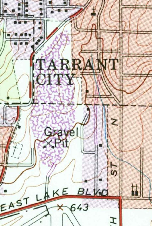
Latest topographical map of area.
Although unfortunately the contours aren't labelled but you can see that the initial impact point was to the west of the highest point on the ridge although that's where the cockpit section of the aircraft came to rest as the rest of it continued down the hill.

Join Date: Feb 2000
Location: Alaska, PNG, etc.
Age: 60
Posts: 1,550
Likes: 0
Received 0 Likes
on
0 Posts
PJ, sir, is it reasonable and accurate - based on the data actually in hand and the review, analysis or other cogitation by learned professionals especially and particularly PJ2 - to say that there appears to be a significant mismatch between the terrain measurements or depictions (or some similar element) upon which the approach corridor was designed - and the actual terrain? It appears that a major factor here will be a deficit in reliable and accurate topographic data? (subject to the above-noted qualification of data preliminary in nature and probable cause analysis yet to be stated).
Guest
Join Date: Apr 2009
Location: On the Beach
Posts: 3,336
Likes: 0
Received 0 Likes
on
0 Posts
Speed of Sound:
The dark contour line is 700 feet, msl. Trouble is, it is meaningless because so much surface material has been moved around since that chart was issued.
The dark contour line is 700 feet, msl. Trouble is, it is meaningless because so much surface material has been moved around since that chart was issued.
Join Date: Feb 2000
Location: Alaska, PNG, etc.
Age: 60
Posts: 1,550
Likes: 0
Received 0 Likes
on
0 Posts
Latest topographical map of area.
Although unfortunately the contours aren't labelled but you can see that the initial impact point was to the west of the highest point on the ridge although that's where the cockpit section of the aircraft came to rest as the rest of it continued down the hill.
Although unfortunately the contours aren't labelled but you can see that the initial impact point was to the west of the highest point on the ridge although that's where the cockpit section of the aircraft came to rest as the rest of it continued down the hill.
Aterpster's post with topo map.
And your view does not include the initial impact area, that was well to the north of your picture. The houses and streets in the north portion of your view have been removed. aterpster's map has a much close indication of the initial impact point. The aforementioned Ms Benson has stated that the airplane hit trees in her yard, and dropped airplane parts on her property which is located at the intersection of Tarrant-Huffman road and Treadwell road. That would be the intersection of the red and white striped roads, just west of the "impact" symbol on aterpster's map.
Join Date: Jul 2013
Location: Mosquitoville
Posts: 99
Likes: 0
Received 0 Likes
on
0 Posts
Originally Posted by A Squared
Quote: do we have an initial impact elevation?
The terrain in the vicinity of where the airplane started hitting trees is between 750 and 800 ft MSL. Trying to define it any closer than that without actually being there and measuring thing would be futile.
The terrain in the vicinity of where the airplane started hitting trees is between 750 and 800 ft MSL. Trying to define it any closer than that without actually being there and measuring thing would be futile.
This is based on the topo, and me actually taking a look at the site... so they were not below rwy elevation, but MDA is another matter....
Re Terrain profile / EGPWS alerts;
I recall a briefing by Honeywell at an operator’s conference (8 yrs ago ?) which indicated continuing improvements in the terrain clearance warnings to help avoid undershoots.
The terrain clearance floor (TCF) ‘cut off’ distance originally ended at 1nm from the runway threshold, but was to be reduced to 0.5nm assuming accurate runway detection and availability of survey data, which should be the case in the US.
A further reduction to 0.25 nm might be available with GPS based aircraft position. The effect of these changes would provide a warning boundary of 150 ft above threshold datum at 1.25nm to 0 ft at 0.25nm.
Does anyone have further details of this, and if the modifications were adopted which software mod package (SW 218-218)?
w.r.t. this accident what was the EGPWS mod state, and what navigation source was used for EGPWS position?
Join Date: Feb 2005
Location: flyover country USA
Age: 82
Posts: 4,579
Likes: 0
Received 0 Likes
on
0 Posts
Smilin_Ed:
The undulating terrain at KBMH would make any use of RA problematic. Recall that the Polish presidential Tu-154 that crashed in Russia 10 Apr. 2010 was using RA, which misled the crew as they approached over a ravine.
In that case, the ravine was below the airfield elevation; at KBMH the ravine (or other low terrain) was below the intevening hill.
Does this aircraft not have a radar altimeter?
In that case, the ravine was below the airfield elevation; at KBMH the ravine (or other low terrain) was below the intevening hill.
Join Date: Jul 2013
Location: Mosquitoville
Posts: 99
Likes: 0
Received 0 Likes
on
0 Posts
Originally Posted by Aterpster
The dark contour line is 700 feet, msl. Trouble is, it is meaningless because so much surface material has been moved around since that chart was issued.
WillowRun 6-3, I concur with A Squared's response. AFAIK, one would never use Google Earth's terrain data for such work or verification of such work.
I've plotted the approximate approach path described above but won't post it as it cannot be verified without proper topographic mapping data. The only intention was to view an approximation of the approach terrain, (hilly, vice flat, etc), possible visibility of the runway when lower than the IMTOY minimum altitude, etc. We may expect that the NTSB will do the precise work and the actual approach profile will be known then.
PJ2
Last edited by PJ2; 18th Aug 2013 at 18:36.
Join Date: Jul 2013
Location: Within AM radio broadcast range of downtown Chicago
Age: 71
Posts: 849
Received 0 Likes
on
0 Posts
Terrain, contd
PJ, I regret having interrupted the thread with an incorrect thought process. I shall continue with an effort (very inexperienced though it may be) to acquire a better understanding of the subject matters discussed herein, I mean, on this thread.
Guest
Join Date: Apr 2009
Location: On the Beach
Posts: 3,336
Likes: 0
Received 0 Likes
on
0 Posts
A Squared:
That would be the USGS Birmingham North and Irondale 1:24,000 topos.
I have no idea of the date of mine because they are WSG84 seamless bitmaps from Delorme. For my purposes they are usually fine because I am interested primarily in terrain.
That would be the USGS Birmingham North and Irondale 1:24,000 topos.
I have no idea of the date of mine because they are WSG84 seamless bitmaps from Delorme. For my purposes they are usually fine because I am interested primarily in terrain.
Join Date: Jul 2002
Location: Ireland
Posts: 596
Likes: 0
Received 0 Likes
on
0 Posts
No, that isn't the latest topo map of the area, it's the same vintage as the one previously posted by aterpster:
I downloaded it from the US Geological Survey website and assumed it was a contemporary map. It is actually from 1978.
But as Sorry Dog (who is local to the area) says, the grading was done between the foot of the hill and the end of RWY18. In that case we can assume that the ridge shown is 794’ MSL as the FAA notice will have used information from an actual survey of the terrain and the hill top remains unaltered from 1978.
When I said initial impact I meant with the ground rather than the trees as I was referring to the area contained within the portion of the map I posted.