


WHY DIFFERENT MDA FOR CIRCLING APP ON RECIPROCAL R/Ws

Per Ardua ad Astraeus
Join Date: Mar 2000
Location: UK
Posts: 18,579
Likes: 0
Received 0 Likes
on
0 Posts
I can only access the AIP charts and they look as if they have been done by a six-year old! The VOR26 is designated 'CAT A/B' but has minima for CAT C. NDB 26 is designated 'CAT A/B/C' but does not show any minima for CAT C (finger trouble?)
It appears that CAT A/B you circle on 08 from the VOR using a DA of 890'.
Cat C/D you cannot operate in at all!?? There do not appear to be any charts.
CAT A/B you circle on 26 from the VOR using a DA of 680' Cat C/D 890'
Using the NDB for some bizarre reason you use a DA of 680' CAT A/B and I would GUESS 840'for CAT C/D (Which I suspect is a chart error!)
Good luck! It would be useful to see what JEPP/AIG make of this.

Guest
Join Date: Apr 2009
Location: On the Beach
Posts: 3,336
Likes: 0
Received 0 Likes
on
0 Posts
Per Ardua ad Astraeus
Join Date: Mar 2000
Location: UK
Posts: 18,579
Likes: 0
Received 0 Likes
on
0 Posts
Hmm. Still confusing, but Jepp have done well considering the source material!
I really cannot see why circling differs between runways under PANSOPS. There are no obvious obstacles.
Any idea why Cat C is so restricted?
I really cannot see why circling differs between runways under PANSOPS. There are no obvious obstacles.
Any idea why Cat C is so restricted?
Join Date: Dec 2007
Location: paradise
Posts: 559
Likes: 0
Received 0 Likes
on
0 Posts
coz even the straight in approaches are restricted to A&B only. Only NDB RWY 26 is authorized for cat C. I guess it's due to large offset between the RWY and final courses 
Per Ardua ad Astraeus
Join Date: Mar 2000
Location: UK
Posts: 18,579
Likes: 0
Received 0 Likes
on
0 Posts
Cannot see the logic. Cat C could easily circle off the 08 VOR.
Aterp - need some assistance here - what is 'FN26' on the NDB proc and the '4.3' and 3 degree slope - are we looking at PRNAV?
Aterp - need some assistance here - what is 'FN26' on the NDB proc and the '4.3' and 3 degree slope - are we looking at PRNAV?
Guest
Join Date: Apr 2009
Location: On the Beach
Posts: 3,336
Likes: 0
Received 0 Likes
on
0 Posts
BOAC:
It wouldn't be the first time PANS-OPS has been tortured by a less than sterling procedures staff.
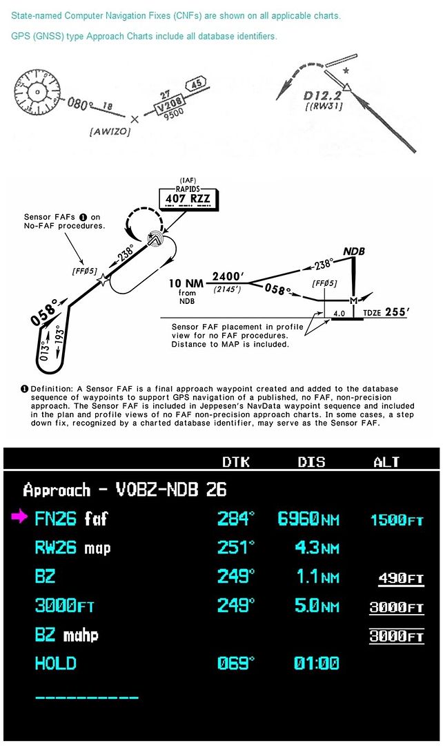
That is an On-Airport, No-FAF NDB IAP. Jeppesen has coded a sensor FAF for LNAV (RNAV), thus FN26. They have also coded a 3 degree VNAV path from FN26 to a 50' thresold crossing height. It is 4.3 miles from FN26 to the threshold.
Cannot see the logic. Cat C could easily circle off the 08 VOR.
Aterp - need some assistance here - what is 'FN26' on the NDB proc and the '4.3' and 3 degree slope - are we looking at PRNAV?
Per Ardua ad Astraeus
Join Date: Mar 2000
Location: UK
Posts: 18,579
Likes: 0
Received 0 Likes
on
0 Posts
1) Roger!
2) Is there a reference for the use of 'FN' - I suspect it is a TERPS point rather than a PANSOPS point, and should that chart not be annotated 'RNAV or perhaps 'APV(Baro)' in PANSOPS? I've been all over Jepp (on-line) and have not found anything.
2) Is there a reference for the use of 'FN' - I suspect it is a TERPS point rather than a PANSOPS point, and should that chart not be annotated 'RNAV or perhaps 'APV(Baro)' in PANSOPS? I've been all over Jepp (on-line) and have not found anything.
Guest
Join Date: Apr 2009
Location: On the Beach
Posts: 3,336
Likes: 0
Received 0 Likes
on
0 Posts
BOAC:
Any time a fix is in bracketts [FN26] it is a CNF; computer navigation fix. This is in the domain of RTCA and FMS engineers. It is neither TERPS nor PANS-OPS; rather it is a method of doing an FMS overlay of any ground-based procedure. If the state (India in this case) does not authorize RNAV overlay of the procedure per se, then it goes to the operator's authorization whether or not the underlying nav aid must also be monitored while flying the LNAV (RNAV) overlay.
2) Is there a reference for the use of 'FN' - I suspect it is a TERPS point rather than a PANSOPS point, and should that chart not be annotated 'RNAV or perhaps 'APV(Baro)' in PANSOPS? I've been all over Jepp (on-line) and have not found anything.
Join Date: Dec 2007
Location: paradise
Posts: 559
Likes: 0
Received 0 Likes
on
0 Posts
timed approach must be flown conventionally however aided by a FMS way point to commence the descent, quite few of them still out there. We don't have the approaches in the data base only the FN way point for aid the identification of descent point.
Guest
Join Date: Apr 2009
Location: On the Beach
Posts: 3,336
Likes: 0
Received 0 Likes
on
0 Posts
BOAC:
This graphic shows two references I found in the Jepp legend. The bottom graphic is the procedure loaded into the Garmin G-1000 trainer, which uses the same nav data as the actual hardware:
Thanks for the clarification - I take it it would 'exist' in the Jepp NAV database then? Is there a Jepp pdf or whatever explaining?
Per Ardua ad Astraeus
Join Date: Mar 2000
Location: UK
Posts: 18,579
Likes: 0
Received 0 Likes
on
0 Posts
Again thanks - I am familiar with 'ff05' but not 'FN' - I assume there is no significance to a pilot in the different lettering - 'ff' / 'fn'? I see also it does refer to a 'Jepp NavData waypoint'.
Incidentally, I reckon that Garmin database is incorrect - it shows 4.3 to the 'map' which is actually the BZ? How can the MAP be the BZ anyway with only a 2 degree track change from THLD? In fact, where IS the MAP on an RNAV approach like that? Surely if the idea is to fly a CDA at 3 deg the MAP must be on the approach track at 680/890 (not 490!)? It looks like someone in Jepp is as confused as I am . I do hope that is not the actual database for NDB26 at VOBZ
or there may be tears!
. I do hope that is not the actual database for NDB26 at VOBZ
or there may be tears!
Is 'RW26' actually south of the threshold in the database?
Incidentally, I reckon that Garmin database is incorrect - it shows 4.3 to the 'map' which is actually the BZ? How can the MAP be the BZ anyway with only a 2 degree track change from THLD? In fact, where IS the MAP on an RNAV approach like that? Surely if the idea is to fly a CDA at 3 deg the MAP must be on the approach track at 680/890 (not 490!)? It looks like someone in Jepp is as confused as I am
. I do hope that is not the actual database for NDB26 at VOBZ
which uses the same nav data as the actual hardware:
Is 'RW26' actually south of the threshold in the database?
Guest
Join Date: Apr 2009
Location: On the Beach
Posts: 3,336
Likes: 0
Received 0 Likes
on
0 Posts
BOAC:
Highly unlikely that Garmin's database is any different from any other FMS that uses Jeppesen data.
The legal MAP is the NDB, which is 1.1 miles beyond the threshold. Why they coded a different MAP is beyond me. There are many of these remaining in the U.S., (VOR or NDB overlays) but when there were Jepp didn't move the MAP.
Incidentally, I reckon that Garmin database is incorrect - it shows 4.3 to the 'map' which is actually the BZ?
The legal MAP is the NDB, which is 1.1 miles beyond the threshold. Why they coded a different MAP is beyond me. There are many of these remaining in the U.S., (VOR or NDB overlays) but when there were Jepp didn't move the MAP.
The reason is that circling minima can never be less than the straight-in minima. Consequently, differing minima for the runway approaches may result in the circling minima being raised for one runway only.
Circling minima are calculated independently of the navigation aid used, and have different obstacle clearance requirements and a fixed visibiity requirement.
Straight-in minima are determined dependent on the navigation aid used, and visibility requirements may vary dependent on visual aids available and the MDH. If these are greater than the equivalent circling minima, the circling values must be raised.
Per Ardua ad Astraeus
Join Date: Mar 2000
Location: UK
Posts: 18,579
Likes: 0
Received 0 Likes
on
0 Posts
Aterp - if that is a genuine Jepp product you have screenshot then there is a serious error which needs addressing with great urgency. The MDA is dangerously wrong!
Still no logical explanation from anyone for two different circlings at VOBZ. Is it just a co-incidence that the CAT C circling alt for 26 is the same as the VOR minima CAT A/B for 08? Bizarre!
Still no logical explanation from anyone for two different circlings at VOBZ. Is it just a co-incidence that the CAT C circling alt for 26 is the same as the VOR minima CAT A/B for 08? Bizarre!
Originally Posted by BOAC
I am familiar with 'ff05' but not 'FN' - I assume there is no significance to a pilot in the different lettering - 'ff' / 'fn'? I see also it does refer to a 'Jepp NavData waypoint'.
Originally Posted by Aterpster
The legal MAP is the NDB, which is 1.1 miles beyond the threshold. Why they coded a different MAP is beyond me. There are many of these remaining in the U.S., (VOR or NDB overlays) but when there were Jepp didn't move the MAP.
Of note is that the database track from the "FAF" waypoint eg from FN26 to RW26 will not be the charted track if the navaid is offset. Because of an ARINC rule ("if FF, RWY and MAPt all lie within 0.14nm of the same track"), Jepp are able, and do, code direct to the RW26 waypoint from FN26. Obviously, if the navaid is offset, the flown track will diverge from the charted track, with the aircraft tracking "straight" at the threshold whilst being offset (requiring a double-turn when Visual), instead of crossing the centreline at around the MDA on the charted track, requiring only one turn onto final. Practically, this can be a real problem as the crew is presented with a significant double-turn to get lined up on final after becoming Visual.
Guest
Join Date: Apr 2009
Location: On the Beach
Posts: 3,336
Likes: 0
Received 0 Likes
on
0 Posts
BOAC:
The two VOR IAPs don't have an altitude coded at that point. Why the 490 on the NDB is beyond me. It does seem to be a coding error. Nonetheless, a properly trained crew is to predicate MDA on the chart, not anything in the database.
That is a question only the Indian procedures design staff could answer.
Aterp - if that is a genuine Jepp product you have screenshot then there is a serious error which needs addressing with great urgency. The MDA is dangerously wrong!
Still no logical explanation from anyone for two different circlings at VOBZ. Is it just a co-incidence that the CAT C circling alt for 26 is the same as the VOR minima CAT A/B for 08? Bizarre!
Per Ardua ad Astraeus
Join Date: Mar 2000
Location: UK
Posts: 18,579
Likes: 0
Received 0 Likes
on
0 Posts
Capn Bloggs - useful stuff there. I hope, however, in Oz you have the CORRECT DA in your coded approaches
Sure gets complicated when you 'twist' an offset approach into a straight-in for a computer - how do you GET to the MAP if it is the NDB and if it isn't, how is the obstacle splay affected by 'moving' the MAP to either the threshold or abeam the NDB?
Presumably if you went round off Aterp's VOBZ NDB26 you would need to go left to pick up the NDB 250 track - or would you just fly the 'RNAV' track to the north of the correct track? My head hurts.