


WHY DIFFERENT MDA FOR CIRCLING APP ON RECIPROCAL R/Ws

9.G, as I said above, "Overlay Approaches" simply do not exist here, nor do the US rules on flying them. If an NPA is in the DB, we can use LNAV and VNAV to fly it provided we monitor the raw data info.
The NDB 26 at VOBZ does have the top-of-the-drop waypoint; FN26, which is coded 3�, as shown, to the RW 26 waypoint.
Putting it another way, if the approach chart doesn't have the FMS waypoints, it's probably not going to be in the DB (all made by the same company), and guess what: we wouldn't fly it in LNAV/VNAV.
please have a closer look at Jeppesen plate 16-1 YPKA on lateral & vertical profile VPA is depicted in brakets (3,00) starting from FN08Y till EP08 whereas neither VOBZ bor ZMUB do have it depicted this way.
Putting it another way, if the approach chart doesn't have the FMS waypoints, it's probably not going to be in the DB (all made by the same company), and guess what: we wouldn't fly it in LNAV/VNAV.

Guest
Join Date: Apr 2009
Location: On the Beach
Posts: 3,336
Likes: 0
Received 0 Likes
on
0 Posts
9.G:
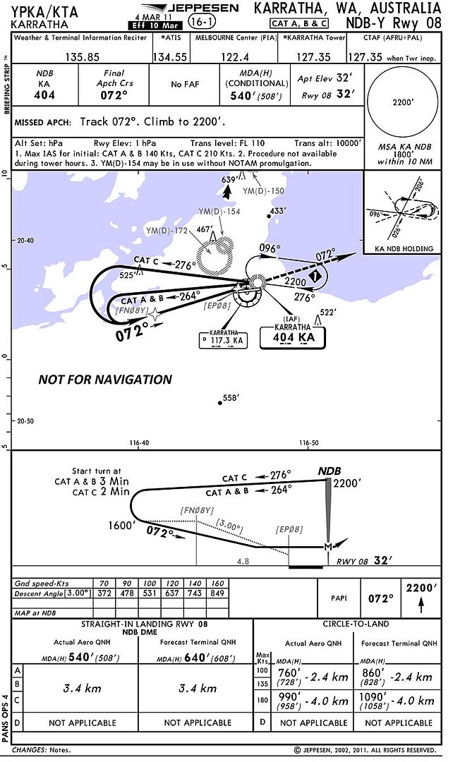
C.B, please have a closer look at Jeppesen plate 16-1 YPKA on lateral & vertical profile VPA is depicted in brakets (3,00) starting from FN08Y till EP08 whereas neither VOBZ bor ZMUB do have it depicted this way. I dunno how to copy paste it here perhaps someone else will be helpful. However here's something to think about:
Join Date: Dec 2007
Location: paradise
Posts: 559
Likes: 0
Received 0 Likes
on
0 Posts
Thanx aterpster, this is Jepp explanation about VNAV coding and how it's depicted on the charts. It's available on the new briefing strip concept description.
VERTICAL NAVIGATION (VNAV)
Vertical Navigation (VNAV) descent information will appear in the profile view of selected non-precision approaches beginning with charts dated 3 Dec 1999. The VNAV information appearing in the profile illustrates the geometric descent path with a descent angle from the Final Approach Fix (FAF) to the Threshold Crossing Height (TCH) at the approach end of the runway.
The VNAV descent path, depicted with a screened line, is based on the same descent angle coded into the Jeppesen NavData database. Use of this descent angle by certified VNAV-capable avionics equipment will ensure a stable, constant rate of descent that will clear all intervening altitude restrictions. Some approach procedures may require a delay of the start of descent beyond the FAF, until the VNAV descent path is intercepted. The profile view will depict this level segment of flight as required.
The VNAV descent angle appears in brackets along the VNAV descent path and is repeated in the conversion table. Additionally, the conversion table provides a recommended rate of descent relative to the VNAV angle and groundspeed.
The inclusion of the VNAV descent angle does not change or modify existing non-precision approach requirements. Usage of the Minimum Descent Altitude (MDA), as well as the Missed Approach Point (MAP), remains unchanged. In accordance with Federal Aviation Regulations (FARs) and ICAO PANS OPS criteria, do not descend below the MDA until attaining the required visual reference. Additionally, do not initiate the prescribed missed approach procedure prior to reaching the published missed approach point.
NOTE: Operators may obtain permission from their controlling authority to use Decision Altitude (DA) operational techniques when making a VNAV descent. This approval is specific to the operator and to the approach.
VNAV descent is optional. Use of any VNAV approach technique is dependent on operator approval, certified VNAV-capable equipment availability, and crew training.
another question is when will the a/c commence the left turn once the approach has been armed over KA (IAF)? So far I personally haven't seen a coding for timed turn neither in Thales nor Honeywell.
Join Date: Apr 2001
Posts: 17
Likes: 0
Received 0 Likes
on
0 Posts
WHY DIFFERENT MDA FOR CIRCLING APP ON RECIPROCAL R/Ws
Depends on the position of the critical obstruction that affects each runway. Quite common to see different circling MDA for each runway.
Originally Posted by hotbouy
In Oz, the circling altitudes are common across the aerodrome to prevent confusion [as demonstrated above], except where an infrequently used procedure would unnecessarily raise the altitude to an unreasonable value. The Cairns NDB or VOR -B is a good example
 The circling MDA is the same for both runways, so why is this example an exception?
Thread Starter
Join Date: Jan 2010
Location: india
Age: 59
Posts: 68
Likes: 0
Received 0 Likes
on
0 Posts
circle to land diff r/w.. what ht to follow?
My doubt remains as follows:-
I am doing a non precision app for r/w 09. I come to MDA .. r/w not sighted .. go till MAP .. sight the r/w but am not placed well for 09 ( laterally or vertically) & decide to do circle to land 27.
Do i refer to circle to land alt for 27. This requires me to flip the new chart, else be prudent enough to have gone through it before.
What is the verdict?
I am doing a non precision app for r/w 09. I come to MDA .. r/w not sighted .. go till MAP .. sight the r/w but am not placed well for 09 ( laterally or vertically) & decide to do circle to land 27.
Do i refer to circle to land alt for 27. This requires me to flip the new chart, else be prudent enough to have gone through it before.
What is
the verdict?
If there was a possibility of circling and then landing on 27 after doing the 09 approach, I would have briefed it. If the circling MDA for 27 is higher, and your terrain clearance for your category (cat C: 400ft AGL; assuming day operations) can't be assured for the whole of the circle onto 27 (local knowledge required), to be on the safe side I'd do a missed approach and then do the 27 approach, although this would depend on your configuration and company policy.
It might be acceptable to zip back up to the 27 circling MDA and then circle as desired, particularly if you are still at the circling configuration, not landing config.
It might be acceptable to zip back up to the 27 circling MDA and then circle as desired, particularly if you are still at the circling configuration, not landing config.
