


AF 447 Search to resume

Join Date: Jun 2009
Location: Chesapeake Bay
Age: 79
Posts: 57
Likes: 0
Received 0 Likes
on
0 Posts
They are all to be found within the 1.5NM radius circle with the cyan border. In fact there are seven positions in that circle, all within the last recorded 24 hours.
It should be noted that the SEABED WORKER's tight position for the last day is within but a few kilometers of mm43's predicted point of water impact, a prediction he made many months ago based upon careful set and drift calculations and charted for us. Once a navigator (I still own a bubble sextant), and knowing how difficult, tedious, and tricky such calcs are, I would be proud to buy the first round, mm43!
The Google Earth .KMZ file has been updated here.
GB

F/ctl Rud Trv Lim Fault
Quote from HazelNuts39:
"From the 1st Interim Report:
o F/CTL RUD TRV LIM FAULT (2 h 10)
Meaning: This message indicates the unavailability of the rudder deflection limitation calculation function. The limitation value remains frozen at the current value at the time of the failure (until the slats extension command is given)."
Thanks for the correction to my previous post, HN39. It explains a lot.
bearfoil,
Purely on the question of this RTLU issue, are you still suggesting that the A330 system is less protective than comparable aircraft from other manufacturers?
Chris
Guest
Posts: n/a
Chris
I think that this aircraft lost all of its control surfaces while airborne. The report would have us believe they were washed off in the impact with the Ocean. Given the wide range of deflections available from the top of cruise, and the a/c's substantial speed, I believe it is a reach to say the surfaces (connected to the a/c) made it to the impact. The surfaces of each of the controls show that they were wrenched out of their mounts violently but symmetrically. The skin in each is remarkably free of punctures, wrinkling, dimpling and warping. The challenge in engineering aircraft is to spread stress across smooth and strong material, so that no one area may be compromised more than another. This approach is specific to air loading, notwithstanding the need for lightweight.
These panels show abrasion at airflow separation areas, but remain remarkably true to specified dimensions, no folding, no warping, no crushing, as would be expected in a water impact while attached.
In other words, those areas expected to fail in aerodynamic loading, hinges, skin, corners, and longitudinal stiffeners did so, absent the curling, crushing, bending and warping consistent with a water entry while fixed in place. I don't know that the 330 is preferred over another type or not, specific to flight control; this accident involved FBW as a 'cause' only collaterally, imo.
Join Date: Jun 2009
Location: brasil
Age: 58
Posts: 4
Likes: 0
Received 0 Likes
on
0 Posts
Sorry can�t resist to make a few questions, I have read most of the thread(s), and suddenly the scenario of the possible causes have moved to something catastrophic that happened at normal cruise. Does this mean that all that pitot tubes talkings was just total speculation with very little to no relevance for the accident to occurr?
To what is due this change?
Thank you
To what is due this change?
Thank you
Join Date: Jun 2009
Location: NNW of Antipodes
Age: 81
Posts: 1,330
Received 0 Likes
on
0 Posts
originally posted by taffazzi ...
Does this mean that all that pitot tubes talkings was just total speculation with very little to no relevance for the accident to occurr?
Does this mean that all that pitot tubes talkings was just total speculation with very little to no relevance for the accident to occurr?
The whole purpose behind this thread is to have the DFDR/CVR recorders found so that a thorough analysis can be made. Only then will the speculation presented as of today have some or no relevance, and in any event I am sure that results will be argued all over again. That is nature of the world that we live in.
mm43
Join Date: Jul 2009
Location: France - mostly
Age: 84
Posts: 1,682
Likes: 0
Received 0 Likes
on
0 Posts
The distortions of the frames showed that they broke during a forward motion
with a slight twisting component towards the left.
with a slight twisting component towards the left.
The deformations of the frames were probably the consequence of the water
braking the aircraft�s forward movement.
braking the aircraft�s forward movement.
Last edited by HazelNuts39; 17th May 2010 at 07:51.
Join Date: Jun 2009
Location: in a plasma cocoon
Age: 53
Posts: 244
Likes: 0
Received 0 Likes
on
0 Posts
new BEA communique (17th of may)
Hi there
The BEA has just released a communique in French:
Information, 17 mai 2010
No significant news, the two Remus have covered 500 square km more without succes and nothing about the analysis conducted by Thales & the Navy (to refine their initial estimate of the pingers location) and about the opportunity to send the Seabed Worker south again.
Jeff
Join Date: Jun 2009
Location: various areas
Posts: 225
Likes: 0
Received 0 Likes
on
0 Posts
I�m with bearfoil on this. I have sat and read intently for months.
Call it visual bias, however the recovered parts speak in the absence of else, here is why IMHO:-
- CB WX
- loss of att [all uesable] data
followed by
- Possible assem thrust/ rapid wing stall on one side [roll away from sat coverage]
- Hi-alt [aerodynamic corner] - how do most swept wing aircraft behave at high alt in stall, let alone assem thrust and no [att] ref data in sh1t WX?
- Swept wing roll spin [think about lateral loads and reversal on the vertical stab once in to the vertical]
- Vertical Stab lateral tearing of the attach points?!
- Vertical Stab attach point/s above RPB [cabin alt warn]
- Subsequent wing device damage by aerodynamic load in the wrong [non-normal] flight direction [rip up and out - trailing edge in to the air flow]
- Debris recovered?! [break apart at alt is consistent with things like the spoilers/surfaces, galley frame and other recovered bits and pieces that did not suffer high impact hard compression]
- Condition of recovered persons?!
- Cargo bay crew pod, was it squashed and ripped to bits as per high speed compression impact with water? NO
The photo of the circular rip out of the structure below the vertical stab attach points is the one clue that has remained with me throughout.
Super strong alloy structures will only tolerate a certain amount of reversing [lateral pull and rip force] before it roundels like it did in this case. Metallurgists???
Who knows how [and what] remained of the flying surfaces, and how they performed once the aircraft was descending with no forward [relative to track] airspeed initially.
What was left might have regained sufficient airspeed to have flown for a distance once it resumed airflow before further break-up, OR, it might be sitting on the sea floor any number of miles [radius given possible break-up descent trajectories] ahead/around the LKP.
Hideous scenario I know, but I don�t believe this aircraft was [as it was designed to fly - relatively] semi-controlled [forward/airflow flight] intact until meeting the ocean.
I hope like everyone else, that the recorders are found.
Call it visual bias, however the recovered parts speak in the absence of else, here is why IMHO:-
According to the BEA report the stops were at 7,9�.
- CB WX
- loss of att [all uesable] data
followed by
- Possible assem thrust/ rapid wing stall on one side [roll away from sat coverage]
- Hi-alt [aerodynamic corner] - how do most swept wing aircraft behave at high alt in stall, let alone assem thrust and no [att] ref data in sh1t WX?
- Swept wing roll spin [think about lateral loads and reversal on the vertical stab once in to the vertical]
- Vertical Stab lateral tearing of the attach points?!
- Vertical Stab attach point/s above RPB [cabin alt warn]
- Subsequent wing device damage by aerodynamic load in the wrong [non-normal] flight direction [rip up and out - trailing edge in to the air flow]
- Debris recovered?! [break apart at alt is consistent with things like the spoilers/surfaces, galley frame and other recovered bits and pieces that did not suffer high impact hard compression]
- Condition of recovered persons?!
- Cargo bay crew pod, was it squashed and ripped to bits as per high speed compression impact with water? NO
The photo of the circular rip out of the structure below the vertical stab attach points is the one clue that has remained with me throughout.
Super strong alloy structures will only tolerate a certain amount of reversing [lateral pull and rip force] before it roundels like it did in this case. Metallurgists???
Who knows how [and what] remained of the flying surfaces, and how they performed once the aircraft was descending with no forward [relative to track] airspeed initially.
What was left might have regained sufficient airspeed to have flown for a distance once it resumed airflow before further break-up, OR, it might be sitting on the sea floor any number of miles [radius given possible break-up descent trajectories] ahead/around the LKP.
Hideous scenario I know, but I don�t believe this aircraft was [as it was designed to fly - relatively] semi-controlled [forward/airflow flight] intact until meeting the ocean.
I hope like everyone else, that the recorders are found.
Join Date: Jun 2009
Location: in a plasma cocoon
Age: 53
Posts: 244
Likes: 0
Received 0 Likes
on
0 Posts
underwater sound propagation & multipath
Hello. I know that this kind of multipath may happen for airborne EM radar in a look-down configuration (versus the target) over a rough relief, but would it be possible for sound waves propagating in water and sonars (more curvy waverays than EM waves propagating in the air) over a rough seafloor ?

If yes, the waveform detection would be correct but the AoA would be largely biased... and I wonder if the new Thales sonar signal processing can/do make use of the real bathymetry as it was measured during the 1st phase.
Jeff
If yes, the waveform detection would be correct but the AoA would be largely biased... and I wonder if the new Thales sonar signal processing can/do make use of the real bathymetry as it was measured during the 1st phase.
Jeff
Join Date: May 2010
Location: MA, USA
Posts: 126
Likes: 0
Received 0 Likes
on
0 Posts
Originally Posted by Hyperveloce
I know that this kind of multipath may happen for airborne EM radar in a look-down configuration (versus the target) over a rough relief, but would it be possible for sound waves propagating in water and sonars (more curvy wave-rays than EM waves propagating in the air) over a rough seafloor?
The 37kHz signal is weak, attenuated by the water, and more easily absorbed and scattered by soft or rough surfaces than are lower frequency signals. I would not expect terrain reflected paths to produce strong signals, though every rule has an exception.
As for localization, it all depends on what Emeraude was using for transducers. An omni-directional transducer will not provide any localization at all, other than knowing that the source is "near" the receiver. If they used a towed line array, they could compute a bearing (with or without left-right ambiguity, depending on various techniques), but no elevation. If they used a two dimensional array, such as a bow dome sonar, they could, in principle, compute bearing and elevation. Any bearing information is likely to be more reliable than elevation because there is usually less horizontal deflection of signals than vertical (because of the prominent horizontally layered sound speed variations). BEA's second report implies that several sensors on Emeraude were used, but it does not detail any of them (not surprised, the details are likely classified). The best localization often comes from crossed bearings when the source is received at different locations. There is no way to directly compute range, because the pinger is asynchronous.
If yes, the waveform detection would be correct but the AoA would be largely biased... and I wonder if the new Thales sonar signal processing can/do make use of the real bathymetry as it was measured during the 1st phase.
Join Date: Jun 2009
Location: NNW of Antipodes
Age: 81
Posts: 1,330
Received 0 Likes
on
0 Posts
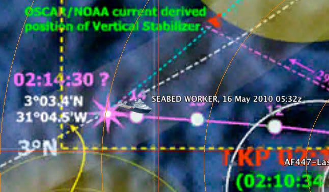
Update: "Seabed Worker" - position
Though these are somewhat delayed, the vessel's positions over the last couple of days follow:-
17 May 2010 19:46z Hdg 171.2 Spd 00.6 3�03'54"N 30�58'24"W
17 May 2010 17:55z Hdg 136.8 Spd 01.7 3�02'55"N 30�57'36"W
17 May 2010 09:05z Hdg 265.9 Spd 11.4 3�07'19"N 30�50'29"W
17 May 2010 07:21z Hdg 060.2 Spd 07.4 3�04'57"N 30�56'02"W
17 May 2010 05:40z Hdg 098.1 Spd 06.9 3�05'06"N 31�03'43"W
16 May 2010 20:52z Hdg 097.0 Spd 05.6 3�03'28"N 31�02'06"W
16 May 2010 19:02z Hdg 126.4 Spd 01.7 3�03'43"N 31�01'53"W
16 May 2010 17:21z Hdg 341.6 Spd 09.2 3�00'25"N 30�57'59"W
16 May 2010 08:32z Hdg 067.6 Spd 02.0 3�04'31"N 31�01'57"W
16 May 2010 06:49z Hdg 086.6 Spd 01.5 3�03'53"N 31�03'40"W
15 May 2010 20:10z Hdg 107.2 Spd 01.7 3�03'44"N 31�03'06"W
15 May 2010 18:33z Hdg 254.5 Spd 01.3 3�03'51"N 31�01'32"W
EDIT:: Positions & graphic updated 18/0700z

Some of the times associated with positions previously posted were actually Brazilian Standard Time and have now been corrected to UTC. As you will note, where the vessel is at any given time doesn't imply that anything in particular was going on there. Some positions were as a result of the launching or recovering of AUVs, or while the AUVs were doing their thing, bottom beacons were being placed for the next area to be searched.
When the "Anne Candies" was towing her sidescan sonar, it was easy to plot where she had been, and this is not the case with the "Seabed Worker" operation.
----------------------
auv-ee;
Thanks for that comprehensive description on the reflection / refraction and ducting possibilities of the 37.5kHz ultra-sound signal
mm43
17 May 2010 19:46z Hdg 171.2 Spd 00.6 3�03'54"N 30�58'24"W
17 May 2010 17:55z Hdg 136.8 Spd 01.7 3�02'55"N 30�57'36"W
17 May 2010 09:05z Hdg 265.9 Spd 11.4 3�07'19"N 30�50'29"W
17 May 2010 07:21z Hdg 060.2 Spd 07.4 3�04'57"N 30�56'02"W
17 May 2010 05:40z Hdg 098.1 Spd 06.9 3�05'06"N 31�03'43"W
16 May 2010 20:52z Hdg 097.0 Spd 05.6 3�03'28"N 31�02'06"W
16 May 2010 19:02z Hdg 126.4 Spd 01.7 3�03'43"N 31�01'53"W
16 May 2010 17:21z Hdg 341.6 Spd 09.2 3�00'25"N 30�57'59"W
16 May 2010 08:32z Hdg 067.6 Spd 02.0 3�04'31"N 31�01'57"W
16 May 2010 06:49z Hdg 086.6 Spd 01.5 3�03'53"N 31�03'40"W
15 May 2010 20:10z Hdg 107.2 Spd 01.7 3�03'44"N 31�03'06"W
15 May 2010 18:33z Hdg 254.5 Spd 01.3 3�03'51"N 31�01'32"W
EDIT:: Positions & graphic updated 18/0700z
Some of the times associated with positions previously posted were actually Brazilian Standard Time and have now been corrected to UTC. As you will note, where the vessel is at any given time doesn't imply that anything in particular was going on there. Some positions were as a result of the launching or recovering of AUVs, or while the AUVs were doing their thing, bottom beacons were being placed for the next area to be searched.
When the "Anne Candies" was towing her sidescan sonar, it was easy to plot where she had been, and this is not the case with the "Seabed Worker" operation.
----------------------
auv-ee;
Thanks for that comprehensive description on the reflection / refraction and ducting possibilities of the 37.5kHz ultra-sound signal
mm43
Last edited by mm43; 18th May 2010 at 06:59.
Join Date: Jun 2009
Location: in a plasma cocoon
Age: 53
Posts: 244
Likes: 0
Received 0 Likes
on
0 Posts
auv-ee, thank you for your answers about the underwater propagation of sound waves & sonars.
Indeed the Thales sonar signal processing derived from the Barracuda program (the future French nuclear submarines) must be classified. The Emeraude is fitted with a massive dome antenna and what it takes for passive detection/goniometry, and I guess that the sonar data collected by the Emeraude can be related to a very accurate datum/position of the submarine (it relies on a very accurate navigation, given its primary mission/constraints). I don't think that the Emeraude went below -600m (max op. depth is also classified): it remained above the highest peaks of the seafloor.
The SHOM slideshow suggests that most of the montainous seafloor of the area of interest is rocky (muddy in its lowest parts/valleys, probably below -3500m) so I guess this offers a good texture for high reflections/backscattering coefficients near specular directions. The high res. bathymetry of the area shows that nearly 10 % of its slopes are found to be between 30� and 50-60� max (among them faults & scarps of several tens of meters).
About the sampling of the speed profile, isn't it nearly linear in the deep isothermal layer ? (or between the sub and the seabed, see the SHOM profiles).
mm43, don't you think that the area 1 should be entirely scanned at the end of this day or tomorrow ?
Jeff
Join Date: Jun 2009
Location: NNW of Antipodes
Age: 81
Posts: 1,330
Received 0 Likes
on
0 Posts
originally posted by Hyperveloce ...
mm43, don't you think that the area 1 should be entirely scanned at the end of this day or tomorrow ?
mm43, don't you think that the area 1 should be entirely scanned at the end of this day or tomorrow ?
mm43
Join Date: May 2010
Location: Wheaton, IL
Posts: 7
Likes: 0
Received 0 Likes
on
0 Posts
Forgive me if this has been discussed already, but in re-reading the Interim BEA report, I noticed that in the wreckage recovered on June 7th (page 102, lower map, also on page 108), there is a piece recovered very close to the last known position, while all the other debris appear to be further north. Do we know what piece this was or have any idea how it got separated from the rest. It would seem to me that either that piece broke off at a different point than the rest (perhaps an important clue of what happened while the plane was airborne?) or that it somehow managed to float in a different direction than all the other debris. Any thoughts?
Join Date: Jun 2009
Location: NNW of Antipodes
Age: 81
Posts: 1,330
Received 0 Likes
on
0 Posts
Update: "Seabed Worker" - position
Late again, but here are the latest positions for the vessel.
18 May 2010 18:21 Hdg 316.3 Spd 01.6 3�09'06"N 30�52'02"W
18 May 2010 16:49 Hdg 308.6 Spd 01.0 3�07'43"N 30�50'37"W
18 May 2010 07:52 Hdg 177.1 Spd 00.6 3�10'18"N 30�57'40"W
18 May 2010 06:10 Hdg 130.9 Spd 00.6 3�10'14"N 30�57'38"W

Indications are that the search in Zone 1 is drawing to a close and so is this extended Phase 3 search.
------------------
It has been mentioned before, but what it was I have no idea. My feeling was that it had broken free from the wreckage after it had sunk, and then slowly made its way back to the surface. If it had been on the surface for say 3 days when found, the backtracked current vector (no leeway for windage allowed) would place it near 2�50'N 31�10'W. If it had left the aircraft while it was airborne - anywhere??
mm43
18 May 2010 18:21 Hdg 316.3 Spd 01.6 3�09'06"N 30�52'02"W
18 May 2010 16:49 Hdg 308.6 Spd 01.0 3�07'43"N 30�50'37"W
18 May 2010 07:52 Hdg 177.1 Spd 00.6 3�10'18"N 30�57'40"W
18 May 2010 06:10 Hdg 130.9 Spd 00.6 3�10'14"N 30�57'38"W
Indications are that the search in Zone 1 is drawing to a close and so is this extended Phase 3 search.
------------------
originally posted by electric-chris ...
I noticed that in the wreckage recovered on June 7th (page 102, lower map, also on page 108), there is a piece recovered very close to the last known position, while all the other debris appear to be further north. Do we know what piece this was or have any idea how it got separated from the rest.
I noticed that in the wreckage recovered on June 7th (page 102, lower map, also on page 108), there is a piece recovered very close to the last known position, while all the other debris appear to be further north. Do we know what piece this was or have any idea how it got separated from the rest.
mm43
Last edited by mm43; 20th May 2010 at 01:52. Reason: update graphic
Quote from Hyperveloce:
"The SHOM slideshow suggests that most of the montainous seafloor of the area of interest is rocky (muddy in its lowest parts/valleys, probably below -3500m)..."
Haven't seen the "SHOM slideshow" (?), but has anything been said about the possible depths of the mud in these lower-lying plains and, in particular, the valleys? Sure I'm not the only one wondering...
Thanks for the update, mm43.
Chris
Last edited by Chris Scott; 19th May 2010 at 23:20. Reason: Valleys added.
Join Date: May 2010
Location: MA, USA
Posts: 126
Likes: 0
Received 0 Likes
on
0 Posts
Originally Posted by Chris Scott
... has anything been said about the possible depths of the mud in these lower-lying plains and, in particular, the valleys? Sure I'm not the only one wondering.
While I can't say the depth of sediment in this area, I am not aware of any places where objects tend to sink into the sediment, whether thin or thick (I suppose there are exceptions). Deep sea instruments and moorings having solid steel anchors weighing from 100's to 1000's of kg are routinely dropped from ships, and the anchors don't sink out of sight. I'm sure most of the parts of an a/c will be sitting proud on the sea floor, just like the boilers and tea cups from ship wrecks.
Edit: As usual, things are more complex than imagined. More information about marine sedimentation can be found in many sources, for example http://tinyurl.com/2bue2qj contains some data on the composition of sediments near the AF447 site, in the last few slides. Also, this abstract AAPG/Datapages, Inc. Document Citation lists much faster sedimentation rates for the equatorial Atlantic, of cm/1000years, or 1m/50-100Kyears. My figure for 1/2Myears was based on a report of a core of only 10's of meters giving a 65Myr record; not sure where that core was collected. Search first.

Last edited by auv-ee; 20th May 2010 at 03:27. Reason: Better sediment information.
Join Date: Jun 2009
Location: Republic of Tejas
Posts: 44
Likes: 0
Received 0 Likes
on
0 Posts
mm43,
After looking at 8U771, the biggest piece may one of the engines.
BS
It has been mentioned before, but what it was I have no idea. My feeling was that it had broken free from the wreckage after it had sunk, and then slowly made its way back to the surface. If it had been on the surface for say 3 days when found, the backtracked current vector (no leeway for windage allowed) would place it near 2�50'N 31�10'W. If it had left the aircraft while it was airborne - anywhere??
BS
Join Date: Jun 2009
Location: NNW of Antipodes
Age: 81
Posts: 1,330
Received 0 Likes
on
0 Posts
originally posted by bluestar51 ...
After looking at 8U771, the biggest piece may one of the engines.
After looking at 8U771, the biggest piece may one of the engines.
mm43