


AF 447 Search to resume


Joined: Jun 2009
Posts: 1,330
Likes: 0
From: NNW of Antipodes
Vertical Stabilizer - in drift mode!
originally posted by cc45 ...
The VS weighed about 1800 kg and had an area of 53 m^2.
The VS weighed about 1800 kg and had an area of 53 m^2.
The torn off fuselage skin on the starboard forward side will also have had a part to play and I believe the V/S was moving through the water along a line drawn through the fuselage skin piece to the top and aft end of the rudder, i.e. with the rudder leading the way. On top of that the V/S including the rudder is a large and light aerofoil (8.5m [base] 9.3m [high]), which in this case will not take much wind to get it moving and it will "sail" along quite nicely. The effective waterline length was around 13m (LOA 15m), with the top of the V/S pitched up a few degrees, and the hydro-dynamic drag would not have been high as the base was open to ribs #2 & #3 and didn't present a solid bulkhead.
We don't need the "fat lady to sing" - and hopefully never!

mm43
Last edited by mm43; 23rd May 2010 at 01:53. Reason: added LOA

Joined: Jun 2009
Posts: 57
Likes: 0
From: Chesapeake Bay
Revisiting Simple Solutions
Three weeks after the accident, Takata plotted the reported position of recovered items and concluded: "...even if the drift was actually half my figure (it may also be twice), AFF 447 would have turned back and not crashed close to 2014Z." In December, 2009, mm43 charted the expected influences of the North Brazil Current, the North Atlantic Equatorial Current, and the North Atlantic Equatorial Counter Current and noted the conclusions of M�t�o-France, SHOM, IFREMER, Mercator Ocean, CROSS Gris-Nez, the U.S. Navy, Brazilian Navy and U.S. Coast Guard (USCG) as well as his own. A lot of talent has been focused on determining where to search for the hull. A lot of seabed has already been covered testing many hypotheses. So far, no joy.
By way of revisiting the thinking:
2 July, 2009 BEA Findings
If the A/C impacted the water intact in a straight line with high vertical acceleration (stated as a fact by BEA), then breakup of the fuselage and ejection of debris occured at that moment, meaning that on the morning of June 1st, debris and bodies were colocated in a small area, likely less than a kilometer in diameter. Destruction was so complete that wreckage and bodies from all parts of the A/C interior, fore to aft, were later found. For the following six days, until first discovery of wreckage and subsequent recovery, each item drifted in a way determined by its windage, buoyancy and the environment. According to BEA's 1st Interim Report, a database of 640 discovered items was built, which included the date/time recovered and lat/long. Later, in the 2nd Interim report, that database was described as containing about 1000 wreckage items (not including some 50 identified bodies).
Appendix 4 of the 1st Interim Report is a graphical interpretation of the 640 found item database. While these BEA graphics lack granularity or information detail, it is visually apparent that the majority of bodies were discovered in fairly well-grouped clusters on June 7, 8, 9, and 10. It makes sense that the bodies would be clustered: unlike various aircraft parts and high-floating debris, they share similar properties of form and would respond similarly to local current, wind, and sea conditions.
Likely, the dispersion and separation within this once tightly-grouped cluster increased to perhaps several square miles or more over six or seven days. So search and recovery needed to cover a large area each day, even when the general location of the cluster was identified. Each day, according the the BEA graphics in Appendix A, the cluster drifted almost due northward in a straight line along the 30�30'W meridian, about twenty nautical miles per day:
June 7: 3� 45'
June 8: 4� 05'
June 9: 4� 28'
June 10: 4� 45'
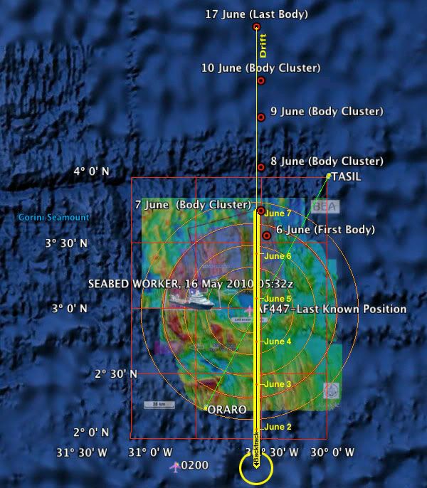
The Google Earth KMZ file has been updated here.
So for about four days, June 7 through June 10, we DO know what the current was doing at a pretty steady pace: about 20nm per day due northward (with a tiny bit of westing). So heuristics (a rule of thumb nicked slightly by Occam's Razor) might cause us to ask "What would be significantly different during the preceeding six days in that patch of ocean," and point us to an ultra simple linear solution for the initial six days of drift: about 20nm per day x six days = 120 nautical miles, backtracked almost due southward from the June 7 body cluster.
This solution is waaay outside of BEA's "40nm from last known position" search radius and its "lawn mowing" and occasional Phase Three diversions. Understandably, there are tricky currents in those equitorial waters, as the BEA Report clarifies:
But nobody was there to actually measure the set and drift in that part of the ocean and verify the computer models, checking the probable variations within that hundred or so mile radius patch of interest. We do know for a fact, however, that on days six, seven, eight, and nine the cluster of bodies was setting almost exactly northward, drifting at somewhat less than a knot, with windage and wind direction playing a minor, if not negligible, role (particularly in comparison to the VS and the Crew Rest compartment). Perhaps I am missing something here, like charted and known counter currents and swirls, surface storms, or other variables in this area occurring between June 1 and June 6... In any case, sometimes computer models can become overly complicated.
There are so many unknowns!
As Phase Three of the search effort concludes, some very hard and possibly expensive decisions will be made.
GB
By way of revisiting the thinking:
2 July, 2009 BEA Findings
At this stage of the investigation, the following facts have been established:
� the first bodies and airplane parts were found on 6 June,
� the elements identified came from all areas of the airplane,
� visual examination showed that the airplane was not destroyed in flight ; it appears to have struck the surface of the sea in a straight line with high vertical acceleration.
� the first bodies and airplane parts were found on 6 June,
� the elements identified came from all areas of the airplane,
� visual examination showed that the airplane was not destroyed in flight ; it appears to have struck the surface of the sea in a straight line with high vertical acceleration.
Appendix 4 of the 1st Interim Report is a graphical interpretation of the 640 found item database. While these BEA graphics lack granularity or information detail, it is visually apparent that the majority of bodies were discovered in fairly well-grouped clusters on June 7, 8, 9, and 10. It makes sense that the bodies would be clustered: unlike various aircraft parts and high-floating debris, they share similar properties of form and would respond similarly to local current, wind, and sea conditions.
Likely, the dispersion and separation within this once tightly-grouped cluster increased to perhaps several square miles or more over six or seven days. So search and recovery needed to cover a large area each day, even when the general location of the cluster was identified. Each day, according the the BEA graphics in Appendix A, the cluster drifted almost due northward in a straight line along the 30�30'W meridian, about twenty nautical miles per day:
June 7: 3� 45'
June 8: 4� 05'
June 9: 4� 28'
June 10: 4� 45'
The Google Earth KMZ file has been updated here.
So for about four days, June 7 through June 10, we DO know what the current was doing at a pretty steady pace: about 20nm per day due northward (with a tiny bit of westing). So heuristics (a rule of thumb nicked slightly by Occam's Razor) might cause us to ask "What would be significantly different during the preceeding six days in that patch of ocean," and point us to an ultra simple linear solution for the initial six days of drift: about 20nm per day x six days = 120 nautical miles, backtracked almost due southward from the June 7 body cluster.
This solution is waaay outside of BEA's "40nm from last known position" search radius and its "lawn mowing" and occasional Phase Three diversions. Understandably, there are tricky currents in those equitorial waters, as the BEA Report clarifies:
The proximity to the equator affects the modelling of the currents in the estimated accident zone. The lack of available on-the-spot data and the complex oceanic dynamic (notably due to the seasonal start of the northequatorial counter-current during the month of June) also make it difficult to model the marine currents. These factors contributed to making the reverse drift calculations imprecise, added to which it was necessary to make them over a period of five to six days, which accentuated the gaps.
There are so many unknowns!
As Phase Three of the search effort concludes, some very hard and possibly expensive decisions will be made.
GB
Last edited by GreatBear; 24th May 2010 at 22:57. Reason: Credit to Takata and mm43; thanks to sensor_validation; fix body count
Joined: Jul 2009
Posts: 134
Likes: 0
From: UK
I have seen reference that the Brazilian Navy dropped marker buoys very early in search, so some real surface drift should be known.
The expected currents were in this post, which partly explains the search area
mm43's post
But your suggestion is remarkably similar to that suggested a long time ago - do check the date posted
takata's post
I wonder if it is now possible to map where the wreckage is not - the original visual search will have oveflown the expected flight path etc...
Joined: May 2010
Posts: 1,569
Likes: 373
From: PLanet Earth
Ghostbear,
interesting and reasonable analysis.
I'm wondering anyway why not more seems to have been published by BEA on drift patterns.
Moreover also the Search patterns seem to ignore them largely.
given the trend between 6th and 17th of June, why would anyone perform a detailed search north or even at the poistion of the debris / bodies of June 6th.
From my (very amateur) perspective starting around the location identified by mm43 and then going e.g. in concentric circles would have increased the likelihood of finding something significantly. At least much more likely then around the location of the bodies found on June 6th. And I guess most people around here would agree.
So many experts and big dollars being involved I'm a bit uncertain what us mortals are missing?
Joined: Jan 2008
Posts: 2,173
Likes: 51
From: Blighty (Nth. Downs)
40 nm RADIUS FROM LKP − IS IT ENOUGH?
GreatBear suggests above that the crash might have been outside the 40nm radius from LKP (last-known position), on the basis of back-tracking of body-drift. In response to takata�s comparable �Probable Crash Zone�, posted here on 21st June 2009, FlexibleResponse stated here that �you also need to take into account that the human body does not float in seawater until about 72 hours after death. Then there should be some allowance for the time from establishing positive buoyancy to float from the wreckage at the bottom of the ocean up to the surface. Again some allowance should be made for the average sea current during the ascent time�� (etc.)
Not sure if FlexibleResponse�s assertion has been challenged since but, if not, it put the crash zone back into the circle of 40nm radius. So what about the limited evidence we have of possible flight-paths after LKP, based on evidence of ACARS messages and BEA analysis of aircraft debris?
At risk of re-hashing previous discussions, the implications of the BEA Tests and Research into ACARS messages (Para 1.16 of Interim Reports 1 & 2), as I interpret them, include the following:
02:10:10z (�AP-OFF� message received from ACARS) indicates aircraft at, or close to, planned cruise F350/M0.82, GS<480kt;
02:10:34z (routinely received from ACARS) LKP − FL and GS unconfirmed (?);
02:14:45z (inferred from absence of receipt of an expected ACARS transmission) − flight has ended;
aircraft was intact until impact at sea-level, and impact GS (not stated) unremarkable, so probably below 300kt.
So one may infer that the aeroplane descended 35,000ft in not more than 4min35sec, starting with a GS of, say, 480kt (8nm/min). In addition, it had to reduce GS to something below 5nm/min prior to impact.
This suggests a rate of descent averaging 7600ft/min. That is nearly three times the average VS obtained at normal descent speeds (prior to deceleration) with idle thrust, yet TAS seems to have been considerably lower at impact than at start of descent. Where did the drag come from; to dissipate so much potential energy, and some kinetic energy, so quickly? Spoilers/speed-brakes are unlikely to have been used, and there is no evidence that the L/G was ever extended.
[If the ADR used by the A/THR was grossly under-reading the IAS/IMN, thrust above idle may have been maintained − despite descent − until 02:10:47z (ACARS �A-THR OFF� message received), or even later if the throttles were left open at that point (thrust lock).]
There�s been speculation that the loss of FPV (02:12:10/16) would have been caused by TAS>599kt (10nm/min), although this datum would be from an ADR that had been delivering under-readings of IAS previously. If the relevant pitot had thawed out in 2min, for reasons unclear, excessive TAS remains a possible cause; although the �measured CAS lower than 60kt� may be more consistent with the likely scenario of a blocked pitot tube, coupled with rising static pressure (in the descent) from unfrozen static ports. The third possible cause of the FPV being disallowed, VS>20,000ft/min, is implausible on an intact aeroplane − unless previously frozen static ports were unblocking.
Overspeed - A/C Intact
Although it is possible that the aircraft stalled at high altitude, it seems unlikely with airspeed indications under-reading. Overspeed is more probable, particularly early-on. From the BEA�s comments on condition of the control surfaces recovered, this would not have been supersonic, so that limits average descent TAS to about 600kt (10nm/min). ** In this scenario, with a clean aeroplane, the speed reduction from over 600kt to 300kt − albeit achieved during a shallow descent − would have taken nearer two minutes than one, I suggest. That reduces the average TAS to a figure well below 10nm/min, and an average GS of a similar order. The alternative deceleration scenario of flare into a steep climb, followed by deep stall, would lower the average TAS further, presumably.
(Note: all this is predicated on absence of in-flight structural failure, and an impact time not later than 02:14:45z.)
Ignoring the unpredictable wind components, which are not likely to have amounted to much overall, it therefore seems unlikely that the aircraft would have travelled more than 40nm in the 4:11 after LKP, i.e., averaged a GS of more than 574kt (9.56nm/min). And, even if it could, is it likely to have travelled in one straight line, i.e., continuing north-eastwards along the airway?
Given the above, and inferring from the evidence that flight beyond 02:14:45z was unlikely, the 40nm radius of search from the LKP (last-known position) seems to suffice.
Chris
** If the descent stabilised at, say, M0.95, the IAS/CAS would rise rapidly through VMO; the TAS rising at a much lower rate. Considering the BEA has not reported tell-tale signs of extreme dynamic pressure to the tail fin (V/S) and flying controls retrieved so far, one must assume that the descent TAS at lower altitudes would have been considerably lower than 600kt. No doubt, various computer models will have been run by the BEA, not to mention trials on flight simulators.
Last edited by Chris Scott; 24th May 2010 at 13:34. Reason: Para 5 reference to IAS/CAS changed to TAS.
Joined: Jun 2009
Posts: 1,330
Likes: 0
From: NNW of Antipodes
Update: "Seabed Worker" - position
An apology for the positions last posted. It transpires there were transcription errors in the positions, and the "Seabed Worker" didn't go out to the west of the current search zone. That post has now been removed, and the correct positions over the last two days follow:-
23 May 2010 16:20 Hdg 276.5 Spd 00.6 3�05'42"N 30�45'08"W
23 May 2010 07:11 Hdg 255.9 Spd 00.8 3�04'59"N 30�41'40"W
23 May 2010 05:30 Hdg 101.1 Spd 10.3 3�06'41"N 30�49'52"W
23 May 2010 03:45 Hdg 303.9 Spd 01.0 3�10'42"N 30�49'13"W
22 May 2010 19:00 Hdg 082.3 Spd 07.2 3�28'58"N 30�34'25"W
22 May 2010 17:09 Hdg 024.5 Spd 10.3 3�21'09"N 30�40'13"W
22 May 2010 06:34 Hdg 261.7 Spd 00.4 3�07'10"N 30�41'35"W
21 May 2010 18:18 Hdg 323.5 Spd 00.8 3�07'16"N 30�41'11"W

It would seem that the vessel has been and had a look at some areas to the north previously covered by the "Anne Candies" with her towed sidescan sonar. Currently, she is back in an area around 10NM northwest of the LKP.
mm43
23 May 2010 16:20 Hdg 276.5 Spd 00.6 3�05'42"N 30�45'08"W
23 May 2010 07:11 Hdg 255.9 Spd 00.8 3�04'59"N 30�41'40"W
23 May 2010 05:30 Hdg 101.1 Spd 10.3 3�06'41"N 30�49'52"W
23 May 2010 03:45 Hdg 303.9 Spd 01.0 3�10'42"N 30�49'13"W
22 May 2010 19:00 Hdg 082.3 Spd 07.2 3�28'58"N 30�34'25"W
22 May 2010 17:09 Hdg 024.5 Spd 10.3 3�21'09"N 30�40'13"W
22 May 2010 06:34 Hdg 261.7 Spd 00.4 3�07'10"N 30�41'35"W
21 May 2010 18:18 Hdg 323.5 Spd 00.8 3�07'16"N 30�41'11"W
It would seem that the vessel has been and had a look at some areas to the north previously covered by the "Anne Candies" with her towed sidescan sonar. Currently, she is back in an area around 10NM northwest of the LKP.
mm43

Joined: Mar 2001
Posts: 694
Likes: 0
From: us
The search grids, June 1 through June 5

The search grid on June 6, when the first wreckage and bodies from the plane were spotted.

Unfortunately, in retrospect, the searches June1-5 concentrated on areas to the right of the track, and south of the last reported position.
In the June 1-5 image, the June 1 search grid was the narrow rectangular box from the last reported position almost to Tasil. The June 2nd search grids were mainly the two rectangular boxes, almost perpendicular to the June 1 search box, and to the right of the track.
I believe the circle in the June 6 image was not a search grid. but only an indicator of the distance from the last reported position and the debris sightings.
The search grid on June 6, when the first wreckage and bodies from the plane were spotted.
Unfortunately, in retrospect, the searches June1-5 concentrated on areas to the right of the track, and south of the last reported position.
In the June 1-5 image, the June 1 search grid was the narrow rectangular box from the last reported position almost to Tasil. The June 2nd search grids were mainly the two rectangular boxes, almost perpendicular to the June 1 search box, and to the right of the track.
I believe the circle in the June 6 image was not a search grid. but only an indicator of the distance from the last reported position and the debris sightings.
Joined: Jun 2009
Posts: 1,330
Likes: 0
From: NNW of Antipodes
Where to now?
At this juncture it is important to look carefully at the proposals put forward by Great Bear, takata and also observations made by Chris Scott, sensor_validation and others, because each submission has a point or two that could add to the understanding of "where?".
From my own perspective, I have possibly become blinkered through making use of the OSCAR and QuikSCAT satellite data and trying to make it fit a solution. sensor_validation pointed out an early post of mine which attempted to make sense of the ocean current circulation at the time of the crash. What it does indicate, is that the aircraft crashed in a fickle part of the equatorial North Atlantic, and that available current data can not be relied upon explicitly. Some other factors, notably drifter buoy data from the surrounding area, once again tend to confuse the issues.
Getting back to the initial airborne searches conducted by the Brazilian Air Force (FAB); they also need to be carefully considered, though on a couple of days the cloud base was relatively low and visibility marginal. It could be that the debris was overflown, but one wonders on the lack of any radar targets. Composites don't make good targets, and neither do spoilers etc. floating flush with the surface. So the lower the altitude flown during a radar search, the less chance you have of getting meaningful returns - other than sea clutter. The following is a screen shot taken in the Rescue Coordination Center at Recife showing areas that have been searched by the FAB, and from it you will note the limited area to the west of the LKP that was covered.

Later screen shots [not shown here] show an extensive grid search undertaken once the initial debris was sighted.
In short, where we are now provides a very good and expensive analysis of where the aircraft didn't crash, and a rethink and further examination of the available data is a "must" before further funds are committed to another search.
mm43
From my own perspective, I have possibly become blinkered through making use of the OSCAR and QuikSCAT satellite data and trying to make it fit a solution. sensor_validation pointed out an early post of mine which attempted to make sense of the ocean current circulation at the time of the crash. What it does indicate, is that the aircraft crashed in a fickle part of the equatorial North Atlantic, and that available current data can not be relied upon explicitly. Some other factors, notably drifter buoy data from the surrounding area, once again tend to confuse the issues.
Getting back to the initial airborne searches conducted by the Brazilian Air Force (FAB); they also need to be carefully considered, though on a couple of days the cloud base was relatively low and visibility marginal. It could be that the debris was overflown, but one wonders on the lack of any radar targets. Composites don't make good targets, and neither do spoilers etc. floating flush with the surface. So the lower the altitude flown during a radar search, the less chance you have of getting meaningful returns - other than sea clutter. The following is a screen shot taken in the Rescue Coordination Center at Recife showing areas that have been searched by the FAB, and from it you will note the limited area to the west of the LKP that was covered.
Later screen shots [not shown here] show an extensive grid search undertaken once the initial debris was sighted.
In short, where we are now provides a very good and expensive analysis of where the aircraft didn't crash, and a rethink and further examination of the available data is a "must" before further funds are committed to another search.
mm43
Last edited by mm43; 24th May 2010 at 02:16.
Joined: May 2010
Posts: 126
Likes: 0
From: MA, USA
Based on mm43's positions in post: http://www.pprune.org/5710975-post1125.html, I am puzzled by the northern excursion on 5/22. Based on the times of the preceding and trailing positions at the south westerly search area, they spent less than 20hours at the northern site, possibly much less. One of those positions is on the eastern edge of search zone 2 of BEA's 5/4 extended search areas. <20hrs is not sufficient time to deploy transponders, launch and recover the AUVs and recover the transponders, and also have any useful bottom time. Zone 2 is 16 x 3.5km and would take about 16-18 hours to search using both AUVs, based on the search rate I proposed in post: http://www.pprune.org/5692187-post1029.html. Note that at both these positions, Seabed Worker was travelling at a transit speed, and was not loitering. I wonder what that excursion was for.
I find it interesting that on 5/23 Seabed worker appears to have started a new search area, as noted by mm43. I thought they were due in port at either Recife or the Cape Verde Is. on 5/25, and would have had to leave the area no later than the evening of 5/22 to make either transit, assuming a 12 knot cruise speed (http://www.seabedgroup.no/attachment...WORKER-007.pdf).
Edit: I re-read the BEA announcement of 5/4, and it says "The search operations in the zone will be completed around 25 May." So I guess the 5/25 date is for the end of the search, not the arrival in port. Sorry for the noise.
Last edited by auv-ee; 24th May 2010 at 02:43. Reason: Typos and review of the 5/25 date.
Joined: Jun 2009
Posts: 1,330
Likes: 0
From: NNW of Antipodes
originally posted by auv-ee ...
... the BEA announcement of 5/4 ... says "The search operations in the zone will be completed around 25 May."
... the BEA announcement of 5/4 ... says "The search operations in the zone will be completed around 25 May."
mm43
Joined: May 2004
Posts: 704
Likes: 0
From: Melbourne
AF447 dead treated like a footnote by Air France
Ben Sandilands, Australian aviation journalist and blogger reports: AF447 dead treated like a footnote by Air France.
Joined: Jun 2009
Posts: 244
Likes: 0
From: in a plasma cocoon
HN39, waiting the FCOM value of V-alpha-max, Vs1G~M 0.56 (at FL350, with 0� roll, M~205t and clean config) and as a rule of thumb, Vstall~0.93 Vs1G~M 0.52. But you are interested by the value of Vstall at sea level ? (secondary stall/overcorrection at low altitude in the absence of alpha prot ?).
Back to the search area,
-the initial visual searches (SaturnV reminder): if no debris or body was found during the 5 days after the accident, it is probable that the search means were not deployed on the right spot: if most of the initial searches were dedicated to the south and the east of the LKP without any results, it suggests that the debris/bodies were initially located to the north or west of the LKP, away from the AF 447 expected route.
From the debris/bodies time distribution and back drifting analysis: there are two groups of results, one from the Meteo France (Mercator model) which suggests that the debris/bodies were drifting with the north equatorial currents (oriented to the NE at 2� north and to the NW at 4� north) and a group of results from the US Navy, the USCG and the Brazilian Navy (using the same NCOM currents model) suggesting that the debris were initially under the influence of the north equatorial counter currents or combined influences of the two currents (north at 3�N, rotating to the NE at 4�N). The latest recovered debris drift clearly showed a NW rotation of the currents, consistent with north equatorial currents: it would suggest a back drifted estimate closer to the Meteo France or MM43 estimates, largely (between 25NM and 40 NM) to the west of the LKP (see the MM43 analysis from NOAA/OSCAR current maps).
-the one month pinger searches: suggest that the underwater beacon locators (assuming at least one of the UBL was still functionning) are not to be found to the north of LKP (explored using TPL with a good confidence level). But the French Navy helped by Thales (pingers waveform detection) suggests that the UBL could be located in the south-west area of the 40 NM radius circle, little bit (10-20 NM) south of MF/MM43 estimates.
-from the areas already searched using the sidescan sonars during the phase 3 without success (mainly NW of the LKP) and the above considerations, the W-SW areas of the 40 NM radius circle seems by far the best candidate now for further searches and I really hope that a new search phase will be funded for this SW area.
Jeff
Last edited by Hyperveloce; 24th May 2010 at 14:37. Reason: rephrasing a cryptic sentence about backdrifted estimates
Joined: Jun 2009
Posts: 57
Likes: 0
From: Chesapeake Bay
Chris Scott: Thank you for your analysis. Descent of the aircraft from normal cruise at FL350 to sea level in less than four and a half minutes presents a nightmare of darkness, bad weather, unusual attitudes and perhaps overwhelming g forces. As you point out, the timing between 02:10:47z and the unreceived 02:14:45z ACARS messages "suggests a rate of descent averaging 7600ft/min. That is nearly three times the average VS obtained at normal descent speeds (prior to deceleration) with idle thrust..."
So many unknowns. Might the aircraft have been still in the air beyond 02:14:45z (asymetrical flame-outs -- loss of power)? Uncontrolled, would this 205t aircraft "drop like a stone?" Had the crew already turned back (they were west of track at 02:10)? Many questions already discussed in this and the prior thread. Few hard answers.
But all might agree now with Hyperveloce that "the SW of the 40 NM radius circle seems by far the best candidate now for further searches and I really hope that a new search phase will be funded for this SW area."
While there have been beneficial lessons already learned from this tragedy, it seems there will be no definition without more data. Mow the lawn! Readable black boxes are the holy grail.
As we approach the first anniversary, my thoughts are with the many relatives and loved ones who have lost so much.
GB
Guest
Posts: n/a
Had it not been determined that 447 was tracking left? Also at least a few had proposed that she had made a (complete?) turn? Had the uA/S wacked the panel sufficient to dispose a turn back? If that is not the case (apparently) the virginal ocean bottom W(NW) of LKP doesn't deserve a look, but if otherwise?
mm43, Hazelnuts, Hyperveloce, etc., you are to be commended for your persistence and scholarly work. There is no corporate agenda that holds a small candle to the need for blazing light on this operation, for the good of all.
mm43, Hazelnuts, Hyperveloce, etc., you are to be commended for your persistence and scholarly work. There is no corporate agenda that holds a small candle to the need for blazing light on this operation, for the good of all.
Joined: Jul 2009
Posts: 1,682
Likes: 0
From: France - mostly
Originally Posted by Chris Scott
Considering the BEA has not reported tell-tale signs of extreme dynamic pressure to the tail fin (V/S) and flying controls retrieved so far, one must assume that the descent TAS at lower altitudes would have been considerably lower than 600kt.
what 'tell-tale signs' do you have in mind?
HN39
Guest
Posts: n/a
Please excuse the interruption.Will Fraser and others immediately brought up LOC and loss of airframe integrity. The hasty First Report was worded such that these possibilities were impossible; "En Ligne de Vol", "Intact at impact" etc. BEA has assumed from the outset an adversarial and defensive posture, imo, one that attempts to undermine even a glance at another "conclusion" than "Not enough A/S for level flight, but 'oh so close'".
The aircraft is defended in a sly way, since the "conclusions" are premature, openly invite disagreement, (with evidence), and properly belong in the Final.
rgards, bear
The aircraft is defended in a sly way, since the "conclusions" are premature, openly invite disagreement, (with evidence), and properly belong in the Final.
rgards, bear
Joined: Apr 2007
Posts: 103
Likes: 0
From: in the shed
"intact at impact" you could say that of the recent puzzel at tripoli, definately intact, but a nanosecond later and most of it you put in your pockets
perhaps thats why they cant find anything, the bits are just to small.
gs
perhaps thats why they cant find anything, the bits are just to small.
gs
Guest
Posts: n/a
Ah yes, the bodies. On the one hand, there are 43 which exhibit injury consistent with seated and vertical acceleration. But wait, werent there 53 bodies recovered? What of the others? Uninjured? Or was their injury inventory inconsistent with the determination of BEA's that there was no loss of Hull integrity at altitude? No matter, even though the list of 43 victims offered "support" to BEA's "conclusion" it is on the surface only. A human ejected into the slipstream of an airliner's at cruise would exhibit these specifics almost certainly. So there is no academic value to BEA's assertion. What then? If it proves nothing, why include these, exclude the other results, and 'conclude' anything at all? Unfortunately, most of the readers who have ingested the BEA reports, assume BEA is correct. They could be. But it is in no way certain, just as any conclusion would be, gelled prior to conclusive evidence.
BEA, Air France, and ABI all have a monstrous stake in the findings, here, and the findings needn't be accurate, they need only be believed. So, what do we have? A sales job. Not even a good one. No matter. In their shoes, I would be claiming all the same "conclusions".
BEA, Air France, and ABI all have a monstrous stake in the findings, here, and the findings needn't be accurate, they need only be believed. So, what do we have? A sales job. Not even a good one. No matter. In their shoes, I would be claiming all the same "conclusions".