Three weeks after the accident, Takata
plotted the reported position of recovered items and concluded: "...even if the drift was actually half my figure (it may also be twice), AFF 447 would have turned back and not crashed close to 2014Z." In December, 2009, mm43 charted the
expected influences of the North Brazil Current, the North Atlantic Equatorial Current, and the North Atlantic Equatorial Counter Current and noted the conclusions of M�t�o-France, SHOM, IFREMER, Mercator Ocean, CROSS Gris-Nez, the U.S. Navy, Brazilian Navy and U.S. Coast Guard (USCG) as well as his own. A lot of talent has been focused on determining where to search for the hull. A lot of seabed has already been covered testing many hypotheses. So far, no joy.
By way of revisiting the thinking:
2 July, 2009
BEA Findings
At this stage of the investigation, the following facts have been established:
� the first bodies and airplane parts were found on 6 June,
� the elements identified came from all areas of the airplane,
� visual examination showed that the airplane was not destroyed in flight ; it appears to have struck the surface of the sea in a straight line with high vertical acceleration.
If the A/C impacted the water intact in a straight line with high vertical acceleration (stated as a fact by BEA), then breakup of the fuselage and ejection of debris occured at that moment, meaning that on the morning of June 1st, debris and bodies were colocated in a small area, likely less than a kilometer in diameter. Destruction was so complete that wreckage and bodies from all parts of the A/C interior, fore to aft, were later found. For the following six days, until first discovery of wreckage and subsequent recovery, each item drifted in a way determined by its windage, buoyancy and the environment. According to BEA's 1st Interim Report, a database of 640 discovered items was built, which included the date/time recovered and lat/long. Later, in the
2nd Interim report, that database was described as containing about 1000 wreckage items (not including some 50 identified bodies).
Appendix 4 of the
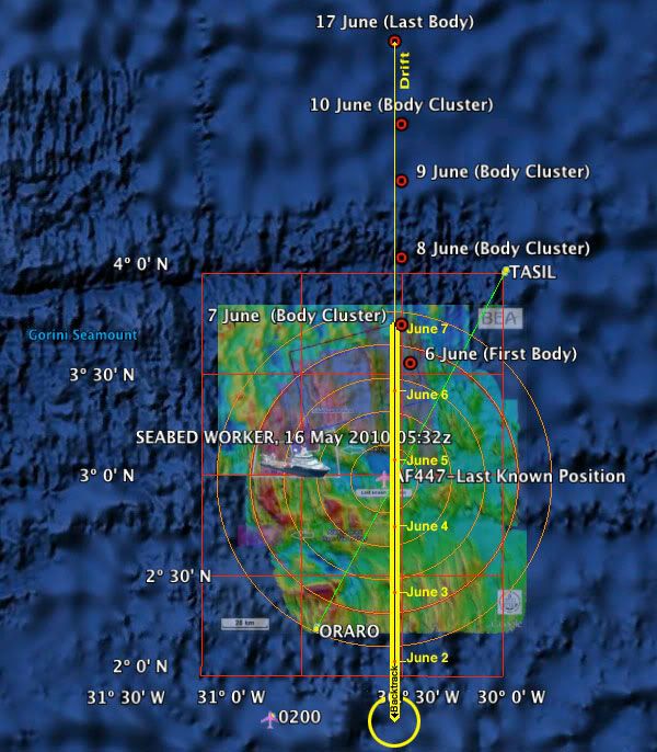
1st Interim Report is a graphical interpretation of the 640 found item database. While these BEA graphics lack granularity or information detail, it is visually apparent that the majority of bodies were discovered in fairly well-grouped clusters on June 7, 8, 9, and 10. It makes sense that the bodies would be clustered: unlike various aircraft parts and high-floating debris, they share similar properties of form and would respond similarly to local current, wind, and sea conditions.
Likely, the dispersion and separation within this once tightly-grouped cluster increased to perhaps several square miles or more over six or seven days. So search and recovery needed to cover a large area each day, even when the general location of the cluster was identified. Each day, according the the BEA graphics in Appendix A, the cluster drifted almost due northward in a straight line along the 30�30'W meridian, about twenty nautical miles per day:
June 7: 3� 45'
June 8: 4� 05'
June 9: 4� 28'
June 10: 4� 45'
The Google Earth KMZ file has been updated
here.
So for about four days, June 7 through June 10, we DO know what the current was doing at a pretty steady pace: about 20nm per day due northward (with a tiny bit of westing). So heuristics (a rule of thumb nicked slightly by Occam's Razor) might cause us to ask "What would be significantly different during the preceeding six days in that patch of ocean," and point us to an ultra simple linear solution for the initial six days of drift: about 20nm per day x six days = 120 nautical miles, backtracked almost due southward from the June 7 body cluster.
This solution is waaay outside of BEA's "40nm from last known position" search radius and its "lawn mowing" and occasional Phase Three diversions. Understandably, there are tricky currents in those equitorial waters, as the BEA Report clarifies:
The proximity to the equator affects the modelling of the currents in the estimated accident zone. The lack of available on-the-spot data and the complex oceanic dynamic (notably due to the seasonal start of the northequatorial counter-current during the month of June) also make it difficult to model the marine currents. These factors contributed to making the reverse drift calculations imprecise, added to which it was necessary to make them over a period of five to six days, which accentuated the gaps.
But nobody was there to actually measure the set and drift in that part of the ocean and verify the computer models, checking the probable variations within that hundred or so mile radius patch of interest. We do know for a fact, however, that on days six, seven, eight, and nine the cluster of bodies was setting almost exactly northward, drifting at somewhat less than a knot, with windage and wind direction playing a minor, if not negligible, role (particularly in comparison to the VS and the Crew Rest compartment). Perhaps I am missing something here, like charted and known counter currents and swirls, surface storms, or other variables in this area occurring between June 1 and June 6... In any case, sometimes computer models can become overly complicated.
There are so many unknowns!
As Phase Three of the search effort concludes, some very hard and possibly expensive decisions will be made.
GB