


Malaysian Airlines MH370 contact lost

Join Date: Jan 2008
Location: s wales
Age: 81
Posts: 9
Likes: 0
Received 0 Likes
on
0 Posts
Link from Roving's post above.
I reckon if this is the wreckage it probably went into the water around the "km" of 387km, .
Earlier in the week there was a post showing the prevailing currents and that would have taken the wreckage from my assumed crash point to the location area
I reckon if this is the wreckage it probably went into the water around the "km" of 387km, .
Earlier in the week there was a post showing the prevailing currents and that would have taken the wreckage from my assumed crash point to the location area

Join Date: May 2012
Location: Australia
Posts: 131
Likes: 0
Received 0 Likes
on
0 Posts
Link from Roving's post above.
I reckon if this is the wreckage it probably went into the water around the "km" of 387km, .
Earlier in the week there was a post showing the prevailing currents and that would have taken the wreckage from my assumed crash point to the location area
I reckon if this is the wreckage it probably went into the water around the "km" of 387km, .
Earlier in the week there was a post showing the prevailing currents and that would have taken the wreckage from my assumed crash point to the location area
Yes I Agree but perhaps a little higher as the oil rig sighting was 265-275 (270 is direct west)
Last edited by StormyKnight; 13th Mar 2014 at 02:09.
At 387 km from Chinese satellite image to oil rig a problem arises:
An object at 35,000' would be below the horizon of the observer on the rig.
An object at 35,000' would be below the horizon of the observer on the rig.
Join Date: Dec 2005
Location: Leeds
Posts: 702
Likes: 0
Received 0 Likes
on
0 Posts
Isn't there a relatively simple process of deduction re: the possible primary radar sighting of an aircraft over the Malacca Strait, I.e. if it wasn't MH370, then what aircraft was it? That issue is a sub-story in itself.
If it was another aircraft with a low radar sig, did it play a part in the demise of MH370, either intentionally or unintentionally? Did one plane limp off west and the other limp off east? Was it fast moving from east to west and collided with MH370?
Are the Malaysians behaving like they're under duress from another nation (China or the US) with regards to what they're comfortable saying publicly about what actually happened?
It's just another theory, but speculation will continue 'til some hard facts emerge.

Join Date: Feb 2011
Location: Leeds
Posts: 1
Likes: 0
Received 0 Likes
on
0 Posts
I wonder what uncle sam is thinking now that they know that the chinese have these kinds of imaging capabilities.
I am pretty sure the americans are fully aware of Chinese satellite capabilities
These pieces look too big to be wreckage of a 777, but what the hell else could it be, its promising but i am fully expecting to be "let down" again
Join Date: May 2011
Location: U.S.
Posts: 84
Likes: 0
Received 0 Likes
on
0 Posts
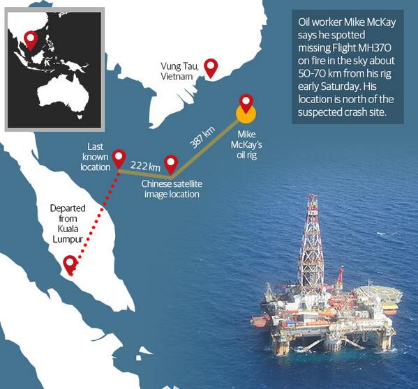
Re: StormyKnight and Mike McKay
Thanks Stormy Knight for putting up that graphic.
This is very much as Mike McKay described his observation in the email.
From his description the course was maybe not so direct from last known location. Maybe the plane paralleled the coast (consistent with two sets of eyewitness/earwitness reports) then turned more NE.
His email described the burning plane as coming toward him (or away) on a heading somewhat crossing the normal flight paths and contrails. I believe he even guessed the angle from his rig.
This is sadly fitting together.
If it was another aircraft ... did it play a part in the demise of MH370 ... Did one plane limp off west and the other limp off east?
Join Date: May 2012
Location: Australia
Posts: 131
Likes: 0
Received 0 Likes
on
0 Posts
Thanks Stormy Knight for putting up that graphic.
This is very much as Mike McKay described his observation in the email.
From his description the course was maybe not so direct from last known location. Maybe the plane paralleled the coast (consistent with two sets of eyewitness/earwitness reports) then turned more NE.
His email described the burning plane as coming toward him (or away) on a heading somewhat crossing the normal flight paths and contrails. I believe he even guessed the angle from his rig.
This is sadly fitting together.
This is very much as Mike McKay described his observation in the email.
From his description the course was maybe not so direct from last known location. Maybe the plane paralleled the coast (consistent with two sets of eyewitness/earwitness reports) then turned more NE.
His email described the burning plane as coming toward him (or away) on a heading somewhat crossing the normal flight paths and contrails. I believe he even guessed the angle from his rig.
This is sadly fitting together.
Join Date: Sep 2009
Location: over the rainbow
Age: 75
Posts: 562
Likes: 0
Received 0 Likes
on
0 Posts
Although there has been much criticism of Malaysia's planning and coordination of the SAR, the planning is only as good as its execution and this Reuter's note suggests that whatever the Satellite images are, it was the Vietnamese who searched that grid reference. That is not surprising given it is within its territorial waters.
PHU QUOC ISLAND: Vietnam has already searched the area where Chinese satellites showed objects that could be debris from the missing Malaysia Airlines (MAS) flight MH370 but a plane has been sent to check the area again, Vietnamese military officials said.
�We are aware and we sent planes to cover that area over the past three days," Deputy Transport Minister Pham Quy Tieu told Reuters. �Today a (military) plane will search the area again,� he said.
Another military official said Vietnam was waiting to see photographs taken by a Chinese satellite on Sunday in waters northeast of Kuala Lumpur and south of Vietnam in order to identify the exact location for further inspection. � Reuters
Gentlemen: a serious question from a rotary pilot which may have an obvious answer that as yet escapes me:
In an emergency descent in reaction to an explosive (or other) decompression, what is the rationale for a major heading change?
This is one scenario I don't often find myself having to consider.
In an emergency descent in reaction to an explosive (or other) decompression, what is the rationale for a major heading change?
This is one scenario I don't often find myself having to consider.
Join Date: Feb 2008
Location: Earth
Posts: 101
Likes: 0
Received 0 Likes
on
0 Posts
Why would China release photos but do nothing? Surely they would want to be first on the scene to prove how capable their Navy is and because the majority of passengers were from China.
Join Date: Jun 2008
Location: Ventura, California
Age: 65
Posts: 262
Likes: 0
Received 0 Likes
on
0 Posts
Dimensions.
I'm not buying the reported dimensions of the objects in the Chinese images as gospel, unless someone can explain specifically how they were derived. Given that uncertainty, all this imagery analysis on the news is baloney.
It seems as though the Media wants to keep the uncertainty going. Very shorty, surface and air assets will be on location, and we'll know; but I'll bet a nickel the Chinese have found it.
It seems as though the Media wants to keep the uncertainty going. Very shorty, surface and air assets will be on location, and we'll know; but I'll bet a nickel the Chinese have found it.
Join Date: Nov 2004
Location: Perth - Western Australia
Age: 75
Posts: 1,805
Likes: 0
Received 0 Likes
on
0 Posts
ABC News (Aust) states - "China said the objects were spread across an area with a radius of 20 kilometres, in sizes that appeared to be 13 x 18 metres, 14 x 19m, and 24 x 22m."
If the fuselage and wings opened out on impact, this would explain the large sizes of the items sighted. Those sizes eliminate sea containers.
Items were stated to be "floating", possibly just below the surface? Light refraction under the water could account for variances in size estimation.
If the fuselage and wings opened out on impact, this would explain the large sizes of the items sighted. Those sizes eliminate sea containers.
Items were stated to be "floating", possibly just below the surface? Light refraction under the water could account for variances in size estimation.
Join Date: Jul 2013
Location: Las Vegas NV.
Age: 63
Posts: 165
Likes: 0
Received 0 Likes
on
0 Posts
Just watched the latest update on an US cable network... Honestly, some of the silliest posts on this board that the mods have deleted bear more weight than the crud they are dispensing
BTW: several posters have commented that they are required to switch the transponder from TA/RA to TA In the event of a depressurization.
There is a damn good reason to do this. If another aircraft is in your flight path as you hit the deck, and you are both in TA/RA the TCAS solution might be to have you climb ( not likely you're gonna do that ) and the other aircraft descend. IMHO, this is adding to the workload in an emergency, and I can't think of a reason a cabin baro switch couldn't do this for you...
Once we figure what happened, I DO think we as the aviation family need to kick some ideas around. Any step we can eliminate in an emergency procedure allows more time for the drivers to fly.
Join Date: Sep 2009
Location: Seattle, USA
Age: 57
Posts: 27
Likes: 0
Received 0 Likes
on
0 Posts
I'm not buying the reported dimensions of the objects in the Chinese images as gospel, unless someone can explain specifically how they were derived.
Join Date: Sep 2006
Location: ex Ice Station Kilo
Age: 66
Posts: 21
Likes: 0
Received 0 Likes
on
0 Posts
Stanley11:
China Flyer:
Aircrew react well to Standard Operating Procedures. Unfortunately, the challenge illustrated in the above quotes reveals a great difficulty that can arise when a maxim becomes a dictum! If you chant it, and act on it as though it was a liturgy, you can come unstuck. We live in a world where cosy soundbites rule. Alas this can all too easily undo the good that was intended by the snappy "Aviate, Navigate, Communicate" maxim.
Sure, there are three separate actions. Whilst I cannot conceive of removing AVIATE from top priority, if the motor skills you have acquired through experience prevent you from flying the aircraft AND paying heed to one or other of the remaining tasks, you must consider that you need help. Communicating this need would be good at this point in the proceedings. SHOVE the navigation task onto someone else: like ATC?
The terrain you are over might also make an early call for help desirable.
In an aircraft that has two pilots, two people sharing three tasks is easier than one person. Of course, if one of you has become incapacitated, then calling for help early takes much pressure off you!
Aviate, navigate, communicate ought to be viewed as a collection of requirements and not a by numbers drill.
There are two ways of problem solving: intellectually or procedurally.
An intellectual approach allows EVERY problem to be novel and brings a pilot's primary and background knowledge plus experience to bear to come up with a solution. All well and good.
Unfortunately, no two people will resolve a given problem in the same way. There will quickly come a time when some pilots will always be in demand, more so than others! In military or civil aviation, you have n aircraft and require n crews to operate them.
Standard Operating Procedures (S.O.Ps) came from military forces. S.O.Ps and the concept of checklists take the heat out of a situation by freeing the brain to cope with anything novel to deal with. Too many S.O.Ps makes the task difficult while people try to find the best-fit procedure.
If you're not careful, the "Aviate, Navigate, Communicate" maxim renders its execution a conundrum for rule-based people drilled in the concept of S.O.Ps.
I'd like to say something about the lack of comms. As pilots, we are always taught to do the following steps in any emergency:
1) Fly the aircraft, i.e. regain control of the aircraft
2) Communicate, tell someone. Mayday calls need not be made on 243 or 121.5, switch only when time permits
3) orientate and subsequent actions.
1) Fly the aircraft, i.e. regain control of the aircraft
2) Communicate, tell someone. Mayday calls need not be made on 243 or 121.5, switch only when time permits
3) orientate and subsequent actions.
China Flyer:
That's not what I was taught. At all. Ever.
In fact, it was along the lines of:
1. Aviate
2. Navigate
3. And last of all, time permiting, Communicate.
In fact, it was along the lines of:
1. Aviate
2. Navigate
3. And last of all, time permiting, Communicate.
Sure, there are three separate actions. Whilst I cannot conceive of removing AVIATE from top priority, if the motor skills you have acquired through experience prevent you from flying the aircraft AND paying heed to one or other of the remaining tasks, you must consider that you need help. Communicating this need would be good at this point in the proceedings. SHOVE the navigation task onto someone else: like ATC?
The terrain you are over might also make an early call for help desirable.
In an aircraft that has two pilots, two people sharing three tasks is easier than one person. Of course, if one of you has become incapacitated, then calling for help early takes much pressure off you!
Aviate, navigate, communicate ought to be viewed as a collection of requirements and not a by numbers drill.
There are two ways of problem solving: intellectually or procedurally.
An intellectual approach allows EVERY problem to be novel and brings a pilot's primary and background knowledge plus experience to bear to come up with a solution. All well and good.
Unfortunately, no two people will resolve a given problem in the same way. There will quickly come a time when some pilots will always be in demand, more so than others! In military or civil aviation, you have n aircraft and require n crews to operate them.
Standard Operating Procedures (S.O.Ps) came from military forces. S.O.Ps and the concept of checklists take the heat out of a situation by freeing the brain to cope with anything novel to deal with. Too many S.O.Ps makes the task difficult while people try to find the best-fit procedure.
If you're not careful, the "Aviate, Navigate, Communicate" maxim renders its execution a conundrum for rule-based people drilled in the concept of S.O.Ps.
Last edited by Dai_Farr; 13th Mar 2014 at 03:11.
Join Date: Mar 2014
Location: Northern California
Age: 71
Posts: 1
Likes: 0
Received 0 Likes
on
0 Posts
Line of sight from rig
Post 2548 makes an excellent point... at 35000 feet, the distance to the horizon is ~229 miles, or 368 km. But, an object at 50-70 km at a heading of 265-275 degrees, as he reported, would be.
The point I see a conflict with is the current in the area; from what I have seen, the currents in the area would have moved debris to the SE of the crash site. The debris in the Chinese satellite pictures is SW.
Thanks to all for an excellent forum.
The point I see a conflict with is the current in the area; from what I have seen, the currents in the area would have moved debris to the SE of the crash site. The debris in the Chinese satellite pictures is SW.
Thanks to all for an excellent forum.
Join Date: Sep 2009
Location: Internet
Age: 47
Posts: 43
Likes: 0
Received 0 Likes
on
0 Posts
formulaben,
Before you roll your eyes..explain what can turn the transponder off on the 777. Do not give me the electrical failure. Too many redundancies. Including RAT. This one is a true puzzle. One SAFETY system you never want off unless you are up to a mischief. So yes, you bet human hand turned it off.
Before you roll your eyes..explain what can turn the transponder off on the 777. Do not give me the electrical failure. Too many redundancies. Including RAT. This one is a true puzzle. One SAFETY system you never want off unless you are up to a mischief. So yes, you bet human hand turned it off.
Transponder fault forces AI flight to return to Delhi | The Indian Express
Does anyone have further details on recent transponder fault with AI 127 (another 777)
Join Date: Jan 2014
Location: glendale
Posts: 819
Likes: 0
Received 0 Likes
on
0 Posts
HEDGE 36
why the heading change?
if you are on an airway the presumption is that there might be traffic below you and if you descended while on course you might collide.
a 45 degree or 90 degree turn takes you off the airway and away from potential traffic.
HOWEVER
in many places where radar is quite good, like in the good old USA, a descent on the airway will be noticed by ATC and they will radio conflicting traffic and have them turn.
leaving an airway means leaving the safety of an MEA etc.
some airlines teach it, others don't. depends.
I hope this answers your intelligent question. one of the few I've seen here.