Polish Government Tu154M crash

Join Date: Oct 2003
Location: Europe
Posts: 332
Likes: 0
Received 0 Likes
on
0 Posts
PJ2, Airbubba, as said before, Polish military bases still use QFE and heights in meters, so the crew should be acquainted to it.
gfmb - because aerodromes do not close due to fog.
BTW, we keep referring to it as an aerodrome, while it was rather just a bit of a concrete strip.
gfmb - because aerodromes do not close due to fog.
BTW, we keep referring to it as an aerodrome, while it was rather just a bit of a concrete strip.

QNH versus QFE; Altitude versus Height
Quote from PJ2 [April 12/0224z, currently #448]:
"The following graphically illustrates the hazard of flying a QFE altimeter setting as though it were a QNH setting:
[graphic]......"
PJ2 is one of the most erudite professional pilots on this forum (as witness his contributions to the AF447 thread). But I think he has done a typo in the sentence quoted above. He should have written QFE and QNH the other way round, I think. In case it causes any confusion, and because he is currently not logged on to PPRuNe, he will forgive me for this intervention. The importance of understanding in this area cannot be over-emphasised.
He is trying to warn those not familiar with the hazard of flying published HEIGHTS above aerodrome level (based on QFE), while forgetting to re-set the altimeter sub-scale from the airfield QNH (or, indeed, from the airways standard setting of 1013mb/29.92") to the airfield QFE. With QNH set on an altimeter sub-scale, the altimeter indicates ALTITUDE above sea-level.
His graphic perfectly illustrates the problem. It shows an approach profile uncannily similar to Tenerife-Norte (GCXO/TFN) Rwy 30. From memory, the approach crosses the coast about 5nm from touchdown, after which the ground rises rapidly to just over 2000ft (over 600m) at the airfield.
In the 1970s, ATC often cleared us to descend to 2000ft on the QFE, meaning 2000ft height above the airfield (equivalent to about 4100ft altitude above sea-level), and at that height to intercept the ILS glide-slope.
If you set (or retained) the QNH on your altimeter sub-scale, and descended over the sea to 2000ft, you would be 2000ft above the sea � but about 100ft below the airfield.
This is the problem that PJ2 refers to. The added problem in Russia, of course, is that the cleared heights are likely to be given in metres above the airfield � not feet as shown on most non-Russian altimeters.
Whether this bread-and-butter (for pilots) matter is pertinent to the Smolensk-Severni accident remains to be seen.
Chris
Join Date: Oct 2000
Location: Berkshire, UK
Age: 79
Posts: 8,268
Likes: 0
Received 0 Likes
on
0 Posts
<<BTW, we keep referring to it as an aerodrome, while it was rather just a bit of a concrete strip.>>
Judging from what's parked there, I think it's a bit more than a "strip"!
Judging from what's parked there, I think it's a bit more than a "strip"!
Join Date: Oct 2003
Location: Europe
Posts: 332
Likes: 0
Received 0 Likes
on
0 Posts
In terms of infrastructure, it was a bit of concrete serving as a runway strip, with another bit of concrete serving as an apron. Far from what most of ppl writing here would refer to as an aerodrome. It was admitted by some pilots flying there.
here u got some pictures which didn't show by journalist:
iMGSRC.RU 154 on para-moto1.iMGSRC.RU
iMGSRC.RU 154 on para-moto1.iMGSRC.RU

Join Date: Oct 2000
Location: Berkshire, UK
Age: 79
Posts: 8,268
Likes: 0
Received 0 Likes
on
0 Posts
Criss...... "An aerodrome or airfield is a term for any location from which aircraft flight operations take place, regardless of whether they involve cargo or passengers or neither. "
It doesn't have to be concrete, either. A large grass field from where aircraft operate is an aerodrome!
It doesn't have to be concrete, either. A large grass field from where aircraft operate is an aerodrome!
Join Date: Sep 2009
Location: Above the clouds
Posts: 82
Likes: 0
Received 0 Likes
on
0 Posts
Reading various media reports about a third data recorder being recovered ?!
Join Date: Oct 2003
Location: Europe
Posts: 332
Likes: 0
Received 0 Likes
on
0 Posts
HD, I know the formal definition, thank you very much. But that's not the message I tried to convey.
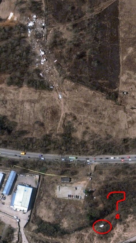
Looking at this image - - perhaps they tried to get below clouds to somewhere like 50-60m using radioalt, and then were caught by the rising terrain?
Looking at this image -
- perhaps they tried to get below clouds to somewhere like 50-60m using radioalt, and then were caught by the rising terrain?
Join Date: Apr 2000
Location: East Molesey, Surrey, UK
Posts: 102
Likes: 0
Received 0 Likes
on
0 Posts
Approach guidance the crew used is still not clear. Doesn't look like PAR, more like surveillance radar approach, which provides guidance like "slightly left of centreline, turn right two degrees, you should be passing [height]". Flightglobal has details on the airfield status at The Polish accident: circumstances - Learmount
Join Date: Jun 2002
Location: Europe/USA
Posts: 29
Likes: 0
Received 0 Likes
on
0 Posts
Get there itis
copied part of an article about the polish pilot and idiot boss.
But speculation was rife that the president's own entourage might have insisted the pilot continue the flight, despite orders from Russian air traffic control for the plane to land in Minsk or Moscow due to the bad weather conditions in Smolensk.
The high-profile delegation was on a tight schedule on Saturday to attend a memorial service for the 70th anniversary of the Katyn massacre. Kaczynski was known for his assertiveness towards pilots who had flown him on official business in the past.
In a widely reported case in 2008, he flew to Tbilisi in his presidential plane during the war in Georgia. When his pilot refused to land in the Georgian capital, insisting it was too dangerous to do so, Kaczynski reportedly entered the cockpit and tried to change his mind. The pilot refused, and the party landed in the Azerbaijani capital of Baku, and was forced to travel the remaining stretch to Georgia by car over arduous mountain roads. Attempts were subsequently made to sue the pilot for failing to obey orders, but the case was thrown out by prosecutors.
The former Polish president Lech Walesa said it was too early to cast blame, but also suggested the pilot may have come under pressure from the Polish president and his delegation to land, despite the severe fog blanketing the approach to the airport.
Join Date: Jan 2009
Location: Oxford, UK
Posts: 1,546
Likes: 0
Received 0 Likes
on
0 Posts
technical question
In the UK I have been confused by QFE and QNH settings, wondering why the ground was closer than it should have been, fortunately in VFR.....
Does a ground proximity warning system take into consideration the tops of trees? or the actual ground itself?
Does a ground proximity warning system take into consideration the tops of trees? or the actual ground itself?
Join Date: Oct 2004
Location: Europe
Posts: 483
Likes: 0
Received 0 Likes
on
0 Posts
Shortfinals:
I have been landing several times at military airfields in Poland.
(Which is legal for private flights, if approved in advance.)
It was VFR, so I will not comment on precision approaches in marginal weather.
I had the opportunity, due to courtesy of the staff, to visit the tower.
So I will just comment, what I saw, as a disused, but still operational PAR
equivalent. The way of use of it was commented to me by the tower staff.
The system consisted of two round CRT radar screens app. 40 cm diameter,
one for vertical and the other for lateral visualization of the aircraft position.
With colour crayons (markers) the lines were drawn on the glass surface
to represent the approach centreline, glide slope and runway threshold.
(I have no idea, how these lines and system was calibrated.)
The controller in front of those screens was giving the pilot voice commands
to keep him (the blip on the screen) on the lines. If the pilot was
not performing according to orders, ATC was able to give him command to abort.
The full authority and responsibility was on the side of the controller,
the pilot was just obliged to read back the orders and report runway in sight.
This might seem to be very primitive system, which it is, but according to my
CFI, a former fighter pilot, who did lots of such approaches, it worked well.
Similar, simple portable systems were supposed to be used on field grass
landing strips to be use in case of war or any emergency landing.
I have no Idea, if such system was in place in Smoleńsk, but it was
supposed to be standard in all Warsaw Pact countries.
It was probably eighter Russian or licensed RSP (Radiolokator Slepoj Posadki).
(Blind Landing Radar)
I am in no way connected to the military, so I can write here what I have seen,
and, what I suppose, is not classified.
I think military pilots, who know more about the system may be in trouble
if writing more about it on a public forum.
Approach guidance the crew used is still not clear. Doesn't look like PAR, more like surveillance radar approach, which provides guidance like "slightly left of centreline, turn right two degrees, you should be passing [height]".
(Which is legal for private flights, if approved in advance.)
It was VFR, so I will not comment on precision approaches in marginal weather.
I had the opportunity, due to courtesy of the staff, to visit the tower.
So I will just comment, what I saw, as a disused, but still operational PAR
equivalent. The way of use of it was commented to me by the tower staff.
The system consisted of two round CRT radar screens app. 40 cm diameter,
one for vertical and the other for lateral visualization of the aircraft position.
With colour crayons (markers) the lines were drawn on the glass surface
to represent the approach centreline, glide slope and runway threshold.
(I have no idea, how these lines and system was calibrated.)
The controller in front of those screens was giving the pilot voice commands
to keep him (the blip on the screen) on the lines. If the pilot was
not performing according to orders, ATC was able to give him command to abort.
The full authority and responsibility was on the side of the controller,
the pilot was just obliged to read back the orders and report runway in sight.
This might seem to be very primitive system, which it is, but according to my
CFI, a former fighter pilot, who did lots of such approaches, it worked well.
Similar, simple portable systems were supposed to be used on field grass
landing strips to be use in case of war or any emergency landing.
I have no Idea, if such system was in place in Smoleńsk, but it was
supposed to be standard in all Warsaw Pact countries.
It was probably eighter Russian or licensed RSP (Radiolokator Slepoj Posadki).
(Blind Landing Radar)
I am in no way connected to the military, so I can write here what I have seen,
and, what I suppose, is not classified.
I think military pilots, who know more about the system may be in trouble
if writing more about it on a public forum.
Last edited by Ptkay; 13th Apr 2010 at 13:46.