


Helicopter crash Superior Arizona 01/02/2026

Thread Starter


Joined: Mar 2011
Posts: 518
Likes: 50
From: London/Atlanta
Helicopter crash Superior Arizona 01/02/2026
Sadly 4 fatalities, apparently hit a recreational Slackline
At around 11 a.m. local time on Friday, Jan. 2, emergency services responded to reports of a crashed helicopter in the mountains near Telegraph Canyon in Superior. Four people died at the scene, the Pinal County Sheriff�s Office (PCSO) confirmed in a statement on
.
At around 11 a.m. local time on Friday, Jan. 2, emergency services responded to reports of a crashed helicopter in the mountains near Telegraph Canyon in Superior. Four people died at the scene, the Pinal County Sheriff�s Office (PCSO) confirmed in a statement on


Joined: Sep 2003
Posts: 2,081
Likes: 189
From: Redding CA, or on a fire somewhere
Sadly, the pilot did not check the Notams:
E81 |12/234 |Obstruction |12/26/2025 1400 |01/06/2026 0200 |OBST TIGHT ROPE WI AN AREA DEFINED AS 1NM RADIUS OF 331412N1110714W (3NM S E81)2800FT (600FT AGL) FLAGGED AND LGTD 2512261400-2601060200
E81 |12/234 |Obstruction |12/26/2025 1400 |01/06/2026 0200 |OBST TIGHT ROPE WI AN AREA DEFINED AS 1NM RADIUS OF 331412N1110714W (3NM S E81)2800FT (600FT AGL) FLAGGED AND LGTD 2512261400-2601060200

Joined: Oct 2019
Aviation Qualifications: Non-Aircrew
Posts: 1,689
Likes: 1,069
From: USA
This supports my belief that the FAA needs a better obstacle flagging system, something like ADS-B, which can transmit for all obstacles, including temporary ones, and mandatory ADS-B In or matching receivers with warnings set on proximity the way the FAA depicts in their videos on the subject. Keep in mind they don't need to be located on the obstacle, they simply need to be in sufficient proximity to provide sufficient range, like at the base of a broadcast tower where power is readily available and the unit is accessible for installation or repair. In this case, along with the NOTAM a rental/loaner ADS-B Out programmed with the details would be issued to the tight rope installers.
Fleet Manager

Joined: Aug 2006
Aviation Qualifications: CPL
Posts: 7,081
Likes: 2,938
From: Ontario, Canada
which can transmit for all obstacles
Perhaps a temporary recreational wire installation might not warrant such a measure, but probably simple, and maybe justified based upon the perceived risk and flying activity in the area.
Joined: Sep 2004
Aviation Qualifications: ATPL(H)
Posts: 2,371
Likes: 877
From: Canada
One would think with all the modern tech they could easily attach a map to the NOTAM.
Joined: Oct 2006
Aviation Qualifications: A&P
Posts: 1,346
Likes: 270
From: USA
In addition to the NOTAM the line also had aviation markers on it. Perhaps they were on a sightseeing flight given the pax relation snd all eyes were looking down vs ahead. Sometimes adding more "fixes" will not will not prevent everything just like the 130 down under
Joined: Apr 2009
Aviation Qualifications: Non-Aircrew
Posts: 1,571
Likes: 649
From: DM33
I have flown into Superior airport several times and I have used that mountain as the backdrop for sunrise photos of my aircraft.
The position coordinates in the NOTAM do not appear match the location of Telegraph Canyon. I could not find the TFR so I assume it has expired.
Is it possible the pilot did read the NOTAM but avoided the wrong place?
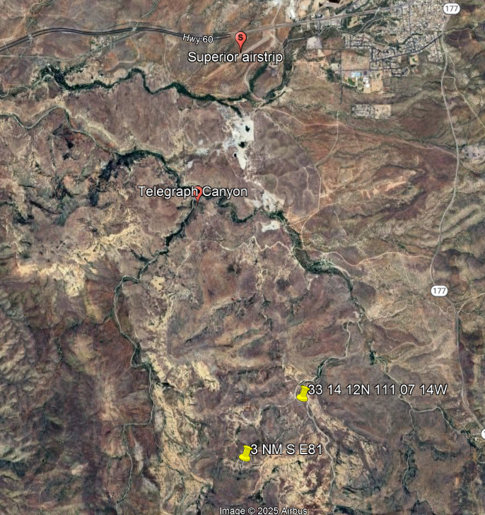
The position coordinates in the NOTAM do not appear match the location of Telegraph Canyon. I could not find the TFR so I assume it has expired.
Is it possible the pilot did read the NOTAM but avoided the wrong place?
Joined: Apr 2009
Aviation Qualifications: Non-Aircrew
Posts: 1,571
Likes: 649
From: DM33
N3502P, a 2023 MD 369FF likely based at Pegasus Airpark Queen Creek, was seen by ADS-B 7.6 NM South of Superior at 17:55 Z. There were no later position reports.
Last edited by EXDAC; 4th January 2026 at 14:30. Reason: revise aircraft type

Joined: Sep 2001
Aviation Qualifications: CPL
Posts: 2,782
Likes: 203
From: Toronto
Obstacle warning system
Flarm maintains these databases for Europe. Garmin et al would do well to develop similar databases for North America and integrate with terrain warning.
The FLARM Obstacle Warning System alerts pilots of fixed obstacles such as powerlines, cable cars, and antenna towers that could pose a danger to aircraft. Obstacle databases can be installed in all major FLARM devices, including OEM products. To enable it, a database file for the relevant region with a valid license is installed in the device


Joined: May 2002
Aviation Qualifications: ATP+Mil
Posts: 18,633
Likes: 1,072
From: Downeast
In the Pacific Northwest it quite common for Loggers to string cables with great rapidity and not all of them find their ways into NOTAMS.
In some rather inclement weather I passed up and over the mountain ridge and spent two hours at our Mill then loaded up and started back to home.
As I descended from the top of the ridge using the exact same route I had used just a few hours before...due to some upslope fog/cloud I deviated over to the edge of the canyon and whizzed across the top of a newly erected high lead logging line. Ironically, I was flying the same type and model of the aircraft in this accident.
Lady Luck smiled broadly upon me that day! Had the canyon been clear of fog and cloud I probably would have struck the cable as they are very. hard to see especially when you think there are none around where you are flying as you are not actively looking for them.
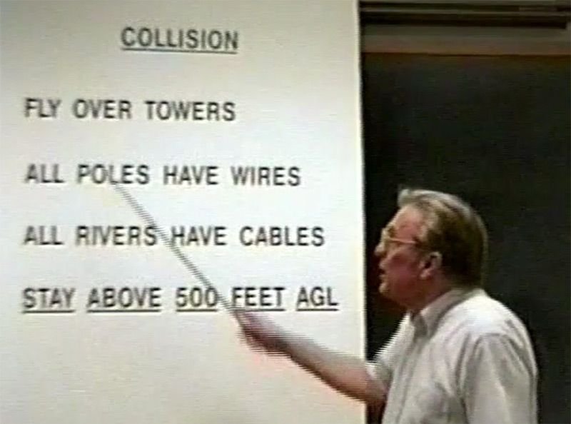
This stay 500 feet ago works but it should mean 500 feet above the potential obstacles.
500 feet above the Ridgeline heights would have worked in my case.....500 feet above the canyon floor would not have and in all likelihood would. have set me up for disaster.
Gordy can provide some excellent discussion about this kind of accident as he survived one of them!
In some rather inclement weather I passed up and over the mountain ridge and spent two hours at our Mill then loaded up and started back to home.
As I descended from the top of the ridge using the exact same route I had used just a few hours before...due to some upslope fog/cloud I deviated over to the edge of the canyon and whizzed across the top of a newly erected high lead logging line. Ironically, I was flying the same type and model of the aircraft in this accident.
Lady Luck smiled broadly upon me that day! Had the canyon been clear of fog and cloud I probably would have struck the cable as they are very. hard to see especially when you think there are none around where you are flying as you are not actively looking for them.
This stay 500 feet ago works but it should mean 500 feet above the potential obstacles.
500 feet above the Ridgeline heights would have worked in my case.....500 feet above the canyon floor would not have and in all likelihood would. have set me up for disaster.
Gordy can provide some excellent discussion about this kind of accident as he survived one of them!
Joined: Sep 2024
Posts: 21
Likes: 3
From: Florida
Yeah, if he would have seen that NOTAM, it would never have happened (eye roll).
Joined: Nov 2006
Posts: 1,951
Likes: 90
From: After all, what�s more important than proving to someone on the internet that they�re wrong? - Manson
It is done, just not so well by the FAA. Planning and EFB apps do, like Foreflight Rocketroute etc etc. Apparently there are a few AI based platforms popping up as well. i.e. Notamify, AeroNOTAM etc etc
Joined: Sep 2003
Posts: 2,081
Likes: 189
From: Redding CA, or on a fire somewhere
Joined: Apr 2009
Aviation Qualifications: Non-Aircrew
Posts: 1,571
Likes: 649
From: DM33

Joined: Apr 2009
Aviation Qualifications: Non-Aircrew
Posts: 1,571
Likes: 649
From: DM33
The Garmin G3X Touch system displays graphical TFR because the graphical data is included in the FIS-B data set. The data set does not include graphical NOTAM data, only text data.
Perhaps there is some hope that the planned update to the NOTAM system will include graphical NOTAM data in FIS-B. I paid a lot of money for "/G" capability and I don't want a tablet cluttering up my cockpit.
Perhaps there is some hope that the planned update to the NOTAM system will include graphical NOTAM data in FIS-B. I paid a lot of money for "/G" capability and I don't want a tablet cluttering up my cockpit.
Joined: Oct 2019
Aviation Qualifications: Non-Aircrew
Posts: 1,689
Likes: 1,069
From: USA
What I meant was - that the FAA mandates the use of a single system that uses local broadcasting to show obstructions temporary or permanent. It is seen as required to put lights on towers; the same should occur in the RF spectrum.
Joined: Sep 2004
Aviation Qualifications: ATPL(H)
Posts: 2,371
Likes: 877
From: Canada
Discussed in detail here:
https://www.youtube.com/watch?v=3kMKAO_CLVQ&pp=2AYQ
https://www.youtube.com/watch?v=3kMKAO_CLVQ&pp=2AYQ
A very sad case and the NOTAM seems to have been available only if you checked the airport ( which was not his destination ). There seems to be questions about the visibility of the markings too.
That it was visible on foreflight is good thing but when doing a VFR flight you have done hundreds of times would you even look at it?
What is really scary is that the helicopter looking for them nearly hit the wire too.
