


Helicopter crash Superior Arizona 01/02/2026


Joined: Nov 2006
Posts: 1,951
Likes: 90
From: After all, what�s more important than proving to someone on the internet that they�re wrong? - Manson


Joined: Sep 2004
Aviation Qualifications: ATPL(H)
Posts: 2,371
Likes: 877
From: Canada
The actual regulation is in 14 CFR part 77 -
(a) Any construction or alteration that is more than 200 ft. AGL at its site."
This appears to be a requirement for notification not a requirement for approval. Clearly FAA was aware since a NOTAM was issued.
I have yet to see any images that show anything like an "aviation marker". Please post if you have any such image.
"77.9 Construction or alteration requiring notice.
If requested by the FAA, or if you propose any of the following types of construction or alteration, you must file notice with the FAA of:(a) Any construction or alteration that is more than 200 ft. AGL at its site."
This appears to be a requirement for notification not a requirement for approval. Clearly FAA was aware since a NOTAM was issued.
I have yet to see any images that show anything like an "aviation marker". Please post if you have any such image.
Joined: Apr 2009
Aviation Qualifications: Non-Aircrew
Posts: 1,571
Likes: 649
From: DM33
Joined: Sep 2004
Aviation Qualifications: ATPL(H)
Posts: 2,371
Likes: 877
From: Canada
Quote:
Originally Posted by albatross
Perhaps FAA were aware and issued the NOTAM but did anyone visit the site to confirm adequate and visible markings were in place?
I understand that notification seems to be all that is required. of the persons putting the line in place.
My question is does the FAA , besides issuing the NOTAM perhaps occasionally show up to see that the required markers and lights are indeed in place and of a adequate size, colour and brightness to allow pilots to see and avoid the obstacle?
Joined: Dec 2004
Posts: 379
Likes: 68
From: canada
I understand that notification seems to be all that is required. of the persons putting the line in place.
My question is does the FAA , besides issuing the NOTAM perhaps occasionally show up to see that the required markers and lights are indeed in place and of a adequate size, colour and brightness to allow pilots to see and avoid the obstacle?[/QUOTE]
I think that's a great question. Even something as simple as a phone call to the hill operator the day before the intended flight to inquire if everything is in place and visible. Not that's not to say you can easily see the obstruction from the ground, but are there other drivers/operators who have been operating in the area in the last couple of days who could add to the conversation.
Fly safe, everyone....
Joined: Apr 2009
Aviation Qualifications: Non-Aircrew
Posts: 1,571
Likes: 649
From: DM33
Prelim NTSB report here - https://data.ntsb.gov/carol-repgen/a...ort/202237/pdf
Joined: Sep 2004
Aviation Qualifications: ATPL(H)
Posts: 2,371
Likes: 877
From: Canada
Prelim NTSB report here - https://data.ntsb.gov/carol-repgen/a...ort/202237/pdf
Depending on winds and approaching aircraft could be looking at the diameter of the windsock or its length … or some combination thereof
How big are the windsock's?
How bright are the LED lights…were they visible during the day or solar charged and operated only dusk to dawn?
In the rules for marking cable spans I saw no mention of windsocks. and markers seem to be mandated 200 feet apart. and be 36 inches in diameter. I could find no diagram specific to slacklines.
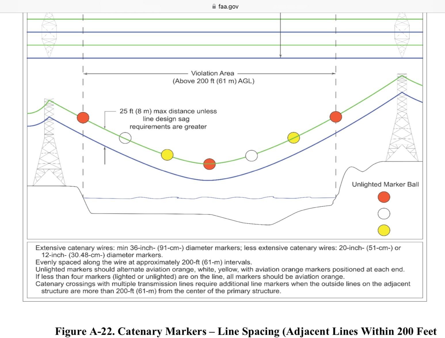
.
Last edited by albatross; 24th January 2026 at 16:19. Reason: diagram added.

Joined: Apr 2000
Aviation Qualifications: ATP+Mil
Posts: 10,959
Likes: 1,814
From: EGDC
So you don't have a free system like this in the US? https://www.notaminfo.com/ukmap
Joined: Oct 2019
Aviation Qualifications: Non-Aircrew
Posts: 1,689
Likes: 1,069
From: USA
Since the helicopter hit the slack line, it's very likely that the slackline was against the sky and was a similar brightness as the sky behind it.
Had the helicopter been at a greater altitude the slack line would have been very visible, as it is in the photo in the NTSB report. I think a similar problem happens with the LEDs and the wind socks - the contrast is insufficient to be readily noticed against the sky by a pilot who is likely concentrating on the distance below the aircraft and to surrounding mountains.
I have no doubt that the concern was empirically correct on every other trip, but it does suggest that the FAA has not provided sufficient guidance or research over what marking is sufficient.
I'll just repeat - the FAA needs to implement a radio based system of alerting that can be used by ground operators to mark temporary and permanent obstructions and to mandate the use and make it required equipment to receive and give audio and visual feedback to the pilots when proximity is computed. Instead of just a NOTAM the FAA could require transmitters that would convey suitable data, making for a rental market for such temporary things as tower cranes or logging operations.
The guy in New Zealand has recently upgraded his system that does this sort of detection to not only include proximity and altitude, but also give voice outputs so that a drone operator with First Person Video glasses doesn't have to look at a receiver screen to be informed of a potential conflict with manned aircraft. He's one guy, a hobbyist, with a small budget. Why the FAA won't or hasn't moved forward on this boggles the mind.
For Beta software, it does the job.

Joined: Sep 2003
Posts: 2,081
Likes: 189
From: Redding CA, or on a fire somewhere
Originally Posted by [email protected]
So you don't have a free system like this in the US? https://www.notaminfo.com/ukmap
https://notams.aim.faa.gov/notamSear....html#/results
Joined: Apr 2000
Aviation Qualifications: ATP+Mil
Posts: 10,959
Likes: 1,814
From: EGDC
Yes we do:
https://notams.aim.faa.gov/notamSear....html#/results
That doesn't seem anything like as easy to use as a map you can scroll and zoom which show the dimensions of each notam as well as the details.
https://notams.aim.faa.gov/notamSear....html#/results
That doesn't seem anything like as easy to use as a map you can scroll and zoom which show the dimensions of each notam as well as the details.
