


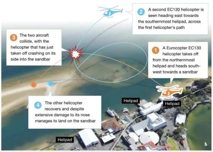
Two helicopters collide - Gold Coast, Queensland - Sea World 2/1/2023

DroneDog: The white covers for these floats might have been reflecting in the gloss paint of -XKQ which may explain what the apparent white on side of -XKQ as seen in the on-board footage from -XH9 released by 7 News.
See also my update to post #313 with link to Channel 9 release of the on-board video but now without using watermarks.
Last edited by helispotter; 9th Jan 2023 at 00:20.

Regulator Systemic Failure.
This airspace between Brisbane and Gold Coast Covers two airfields YHEC and YSPT and many Helicopter pads, the busiest being YSWD YGHT, YCAX and YXHG but YSPT also has considerable Helicopter operations associated with its maintenance facility, The air space is simply Class G with a CTAF frequency assigned to some of the landing areas, there is no promulgated Danger Area (eg: Archerfield training area) or Broadcast Zone (eg: Redcliff) or Mandatory Broadcast Zone (eg: Ballina).
This gap now seems brutally obvious. This small area between two Primary Airports often has intense bursts of aviation activity!
Regulators have been asleep or worse and this is a contributing factor to this accident. The ATSB have a lot of video, the new helicopters were wired up with tourist cameras and weeks of CTAF audio are in their hands, they already have a good idea of the procedural and human performance issues that contributed to this accident but I hope that they look long and hard at the relevant regulatory authorities and how inaction or even negligence has contributed to the accident.
Fraught as it is, I don't think our regulatory situation is at fault in this particular accident. Two helicopters from the same company operating in the same area should have had an agreed means of separating themselves, be it standard routes / altitudes, radio talk or whatever. SOPs in the company ops manual would probably already be there, and whatever the radio situation was (company radio, CTAF, area VHF or whatever) they should have both been listening out on a common frequency and making calls as per whatever their procedures were.
If there were no standard company procedures, or even ad-hoc ones for the day agreed on between the pilots, then that's a 'brutally obvious gap'. This is not two aircraft with no company affiliation happening to blunder into the same airspace, it's known traffic in a known area for both.
Maybe they were following some company separation procedure and it broke down - who knows? All I'm saying is that two or more company aircraft going round and round on scenics should have some mutually known method of checking where the other/s are, and ideally agreed flight paths that provide a passive separation as well, if possible.
The following 2 users liked this post by Arm out the window:
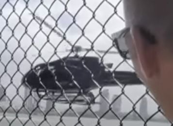
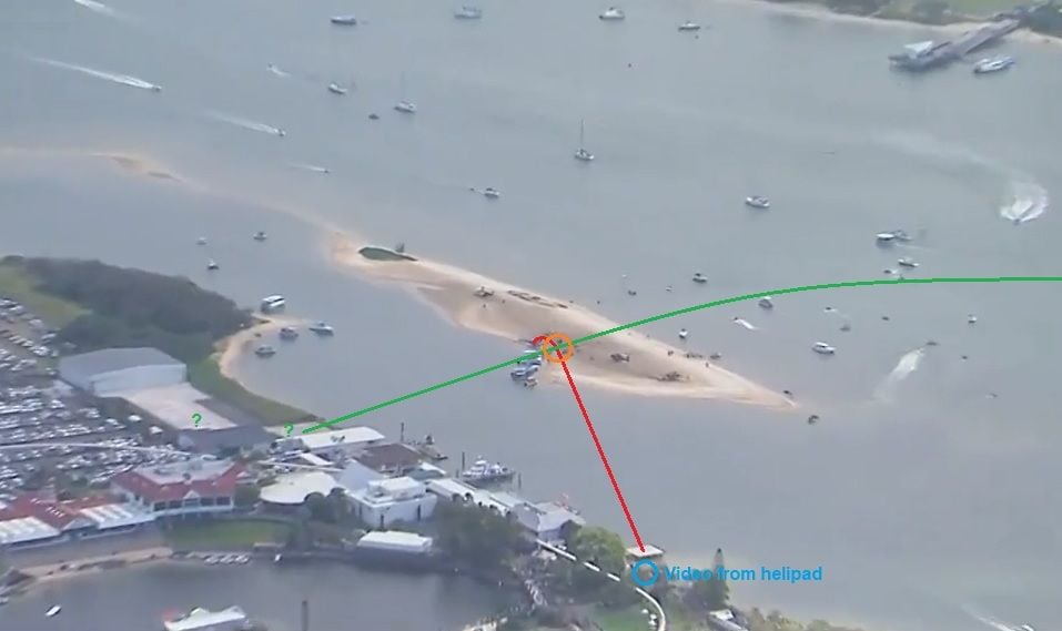
I think the dark object is the shadow of that tree, with the white branches as the white objects. See photos in #307 and #309. It's in exactly the right spot in relation to the helipad.
The video through the fence shows the departing chopper pretty much maintains a constant heading up to where it finishes just before impact. Looking at the onboard video from the arriving aircraft, if the climbing one is still directly in line with the helipad, it should be more nose on I would have thought.
If you take the point where the departure video freezes shortly before impact, and correlate that to be approximately where the choppers might be when visible in relation to each other in the arrival video, the helipad would, I think, not appear to be directly behind the departing one.
Last edited by Traffic_Is_Er_Was; 9th Jan 2023 at 03:22.
- Radio call: �X-ray Kilo Quebec, EC One Thirty. Ready for the lift from the old [XYZ] pad. Take- off in southerly direction. X-ray Hotel Niner: Your Position?�
- Look-out: Even if there is no response from XH9 or any other traffic, visually check take-off path left, right, front, up. This requires to lean and stretch around the cockpit to get a clear view in all directions.
- Visually check for �aircraft on final�, here any aircraft coming from behind. This requires to do a 90 degree hover turn to the left to check area behind, before committing to the take-off.
The following users liked this post:
I think the dark object is the shadow of that tree, with the white branches as the white objects. See photos in #307 and #309. It's in exactly the right spot in relation to the helipad.
The video through the fence shows the departing chopper pretty much maintains a constant heading up to where it finishes just before impact. Looking at the onboard video from the arriving aircraft, if the climbing one is still directly in line with the helipad, it should be more nose on I would have thought...
The video through the fence shows the departing chopper pretty much maintains a constant heading up to where it finishes just before impact. Looking at the onboard video from the arriving aircraft, if the climbing one is still directly in line with the helipad, it should be more nose on I would have thought...
The following users liked this post:
Regulator Systemic Failure.
This airspace between Brisbane and Gold Coast Covers two airfields YHEC and YSPT and many Helicopter pads, the busiest being YSWD YGHT, YCAX and YXHG but YSPT also has considerable Helicopter operations associated with its maintenance facility, The air space is simply Class G with a CTAF frequency assigned to some of the landing areas, there is no promulgated Danger Area (eg: Archerfield training area) or Broadcast Zone (eg: Redcliff) or Mandatory Broadcast Zone (eg: Ballina).
This gap now seems brutally obvious. This small area between two Primary Airports often has intense bursts of aviation activity!
Regulators have been asleep or worse and this is a contributing factor to this accident. The ATSB have a lot of video, the new helicopters were wired up with tourist cameras and weeks of CTAF audio are in their hands, they already have a good idea of the procedural and human performance issues that contributed to this accident but I hope that they look long and hard at the relevant regulatory authorities and how inaction or even negligence has contributed to the accident.
This airspace between Brisbane and Gold Coast Covers two airfields YHEC and YSPT and many Helicopter pads, the busiest being YSWD YGHT, YCAX and YXHG but YSPT also has considerable Helicopter operations associated with its maintenance facility, The air space is simply Class G with a CTAF frequency assigned to some of the landing areas, there is no promulgated Danger Area (eg: Archerfield training area) or Broadcast Zone (eg: Redcliff) or Mandatory Broadcast Zone (eg: Ballina).
This gap now seems brutally obvious. This small area between two Primary Airports often has intense bursts of aviation activity!
Regulators have been asleep or worse and this is a contributing factor to this accident. The ATSB have a lot of video, the new helicopters were wired up with tourist cameras and weeks of CTAF audio are in their hands, they already have a good idea of the procedural and human performance issues that contributed to this accident but I hope that they look long and hard at the relevant regulatory authorities and how inaction or even negligence has contributed to the accident.
You also claimed that you have never heard any departing radio calls from the helicopters lifting. In reality those were made every time a helicopter departed from both Seaworld and Marina Mirage. Your comment once again speaks more about you and your airmanship than it does of anyone else
If you think that a red line around this area with 'D' followed by a number somehow would have changed the outcome of this tragedy, I have a bridge to sell to you
There is a common frequency that everyone who flies above south Stradbroke Island, Sea World, The Gold Coast & The hinterlands uses. It's 119.00 (and additionally it may also be prudent to have 119.50 - Brisbane Centre on the second com)
Following your logic, the common frequency 126.7 for many airports Australia wide would have mid-air collisions every day
In normal times I would not have given you a second of my time. In these times, where the media is looking for the next story - uneducated comments like yours, must be rooted out
When either not knowing or bothering to look for a frequency on a VTC, after missing a radio call that gets made hundreds of time a day everyday, after suggesting some red line around a map you haven't bothered to look at or ignored would have made a difference, I just want to say that maybe it's good that you keep coming back to this thread, as perhaps out of everyone here; you might have the most to learn from this accident
Last edited by nikoel; 9th Jan 2023 at 07:58.
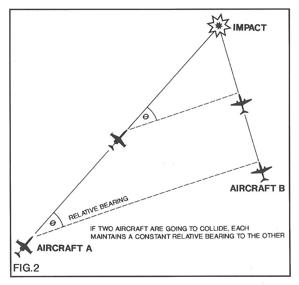
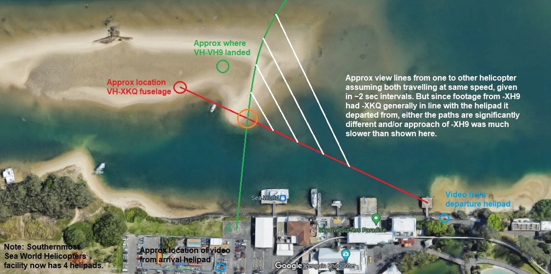
I understand, however the departing chopper is tracking directly away from its helipad more or less to impact. The arriving helo would have to be at the point of impact for the departing helo to be still in line with the helipad from his point of view. In that case, the climbing helo would be nose on. The geometry of the videos doesn't work for me. You extrapolate the dotted bearing lines in the above back and as per the diagrams, they don't go back to the same place.
I understand, however the departing chopper is tracking directly away from its helipad more or less to impact. The arriving helo would have to be at the point of impact for the departing helo to be still in line with the helipad from his point of view. In that case, the climbing helo would be nose on. The geometry of the videos doesn't work for me. You extrapolate the dotted bearing lines in the above back and as per the diagrams, they don't go back to the same place.
Roughly estimated paths from one perspective (unsure which pad was planned to be used by -XH9:
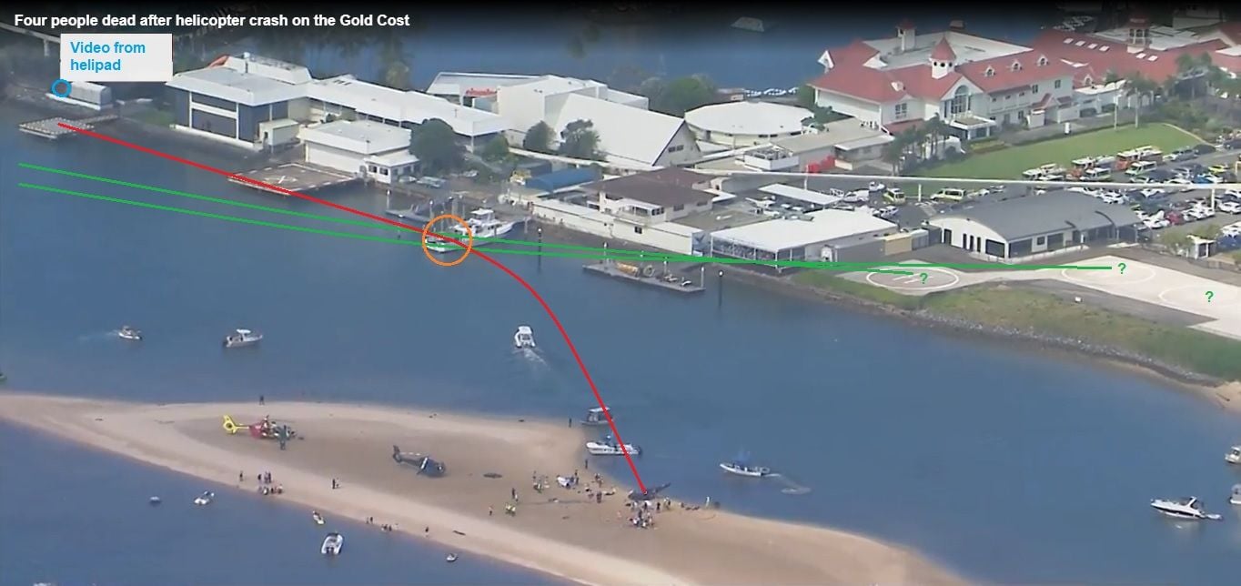
and estimated from another perspective:
and then an attempt to estimate path from directly above:
The following users liked this post:
Its the why that will be the focus of the investigation particularly why a helipad with a white cross on it was being used.
There is a cross on the helipad immediately to the South.
The following 2 users liked this post by 601:
The following users liked this post:
I trust you are not suggesting that departing from a piece of ground marked with an �X� absolves other aircraft from their duty to look & avoid.
As far as I understand the ICAO guidelines, the �X� across a helipad signals to third parties that they can�t land there and then blame the operator of the non-helipad when things are not as expected on the ground.
Nothing should preclude the site owner, or his agents, from operating from such site, at pilot�s discretion, like from any router unimproved site.
I think this would be in the public interest and would accelerate the learnings from such incident for the rest of us. And I can�t see how such disclosure would negatively affect the integrity of the investigation.
Certainly the investigators should not delay the release of such information for any other reason than to obtain unbiased witness reports. Once this is done, the answer information should be made public.
The following users liked this post:
As far as I understand the ICAO guidelines, the “X” across a helipad signals to third parties that they can’t land there
The other pad that the accident aircraft took off from is right beside the ticket booth so lot of machines come and go from that pad. Its an ease of convenience for those inside the park who have bought tickets, buy ticket - walk 20ft to the helicopter and take off rather than having to go outside the park and then over to the new facility.
The following users liked this post:
Can I ask what you think you would learn from public disclosure of the footage possibly held by the ATSB at this point? While you might believe that you have a grasp of the proximate cause, do you have all the information concerning the operation, supervisory factors, preconditions and latent organisational issues? How about the regulatory environment? Believe me, those are the areas the ATSB will be investigating and until that is done, all evidence they receive or collect is confidential and protected - by law. If a state accident investigator loses the trust of the aviation community, their already difficult job would be considerably harder. Would you have them release a CVR ahead of publication? What if they did and you were a crew member, would you be happy with that?
Diligent professionals will undoubtedly reach their own conclusions based on what is already available in the media, and reflect on how they conduct their business accordingly, as they rightly should. Once the ATSB publish their final report, they may conclude that Safety Recommendations are required based on their findings. At that point, the full picture will emerge for industry to reflect on, adapt and hopefully, prevent a similar event from occurring again.
Diligent professionals will undoubtedly reach their own conclusions based on what is already available in the media, and reflect on how they conduct their business accordingly, as they rightly should. Once the ATSB publish their final report, they may conclude that Safety Recommendations are required based on their findings. At that point, the full picture will emerge for industry to reflect on, adapt and hopefully, prevent a similar event from occurring again.
The following 4 users liked this post by Ex Machina:
The other pad that the accident aircraft took off from is right beside the ticket booth so lot of machines come and go from that pad. Its an ease of convenience for those inside the park who have bought tickets, buy ticket - walk 20ft to the helicopter and take off rather than having to go outside the park and then over to the new facility.
This investigation will be taking a good look at the organisational aspects of the accident and as a consequence it will not be finalised anything shorter than 18 months. The investigator in charge of this will not be working fulltime on this until completion. While they are obtaining the evidence for this they will probably have another five investigations they are responsible for.
I'm not debating the impact. I've seen all that before. I'm debating the suggestion that something identified in the video filmed from inside one of the helos prior to impact is the other helo. Nothing in that linked clip informs me otherwise.
That second video still in helispotter's #329. That shows the white object that appears to be in front of what has been suggested is the departing helicopter in the enhanced videos. It's the large white marquee/shed, in front of and to the left of the shadow of the tree with the large white limbs.

Join Date: Jan 2023
Location: Ireland
Posts: 1
Likes: 0
Received 0 Likes
on
0 Posts
As mentioned by Traffic_Is_Er-Was in post 324, I also think the black "shape" could be just shadow under a tree and the white "stripe" is a low wall painted white but time will tell.
As regards the pilot of the landing helicopter not looking left for traffic, is it possible he thought the departing heli took off from the same location in front of him with four helipads where he was going to land and the departing heli would be in front, moving to his right, to pass on his right side, separation would be increasing and it would not be a factor for his own landing?
As regards the pilot of the landing helicopter not looking left for traffic, is it possible he thought the departing heli took off from the same location in front of him with four helipads where he was going to land and the departing heli would be in front, moving to his right, to pass on his right side, separation would be increasing and it would not be a factor for his own landing?