


SAR S-92 Missing Ireland

Serious question Crab, would a Pilot use NVG in proximity to a lighthouse?

There is an automatic gain control on the NVG tubes which effectively does the same as increasing or decreasing the ISO on your camera - when it is really dark, the gain control goes to max to amplify as much light as possible but you then get unwanted 'noise' speckling, honeycombing etc.
In a bright light, the gain control does the opposite - partly to prevent damage to the tubes - but you only have about a 40 degree field of view so you can look slightly away from the light source and keep a good picture.
In a bright light, the gain control does the opposite - partly to prevent damage to the tubes - but you only have about a 40 degree field of view so you can look slightly away from the light source and keep a good picture.
Originally Posted by [email protected]
Despite all the contributory factors, there is no doubt in my mind that, had they been wearing NVG, they would not have hit the island.
With NVG, the pilots would have seen the terrain (Dara herself mentioned being visual with the sea surface and that was unaided night vision) and made the avoiding turn early - and probably manually - rather than utilising the heading bug on the AP after confirming with the rearcrew about the need to change course. That was a delay that cost them their lives.
With NVG, the pilots would have seen the terrain (Dara herself mentioned being visual with the sea surface and that was unaided night vision) and made the avoiding turn early - and probably manually - rather than utilising the heading bug on the AP after confirming with the rearcrew about the need to change course. That was a delay that cost them their lives.
The reality is, and as the report finds, the crew were essentially set up to fail by an insurmountable (for them, on that night) series of systemic failures. Even NVGs might have made no difference at all because as a crew they were trucking along at 200� in the belief that they had Company proven safe lateral and vertical clearance. Any crew that believes they are currently safe will by human nature be less aroused and therefore less diligent. In this scenario even with NVGs it�s likely there lookout on that stormy night would have been sub optimal; just like the sub optimal use of radar ranging and any of the many other factors that might just have saved their lives but they failed to do with the required diligence. All because they were misled by those many systemic failures into believing they were safe when they were anything but.
Only part way through the report, but I get the impression that no real detailed approach brief was made, had attention been paid to the route guide all the information was there, on the map Blackrock 282', in the notes Blackrock 310'. Unfamiliarity played a role, Captain had not been there for 15 years and Co-pilot not for some time, all the more reason for attention to the route guide. Then again there is operating at an unsocial hour and attendant human factors. NVGs may have been nice, but they were not relevant to the accident in my view.
Most interested in seeing what crab has to say, being in the business.
Most interested in seeing what crab has to say, being in the business.

Join Date: Feb 2002
Location: Somewhere warm
Posts: 9
Likes: 0
Received 0 Likes
on
0 Posts
I respectfully have to say that NVG's would probably have saved their lives, especially of we are saying Dara saw the sea surface with the naked eye. With over four years of using white phosphor NVG's, I cannot understand any SAR operation in the world now not using NVG's as standard. They seem to be reliant on the FLIR, and when all said and done, the information was there from an operator who clearly could see what was ahead, as he said there was an Island and move right. We operate the FLIR in support of NVG's on night ops. The fact there is NO reference to NVG's in the report and recommendations surprises me. And the fact the Coast Guard have had a program running for 11 years, and now still only one aircraft operating them.
Join Date: Feb 2002
Location: Somewhere warm
Posts: 9
Likes: 0
Received 0 Likes
on
0 Posts
I think that’s just too simplistic a statement Carb. I agree that had they been using NVGs the ‘might’ have seen the island but you cannot say that they ‘would’ have seen the island.
The reality is, and as the report finds, the crew were essentially set up to fail by an insurmountable (for them, on that night) series of systemic failures. Even NVGs might have made no difference at all because as a crew they were trucking along at 200’ in the belief that they had Company proven safe lateral and vertical clearance. Any crew that believes they are currently safe will by human nature be less aroused and therefore less diligent. In this scenario even with NVGs it’s likely there lookout on that stormy night would have been sub optimal; just like the sub optimal use of radar ranging and any of the many other factors that might just have saved their lives but they failed to do with the required diligence. All because they were misled by those many systemic failures into believing they were safe when they were anything but.
The reality is, and as the report finds, the crew were essentially set up to fail by an insurmountable (for them, on that night) series of systemic failures. Even NVGs might have made no difference at all because as a crew they were trucking along at 200’ in the belief that they had Company proven safe lateral and vertical clearance. Any crew that believes they are currently safe will by human nature be less aroused and therefore less diligent. In this scenario even with NVGs it’s likely there lookout on that stormy night would have been sub optimal; just like the sub optimal use of radar ranging and any of the many other factors that might just have saved their lives but they failed to do with the required diligence. All because they were misled by those many systemic failures into believing they were safe when they were anything but.
NVGs might have saved them but there were so many other systemic and behavioural failures which are highlighted by the report. I agree that any SAR helicopter Operator routinely exposing their crews to the low-level environment in poor weather should equip and train for NVG use as a duty of care. They are not a panacea though; twice in my flying career I came extremely close to flying into obstructions (which had been recce'd during the day, and were accurately plotted) whilst wearing NVGs at low level. It's a high workload environment that demands currency, competency and procedures which are as safe as is reasonably possible. Sadly, this report confirms that this wasn't the case.
I stand by my assertion that they would not have hit the island had they been equipped with NVG.
When you do a night letdown over water wearing NVG you are mentally prepared for the visual environment - when you are relying on radar and AFCS procedures only, then you are in a different (almost IFR) mindset.
Having used the AFCS to get down to low level, they would have been using NVG as primary collision avoidance and FLIR and radar as secondary.
They would have seen the island in that case.
Having done SAR radar/NVG letdowns I'm convinced that a crew using the procedures and training I was exposed to in all probability would not have flown in to a large piece of rock. These guys may have been saved by NVG but it's impossible to make that assumption. I still feel that procedural/behavioural influences were a big factor as was automation bias. If you're confident the kit and the procedure is sound (as they were) then you're way less likely to be expecting a nasty surprise. NVGs may, or may not, have been their saviour.
Join Date: Mar 2021
Location: Tellus
Posts: 25
Likes: 0
Received 0 Likes
on
0 Posts
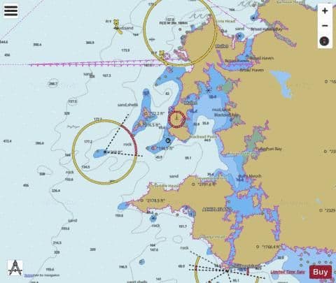
Marine charts
Reading the report it does not say anything about why they did not use the marine charts?
Over water, outside the coastline, surely they are the most detailed maps around?
Why using on shore maps....or am I missing something.
Over water, outside the coastline, surely they are the most detailed maps around?
Why using on shore maps....or am I missing something.
Join Date: Sep 2021
Location: Cantucket
Posts: 40
Likes: 0
Received 0 Likes
on
0 Posts
Probally because they were in a helicopter�. Not a boat !
The family of both pilots have released statements and in the case of the pilot in commander have given a radio interview . Obviously their views would differ from the comments here as they are more personal . However even the family�s of the pilots have different views . One more defensive than the other perhaps .
https://www.rte.ie/radio/radio1/clips/22026455/
Captain Fitzpatrick�s father on a national radio station .
captain Fitzpatrick�s family statement released on Twitter
[img]blob:https://www.pprune.org/cc6b67d7-81de-4d67-89cc-f8e12ce3ab6f[/img]
Captain Mark Duffy�s wife�s statement in a national news paper.
https://www.independent.ie/irish-new...-41019248.html
Join Date: Mar 2021
Location: Tellus
Posts: 25
Likes: 0
Received 0 Likes
on
0 Posts
Originally Posted by Johnthemidjit;[url=tel:11138239
11138239[/url]]Probally because they were in a helicopter�. Not a boat !
Join Date: Feb 2002
Location: Somewhere warm
Posts: 9
Likes: 0
Received 0 Likes
on
0 Posts
�well, why would you have the marine charts loaded in the tough-book if not utilizing them when needed. Flying at 200 feet over water they seam to be the most sensible charts to look at to determine your location and any islands in your way. The report does not say anything about it�
This from early October 2021, Afloat Article."
A delay in using night vision goggles purchased by the State for Irish Coast Guard search and rescue helicopter crews has been criticised in the Comptroller and Auditor General�s (C&AG) annual report. Although over 4.3 million euro was paid by the Department of Transport to CHC Ireland in 2013 to ensure night vision imaging systems (NVIS) capability, only one of four search and rescue bases had been approved for this as of June 2021, the C&AG�s report for 2020 states.
The C&AG notes that a March 2010 report, which was prepared before the tender process for the Irish Coast Guard search and rescue (SAR) helicopter contract, had recommended helicopters be fitted with an NVIS system.
That 2010 report also recommended that night vision goggles and crew training should be provided when funding became available.
�In 2013, the Department of Transport paid �4.305 million to the company providing SAR in Ireland to ensure the five helicopters used for the service are equipped with NVIS capability,� the C&AG states.
� Another �527,000 was paid in 2015 for 24 sets of night-vision goggles,� it says, and an initial payment of �1.714 million was made in 2018 for training that began in November 2019.
�The night vision goggles would remain the property of the Coast Guard and, on expiry of the current contract, the goggles would continue to be available for use by SAR crew,�the C&AG says.
It notes the department expects the training to be completed by 2022. Sligo is the only SAR base so far approved for NVIS capability by the Irish Aviation Authority (IAA).
The C&AG notes that it will be �some time before all the bases are operating in the same way�.
The Department of Transport told the C&AG that visual reference to the pilots� outside world is essential for safe and effective flight.
During daylight hours, the pilot relies heavily on the out-the-windshield view of the airspace and terrain for situational awareness, it explained.
� During night flying, the pilot can improve the out-of-the-windshield view with the use of a NVIS. Overall, NVIS as an additional aid to navigation and search, in suitably equipped aircraft using appropriately trained crews enhances operational effectiveness and safety for both SAR and helicopter emergency medical service (HEMS) operations,� the department said.
It said that NVIS have been shown to pick up small lights, such as lights on lifejackets, hand-held torches and distant vehicles at much greater ranges than the naked eye.
� When operating overland, NVIS assist the crew in navigating, seeing and avoiding terrain and obstructions as well as being able to identify survivors earlier than with the naked eye,�the department said, and can increase the crew�s overall search capability as NVIS enhances visibility.
The department said that NVIS can provide a �back-up to the forward-looking infrared system (FLIR) if the FLIR suffers an unserviceability in-flight�.
It said that NVIS can assist in identifying suitable landing sites more easily under SAR flight rules. This will also enable the helicopters to access the offshore islands that are without aviation infrastructure such as Inishbofin for medical evacuations under SAR flight rules.
It said that during night-time commercial air transport operations (i.e. HEMS incidents), landing is only permitted at company approved surveyed sites, but NVIS has the potential to remove this restriction and allow crews to land safely at sites which have not been surveyed.
�Overall, the use of night vision aid technology increases night-time situational awareness for pilots and technical crew,�the department said.
It also said that use of night vision goggles �markedly decreases the possibility of collisions with terrain or manmade obstruction�.
In its response to questions raised by the C&AG, the department�s accounting officer said that �of necessity, the implementation of the NVIS has been done on a phased basis�.
�Clearly, training can only take place when the helicopters are correctly equipped and goggles are available to use. Regrettably, the timelines have been far longer than original anticipated,� the department said.
It said the Irish Coast Guard had �consistently pressed the company to deliver the training as quickly as possible, to explore all possible options and to engage with the IAA throughout to determine whether certain elements could be accelerated, all with due regard to safety and to ensuring that the core SAR availability was unaffected�.
It also said that re-fitting the helicopters to make them compatible with NVIS operations �does not confer a competitive advantage to the company� in bidding for the new SAR contract.
The C&AG said that � significant payments were made from voted funds as long ago as 2013, and the planned capability has not yet been delivered across the service�.
�On that basis, I am not persuaded that good value for money for the taxpayer has been achieved from this expenditure,� he said.
Oireachtas Committee of Public Accounts chairman Brian Stanley welcomed the report and noted it highlighted the �wastage of public money� associated with night vision capability within the Irish Coast Guard.
I will never comprehend how anybody at anytime ever thought it a good idea to be stooging around at 200 feet in the pitch black of night when you can't see anything ahead of you, let alone a lighthouse sitting on a great big rock in the middle of the sea flashing its light in your direction every 12 seconds. To my way of thinking, in undertaking such an activity, chances are eventually you're going to fly into something. And all for the reason of a situation where a doctor at a hospital on the other end of the radio has diagnosed, wrap it in a bandage and give him a panadol. I wonder in this instance what the outcome for the patient fisherman was, whether the severed thumb was re-attached, or the doctor was right (likely couldn't be saved).
Marine charts
Generally do not have enough terrain detail to be of any use as I discovered pre GPS days doing a booze run to Calais where the tide speed matches the boat speed but was at 90 degrees to heading and with a lack of navigation bouys within visual range I resorted to a Michelin map book to identify our position approaching the coast.
On another angle the Irish pilot's Union chairman appeared on the news with a scathing attack on the regulator..no surprise there then.
On another angle the Irish pilot's Union chairman appeared on the news with a scathing attack on the regulator..no surprise there then.
These guys may have been saved by NVG but it's impossible to make that assumption.
If you were doing this letdown in the same weather at night using NVG, you would be looking out of the window once at 200' - with 2nm vis, how would you not see a nearly 300' high lump of rock with a lighthouse on it?
I still feel that procedural/behavioural influences were a big factor as was automation bias.
Koalatiger said -
Elevation maybe?
Why using on shore maps....or am I missing something.
Michelin elevations
IIRC the road maps from the 80s had contours and spot heights...identifying the coast using the high cliffs of Cap grise Nez to the South of Calais gave me a rough position and the direction of the dredged channel Bouy. The marine charts I used only had the odd church spire.