


SAR S-92 Missing Ireland

"Fostex - yes, the slowness of the response to the report of land ahead steer right was dreadful. An immediate action of uncoupling and doing a rapid climbing turn would have unquestionably saved the day. Or even not uncoupling but just doing it, not querying it."
I couldn't agree more. Our SOP for a late sighting of an obstruction (with risk of collision) whilst at low level on NVG was a call of "Up, up, up" from any crew member which would initiate an immediate low level abort, without question. It absolutely saved me and my crew's life on one occasion when a crew member in the jump seat saw a significant mast in our flight path which hadn't been seen by either pilot.
I couldn't agree more. Our SOP for a late sighting of an obstruction (with risk of collision) whilst at low level on NVG was a call of "Up, up, up" from any crew member which would initiate an immediate low level abort, without question. It absolutely saved me and my crew's life on one occasion when a crew member in the jump seat saw a significant mast in our flight path which hadn't been seen by either pilot.

A better way would have been for any one of four people on board to say "this is not a good idea". I'm bewildered why nobody said so. I'm left to wonder if they had a newly minted 200 hour co-pilot on board who didn't have an ounce of operational experience, but had a bit of gumption, would have piped up and said so. I always fall back to what Marty used to say when I was a newly minted 200 hour co-pilot when contemplating a course of action to complete a task...."what would they say at the subsequent inquiry". Well, at this subsequent inquiry there was quite a bit to say.
A better way would have been for any one of four people on board to say "this is not a good idea". I'm bewildered why nobody said so. I'm left to wonder if they had a newly minted 200 hour co-pilot on board who didn't have an ounce of operational experience, but had a bit of gumption, would have piped up and said so
I'm pretty sure I know of the incident of which you speak, not much Marty hasn't told me, tooling about in fog, some thing done by all, but the organisation was not one to address issues other than giving the individual lowest on the totem pole a good kicking, I can give you a copy of a letter received by one (TE) who was a mere bystander to an incident that management had been told was going to occur if they didn't get their act in order. In typical management cowardice the lowest on the totem pole was given the task of penning the letter, BM. Remember taking a bunch of overseas VIPs offshore and one saying "I thought this was a VFR operation", yer, right, typical management completely out of the loop as to what goes on at the coal face because the budget is sacrosanct when it comes to spending money on infrastructure.

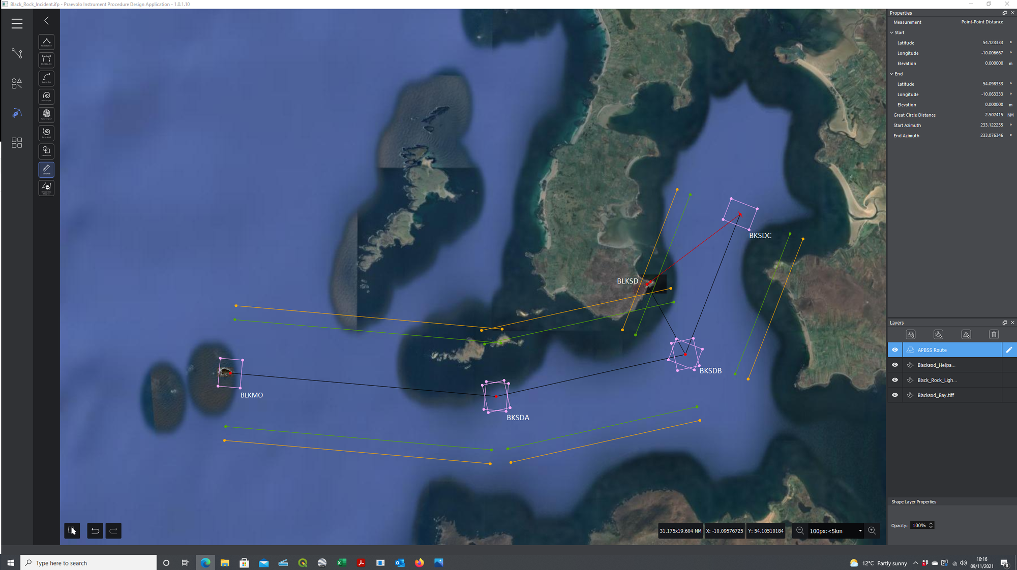
I can’t help but think the primary (out of many) causes of this horrendous incident is that it was not clear to anyone what the ‘Route APBSS (Blacksod South) actually was! I assume when the route was first produced pre 1999 it was meant as a visual low-level route (not a low-level IMC route!) for an S61 or similar, equipped with something like Decca based RNAV 1 or RNAV 2 which (as the report mentions) required an overfly of the start point (BKLMO) to confirm the navigation accuracy. I assume this would have started with an offshore let-down to a suitable height to gain visual references.
Back then, this was probably a sensible solution as there were no other real options for an instrument approach. What I can’t understand, and what to me is unforgivable, is that 18 years later, the Authorities have still not insisted that the ONLY acceptable method for general aviation helicopters (including SAR helicopters flying to/from regular use sites) to descend below MSA from IMC is via a properly designed and published instrument/PinS procedure.
From what I can see (I do not have access to the terrain or obstacle data for Ireland), you could easily have PinS approaches and departures both to/from the North East and West South/West which would have been more efficient and safer!
Out of interest, I drew the route on a Google Earth image (attached) with the RNP 0.3 (CAT H) waypoint fix tolerance areas (for anyone not into PBN, 0.3NM either side of track [that’s your RNP 0.3 so 95% of the time the GNSS says you are over the waypoint you should be in the pink rectangle] and 0.24NM before and after the waypoint). Also shown are the area semi-width areas in amber for a helicopter flying a route 1.45NM each side of track and in green for an aircraft on a STAR, SID, Initial Segment, Intermediate Segment or Missed Approach 1.15NM.
If drawn as a procedure, the route looks pretty flyable at MSA until BKSDB where the combination of establishing back on track after the turn and then turn anticipation for a rather interesting 148 degree turn at BKSDC is probably not doable in a distance of only 3.2NM.
Cheers
TeeS
...What I can�t understand, and what to me is unforgivable, is that 18 years later, the Authorities have still not insisted that the ONLY acceptable method for general aviation helicopters (including SAR helicopters flying to/from regular use sites) to descend below MSA from IMC is via a properly designed and published instrument/PinS procedure.
But it's seemingly OK to basically do that at night when stooging around the boonies at 200' when not on any IMC procedure and you can't even see 200' ahead of you. I kinda have a bit of difficulty trying to rationalize that.
On the night of the accident, R116 was tasked by MRCC Dublin to provide Top Cover for R118 and was using a ‘Rescue’ call sign; the IAA informed the Investigation that based on these two factors the flight was considered to be a SAR flight and, at the Commander’s discretion, could avail of the alleviations/exemptions contained in the National SAR Approval.
The CVR indicates that the Commander’s decision to go to Blacksod for fuel rather than Sligo was based on a concern to save thirty minutes flight time following R118 out, and also on the return journey; furthermore, the Commander received a report ‘conditions good at Blacksod’. The CVR indicates that the Commander later noted that reports from Blacksod indicated a cloud base as low as 300 ft and APP1 was used to bring the Helicopter down to 200 ft over open water before turning inbound to follow the APBSS route. This flight profile was in accordance with OMF which allows a minimum height of 200 ft with the helicopter’s collective axis coupled to RALT, and an absolute minimum of 50 ft helicopter hover with collective coupled to an AFCS SAR mode height hold.
However, OMF also requires visibility sufficient for the requirements of the task and to satisfy any OMB requirements for system modes being used. Although not a system mode requirement, OMB says ‘DVE is defined as visibility less than 4000 metres or no distinct natural horizon. Circuits shall be flown at 500 feet with reference to the RADALT with speed at least VY. Once established on the final approach track inside 2 nm at 500 feet, couple or remain coupled to RALT, HDG and IAS and beep down to 300 feet (or deck elevation plus 50 feet, whichever is the higher), to be level by around 1 nm to run.’
The Crew completed DVE Approach checks, indicating that they expected that they would be operating in DVE conditions. However, in descending to 200 ft, whilst it allowed the Crew to obtain COCISS conditions (clear of cloud, in sight of the surface), it eroded a safety barrier – height above the surface – without a definite improvement in terms of horizontal visibility. Furthermore, at 9 NM from Blacksod and 200 ft above sea level, operating just below the cloud base, at night, there were no external visual cues available (e.g. identifiable light sources or discernible features), to allow the Crew to assess horizontal/forward visibility.
I find it a bit disconcerting that the briefing for the descent/approach was not more `formalised` ,ie everyone on the same `Hymn-Sheet`, front and rear crew ,copies of the `route` and noting all the heights..nothing seemed to be mentioned.Consider also that the W/Op had been on the crew of R116 doing a similar sortie on 8 March just a few days earlier,and had `that big rock` pointed out by that crew`s W/Man,when it had been overflown on the departure from BLKSD at 900FT,as that crew initially decided on a flyover at 500ft,but then decided 900ft would be better.
I would have thought that on return there would have been crew-room chat/discussions about a sortie into an unfamiliar `patch`,and the procedures.
For ref; page 66,p 1.8.7,;8/3/17. of the Report....
I would have thought that on return there would have been crew-room chat/discussions about a sortie into an unfamiliar `patch`,and the procedures.
For ref; page 66,p 1.8.7,;8/3/17. of the Report....
They could still have used their 'legacy S61' approach quite safely but kept at 2400' until BLKMO, descended to 1000' by BKSDA then 200' by BKSDB - that would have kept them clear of terrain and allowed them to get beneath the cloudbase by the time there might have been something (lights etc) to see to assess the weather/vis before a simple left turn into BLKSD into wind once abeam and visual.
Yes, it was 01:00 and they had been up for a while but this was an experienced crew who seemed happy to 'do it they way we have always done it' rather than utilise the capabilities of the aircraft.
The profile they flew would have been safe using NVG - not ideal but safe enough - but unaided at night over the sea is IMC and you wouldn't dream of being below SALT unless you were on an approach (internal or external aids) to your LS.
I don't disagree with you Crab and if a SAR crew were responding to a vessel in the bay there, I realise that is the sort of process they would follow; however, in the absence of the 'low level route' I think it was unlikely that a crew would fly over an unexpected radar return at low level and I also suspect that the crew's arousal level would be higher in that situation than if they were following a known/reported route and missed one key piece of information, which is something we are all capable of doing.
My point is that Blacksod is a refuel point and as such is expected to be used on a regular basis, so there is no excuse for having to fly an ad-hoc IFR approach into it. The Authorities should be driving this forward for all operations where at the moment routine ad-hoc approaches are flown to regularly used sites, that includes corporate, SAR and HEMS in some areas.
Cheers
TeeS
TeeS - I agree and it highlights the complacency of the regulator and the operator in failing to ensure best practice.
Join Date: May 2016
Location: Exeter
Posts: 45
Likes: 0
Received 0 Likes
on
0 Posts
Originally Posted by [email protected]
there might have been something (lights etc) to see to assess the weather/vis
They were flying straight towards a lighthouse flashing every 12 sec - an intense source - which they neither saw nor caught the loom of.
To me this implies that the visibility at that position and height was far worse that the reports and may have been only a few metres. The lamp was only 82 feet above them.
Both as a pilot who once spent a fair amount of time flying around at 200 feet over the sea in some appalling weather, and as a ship's navigating officer, I am mightily puzzled.
Both as a pilot who once spent a fair amount of time flying around at 200 feet over the sea in some appalling weather, and as a ship's navigating officer, I am mightily puzzled.
This is something that has bugged me from the very beginning and rather pushes the question of NVG to one side.
They were flying straight towards a lighthouse flashing every 12 sec - an intense source - which they neither saw nor caught the loom of.
To me this implies that the visibility at that position and height was far worse that the reports and may have been only a few metres. The lamp was only 82 feet above them.
Both as a pilot who once spent a fair amount of time flying around at 200 feet over the sea in some appalling weather, and as a ship's navigating officer, I am mightily puzzled.
Join Date: May 2016
Location: Exeter
Posts: 45
Likes: 0
Received 0 Likes
on
0 Posts
I think the answer is that if you are not looking out of the window - because you are not expecting to see anything and you are heads in with FMS/radar etc - you won't see the lighthouse flash perhaps two or 3 times in that short period before you hit it.
Perhaps the weather was worse than expected and the lighthouse was in cloud - wearing NVG would have made that immediately obvious as you got to 200' in the letdown.
Perhaps the weather was worse than expected and the lighthouse was in cloud - wearing NVG would have made that immediately obvious as you got to 200' in the letdown.
I agree, although an additional factor is that the drift angle was 12˚L due to the wind from the rear right, so any light would have been offset to the left and not dead ahead. Ultimately, a contributory factor at best. CRM doesn't seem to be a major focus of the report especially around the approach briefing—unusual.
Last edited by ChristopherRobin; 10th Nov 2021 at 15:11.
Join Date: Jan 2003
Location: Europe
Posts: 13
Likes: 0
Received 0 Likes
on
0 Posts
My memory is of a ‘legacy’ route, initially created by Irish Helicopters to be used by the Bo105 servicing the Irish Lights contract. It’s purpose was to provide a ‘safe’ route between Blacksod and Blackrock Island, intended to be used for transit between both locations in poor weather conditions, subject to Day VFR regulations. At the time, flights at night could not be operated under VFR.
The ‘plate’ showed a magnetic track/reciprocal track and distance between each point on the route overlaid on the appropriate section of a VFR navigation chart. Each reference point was abeam an identifiable land feature. It pre-dated GPS and was flown on a time elapsed / dead reckoning basis. It was operated single pilot and without incident over the years although each pilot would have been very familiar with both the route and the topography of the area. It was never intended for navigation west of Blackrock Island.
Let us all remember that 4 people needlessly lost their lives in this accident. If it serves only 1 purpose, that is, if it causes you to examine more closely, to question and re-evaluate EVERY approach you consider making in ‘undetermined and unknown’ areas / conditions, then their sacrifice will not have been in vain.
Join Date: Jan 2001
Location: Galway
Posts: 84
Likes: 0
Received 0 Likes
on
0 Posts
Minister urged to accept all recommendations from R116 helicopter crash report