


No, not that QFE/QNH debate.

Thread Starter
Join Date: Apr 2015
Location: London, UK
Posts: 24
Likes: 0
Received 0 Likes
on
0 Posts
Having read a number of forum members getting quite aerated about their favoured altimeter setting, I'm anxious to stay well out of that argument.
However, I'm trying to find a reliable formula to convert a QNH to the QFE for an aerodrome for which I know the elevation. I figured that:
Your insights will be gratefully appreciated. Those wishing to debate the merits of QFE should (respectfully) look elsewhere*.
Cheers,
Z
*I'm told the expression these days is "jog on".
However, I'm trying to find a reliable formula to convert a QNH to the QFE for an aerodrome for which I know the elevation. I figured that:
QFE = QNH - (Elevation [in feet] / 3.2808399 [to convert to metres] * 0.12 [approx pressure reduction per metre at low level])
should be pretty good, but when I tried it for EGBJ (ARP elevation 101 feet) it gave me a QFE that was 4hPa (or millibars if you'd rather) lower than the QNH. Regular readers will know well that the QFE is normally given as 3hPa different. "No big deal", I hear you say - but whilst I can't fly with a level of accuracy that would make it a problem, I'd like to understand the difference. Is it that the threshold of the oft-used runways is really 6 feet lower than the ARP, or is there something important being left out of the formula? I read up a little bit about QFF, but it made my head go funny.Your insights will be gratefully appreciated. Those wishing to debate the merits of QFE should (respectfully) look elsewhere*.
Cheers,
Z
*I'm told the expression these days is "jog on".

Join Date: Apr 2019
Location: EDSP
Posts: 334
Likes: 0
Received 0 Likes
on
0 Posts
you are using the left arrow for your calculation where you should be using the right one. If you dug a hole at your airfield and sent your QNH set altimeter down, it would not necessarily show 0 at sea level, because it is using standard atmosphere.
I.e. You mustn�t use the geographic elevation but the density altitude above QNH of your airfield for conversion.
Last edited by BDAttitude; 4th Feb 2020 at 17:46.
Join Date: Feb 2009
Location: Do I come here often?
Posts: 898
Likes: 0
Received 0 Likes
on
0 Posts
If you are flying QFE or QNH why do you want to know the elevation in metres? Runway thresholds are often a different height AMSL than ARP's as the world isn't flat, instrument approach plates show threshold elevation, but approaches are still flown QNH. One aerodrome I fly to has 20/02 with 20 threshold 21' higher than 02. Sitting on the threshold at Kemble looking in one direction is like looking up a ski slope.
Don't over think it. If your preference is QFE or QNH circuits/landings the VFR flight guides tell you the circuit height/altitude to fly, do whichever is right for you. personally I think the QFE and Regional QNH have had their day.
SND
Don't over think it. If your preference is QFE or QNH circuits/landings the VFR flight guides tell you the circuit height/altitude to fly, do whichever is right for you. personally I think the QFE and Regional QNH have had their day.
SND
Rounding values
One other affecting part is that at least QNH is rounded down to the nearest whole hPa.
Calculation may give more than 3 hpa, but when its rounded down it comes closer to the QFE.
At lower levels it around 27 feet / hPa.
3.74 hpa, after rounding in most cases 3.
Does it have an instrument approach and does the threshold height differ from ARP ?
Edit:
Just looked at the plates:
Airport elevation 101’
Runway 27 = 87’
Runway 09 =. 74’
Problem solved.
Stop edit.
Try calling TWR and get both QFE and QNH in exact value ( including one tenth) and youll see :-)
Last edited by AAKEE; 4th Feb 2020 at 18:36.
Thread Starter
Join Date: Apr 2015
Location: London, UK
Posts: 24
Likes: 0
Received 0 Likes
on
0 Posts
you are using the left arrow for your calculation where you should be using the right one. If you dug a hole at your airfield and sent your QNH set altimeter down, it would not necessarily show 0 at sea level, because it is using standard atmosphere.
I.e. You mustn�t use the geographic elevation but the density altitude above QNH of your airfield for conversion.
p.s. Unless you're flying towards me
 , I think you may have got left and right reversed. As you point out, my calculation uses ISA (right) rather than reality.
One other affecting part is that at least QNH is rounded down to the nearest whole hPa.
Calculation may give more than 3 hpa, but when its rounded down it comes closer to the QFE.
At lower levels it around 27 feet / hPa.
3.74 hpa, after rounding in most cases 3.
Does it have an instrument approach and does the threshold height differ from ARP ?
Edit:
Just looked at the plates:
Airport elevation 101�
Runway 27 = 87�
Runway 09 =. 74�
Problem solved.
Stop edit.
Try calling TWR and get both QFE and QNH in exact value ( including one tenth) and youll see :-)
This has brought out a wicked thought; it's very tempting when inbound to ask a controller for the QFE by runway just to gauge their sense of humour. I suspect if it were a TWR, they'd have me orbiting for a few dozen minutes whilst they sent someone to measure it to the nearest Pascal for me.

All excellent and informative points - the last being the deal maker. I need to stop looking at the ARP and start looking at the threshold elevations.
This has brought out a wicked thought; it's very tempting when inbound to ask a controller for the QFE by runway just to gauge their sense of humour. I suspect if it were a TWR, they'd have me orbiting for a few dozen minutes whilst they sent someone to measure it to the nearest Pascal for me.
This has brought out a wicked thought; it's very tempting when inbound to ask a controller for the QFE by runway just to gauge their sense of humour. I suspect if it were a TWR, they'd have me orbiting for a few dozen minutes whilst they sent someone to measure it to the nearest Pascal for me.
When changing....edit wrote quicker than I thought,
Join Date: Apr 2019
Location: EDSP
Posts: 334
Likes: 0
Received 0 Likes
on
0 Posts

 .
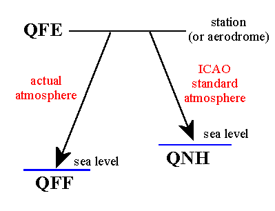
.The graphic is only stolen from the web. It misses which sea level is on the earths geoid (left) and which is virtual by calculation of the standard atmosphere (right). Only at an ARP at sea level they would have to be the same.

Join Date: Jun 2001
Location: Wherever someone will pay me to do fun stuff
Posts: 1
Likes: 0
Received 0 Likes
on
0 Posts
This has brought out a wicked thought; it's very tempting when inbound to ask a controller for the QFE by runway just to gauge their sense of humour. I suspect if it were a TWR, they'd have me orbiting for a few dozen minutes whilst they sent someone to measure it to the nearest Pascal for me.
The only cause for a short delay might be while the controller wonders what the heck you're asking for.......or maybe says to his/her colleagues 'You're not going to believe this, but....'.
Thread Starter
Join Date: Apr 2015
Location: London, UK
Posts: 24
Likes: 0
Received 0 Likes
on
0 Posts
@BD: I *think* I'm with you. Let's see: The elevation of EGBJ's ARP found in the AIP is its measured, geographic distance above actual, wet & salty, mean sea level. The sea level on which QNH is quoted isn't real in that its pressure of 1013.25hPa only occurs on a spherical earth at 15 degrees C in which UK is still in EU. Therefore, calculating QFE from QNH must consider where EGBJ would actually be if the world was a perfect, slightly lumpy sphere and it was warm outside - neither of which are true. Since this figure is not published in the AIP, I'm on a hiding to nothing.
However, if I want to create a model that gives more similar results to the real world, using the runway elevation instead of the ARP elevation will do the trick for EGBJ - and may or may not work for all the other airfields in UK..
@Beamer: You're right, but it makes me happy and keeps my head warm. In other news, my model for daytime temperatures using a 10 year monthly average min & max temps report and some cosines seems to work quite well. It was worth going to school after all.
@LookingForAJob: Thank you for that. The altimeters in the aircraft I fly give generalisations at best; Combined with my ham-fistedness, plus/minus a couple of hPa will make no difference at all to my circuit flying. Nice to know the tower is well-equipped though.
Last edited by ZG862; 5th Feb 2020 at 09:57.
The mere fact that you're trying to calculate a conversion from feet to metres in SEVEN (!) places of decimals (micrometers) while discussing differences between QFE and QNH in the order of six feet (two metres) tells me you really don't have a realistic grasp of what it is you're trying to do.
Fella, your altimeter doesn't/can't read to an accuracy better than 30-50ft or so - why on earth are you consideriing micrometers?
Fella, your altimeter doesn't/can't read to an accuracy better than 30-50ft or so - why on earth are you consideriing micrometers?
Join Date: Apr 2019
Location: EDSP
Posts: 334
Likes: 0
Received 0 Likes
on
0 Posts
@DB: I *think* I'm with you. Let's see: The elevation of EGBJ's ARP found in the AIP is its measured, geographic distance above actual, wet & salty, mean sea level. The sea level on which QNH is quoted isn't real in that its pressure of 1013.25hPa only occurs on a spherical earth at 15 degrees C in which UK is still in EU. Therefore, calculating QFE from QNH must consider where EGBJ would actually be if the world was a perfect,
The thing to take away is that QNH is just as field dependent as QFE is. Colder places will have smaller QNH than wormer places in the same air mass. Can be seen in the alps regularly.
Last edited by BDAttitude; 5th Feb 2020 at 06:44.
I think you're overcomplicating. The difference between QFE and QNH for a point at a particular elevation depends only on the standard atmosphere. That's because QNH is a hypothetical construct that makes an altimeter (which uses the ISA) read the elevation at that point. The number of hPa units you have to wind on to the subscale to change from 0 to the elevation does not depend on temperature. The diagram pictured above is correct. 28 ft per hPa around sea level is close enough.
At EGBJ, while the aerodrome has an elevation of 101 ft, the runways have threshold elevations between 73 and 89 ft. Hence 3 hPa difference between QNH and threshold QFE.
At EGBJ, while the aerodrome has an elevation of 101 ft, the runways have threshold elevations between 73 and 89 ft. Hence 3 hPa difference between QNH and threshold QFE.
Last edited by bookworm; 7th Feb 2020 at 14:38.
Join Date: Nov 2005
Location: Zulu Time Zone
Posts: 730
Likes: 0
Received 0 Likes
on
0 Posts
I'm trying to find a reliable formula to convert a QNH to the QFE for an aerodrome for which I know the elevation
30 feet per Millibar has worked well for the past 50 years
Getting back to reality, I see no need for QFE. It just causes problems when someone forgets to set QNH in the cruise, all altitudes are referenced to QNH, flight levels to 1013. When landing a simple bit of mental arithmetic gives you the height above the runway for the circuit etc. Runway is 220 ft AGL, circuit is 800 ft so fly the circuit at 1020 ft QNH - simple.

All excellent and informative points - the last being the deal maker. I need to stop looking at the ARP and start looking at the threshold elevations.
This has brought out a wicked thought; it's very tempting when inbound to ask a controller for the QFE by runway just to gauge their sense of humour. I suspect if it were a TWR, they'd have me orbiting for a few dozen minutes whilst they sent someone to measure it to the nearest Pascal for me.
Course if you used QNH you would find the minima for each i.a.p. is based on threshold elevation so you wouldn't end up with a plethora of pressure settings for the same airfield.
It's a few years since I researched these matters so please go steady if I'm out of date!
I believe in the UK that the published aerodrome elevation is the "highest point on the landing area" whereas in many States (ICAO definition?) the published aerodrome elevation is that of the Aerodrome Reference Point which is normally around the "middle" of the airport or main runway.
As has been stated previously the pressure is normally measured to one tenth of a Hpa but if ATC are passing a pressure setting it is corrected down to the nearest whole Hpa. E.g Pressure =1010.9 Hpa would be passed as 1010 Hpa - this would account for .9 X 27.3 = 25 feet as an "error" but on the "safe" side.
Thread Starter
Join Date: Apr 2015
Location: London, UK
Posts: 24
Likes: 0
Received 0 Likes
on
0 Posts
Thanks Bob. I read somewhere that in UK, NATS conventionally take the Aerodrome Reference Point as being in the middle of the aerodrome's longest runway.
I appreciate the further insights on rounding.
I appreciate the further insights on rounding.
No it's as bob says; the 'highest point on the landing area'. And it's the CAA not NATS.

