


Map Reading

Rule # 1 in Daze of Yore
First thing you did upon entry to your accommodation: Always grab a book of hotel matches and keep them with you. They all have the name, address and phone number on them. If lost and/or disorientated show them to the taxi driver, helpful doorman or annoyed police officer. Especially if there is a language problem.
First thing you did upon entry to your accommodation: Always grab a book of hotel matches and keep them with you. They all have the name, address and phone number on them. If lost and/or disorientated show them to the taxi driver, helpful doorman or annoyed police officer. Especially if there is a language problem.

Running out of maps
1992 two brothers took off from Vinon NE of Avignon and landed at Fez in an Ash glider. 1400+km. They had enough height for another 50km but had run out of maps. Iirc spent 2 days in prison not having taken their passports…
French video with English subtitles.
Last edited by blind pew; 30th Apr 2023 at 19:55. Reason: https://youtu.be/7KH7_UUkPXY

I still keep some maps in my car just in case my cell phone battery dies.
Call me a Luddite. There is also a very large park not too far away with meandering paths and iffy cell service, so I keep a map in my pocket so I don’t accidentally head off on a five or seven mile route when what I want is less than two miles.
Plus, some basic understanding of navigation is required, because in the USA, if you are not careful, when you enter the name of a town into a map app, you can be sent to a different STATE from the one you planned to visit. A hilarious mistake to view, assuming you don’t blindly follow directions.
As the Syrian lorry driver transporting luxury cars from Turkey to Gibraltar found out in 2008 when he was sent on a 1600 mile detour to Skegness by his satellite navigation system. Birdwatchers at Gibraltar Point looked on in astonishment as Necdet Bakimci tried to steer his 32-tonne lorry down a narrow lane towards the North Sea....
Last edited by BEagle; 1st May 2023 at 07:33.
BP, What an amazing flight. Thank you so much for posting that video.
The following 2 users liked this post by Bergerie1:
Disco , sorry to disagree ... 12 yrs on Trids , Doppler map pretty good ... didn't like calm seas , or if you brought the wrong roller strip map !
Needed a reset every now and then from a VOR/D , and would not have used it for an approach . Doppler drift and G/S from same source also V useful .. especially on instrument apps . Consol still pretty good up and down N.Sea when too far from Dover or Kristiansand . Seem to remember 212 DME max.
B732s with Doppler drift and G/S not so good , rumour was they were cheap and for helos [ max speed 200kts ] .
GPS v good for detail , car or a/c .. map/chart for big piccy , with N up !
rgds condor .
Disco , sorry to disagree ... 12 yrs on Trids , Doppler map pretty good ... didn't like calm seas , or if you brought the wrong roller strip map !
Needed a reset every now and then from a VOR/D , and would not have used it for an approach . Doppler drift and G/S from same source also V useful .. especially on instrument apps.
rgds condor .
Needed a reset every now and then from a VOR/D , and would not have used it for an approach . Doppler drift and G/S from same source also V useful .. especially on instrument apps.
rgds condor .
IIRC the moving map kit included a stylus for recording track achieved but again I never saw it in use.
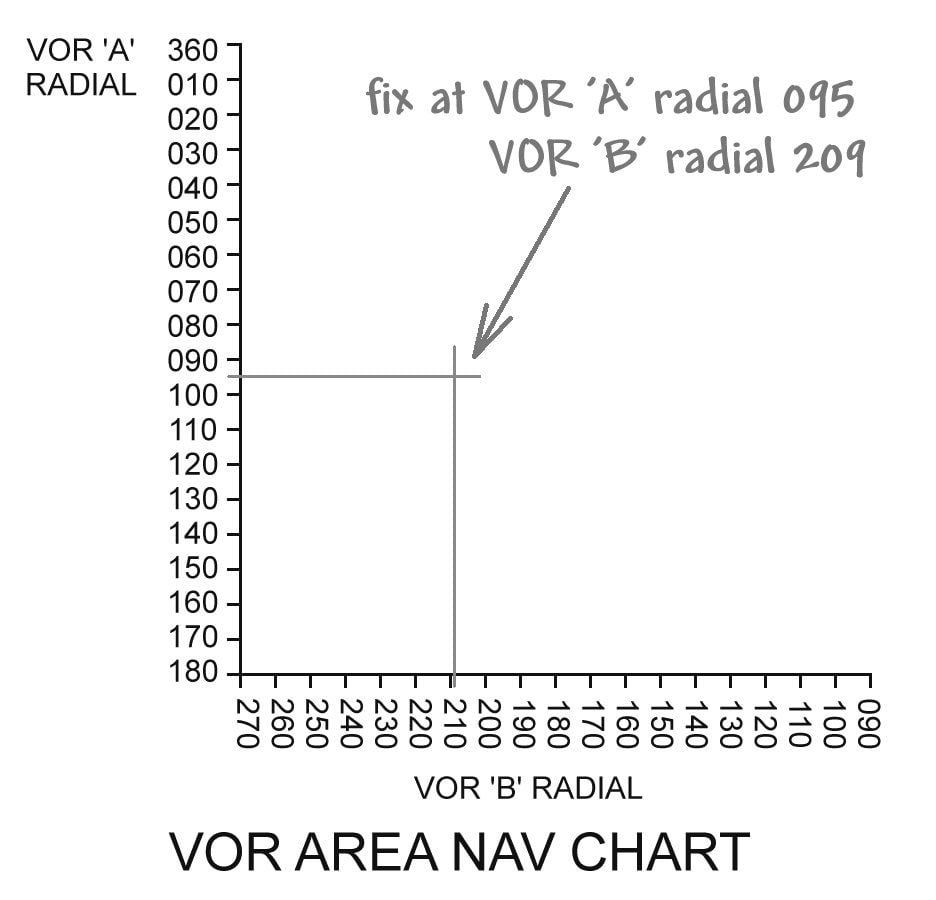
The 1970s VOR 'area nav' charts were compiled by Ernst Stogmuller and Gordon Wansbrough-White (mock-up below). Limited use due to distortion and also inaccuracy when the radials intercepted at a shallow angle.
Join Date: Feb 2006
Location: Hanging off the end of a thread
Posts: 33,002
Received 2,893 Likes
on
1,238 Posts
I remember rebuilding an aircraft for a French gentleman, he was heading to somewhere north west of Paris but it was fogged in so he diverted somewhere else... Anyway, the long and short of it, he became lost and found himself low on fuel, so descended through the layer looking for somewhere to put it down and managed to pull of a landing in a plowed field along the furrows without any damage.
Welcome to Kent ... the problem then came as to how they would lift it out of the field and the USAF came to the rescue with a CH-53 doing it as a training exercise, it all was going swimmingly until the Sea Stallion arrived and the poor little thing was blown over onto its back crushing the arse end, that is where I became involved, we sourced the back end off one from a US breakers yard and nailed it together.
Welcome to Kent
... the problem then came as to how they would lift it out of the field and the USAF came to the rescue with a CH-53 doing it as a training exercise, it all was going swimmingly until the Sea Stallion arrived and the poor little thing was blown over onto its back crushing the arse end, that is where I became involved, we sourced the back end off one from a US breakers yard and nailed it together.
Nutty
Spookily, I have witnessed that event happening at an airshow in Germany when I was the display crewman on the Puma. I think it was Breitscheid, about 50km east of Bonn. Our heroes entered and settled into the hover, only to flip at least 2 puddle jumpers on their backs. Now enter the anti-hero whose initials were George and Blackie (RIP), who politely enquired, "Don't they teach you cluckers that downwash goes downwind then?"
Spirited reply, "It's only a Cat C mishap- less than $100,000 to fix. It'll be fine. Beer anyone?"
CG
PS, the small airfield Germans were always wonderful hosts.
Spirited reply, "It's only a Cat C mishap- less than $100,000 to fix. It'll be fine. Beer anyone?"
CG
PS, the small airfield Germans were always wonderful hosts.
As the Syrian lorry driver transporting luxury cars from Turkey to Gibraltar found out in 2008 when he was sent on a 1600 mile detour to Skegness by his satellite navigation system. Birdwatchers at Gibraltar Point looked on in astonishment as Necdet Bakimci tried to steer his 32-tonne lorry down a narrow lane towards the North Sea....
Nutty
Spookily, I have witnessed that event happening at an airshow in Germany when I was the display crewman on the Puma. I think it was Breitscheid, about 50km east of Bonn. Our heroes entered and settled into the hover, only to flip at least 2 puddle jumpers on their backs. Now enter the anti-hero whose initials were George and Blackie (RIP), who politely enquired, "Don't they teach you cluckers that downwash goes downwind then?"
Spirited reply, "It's only a Cat C mishap- less than $100,000 to fix. It'll be fine. Beer anyone?"
CG
PS, the small airfield Germans were always wonderful hosts.
I regret to say the best I have encountered, far and away, was in a Tesla.
I've handled various cars with inbuilt GPS, ranging from passable to appalling.
A German colleague and I once hired a car at Hamburg airport. As soon as he fired it up, the SatNav pointed directly to Poland, so I asked in mock innocence whether there was any particular reason for that - was it historical? After fiddling for a couple of minutes, he entered our destination hotel and off we went. He knew a better route once we were over the Elbe, but the SatNav wanted us to go a different way... A few "Bitte biegen Sie nach 500 Metern rechts ab" and the like in a polite female voice, with increasing urgency as we got closer to her preferred turning, until 'she' suddenly shrieked "JETZT RECHTS!" like some whip-wielding Brunhilde from a sex dungeon*. As we went past, there was a pause before she sulkingly announced "Neu berechnen" in such an annoyed tone that had us laughing aloud.
* or so I understand - but not from personal experience!
I also use a Garmin 600 and generally, find it pretty good.However, last week I was driving to an interstate address, but couldn't enter it until I was actually in that state. Instead, I used Apple Maps on my phone, which worked perfectly. I do like the way the Nuvi tells me about any delays on my route, though.
Indeed! But my trusty Garmin n�vi 600 always travels with me and has never let me down.
A German colleague and I once hired a car at Hamburg airport. As soon as he fired it up, the SatNav pointed directly to Poland, so I asked in mock innocence whether there was any particular reason for that - was it historical? After fiddling for a couple of minutes, he entered our destination hotel and off we went. He knew a better route once we were over the Elbe, but the SatNav wanted us to go a different way... A few "Bitte biegen Sie nach 500 Metern rechts ab" and the like in a polite female voice, with increasing urgency as we got closer to her preferred turning, until 'she' suddenly shrieked "JETZT RECHTS!" like some whip-wielding Brunhilde from a sex dungeon*. As we went past, there was a pause before she sulkingly announced "Neu berechnen" in such an annoyed tone that had us laughing aloud.
* or so I understand - but not from personal experience!
The following users liked this post:
Join Date: Mar 2010
Location: Often in Jersey, but mainly in the past.
Age: 79
Posts: 7,812
Received 137 Likes
on
64 Posts
Unlike my first ever experience with Google Maps in PHX on my shiny new iPhone ...
"Then the voice says it’s “24th Street, left at the traffic signals onto Sky Harbor Circle” and finally “Take 2nd left to the Rental Centre”. I obey the latter command, across the wide expanse of 4 traffic lanes, to be confronted by a large No Entry sign and 2 vehicles pointing at me. Thanks, Google Maps and talking brick … this is the bloody EXIT from the Rental Center!! Deep breath, reverse carefully across 3 traffic lanes [glad it’s quiet] and find the Entrance to the Rental Center a hundred yards or so further on. Phew!"
"Then the voice says it’s “24th Street, left at the traffic signals onto Sky Harbor Circle” and finally “Take 2nd left to the Rental Centre”. I obey the latter command, across the wide expanse of 4 traffic lanes, to be confronted by a large No Entry sign and 2 vehicles pointing at me. Thanks, Google Maps and talking brick … this is the bloody EXIT from the Rental Center!! Deep breath, reverse carefully across 3 traffic lanes [glad it’s quiet] and find the Entrance to the Rental Center a hundred yards or so further on. Phew!"
Wanted to travel from North Wales to Liverpool.
New the way, but not the final bit in Bootle.
Put in the postcode and off I went.
Satnav wanted me to travel west and not north, so I continually ignored it. Eventually the directions made sense and I arrived at correct destination.
Intrigued, I went into settings to work out what was going wrong.
It was setup for the shortest distance. Ruthin to Holyhead, ferry from Holyhead to Dublin, ferry from Dublin to Liverpool then Liverpool to Bootle!
The following users liked this post:
1972 up front on a Carvair ex Rochford airport where they had a decca driven map which they used for approaches to down to 300ft into Le Touquet and Lympe.
Had decca on a yacht but when I needed it one time useless due to signal coverage.
Bought the first hand held GPS but sailing off the Essex coast near the military ranges in poor visibility through the swatchways when it indicated up to 56 knots..afterwards read about gps interference originating from military sources.
Hacked a Kobo e-reader with a gps/vario chip which was easily readable in bright sunlight due to liquid paper. Used it in track orientation display but one time I thought it was on the blink as the terrain didn’t match the display until I realised I was flying backwards towards the mountain (with respect to the ground in case of smart Alec’s).
Most alarming was on the very new F100 with an electronic cockpit and relying on the display instead of charts…dirty descent into Sofia during the break up of Yugoslavia on an unfamiliar routing to a VOR approach..ding ding..display goes blank..company had bought the cheap version driven by two DMEs without an inertial platform..dropped out if it didn’t have the required signals or if they were on the same relative bearing.
As to the gripper argument..no comment. ;-)
Wanted to travel from North Wales to Liverpool.
New the way, but not the final bit in Bootle.
Put in the postcode and off I went.
Satnav wanted me to travel west and not north, so I continually ignored it. Eventually the directions made sense and I arrived at correct destination.
Intrigued, I went into settings to work out what was going wrong.
It was setup for the shortest distance. Ruthin to Holyhead, ferry from Holyhead to Dublin, ferry from Dublin to Liverpool then Liverpool to Bootle!
New the way, but not the final bit in Bootle.
Put in the postcode and off I went.
Satnav wanted me to travel west and not north, so I continually ignored it. Eventually the directions made sense and I arrived at correct destination.
Intrigued, I went into settings to work out what was going wrong.
It was setup for the shortest distance. Ruthin to Holyhead, ferry from Holyhead to Dublin, ferry from Dublin to Liverpool then Liverpool to Bootle!