


Mag, Grid & True North Align

"f you want to be ultra-pessimistic read Jim Al Khalili's book "Sunfall" which postulates a coronal mass ejection hitting Earth just at the point when the magnetic field passes through a temporary zero. "
highly nlikley - the mag field reversal is quite common (in geological terms ) often less than 100,000 years apart
highly nlikley - the mag field reversal is quite common (in geological terms ) often less than 100,000 years apart

Do other countries have national grids? I’ve got some rather beautiful 50thou maps of the Pyrenees by the IGN (French OS equivalent). They match the OS as maps of quality. The only grid overlay is WGS84 with 4 km squares and no info on magnetic North and not an isogonal in sight. It’s obviously designed to be used with GPS (Compatible GPS/WGS84) gives that away!
Nice video from OSGB, explaining the concepts:
As Timelord pointed out earlier, on the UK National Grid, True North and Grid North are only coincident at 2� W, because this is the Central Meridian of the projection.
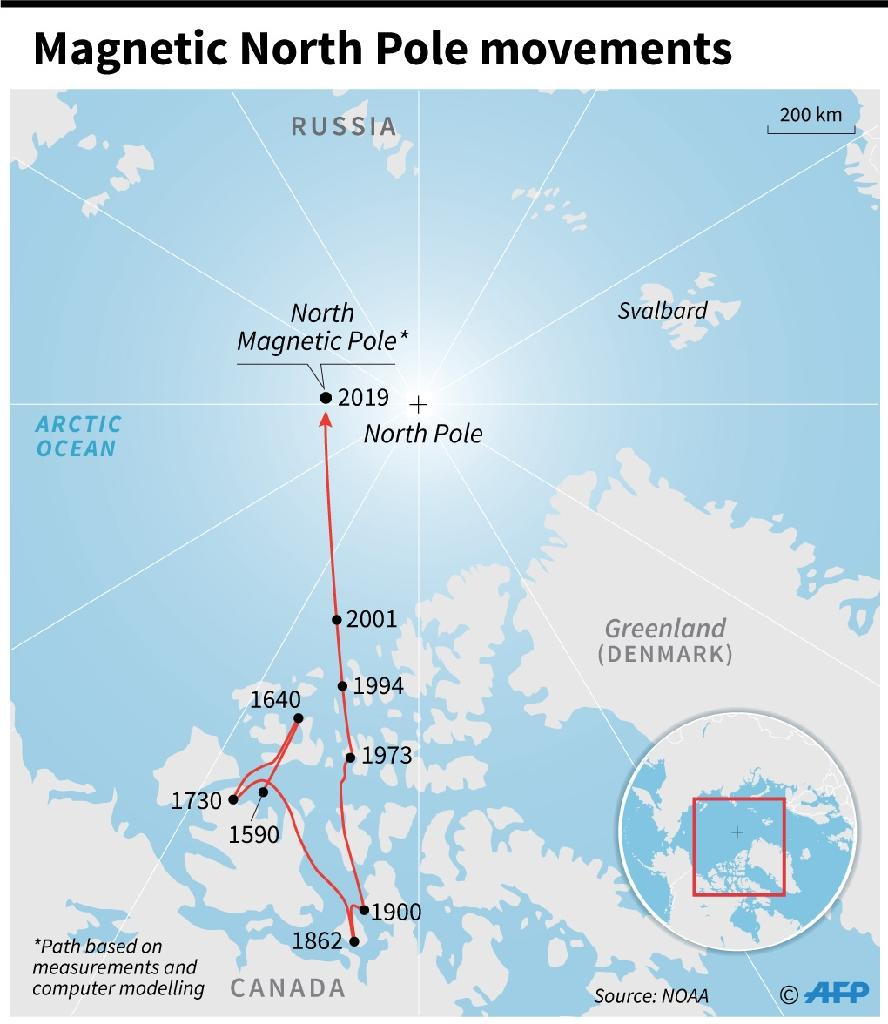
For most of the last 400 years, the North Magnetic Pole has been wandering around the Canadian Arctic, but 30 years ago it started moving fast towards Russia.
PS Having posted a video link, it turns out I can’t see it in my post. This is a common complaint on PPRuNe these days.
A quick way to see the link is to click on the Quote button below, which will allow you to see and copy the video link.
As Timelord pointed out earlier, on the UK National Grid, True North and Grid North are only coincident at 2� W, because this is the Central Meridian of the projection.
For most of the last 400 years, the North Magnetic Pole has been wandering around the Canadian Arctic, but 30 years ago it started moving fast towards Russia.
PS Having posted a video link, it turns out I can’t see it in my post. This is a common complaint on PPRuNe these days.
A quick way to see the link is to click on the Quote button below, which will allow you to see and copy the video link.
Last edited by Senior Pilot; 7th Nov 2022 at 02:03. Reason: Fix YouTube link
Do other countries have national grids? I�ve got some rather beautiful 50thou maps of the Pyrenees by the IGN (French OS equivalent). They match the OS as maps of quality. The only grid overlay is WGS84 with 4 km squares and no info on magnetic North and not an isogonal in sight. It�s obviously designed to be used with GPS (Compatible GPS/WGS84) gives that away!
I think most other countries� 50k s have a UTM grid.
TL
With the ever changing magnetic North does this mean that at any time in the near future we will see 27R and 27L revert to 28R and 28L? I remember it changing sometime in the 1970s and surely with the ever changing magnetic North it should change back at some point.
"f you want to be ultra-pessimistic read Jim Al Khalili's book "Sunfall" which postulates a coronal mass ejection hitting Earth just at the point when the magnetic field passes through a temporary zero. "
highly nlikley - the mag field reversal is quite common (in geological terms ) often less than 100,000 years apart
highly nlikley - the mag field reversal is quite common (in geological terms ) often less than 100,000 years apart
And given the long duration of reversals, this present faster movement of the magnetic poles and the weakening of the magnetic filed are likely indicators that the end of this chron is nigh, and reversal is already starting to take place.
One snag that took a bit of working out was that if you did a radar update using a ground feature, the NAVHARS always gave a position error of 360/999nm and if you accepted the fix, the kit immediately went TU. We discovered that it hadn’t been programmed to cope with the southern hemisphere and always updated to the corresponding position in the northern hemisphere!
Made us larf!
Mog

"As these pole reversals can take many thousands of years,"
Some seem pretty short - less than 2000 years IITC - as humanoids have existed on earth through several reversals without disappearing I'd guess it's a low risk - tho we may see more in the way of cancers caused by higher radiation levels
Some seem pretty short - less than 2000 years IITC - as humanoids have existed on earth through several reversals without disappearing I'd guess it's a low risk - tho we may see more in the way of cancers caused by higher radiation levels
Soviet grids are northings/eastings as well. They're in common usage in Eastern Europe incl Ukraine.
Mag2True
There is a team actively working on moving the entire aviation system to True. Canada is shifting its entire airspace to True in 2030 and ICAO has just surveyed state responses to the idea of a global change.
Industry spends ~$2Bn per 5 year magnetic model on keeping up with the movement of the N pole. It used to be a 10 year epoch but the pole is moving too fast now. Cost of change is about $10K per stop bar.
IFPs are designed in True and converted to Mag for display because that is what ICAO decided in 1948, when an inertial navigation system was someone who slept in the rear cockpit. PNT information is derived in True, very accurately, then converted to Mag by using declination values that could be 5 or more years old.
Nav Canada has already done proving flights to show that zeroing the aircraft INS look up tables works seamlessly. The alternative is to simply select True on the relevant switch.
Fewer runways and aids need updating in Europe than could be left as is. Agreed, there is a one time cost for the infrastructure but then nothing for changes TFN.
Why aren�t we doing this now?
The global axis is wobbling , hence the increase in daylight in the Arctic . One of the hunters we flew mentioned the extra daylight in the North . We thought he was just displaying cabin fever . The increase in wobble may be caused by the weight shift caused by mining and moving billions of tons of ore around the world since industrialization began . Like changing the lead balance weights on a wheel . The movement of all those weights may have an effect of the harmonic resonance of this spinning oblique spheroid . To counter the effects of these changes I would humbly suggest we all stand on one foot for twenty minutes per day . Standing on one foot for twenty minutes a day might not mitigate the effects of harmonic resonance change , but might have the same effect as carbon trading has in preventing climate changes 
As PAXboy noted the earth is an oblate spheroid - but only just. 
WGS-84, used as the default spheroid by GPS, has an equatorial diameter of 12,756 km. The polar diameter is 43 km less - a difference of 0.3%.
I remembered a similar problem with a flight of F-22s crossing the dateline on their way to Japan:
F-22 Software glitch
I once worked for a Canadian oil company that started doing exploration work in places other than North America. Their computer-mapping system not only couldn't cope with anywhere south of the equator, but it assumed, for convenience, that all positive Longitudes were west of Greenwich!
A colleague of mine who was assigned to fix this problem, created a test file to make sure the new program was always correct, even after modifications. It consisted of four short seismic lines with True azimuths of 360, 045, 090 and 135. They intersected each other, at the Equator and the Greenwich Meridian.
WGS-84, used as the default spheroid by GPS, has an equatorial diameter of 12,756 km. The polar diameter is 43 km less - a difference of 0.3%.
F-22 Software glitch
I once worked for a Canadian oil company that started doing exploration work in places other than North America. Their computer-mapping system not only couldn't cope with anywhere south of the equator, but it assumed, for convenience, that all positive Longitudes were west of Greenwich!
A colleague of mine who was assigned to fix this problem, created a test file to make sure the new program was always correct, even after modifications. It consisted of four short seismic lines with True azimuths of 360, 045, 090 and 135. They intersected each other, at the Equator and the Greenwich Meridian.
Last edited by India Four Two; 7th Nov 2022 at 00:40.
"The increase in wobble may be caused by the weight shift caused by mining and moving billions of tons of ore around the world since industrialization began"
No its a long term effect that seems to originate in the Earth's core -
No its a long term effect that seems to originate in the Earth's core -
Originally Posted by Mogwi View Post
We discovered that it hadn’t been programmed to cope with the southern hemisphere and always updated to the corresponding position in the northern hemisphere!
Made us larf!
Mog
We discovered that it hadn’t been programmed to cope with the southern hemisphere and always updated to the corresponding position in the northern hemisphere!
Made us larf!
Mog