


LONG RANGE SAR


Join Date: Aug 2004
Location: The US of A, and sometimes Bonnie Scotland
Posts: 549
Likes: 0
Received 0 Likes
on
0 Posts

Join Date: Mar 2014
Location: Earth
Posts: 2
Likes: 0
Received 0 Likes
on
0 Posts
For Captain radar...
"John Young of Amsa said planes were "flying relatively low" with "very highly skilled and trained observers looking out of the aircraft windows... to see objects"."
I'm sure the "very highly trained observers" would be really happy by your statement.
Gentlemen, you misunderstand me. Probably my fault. John Young said what I said, and if you read it again I said TRAINED observers. The same trained observers that operate the P8 and all other MPA. Those of you that have spent as many hours as I have as a trained observer looking for lost vessels/people/aircraft in the ocean will understand that we used every tool in the box to try and locate whatever we were looking for. If it was something low in the water, or of low radar cross section we used windows. (Mind you, whatever we were looking for we looked out of the windows!) Perspex windows with trained professional observers. I just don't think the P8 has many windows and the trained professional operators could do with more of them. If they are looking for bits of carbon fibre, floating fuselage section, seat cushions, dinghies etc they need more windows. That's all. Utter Pish? Insulting the crews? No, not at all. Maybe the kit is that much better now. I hope so, but I bet it's not optimised to work at visual search heights, why would it be? The P8 itself isn't optimised to operate there, and that was my point. Sorry if I didn't make it very well.
And the P-8 handles great down low.
Join Date: Jul 2010
Location: cardboard box in't middle of t'road
Posts: 745
Likes: 0
Received 1 Like
on
1 Post
I'm willing to bet a skilled EWO operator will find debris before the eye of an observer will.
You'd think that EO would be able to pick up debris first, but it rarely happens like that. Using EO is like looking down a drinking straw, it's very good for seeing large objects that are far away, once you are queued on by either Radar or AIS. Once acquired, the object can be held in view to the on top. Even using the wider fields of view it is very difficult to acquire smaller objects, observers usually see the smaller objects first, either on the flight deck or in the observer stations. EO will be used for the search, as it is an extra set of eyes, but the MK1 eyeball is hard to beat.
Join Date: Jan 2009
Location: S of 55N
Posts: 360
Likes: 0
Received 0 Likes
on
0 Posts
Surplus said:
State of the art EO/IR has moved on. Google 'step-stare'. I don't know if the P8 has step-stare (I would hope it does however) but, having used it myself I can say that it's a leap beyond 'traditional' EO/IR in terms of being able to cover large areas (with confidence).
The issue isn't that targets don't show up on a (traditional) EO/IR sensor, it's that then human eye is poor at picking it out of the clutter and confusion. Step-stare is a significant improvement in that regard.
Sun.
Edited to add:
e.g. (and this is not a high-end example)
A lightweight EO payload, WESCAM 11SST (Step-Stare Turret) offers a unique capability to rapidly cover a large area with is its “step-stare” function. The payload is equipped with gimbaled, tri-sensor stabilized bench designed for high speed step-stare functioning (>120deg./sec slew rate). The sensor captures seven video frames per second, images are compressed and streamed to the control station, where they are tiled together to create a hi-resolution digital image of a large area. 11SST covers up to 300sq kilometers per hour, from an altitude or distance of 4,000meters.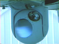
The payload can accommodate an optional geo-positioning and image processing package for flexible automatic positioning and automatic target tracking. The payload is equipped with 3rd generation 3-5nm InSb FLIR, a color daylight CCD sensor with x14 zoom lens (2.2-28.5mm) and an eyesafe laser rangefinder.
Using EO is like looking down a drinking straw, it's very good for seeing large objects that are far away, once you are queued on by either Radar or AIS.
The issue isn't that targets don't show up on a (traditional) EO/IR sensor, it's that then human eye is poor at picking it out of the clutter and confusion. Step-stare is a significant improvement in that regard.
Sun.
Edited to add:
e.g. (and this is not a high-end example)
A lightweight EO payload, WESCAM 11SST (Step-Stare Turret) offers a unique capability to rapidly cover a large area with is its “step-stare” function. The payload is equipped with gimbaled, tri-sensor stabilized bench designed for high speed step-stare functioning (>120deg./sec slew rate). The sensor captures seven video frames per second, images are compressed and streamed to the control station, where they are tiled together to create a hi-resolution digital image of a large area. 11SST covers up to 300sq kilometers per hour, from an altitude or distance of 4,000meters.
The payload can accommodate an optional geo-positioning and image processing package for flexible automatic positioning and automatic target tracking. The payload is equipped with 3rd generation 3-5nm InSb FLIR, a color daylight CCD sensor with x14 zoom lens (2.2-28.5mm) and an eyesafe laser rangefinder.
Last edited by Sun Who; 30th Mar 2014 at 07:43. Reason: New info.
Join Date: Mar 2014
Location: Earth
Posts: 2
Likes: 0
Received 0 Likes
on
0 Posts
EWO? I'm assuming you mean an EO operator?
Most search is done between 1,500 ft and 5,000 ft. It's not like the old days where you might be able to point something out at 200 ft.
Join Date: Jul 2006
Location: by the Great Salt Lake, USA
Posts: 1,542
Likes: 0
Received 0 Likes
on
0 Posts
Except that in the current search the P-8 has been flying as low as 200' (according to persons who were aboard), in part because atmospheric conditions require it, as >500 feet meant neither the eye nor the EO sensor could see anything.
before we all go shouting "technology has the answer" just remember not a single sensor ever identified anything, -
and before you all go spluttering a reply let me finish the sentence - a competent operator is the one who identified what the sensor may have detected. Regardless of sensor...
I await the onset of 'automatic detection' examples - all capable of being proved wrong.
and before you all go spluttering a reply let me finish the sentence - a competent operator is the one who identified what the sensor may have detected. Regardless of sensor...
I await the onset of 'automatic detection' examples - all capable of being proved wrong.
Agreed HAS 59. Automation is always being pushed as a means for "saving" human search effort (i.e. direct and indirect costs).
In the last century I came across certain European scientists taking development money for this in support of searches of large areas of Commercial Satellite Imagery. Egged on by petty bureaucrats and bean counters, their mandate was for the entire search system "soon" to be automated and us Imagery Interpreters and Analysts replaced. Apparently this would be with easily recruitable and comparatively untrained data loaders and typing clerks at, of course a great cost saving. This process was always phrased as being "more efficient" of course.
The scientists ( none of whom had an imagery intelligence background, of course - perish the thought) proudly brought their prize software down to our" Centre in the Sun" to educate my Ops. Division as to the way ahead. In front of us all they were soon keen to demonstrate its capability to follow along a road on a Satellite Image. This it did for a few minutes. Unfortunately in the course of the tracking demo, the road took a sharp 90 deg bend.
The "intelligent" system didn't, however, and continued to track ahead, first along a hedgerow, then it hit a stream etc. etc.....
I got that spec knocked back to being for a support tool only after that one.
I'd love to see such kit deal with interpreting a stream of hundreds of multiple images , in negative and often inverted , plus IR , plus SLAR and all against minutes on the clock as was done by First Phase operators back in the 70's ( Who of course would also be simultaneously dictating a Recce report and evaluating the imaging runs with one or more tired and often impatient aircrew).
Incidentally, In those days NATO 1st Phase Reconnaissance report production output timing standards from "engines off" were 50% slower than those national standards of the U.K.
In mitigation, such soft-wares DO have a potential in change detection and in ploughing through redundant data to alert a human to anomalies for investigation . However noise and other confusing factors cannot always be successfully countered. We can't phase out the driver of the intelligently driven eyeball ( the Mk2 ) just yet, over land or sea, who can adapt and apply situational awareness to the task(s) at hand.
In the last century I came across certain European scientists taking development money for this in support of searches of large areas of Commercial Satellite Imagery. Egged on by petty bureaucrats and bean counters, their mandate was for the entire search system "soon" to be automated and us Imagery Interpreters and Analysts replaced. Apparently this would be with easily recruitable and comparatively untrained data loaders and typing clerks at, of course a great cost saving. This process was always phrased as being "more efficient" of course.
The scientists ( none of whom had an imagery intelligence background, of course - perish the thought) proudly brought their prize software down to our" Centre in the Sun" to educate my Ops. Division as to the way ahead. In front of us all they were soon keen to demonstrate its capability to follow along a road on a Satellite Image. This it did for a few minutes. Unfortunately in the course of the tracking demo, the road took a sharp 90 deg bend.
The "intelligent" system didn't, however, and continued to track ahead, first along a hedgerow, then it hit a stream etc. etc.....
I got that spec knocked back to being for a support tool only after that one.
I'd love to see such kit deal with interpreting a stream of hundreds of multiple images , in negative and often inverted , plus IR , plus SLAR and all against minutes on the clock as was done by First Phase operators back in the 70's
( Who of course would also be simultaneously dictating a Recce report and evaluating the imaging runs with one or more tired and often impatient aircrew). Incidentally, In those days NATO 1st Phase Reconnaissance report production output timing standards from "engines off" were 50% slower than those national standards of the U.K.
In mitigation, such soft-wares DO have a potential in change detection and in ploughing through redundant data to alert a human to anomalies for investigation . However noise and other confusing factors cannot always be successfully countered. We can't phase out the driver of the intelligently driven eyeball ( the Mk2 ) just yet, over land or sea, who can adapt and apply situational awareness to the task(s) at hand.
Last edited by Haraka; 31st Mar 2014 at 16:26.
Join Date: Aug 2004
Location: The US of A, and sometimes Bonnie Scotland
Posts: 549
Likes: 0
Received 0 Likes
on
0 Posts
Join Date: Jul 2010
Location: cardboard box in't middle of t'road
Posts: 745
Likes: 0
Received 1 Like
on
1 Post
Bannock,
The Bacon and Egg rolls always go down well on our crew, as does the chicken with mayo for the sandwiches. George Foreman always comes along on Detachments.
500N,
The support/accommodation facilities at Pearce must be close to being at max stretch with the number of extra people involved in the search.
Flight rationing at Pearce is shocking.
500N,
Anyone know why the P-8 and the Chinese aircraft are operating out of Perth International and not RAAF Pearce ?

Join Date: Jan 2008
Location: Australia - South of where I'd like to be !
Age: 59
Posts: 4,261
Likes: 0
Received 0 Likes
on
0 Posts
Yes, good point, forgot about that part.
I think Abbott said 550 people involved at RAAF Pearce !!!
I supposed RAAF Pearce is normally used to the "Chicken stranglers"
as opposed to people who want decent beds
I think Abbott said 550 people involved at RAAF Pearce !!!
I supposed RAAF Pearce is normally used to the "Chicken stranglers"
as opposed to people who want decent beds
Join Date: Jun 2008
Location: lancaster
Posts: 6
Likes: 0
Received 0 Likes
on
0 Posts
As seen on Sky News - RAF SEEDCORN personnel help in the search for MH 370 Malaysia Plane Probe Focuses On Crew And Pilots
About half way through the video 2 guys from the RAF are seen getting on board a P3C and interviewed. Sorry if this has been posted elsewhere.
About half way through the video 2 guys from the RAF are seen getting on board a P3C and interviewed. Sorry if this has been posted elsewhere.
Join Date: Nov 2013
Location: Australia
Posts: 6
Likes: 0
Received 0 Likes
on
0 Posts
Anyone know why the P-8 and the Chinese aircraft are operating out of Perth International and not RAAF Pearce ?