


 2nd Mar 2020, 14:35 - Wikipost
|
|||
|
|||
 Thanks to Self Loading Bear for suggesting that we use a wiki.
Which Aerodrome Mk III
They look like P-61's along the side of the strip. A Commonwealth connection could take us to New Guinea


Are you talking about your post ~18482?
If so I think you've got the wrong end of the stick - he/she said" Not Tabitauea (North or South) . Neither is or has been, to my knowledge, an international airport." - he was referring to the guess by DESCOL # 18475 I take it it IS an international l airport but not v big.....................
If so I think you've got the wrong end of the stick - he/she said" Not Tabitauea (North or South) . Neither is or has been, to my knowledge, an international airport." - he was referring to the guess by DESCOL # 18475 I take it it IS an international l airport but not v big.....................
Join Date: Dec 2011
Location: herts
Posts: 1,838
Likes: 0
Received 0 Likes
on
0 Posts
I think the "I am often accused of being a pedant" is a big clue and leads to Mullinix Field at the other end of the island to Hawkins Field - same location as Max Tow suggested with Bonriki.
Join Date: Aug 2008
Location: dublin
Age: 74
Posts: 823
Likes: 0
Received 0 Likes
on
0 Posts
Last edited by descol; 24th Feb 2020 at 14:27. Reason: spelling
Join Date: Dec 2002
Location: Melbourne Australia
Posts: 308
Likes: 0
Received 0 Likes
on
0 Posts
BONRIKI
Mullinix in the war times but now Bonriki on South Tarawa, Soon to be home to a couple of aircraft built by a company started by an ex Brazilian military ATC. The first aircraft is currently at an airfield very close to another old wartme strip to which 16ALA moved in 1973,
Max has declared OH.
Dook chased around the atoll with Hawkins (now Betio, but no more an airport) and then Bairiki where there has never been a runway - I carefully considered if he'd made a typo but decided not - pity he did not continue 22kn further north in his ramble. . Bonriki Airfield (Mullinix Field, Bonriki Airport)
Tarawa AtollRepublic of Kiribati
Location
Lat 1� 22' 54N Long 173� 8' 49E Bonriki Airfield is located on Bonriki Island at the eastern edge of Tarawa Atoll (Betio) in the Republic of Kiribati (Gilbert Islands). Also known as Mullinnix Field. Today, known as Bonriki International Airport or Bonriki Airport.
Construction
After Betio (Tarawa) was occupied by American forces Tarawa Airfield (Hawkins) repaired and expanded, Americans began construction of Bonriki Airfield with a single runway oriented east to west. A second runway was oriented northeast to southwest. This airfield was longer than Tarawa Airfield (Hawkins) it was better suited for bomber operations.
Wartime History
Bonriki Airfield was used by 7th Air Force B-25 Mitchells and B-24 Liberators before moving to Makin Airfield (Butaritari).
Naming Honors
Bonriki Airfield was renamed "Mullinnix Field" after Rear Admiral Henry M. Mullinnix KIA November 24, 1943 on the escort carrier CVE-56 USS Liscome Bay sunk off (Makin) Butaritari during the US Army invasion taking place at the same time as the Tarawa battle.
Today
Still in use today as Bonriki International Airport or Bonriki Airport. This airport is a port of entry and is classified as a small airport as one of the two international airports in the Republic of Kiribati. The single runway oriented 27/09 measures 6,598' x 135' surfaced with asphalt. Airport codes: ICAO: NGTA / IATA: TRW. There are two terminals, one for passengers and one for cargo. Serviced by Air Kiribati, Air Nauru, Solomon airlines and Fiji Airways.
Stan Gajda reports:
"At Bonriki, many large revetments for B-24's were built. Even to this day there is still a lot of debris of operations there, like bomb transport rings, bomb tail fin cases etc. In the revetments it is easy to find fired .50 and .30 cal mg cases thrown out of planes when they were cleaned during operations."
Great discussion, cheers! Bonriki was huge during the war...was the second runway on the temaiku fish ponds side?
....shame it's shrunk, would have been useful to accommodate a hangar and parking space for the 2 (plus 2) Embraers
....shame it's shrunk, would have been useful to accommodate a hangar and parking space for the 2 (plus 2) Embraers
Join Date: Dec 2002
Location: Melbourne Australia
Posts: 308
Likes: 0
Received 0 Likes
on
0 Posts
The second runway used to run from near the current tower, across the current apron and on towards the now disused Bonriki wharf past the police station. Its northern extremity is now part of the water lens which will make placing an apron there problematical.
Great video, which I will try to add to a history wall in the new terminal. For those with a desire to look at more wartime pics from Tarawa -the Radio.WW2 photo site has more than a hundred.
Any information on the site of any of the pictures would be appreciated by the folks here. In fact any information on the wartime strips in the Gilberts, line and Phoenix would be appreciated - PM me or email [email protected]. Aslo information on Ops Grapple or subsequent use of Malden runway. would be useful.
MJG
Last edited by mgahan; 24th Feb 2020 at 19:57. Reason: the URL would not post so I changed the text.
Join Date: Dec 2011
Location: herts
Posts: 1,838
Likes: 0
Received 0 Likes
on
0 Posts
MJG
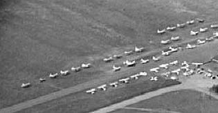
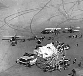
Here are two images that my sources definitely identify as Mullinix Field


I have a fair few more that are labelled Tarawa, (construction and use), and may well be Mullinix, but can't be 100% sure.
Also have photos of Line & Phoenix islands PM sent
Here are two images that my sources definitely identify as Mullinix Field
I have a fair few more that are labelled Tarawa, (construction and use), and may well be Mullinix, but can't be 100% sure.
Also have photos of Line & Phoenix islands
PM sent
Jeez -that was the best challenge in a year I think - whats worse is I've been to Bonriki 
OH so let's try this one (not in the Pacific)
OH so let's try this one (not in the Pacific)
Not Europe...
USA - correct
Mid-West.... now that is an area even Americans can't agree on - at least on the boundaries.... let's say east of the Rocky Mt front and west of the Appalachians?
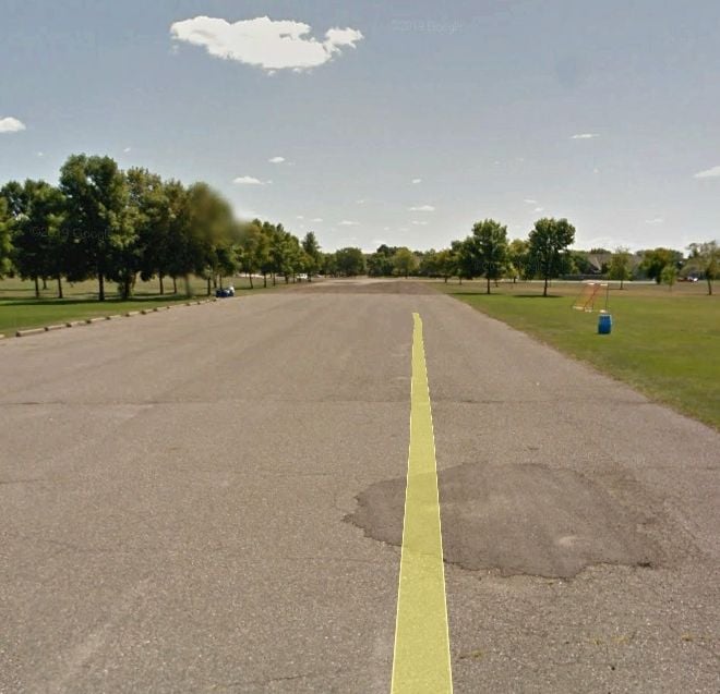
This airfield was the second in the area and was itself later closed.... today it looks like this (yellow line from Street view I'm afraid)
PS Note SOCCA pitches -how things have changed in the USA..........
Mid-West.... now that is an area even Americans can't agree on - at least on the boundaries.... let's say east of the Rocky Mt front and west of the Appalachians?
This airfield was the second in the area and was itself later closed.... today it looks like this (yellow line from Street view I'm afraid)
PS Note SOCCA pitches -how things have changed in the USA..........
OKie or Kansas...?
no sir, neither of those fair states..... nor are we in the Confederacy...............
