


 2nd Mar 2020, 14:35 - Wikipost
|
|||
|
|||

Which Aerodrome Mk III
Not Mooliabeenee - I don't think there were ever any hangars there.

A clue: the runway shown ceased being used in late 1943, but the maintenance/erection/conversion/overhaul activities here continued unabated.
Join Date: Feb 2002
Location: at my computer
Posts: 250
Likes: 0
Received 0 Likes
on
0 Posts
OK. I cheated a bit to get some clues, so I won't claim the prize.
However, this may help someone else find the location, if Dora9 reckons I am correct.
The original photo resolution is good enough to see that a lot of the aircraft are B-24 Liberators which limits the location to places that saw this type during WW2.
Google Earth nailed the physical layout for me and the timeline showed how the path of the creek had changed several times, while the layout of the roads was substantially unchanged.
This place is now a bl**dy shopping centre in suburbia, and only 3km from a major airport, and 6km from the city centre.
How times have changed!
I recall that in the early 60's a lot of those roads in the area were still recognisable as taxiways. There must have been hangars and dispersals all around the area.
I shall also join T2 and observe from the sidelines. Preferably under a tree as its much too hot around here at present !
Emeritus
I shall also join T2 and observe from the sidelines. Preferably under a tree as its much too hot around here at present !
Emeritus
Ted has it nailed, but what was its name?
Garbutt lies immediately to the north, the road/taxiway that goes to the top RH corner of my photo actually connects it, hence maintenance operations continuing after the runway was closed. I rather suspect it was inadequate for a B-24 anyway.
Garbutt lies immediately to the north, the road/taxiway that goes to the top RH corner of my photo actually connects it, hence maintenance operations continuing after the runway was closed. I rather suspect it was inadequate for a B-24 anyway.
Yes, it's Stockroute (sometimes written as one word).
Well done Noyade - over to you.
Well done Noyade - over to you.
Noyade, while you certainly have the con, may I interject some more comments on Stocktoute?
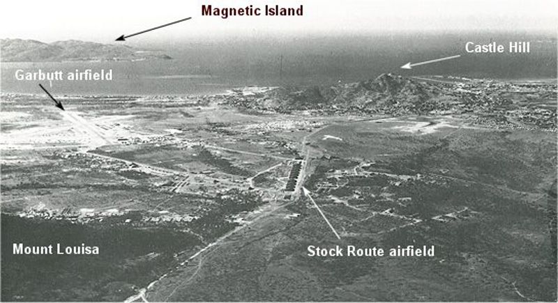
This photo, looking in a north-easterly direction, shows the relationship between Stockroute and Garbutt (now Townsville Airport). Note the prominent line of buildings appearing on what was the Stockroute (written here as "Stock Route") runway - immediately after the runway closed (29/11/1943) the Americans erected a line of 11 Butler hangars/warehouses (steel frames but canvas walled) here.
Of all the "inner" Townsville airfields, Stockroute, Aitkenvale and Ross River have all disappeared beneath the urban sprawl, while only Bohle River is still obvious...

Join Date: Feb 2002
Location: at my computer
Posts: 250
Likes: 0
Received 0 Likes
on
0 Posts
Lots of small aircraft, vehicles and people walking about.
Some sort of old pivoting wind/traffic indicator thingy in the circle with the windsock.
Is it some ancient airshow? In Oz?
Some sort of old pivoting wind/traffic indicator thingy in the circle with the windsock.
Is it some ancient airshow? In Oz?
G'day Terry.
The photo is from 1994 and shows some 2,000 aircraft. This airport hosted an annual Antique Fly-In from 1957 to 2007.
California....
Is it some ancient airshow? In Oz?
California....
Join Date: Feb 2002
Location: at my computer
Posts: 250
Likes: 0
Received 0 Likes
on
0 Posts
Right.
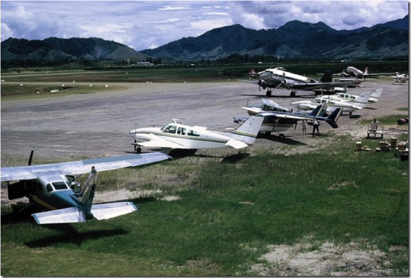
Mountains, Talair C206, B55 Barons, Push-pull C336, Dark person loading freight, DC-3s, one with a blue tail (TAA), one with a red tail with logo not completely photoshopped out (MAL).
Gotta be New Guinea.
Mount Hagen?
Mountains, Talair C206, B55 Barons, Push-pull C336, Dark person loading freight, DC-3s, one with a blue tail (TAA), one with a red tail with logo not completely photoshopped out (MAL).
Gotta be New Guinea.
Mount Hagen?
I knew it wouldn't last long with all the ex-PNG types that hang around here 
The photo was sent to me by Mike Feeney, who amongst his myriad roles, was "Director-Air Safety;PNG". His caption for the photo is:
FYI, Mike publishes a very interesting email newsletter called "Our Pacific Skies - An Aviator's Diary". Send me your address if you are interested and I'll pass it on to him.
Terry has control.
The photo was sent to me by Mike Feeney, who amongst his myriad roles, was "Director-Air Safety;PNG". His caption for the photo is:
Just a nice day at Kagamuga (Mount Hagen) not long
after the new aerodrome was opened in 1965.
after the new aerodrome was opened in 1965.
Terry has control.