


AA5342 Down DCA


Joined: Mar 2010
Aviation Qualifications: ATCO
Posts: 8,023
Likes: 314
From: Often in Jersey, but mainly in the past.
My earlier questions remain unanswered … does DCA Tower have a slaved radar display?
And thus could Tower have used that data to direct PAT21 out of the way, regardless of qualification or licensing? Or did Tower have a Radar qualification anyway, but didn’t use it?


Joined: Oct 2002
Aviation Qualifications: PPL
Posts: 8,208
Likes: 351
From: London UK
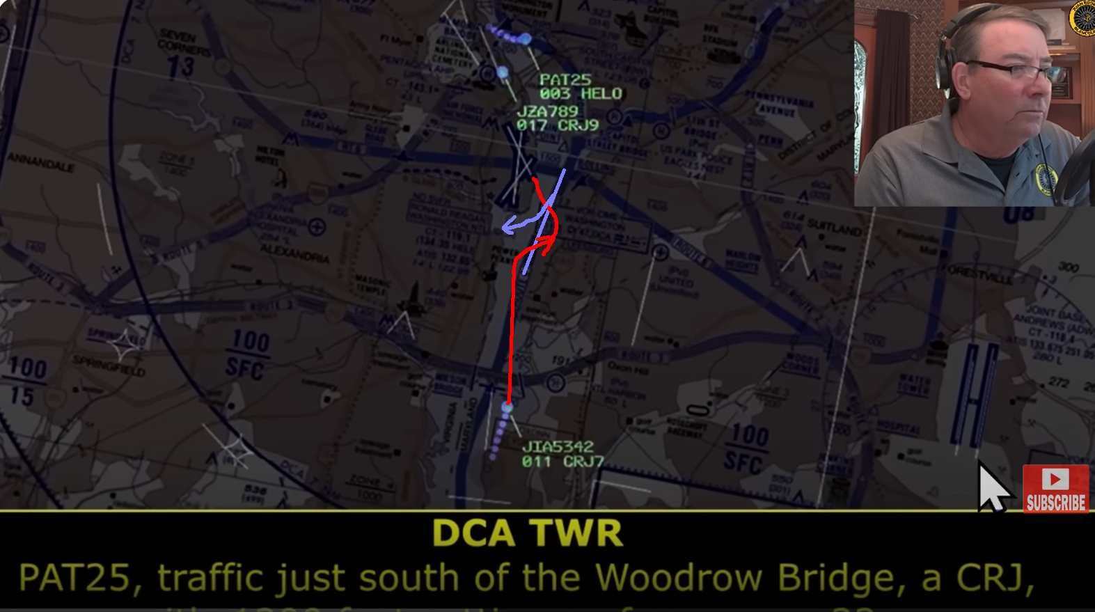
There were a number of aircraft around in the dark, which makes repeated unqualified reference just to "the CRJ" quite liable to error. I still wonder if the "Can you see the CRJ ... pass behind the CRJ" was being interpreted as the aircraft on the ground lining up on 01, the nearest aircraft to them and just on their right. They could see it, and they turned to pass behind it.


Joined: Jul 2013
Aviation Qualifications: CPL
Posts: 611
Likes: 474
From: Maryland USA
There were a number of aircraft around in the dark, which makes repeated unqualified reference just to "the CRJ" quite liable to error. I still wonder if the "Can you see the CRJ ... pass behind the CRJ" was being interpreted as the aircraft on the ground lining up on 01, the nearest aircraft to them and just on their right. They could see it, and they turned to pass behind it.
Joined: Aug 2015
Posts: 40
Likes: 88
From: London, UK
?.
Was there a change to the definition of VHF and UHF that we didn't get the memo on?
Our own versions of the 60 have needs for VHF along with FM, UHF and HF, secure or not. Presumably the USA doesn't use an ICOM A23 or similar when dropping in to some towns local airstrip. ARC-231"s? using a UHF freq when mixing with civil traffic would be self limiting, presumably the tapes will indicate the helo was on VHF freq not the UHF one.
It seems that radio marketers do call 257.6 MHz UHF. Go figure

Pegase Driver

Joined: May 1997
Aviation Qualifications: ATCO
Posts: 4,456
Likes: 1,168
From: Europe
and
Does a non-trained/qualified controller have the authority to use that data in extremis?
.
If you are a controller you know how we work , Problem identified , = Conflict with PT detected , solution found = delegate separation , delegation accepted = problem solved. Next ... The guy was quite busy with departing and arrival traffic in runway one . Now of course with hindsight ,, what he should, and could perhaps have done is very easy for us to say . Feel very sorry for the guy . I hope he is not made the scapegoat for this mess.
Moderator

Joined: May 1997
Aviation Qualifications: ATCO
Posts: 295
Likes: 138
From: Europe
Joined: Jul 2009
Aviation Qualifications: PPL
Posts: 167
Likes: 56
From: France
There were a number of aircraft around in the dark, which makes repeated unqualified reference just to "the CRJ" quite liable to error. I still wonder if the "Can you see the CRJ ... pass behind the CRJ" was being interpreted as the aircraft on the ground lining up on 01, the nearest aircraft to them and just on their right. They could see it, and they turned to pass behind it.
Last edited by spornrad; 3rd February 2025 at 22:06.
Joined: Oct 2004
Posts: 118
Likes: 53
From: NY - USA
That is a question I posed way back. Does DCA Tower have a slaved radar display? Does a non-trained/qualified controller have the authority to use that data in extremis? Personally, as an ATCO, and presented with imminently co-altitude and virtually head-on conflicting traffic, I would have intervened. But then I was always an interventionist Tower controller!
My earlier questions remain unanswered � does DCA Tower have a slaved radar display?
And thus could Tower have used that data to direct PAT21 out of the way, regardless of qualification or licensing? Or did Tower have a Radar qualification anyway, but didn�t use it?
My earlier questions remain unanswered � does DCA Tower have a slaved radar display?
And thus could Tower have used that data to direct PAT21 out of the way, regardless of qualification or licensing? Or did Tower have a Radar qualification anyway, but didn�t use it?
Joined: Mar 2014
Posts: 9
Likes: 0
From: Dallas
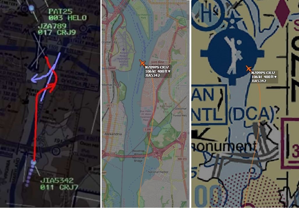
Altimeter setting vs Altimeter error amount?
The Helicopter wasn't landing at DCA, but, most likely would have the airports barometric setting in it's altimeter? If it was off by 0.2 inches, that would be about 200 ft?
I assume the altitude reading that the Altimeter in the aircraft displays in the cockpit is identical to the Transponded signal that ATC shows on it's screen? Is there a chance
that the Helicopter would have a different altimeter setting set? A new ATIS came out recently, or a pressure front was moving in?

Joined: Jun 2009
Posts: 164
Likes: 13
From: UK
The Helicopter wasn't landing at DCA, but, most likely would have the airports barometric setting in it's altimeter? If it was off by 0.2 inches, that would be about 200 ft?
I assume the altitude reading that the Altimeter in the aircraft displays in the cockpit is identical to the Transponded signal that ATC shows on it's screen? Is there a chance
that the Helicopter would have a different altimeter setting set? A new ATIS came out recently, or a pressure front was moving in?
I assume the altitude reading that the Altimeter in the aircraft displays in the cockpit is identical to the Transponded signal that ATC shows on it's screen? Is there a chance
that the Helicopter would have a different altimeter setting set? A new ATIS came out recently, or a pressure front was moving in?
Although the route / approach crossed the main plan was surely to never let two aircraft on different courses /stages get even 10 times that close in passing . . which takes us back to the real issue
Joined: May 2005
Posts: 271
Likes: 145
From: Ontario, Canada
They'd already said "Tower, we had an RA. Brickyard 4514 is going around" and that was acknowledged. They were then switched to Potomac who confirmed radar contact and asked reason for go around again. I would hope Potomac had seen/heard the "CA". But then after this everyone just carries on as if this is all perfectly normal until we all know what happened the very next day.
He�s asking the reason to find out what the a/c wants: sequence for another approach, divert due weather, hold to work out a technical fault.
Tower could have passed it on the hotline but it is probably normally more efficient to just have the a/c say.
Working about the safety implication of why the RA and what it says about the procedure is not something for the radio.
Joined: Dec 2007
Posts: 953
Likes: 451
From: same planet as yours
Unlikely. The helicopter crew was told about the CRJ approaching 33. At the moment of that initial traffic advisory it meant, the CRJ would first cross their flight path from right to left, and then later on final (circle to land) from left to right. Did they simply expect still the former, seeing the second jet, misjudging the timing / distance as to the CRJ, and therefore turning right to pass behind / give way to an approaching aircraft espected to cross their path from right to left?
No crossing of 'Route 4' prior to ...
Joined: Dec 2007
Posts: 953
Likes: 451
From: same planet as yours
Joined: Jan 2008
Posts: 81
Likes: 36
From: UK
Joined: Sep 2008
Aviation Qualifications: ATPL
Posts: 3,435
Likes: 1,202
From: 41S174E
Either way, the controller does not have enough information to use a heading � neither to know one is needed nor what it should be .
Thanks
Joined: Dec 2007
Posts: 953
Likes: 451
From: same planet as yours
I have never flown in the United States so am not sure, but if this was Australia the controller couldn�t give the helicopter a vector while it is below the minimum vectoring altitude anyway. I would be surprised if the controller in DC was able to legally issue a heading instruction to the Blackhawk while it is at or below 200ft at night. Can one of the American readers correct me if I am wrong?
Thanks
Thanks
Joined: Dec 2007
Posts: 953
Likes: 451
From: same planet as yours
VHF, UHF, .... the important fact is that pilots were on different frequencies...whatever spectrum band they were on, is less relevant.
But for those rebuking any mentioning of a VHF Heli frequency, please provide some proof as any reference I find on VFR sectionals, is a VHF Heli-frequency.
IFR charts only have the regular VHF+UHF TWR freq.
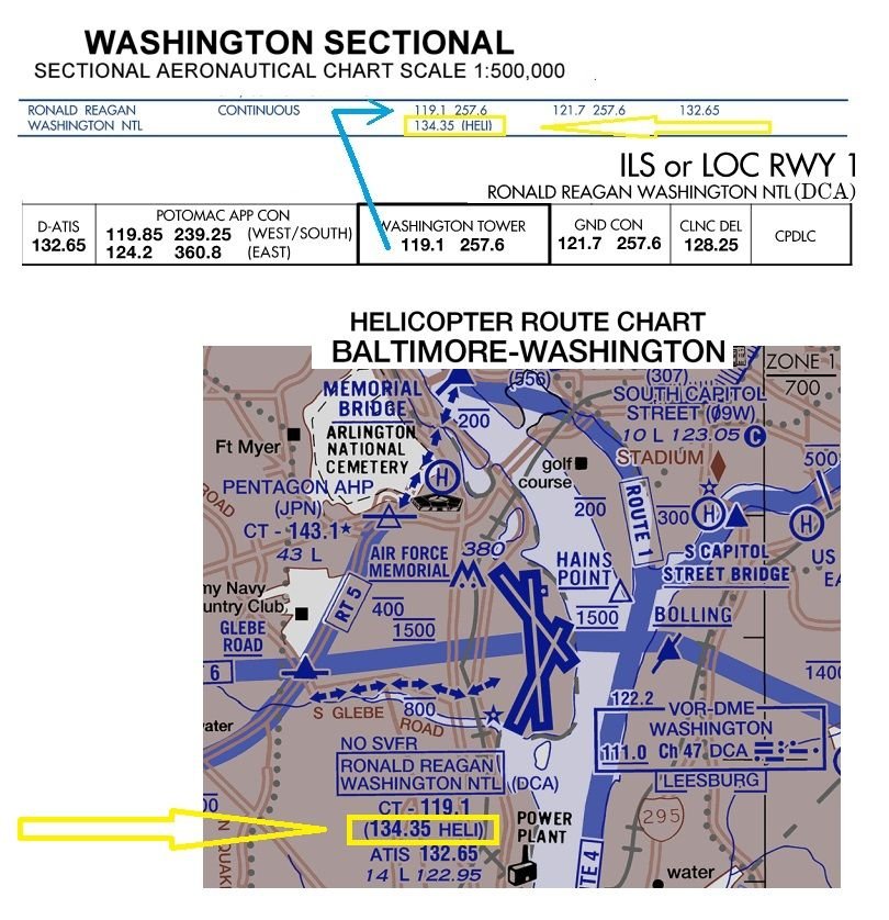
But for those rebuking any mentioning of a VHF Heli frequency, please provide some proof as any reference I find on VFR sectionals, is a VHF Heli-frequency.
IFR charts only have the regular VHF+UHF TWR freq.

Joined: Jan 2020
Posts: 142
Likes: 96
From: Bucharest
I agree that these are just guesses, but the alternative seems to be that the helo just drifted to the right randomly, for no specific reason, which seems unlikely.